Showing 7911 items
matching range road
-
 Ringwood and District Historical Society
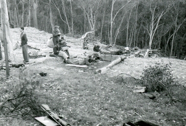
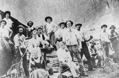
Photograph, Ringwood Rifle Range 500 yard mound. Shooting against Christmas Hills. W Gough on left, Unknown date
Digital photograph -
 Ringwood and District Historical Society
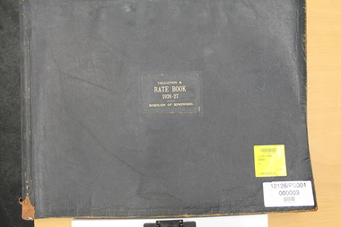
Administrative record - Parent Record, Borough of Ringwood Rate Books for 1924-49
The rate books are a primary source about Ringwood ratepayers, as well as indicating street and estate names.This is the parent record for the Borough of Ringwood Rate Book collection. The VC Reference Number range 33001-34999 has been reserved. The Borough of Ringwood was created in December 1924, formally part of the South-West riding of the Shire of Lillydale. Ringwood was proclaimed a city on 19 March 1960. On 15 December 1994, the City of Ringwood was amalgamated to form part of Maroondah City Council. The detailed years are: 1924-25, 1926-27, 1928-29, 1930-31, 1932-34, 1934-35 and 1944-49. For researchers, the rate books are in assessment number sequence. Occasionally, they is also in surname or estate sequence but do not rely on this. The original records are kept at PROV, North Melbourne. At 13/3/2021 the bulk of the collection is being processed ready for a bulk load to Victorian Collections. Digitised by Mark Grealy c/o Archival Access Victoria (www.archivalaccessvictoria.com)rate book, borough of ringwood, rates, street names, ratepayers -
 Flagstaff Hill Maritime Museum and Village
Lead shot, Before 1878
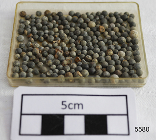
The objects comprise a quantity of small calibre lead shot raised from the LOCH ARD shipwreck site by Flagstaff Hill divers in 1976. The Maritime Village’s collection has companion pieces. The three masted, iron hulled, LOCH ARD was wrecked against the tall limestone cliffs of Mutton Bird Island in the early hours of the first of June 1878. Included in her diverse and valuable cargo were 22 tons of lead shot, packed in cloth bags and wooden casks. Bulk quantities of lead shot, uniformly round balls of dull grey metal ranging from 2mm “birdshot” to 8mm “buckshot”, were routinely exported to the Australian colonies. Shot was used mostly as projectiles fired from smooth bored guns to bring down moving targets such as wild ducks and small game. It was also useful as ballast, when a dense, “pourable” weight was required to fill cavities or establish volume within a measuring container. The production of consistently round spheres of lead shot required the pouring of molten metal through a sieve and then a long drop through the atmosphere to a water filled basin for final cooling and collection. This “shot tower” process was first patented by William Watts of Bristol in 1782. His calculation of a 150 feet fall was not only to form evenly spherical droplets through surface tension, but also to provide partial cooling and solidification to each shot before they hit the water below. The value of his innovation was the minimising of indentation and shape distortion, avoiding the expense of re-smelting and re-moulding the lead. Lead shot was already being produced in Australia at the time the LOCH ARD loaded her cargo and left Gravesend on the second of March 1878. James Moir constructed a 157 feet circular stone shot tower near Hobart in 1870, with a peak annual production of 100 tons of lead shot sold in 28 pound linen bags. However colonial demand exceeded this source of local supply. The continued strength of the market for lead shot in the Colony of Victoria prompted substantial investment in additional productive capacity in Melbourne in the next decade. In 1882 Richard Hodgson erected the 160 feet round chimney-shaped Clifton Hill shot tower on Alexandra Parade (VHR H0709) and in 1889 Walter Coop built the 160 feet square tower-shaped Melbourne Central shot tower on La Trobe Street (VHR H0067). At its peak, the Coop Tower produced 6 tons of lead shot per week, or 312 tons per annum. HISTORY OF THE LOCH ARD The LOCH ARD belonged to the famous Loch Line which sailed many ships from England to Australia. Built in Glasgow by Barclay, Curdle and Co. in 1873, the LOCH ARD was a three-masted square rigged iron sailing ship. The ship measured 262ft 7" (79.87m) in length, 38ft (11.58m) in width, 23ft (7m) in depth and had a gross tonnage of 1693 tons. The LOCH ARD's main mast measured a massive 150ft (45.7m) in height. LOCH ARD made three trips to Australia and one trip to Calcutta before its final voyage. LOCH ARD left England on March 2, 1878, under the command of Captain Gibbs, a newly married, 29 year old. She was bound for Melbourne with a crew of 37, plus 17 passengers and a load of cargo. The general cargo reflected the affluence of Melbourne at the time. On board were straw hats, umbrella, perfumes, clay pipes, pianos, clocks, confectionary, linen and candles, as well as a heavier load of railway irons, cement, lead and copper. There were items included that intended for display in the Melbourne International Exhibition in 1880. The voyage to Port Phillip was long but uneventful. At 3am on June 1, 1878, Captain Gibbs was expecting to see land and the passengers were becoming excited as they prepared to view their new homeland in the early morning. But LOCH ARD was running into a fog which greatly reduced visibility. Captain Gibbs was becoming anxious as there was no sign of land or the Cape Otway lighthouse. At 4am the fog lifted. A man aloft announced that he could see breakers. The sheer cliffs of Victoria's west coast came into view, and Captain Gibbs realised that the ship was much closer to them than expected. He ordered as much sail to be set as time would permit and then attempted to steer the vessel out to sea. On coming head on into the wind, the ship lost momentum, the sails fell limp and LOCH ARD's bow swung back. Gibbs then ordered the anchors to be released in an attempt to hold its position. The anchors sank some 50 fathoms - but did not hold. By this time LOCH ARD was among the breakers and the tall cliffs of Mutton Bird Island rose behind the ship. Just half a mile from the coast, the ship's bow was suddenly pulled around by the anchor. The captain tried to tack out to sea, but the ship struck a reef at the base of Mutton Bird Island, near Port Campbell. Waves broke over the ship and the top deck was loosened from the hull. The masts and rigging came crashing down knocking passengers and crew overboard. When a lifeboat was finally launched, it crashed into the side of LOCH ARD and capsized. Tom Pearce, who had launched the boat, managed to cling to its overturned hull and shelter beneath it. He drifted out to sea and then on the flood tide came into what is now known as LOCH ARD Gorge. He swam to shore, bruised and dazed, and found a cave in which to shelter. Some of the crew stayed below deck to shelter from the falling rigging but drowned when the ship slipped off the reef into deeper water. Eva Carmichael had raced onto deck to find out what was happening only to be confronted by towering cliffs looming above the stricken ship. In all the chaos, Captain Gibbs grabbed Eva and said, "If you are saved Eva, let my dear wife know that I died like a sailor". That was the last Eva Carmichael saw of the captain. She was swept off the ship by a huge wave. Eva saw Tom Pearce on a small rocky beach and yelled to attract his attention. He dived in and swam to the exhausted woman and dragged her to shore. He took her to the cave and broke open case of brandy which had washed up on the beach. He opened a bottle to revive the unconscious woman. A few hours later Tom scaled a cliff in search of help. He followed hoof prints and came by chance upon two men from nearby Glenample Station three and a half miles away. In a state of exhaustion, he told the men of the tragedy. Tom returned to the gorge while the two men rode back to the station to get help. By the time they reached LOCH ARD Gorge, it was cold and dark. The two shipwreck survivors were taken to Glenample Station to recover. Eva stayed at the station for six weeks before returning to Ireland, this time by steamship. In Melbourne, Tom Pearce received a hero's welcome. He was presented with the first gold medal of the Royal Humane Society of Victoria and a £1000 cheque from the Victorian Government. Concerts were performed to honour the young man's bravery and to raise money for those who lost family in the LOCH ARD disaster. Of the 54 crew members and passengers on board, only two survived: the apprentice, Tom Pearce and the young woman passenger, Eva Carmichael, who lost all of her family in the tragedy. Ten days after the LOCH ARD tragedy, salvage rights to the wreck were sold at auction for £2,120. Cargo valued at £3,000 was salvaged and placed on the beach, but most washed back into the sea when another storm developed. The wreck of LOCH ARD still lies at the base of Mutton Bird Island. Much of the cargo has now been salvaged and some was washed up into what is now known as LOCH ARD Gorge. Cargo and artefacts have also been illegally salvaged over many years before protective legislation was introduced. One of the most unlikely pieces of cargo to have survived the shipwreck was a Minton porcelain peacock - one of only nine in the world. The peacock was destined for the Melbourne International Exhibition in 1880. It had been well packed, which gave it adequate protection during the violent storm. Today, the Minton peacock can be seen at the Flagstaff Hill Maritime Museum in Warrnambool. From Australia's most dramatic shipwreck it has now become Australia's most valuable shipwreck artefact and is one of very few 'objects' on the Victorian State Heritage Register. The shipwreck of the LOCH ARD is of State significance – Victorian Heritage Register S417 Flagstaff Hill’s collection of artefacts from LOCH ARD is significant for being one of the largest collections of artefacts from this shipwreck in Victoria. It is significant for its association with the shipwreck, which is on the Victorian Heritage Register (VHR S417). The collection is significant because of the relationship between the objects, as together they have a high potential to interpret the story of the LOCH ARD. The LOCH ARD collection is archaeologically significant as the remains of a large international passenger and cargo ship. The LOCH ARD collection is historically significant for representing aspects of Victoria’s shipping history and its potential to interpret sub-theme 1.5 of Victoria’s Framework of Historical Themes (living with natural processes). The collection is also historically significant for its association with the LOCH ARD, which was one of the worst and best known shipwrecks in Victoria’s history. A quantity of lead shot pellets retrieved from the wreck of the LOCH ARD. There are 242 loose 2mm pieces and 17 loose 4mm pieces. They are in good condition, with some shape distortion and sedimentary concretion, and shot tower made.flagstaff hill, warrnambool, shipwrecked coast, flagstaff hill maritime museum, maritime museum, shipwreck coast, flagstaff hill maritime village, great ocean road, loch line, loch ard, captain gibbs, eva carmichael, tom pearce, glenample station, mutton bird island, loch ard gorge, lead shot, colonial industry, melbourne shot towers, victorian metallurgy, colonial imports -
 Flagstaff Hill Maritime Museum and Village
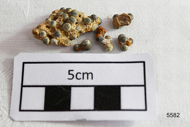
Weapon - Ammunition, Before 1878
The objects are a small sample of small gauge lead shot raised by Flagstaff Hill divers from the LOCH ARD shipwreck site in 1976. Companion pieces are in the Maritime Village collection. The three masted, iron hulled, LOCH ARD was wrecked against the tall limestone cliffs of Mutton Bird Island in the early hours of the first of June 1878. Included in her diverse and valuable cargo were 22 tons of lead shot, packed in cloth bags and wooden casks. Bulk quantities of lead shot, uniformly round balls of dull grey metal ranging from 2mm “birdshot” to 8mm “buckshot”, were routinely exported to the Australian colonies. Shot was used mostly as projectiles fired from smooth bored guns to bring down moving targets such as wild ducks and small game. It was also useful as ballast, when a dense, “pourable” weight was required to fill cavities or establish volume within a measuring container. The production of consistently round spheres of lead shot required the pouring of molten metal through a sieve and then a long drop through the atmosphere to a water filled basin for final cooling and collection. This “shot tower” process was first patented by William Watts of Bristol in 1782. His calculation of a 150 feet fall was not only to form evenly spherical droplets through surface tension, but also to provide partial cooling and solidification to each shot before they hit the water below. The value of his innovation was the minimising of indentation and shape distortion, avoiding the expense of re-smelting and re-moulding the lead. Lead shot was already being produced in Australia at the time the LOCH ARD loaded her cargo and left Gravesend on the second of March 1878. James Moir constructed a 157 feet circular stone shot tower near Hobart in 1870, with a peak annual production of 100 tons of lead shot sold in 28 pound linen bags. However colonial demand exceeded this source of local supply. The continued strength of the market for lead shot in the Colony of Victoria prompted substantial investment in additional productive capacity in Melbourne in the next decade. In 1882 Richard Hodgson erected the 160 feet round chimney-shaped Clifton Hill shot tower on Alexandra Parade (VHR H0709) and in 1889 Walter Coop built the 160 feet square tower-shaped Melbourne Central shot tower on La Trobe Street (VHR H0067). At its peak, the Coop Tower produced 6 tons of lead shot per week, or 312 tons per annum. The shipwreck of the LOCH ARD is of State significance – Victorian Heritage Register S417 Flagstaff Hill’s collection of artefacts from LOCH ARD is significant for being one of the largest collections of artefacts from this shipwreck in Victoria. It is significant for its association with the shipwreck, which is on the Victorian Heritage Register (VHR S417). The collection is significant because of the relationship between the objects, as together they have a high potential to interpret the story of the LOCH ARD. The LOCH ARD collection is archaeologically significant as the remains of a large international passenger and cargo ship. The LOCH ARD collection is historically significant for representing aspects of Victoria’s shipping history and its potential to interpret sub-theme 1.5 of Victoria’s Framework of Historical Themes (living with natural processes). The collection is also historically significant for its association with the LOCH ARD, which was one of the worst and best known shipwrecks in Victoria’s history. A quantity of 2mm and 4mm lead shot ammunition retrieved from the LOCH ARD shipwreck site. They are concreted together by sediment. There are (6) small pieces with some single shot and a larger conglomerate of cemented shot. flagstaff hill, warrnambool, shipwrecked coast, flagstaff hill maritime museum, maritime museum, shipwreck coast, flagstaff hill maritime village, great ocean road, loch line, loch ard, captain gibbs, eva carmichael, tom pearce, glenample station, mutton bird island, loch ard gorge, lead shot, colonial industry, melbourne shot towers, victorian metallurgy, colonial imports -
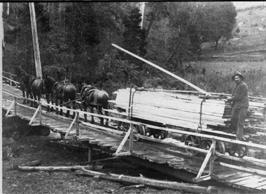 Upper Yarra Museum
Negative Photographic Reproduction, Arthur Witnish's horse team hauling timber across bridge over Black Sands Creek, 14.2.1983
Black and white negative of Arthur Witnish's horse team hauling timber across bridge on Black Sands Road. Negative Black white. Scanned at 600 dpibridge, timber, arthur witnish, horse team, tramway, black sands creek, timber truck, gladysdale -
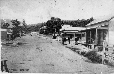 Upper Yarra Museum
Negative Photographic Reproduction, Main St Yarra Junction
This intersection was a busy one with the tramway traffic having Steam Engines and their trucks crossing about 8 times a day, horsedrawn vehicles often had trouble crossing the tramway because it was quite uneven at times.03037 PC Main Street Yarra Junction, at the corner of Little Yarra Rd, the Powelltown tramway crosses the road at this intersection Upper Yarra Shire 1888-1988 Centenary collection. Negative, Black & white. Scanned at 600 dpi. yarra junction main street rail crossing -
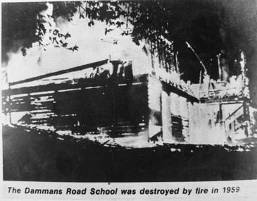 Upper Yarra Museum
Negative Photographic Reproduction, Dammans Road school (destroyed by fire 1959) Warburton, 14.9.1983
Print in Collection of Photographs compiled by R Crowley from the History Committee Shire of Upper Yarra for UYVHS 1988Dammans Road school (destroyed by fire 1959) Warburton. Negative Black white. Scanned at 600 dpi dammans road school destroyed fire warburton 1959 -
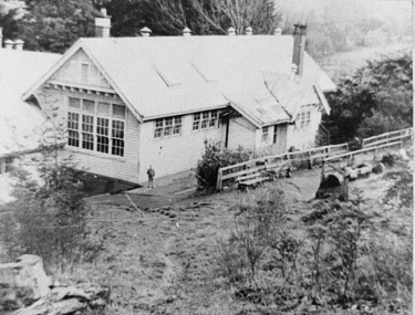 Upper Yarra Museum
Negative Photographic Reproduction, Damman’s Rd school 1940 Warburton, 14.9.1983
Print in Collection of Photographs compiled by R Crowley from the History Committee Shire of Upper Yarra for UYVHS 1988Damman’s Rd school 1940 Warburton Negative Black white. Scanned at 600 dpidammans road school warburton 1940 -
 Upper Yarra Museum
Negative Photographic Reproduction, Working party on Highfield Rd. Warburton
... Highway Yarra Junction yarra-valley-and-dandenong-ranges working ...Working party on Highfield Rd. Warburton Negative Black white Scanned at 600 dpiworking party highfield road warburton -
 Warrnambool and District Historical Society Inc.
Administrative record - Minutes Book Sub Committees, Warrnambool City Council 1950-1973, Circa 1950
This book contains the minutes from a wide range of community groups such as Sun Youth Travel Scheme, Foreshore Reserve Committee of Management, Victorian Centenary Celebration, and Testimonials for various councillors, Freedom from Hunger Campaign, Historical Society, Miss Australia Quest, Meals on Wheels, Winston Churchill Memorial Appeal, and Warrnambool Cricket Grand Reserve. The meetings were held in the period 1950 to 1973.An interesting collection of minutes with a very diverse cross-section of community groups. It shows the workings of councillors with a range of community groups some of which such as Meals On Wheels have become an important part of community support for people. Red cover. Navy blue and white patterned inside front and back covers.188 blue lined pages with handwritten minutes for various sub committees and community groups.The letter M on base of spine. A shell series Product No 4222. warrnambool, minute book minutes book 1950- 1973, warrnambool and district historical society, sun youth travel scheme, warrnambool foreshore reserve committee of management, victorian centenary celebration, freedom from hunger campaign, miss australia quest, meals on wheels, winston churchill memorial appeal, warrnambool cricket grand reserve -
 Warrnambool and District Historical Society Inc.
Book, Register of Mortgagees, Early 20th century
This Register of Mortgagees comes from the Warrnambool legal firm of Fletcher and Mackay which resulted from the merger of the firms of George Sutherland Mackay and James Fletcher in 1893. G.S. Mackay was a prominent resident of Warrnambool from 1891 to his death in 1926. In the 1920s Mr J. Taylor became a partner in the firm known then as Mackay and Taylor and the firm later known as Mackay Taylor was in operation until the 1990s at 131 Kepler Street. The Register of Mortgagees with dates ranging from 1908 to 1924 comes from the old Mackay Taylor offices in the Kepler Street building.This Register of Mortgagees is of some significance as it contains information on many families living in Warrnambool in the early 20th century, including those of Burleig, Swinton, Uebergang, Turland, Bates, Wood and Paton. The entries have social significance, showing the typical loans taken out at the time and the prevailing interest rates. This is a small quarto sized ledger containing 166 pages of a register of mortgagees. The pages have been printed with ruled red lines. The cover is bound with a black cover and a red spine. There are pages with alphabetical tabs at the start of the book. The entries are in black ink. There is one loose page which is an old envelope used as scrap paper to record names and amounts owing or paid. Front cover (paper pasted on) – ‘Register of Mortgagees’mackay taylor legal firm warrnambool mortgagees, warrnambool mortgagees, swinton, uebergang -
 Warrnambool and District Historical Society Inc.
Financial record - Ledger, Warrnambool Shire Council 1899-1918, Circa 1900
Provides a collection of letters to the President and Councillors of the Shire of Warrnambool from J. M. Crawley. The period covered is 1900 to 1918. It covers such topics as repairs to bridges, purchasing of equipment, complaints, applications for roads. Names of places and structures include Dennington Bridge, Cassidy’s Bridge, Warrumyea Bridge, Yangery, Purnim. Loose within the book is a letter from a W,M(H?) Clarke of Garvoc. The letters contained in this ledger provide information on a large range of works which were carried out in the Shire in the early 1900’sDark olive green fabric cover with tan spine and cornersMinute Book in gold lettering on red background on spine.warrnambool shire council 1899-1918, crawley j w crawley, warrnambool shire offices, warrnambool -
 Warrnambool and District Historical Society Inc.
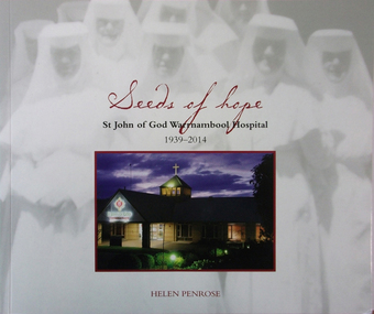
Book, Helen Penrose, Seeds of Hope St John of God Hospital Warrnambool 1939-2014, 2014
History of St John of God Hospital, Warrnambool 1939-2014This is a book of 78 pages with a stiffened cardboard cover. The cover is greyish-white with a colour photograph of the hospital and background blurred images of St John of God nuns on the front cover. The book contains printed material, maps, tables, black and white and colour photographs and illustrations.non-fictionHistory of St John of God Hospital, Warrnambool 1939-2014st john of god warrnambool hospital, glenrye, healthcare, warrnambool -
 Warrnambool and District Historical Society Inc.
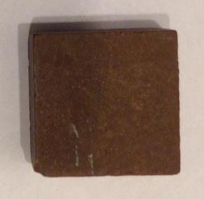
Functional object - Artefact, Sharpening stone
This is an early sharpening stone of unknown origin . Stones have been used for hundreds of years to sharpen metal blades on a wide range of tools from scythes, scissors plane blades and knives. More recent examples come with particular grades according to the fineness of the grit in the stone.This item is of antiquarian interest only and is kept for displays. It is an example of tool sharpening methods which have been used for many years.This is a small square stone with a polished surface used to sharpen small bladestrade, sharpening stone, warrnambool -
 Warrnambool and District Historical Society Inc.
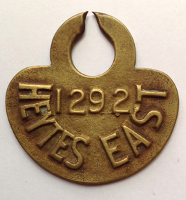
Functional object - Tag, cow Heytesbury East, late 20th century
The Heytesbury Settlement Scheme in the area west of Colac and bordering the Otway Ranges. The Settlement was established in 1960 as a dairying area and was one of the largest post World War Two farming settlements. This cow tag has been broken at the top and detached from the animal.The item is of some interest as coming from the Heytesbuty Settlement. Dairying is of major importance in the Warrnambool area and this extends to the Heytesbury area. These cow tags have now been superseded by more improved technological equipment. This is a brass cow tag. It is semi-circular with a ring top, broken or worn through at the top. ‘1292’ ‘Heytes East’ heytesbury settlement scheme, cow tag -
 Warrnambool and District Historical Society Inc.
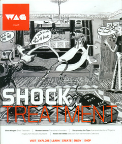
Work on paper - Periodical, WAGazine No.1, 2014
This magazine lists events and exhibitions which are current at this time. The events listed range from an interview with a local artist to exhibitions, designer of the month, public programs, and Sunday musicA record of current events and some of the people involved in the Warrnambool Art Gallery. 14 page magazine. Cover is black and white with some orange highlights. Most of the pages are printed in colour. Back cover is orange.warrnambool history, warrnambool art gallery 2014, warrnambool wag -
 Warrnambool and District Historical Society Inc.
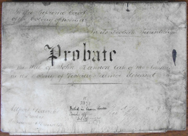
Document, John Hannon Probate 1874, 1875
This is the probate and will of John Hannon of the Anakies. John Hannon died in March 1874. Anakie is a small town between Geelong and Bacchus Marsh and the Anakies are three small hills in the nearby Brisbane Ranges National Park. Nothing is known of John Bannon except for the details in the will and probate. He was unable to read and write, signing his will with a cross and he was a small handholder having property valued at under £300. He left his estate to his wife Johanna and her family. The probate document is signed by R.W. Pohlman, Acting Master in EquityThis document is only of interest in that it came from a local Warrnambool legal office in Kepler Street. It originally came from Thomas Goodall, a legal clerk in the office of lawyer Ernest Chambers who passed it on to George Mackay, the lawyer in the forerunner firm of the legal firm of Mackay Taylor. The document came the buildings that previously housed the firm of Mackay Taylor. This is a piece of parchment folded in two and joined at the fold by a piece of green ribbon to which is attached a government seal (Supreme Court of the Colony of Victoria). The parchment is much discoloured and the seal is torn. The contents are handwritten in black ink. ‘Probate on the will of John Hannon, late of the Anakies, in the colony of Victoria, Farmer, deceased’john bannon, anakies, warrnambool -
 Warrnambool and District Historical Society Inc.
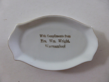
Pin Dish, Mrs Wm Wright Warrnambool, C mid 20th century
Mrs William Wright operated a shop at 95 Liebig street Warrnambool around the turn of the 20th century, where she sold clothing as well as a large range of embroidery and needlework requirement.Some of the work listed in advertisements include shadow work,princess applique and Mount mellick work. She was an experienced and talented needleworker and held classes in a range of work. Mrs Wright advertised that her students had success at local shows in items such as shadow work,, embroidered blouse, best cosy, canvas work, novelty pincushion,floss silk work.Her name was Martha but she always traded under her husband's name. She died in 1952. This dish is a a simple reminder of Mrs Wright This pin dish provides a link with one of Warrnambool's early shopholders and needlewomen. She is featured in a soon to be released publication about women in Warrnambool called Silent Lives. The dish itself is a pleasing little example of a pin dish.Small white plate with gold edging and gold text. It is a rectangular oval shape but all edges are rounded.With compliments Mrs Wm Wright Warrnambool in gold in middle of plate .Made in Czechoslovakiawarrnambool, mrs wm wright, mrs william wright shop, mrs wright liebig st -
 Warrnambool and District Historical Society Inc.
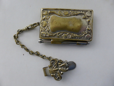
Artefact, Silver plate note pad, Early 20th century
This note-pad and holder perhaps belonged to Jessie Bell whose name is written on the first page. There are several entries on the pages and the dates range from 1908 to 1929. The entries include references to a Banquet for Mr J. Duffus, Purnim, 1912, Jack Ross’ Wedding Party, Dennington, 1912, R.J. Jones’ Dance, Woolshed, 1928 and Leila Jenkins’ 21st Birthday Party, 1928. This notebook and holder is of interest because it is an example of the type of appointment book used by the more affluent in the early 20th century. This is a heavily-embossed silver note-pad holder with a hinged lid on the front and clips at the side to hold a pencil. The writing material inside the pencil is missing. The back of the holder has a blank space in the middle where a name can be inscribed. At the top of the holder is a ring, holding a chain with an ornamented clip at the end. This enables the holder and pad to be hooked over a belt or lapel. Inside the holder are fifty paper pages on which to write appointments or notes. The pages are gilt-paged. The paper contains several notes handwritten in pencil re dances, parties etc. First Page: ‘Jessie A. Bell, Warrumyea, Wangoom, Warrnambool’ jessie bell, appointment book, warrnambool history -
 Warrnambool and District Historical Society Inc.
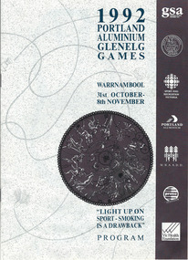
Programme - Glenelg Games 1992, 1992
This is a program for the events held in the 1992 Glenelg Games. These were held annually and began in 1982. The activities in 1992 included swimming, softball, ballroom dancing, surfing, tennis, shearing, go carting and croquet. The Games are organized by the Glenelg Sports Assembly, a regional body with representatives of sporting clubs, local government and interested individuals. The Assembly aims to promote sport in the Glenelg Region and hosts and organizes a number of other activities as well as the annual Games. This program is of interest as it demonstrates the number and range of activities that were included in the Glenelg Games of 1992. This is a booklet of 12 stapled pages. It contains, photographs, a programme of events, a map of Warrnambool, a Chairman’s Message and advertisements. The printing material is in black, blue and yellow tonings. Front Cover: ‘1992 Portland Aluminium Glenelg Games, Warrnambool, 31st October-8th November, Light Up on Sport- Smoking is a Drawback, Program1992 glenelg games, glenelg sports assembly, glenelg sports region, glenelg games -
 Warrnambool and District Historical Society Inc.
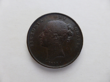
Coin, English Penny Victoria Det Gratia 1854, 1854
English currency before decimalisation in the 1970's consisted of pounds, shillings and pence with twelve pennies to the shilling and twenty shillings to the pound.Coins ranged from farthings which were one quarter of a penny through to pennies, threepence, sixpence, shillings ,half crowns and crowns. Most coins had a variety of common names such as a " bob" for a shilling a "quid for a pound and a tanner for a sixpence. This coin is the equivalent of five shillings and is known as a crown. The text around the obverse, "Victoria Dei Gratia 1844". On the reverse the text of Reg Fid Def"Britanniar translates as Queen of Britain and defender of the faith. This coin is one of the smaller denominations.A common currency coin which has social and historical significance.Round copper coin with flat edge. The The obverse has an image of the young Victoria with text around the edge.The reverse has an image of Brittania in a chariot.Dotted edge around the inside rim of both sides.BRITTANNIAR REG FID DEFon the reverse and Victoria Dei gratia on the obverse.english penny, 1854 penny -
 Warrnambool and District Historical Society Inc.
Numismatics, Coin :English Crown 1844, 1844
English currency before decimalisation in the 1970's consisted of pounds, shillings and pence with twelve pennies to the shilling and twenty shillings to the pound.Coins ranged from farthings which were one quarter of a penny through to pennies, threepence, sixpence, shillings ,half crowns and crowns. Most coins had a variety of common names such as a " bob" for a shilling a "quid for a pound and a tanner for a sixpence. This coin is the equivalent of five shillings and is known as a crown. The text around the obverse, "Victoria Dei Gratia 1844". On the reverse the text of Regina Fid Def"Britanniarum translates as Queen of Britain and defender of the faith.The text around the edge, DECUS ET TUTAMEN ANNO REGNI VIII translates as " an ornament and a safeguard. Coins were thus stamped in an effort to reduce the incidence of penny pinching whereby small amounts of precious metal were shaved from the edge of coins and still passed as full value coins.This coin was minted in the eighth year of the reign of one of England's longest ruling monarchs.It is of historical and social significance with the study of coins having considerable interest for many people. Large silver coin with image of Queen Victoria on the obverse or heads side of the coin and a coat of arms with crown at the top surrounded by a wreath of leaves is on the reverse. Text is around the edge of both sides with text also stamped into the edge of the coin as well. Obverse " Victoria Dei Gratia 1844." Reverse "Regina Fid Def"Britanniarum"On edge of coin is "DECUS ET TUTAMEN ANNO REGNI VIII english coins, coin half crown, english coin crown, warrnambool -
 Kiewa Valley Historical Society
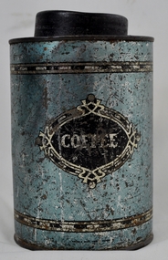
Tin Coffee Cylindrical, circa mid to late 1900's
This "coffee" tin has by the "art deco" appearance its origins in the late 1950's to 1960's. This time period was one of accelerated growth both in the physical (housing) sense and the mental (new ideas and inventions) changes in "attitudes". These occurred more rapidly in cities but had its effects on the rural environment. The drinking of coffee was spurred on by easier distribution of imported food and drinks. Advertising by stronger radio links and then by television brought the variety of foods and drinks to semi isolated rural regions. The accessibility through greater information channels becoming available brought with it unbelievable ranges of goods and foodstuffs. Rural regions still relied on bulk supplies and relatively larger storage containers than those in cities. This "bulk" buying and storage "syndrome" was a lingering result of many years of "drought" periods when road transports met delays from flooded roadways in supplying population centres in the Kiewa Valley. The construction phases in building the SEC Vic Hydro electricity Scheme in the eastern sections of the Victorian Alps brought many changes to the quiet rural regions in the Kiewa Valley. Changes in population and social mores. The influx of a varied , mostly temporary, and "European flavoured cuisine" changes the "cuppa tea only" flavour to the have a "coffee break". The subliminal influence of the "American" films changed those children growing up in the post 1950s from the "English tea" to the "American coffee". This "Americanisation process has influenced not only rural Australia but also other areas throughout the world.This "insignificant" coffee tin is very significant as it demonstrates that the Kiewa Valley was becoming more accessible to reliable coffee supplies and general food items.The container was part of a "set" of containers that included tea, sugar,biscuits,flour, rice and other family condiments. This type of kitchen storage containers was brought about through changing patterns in tea and coffee useage and overall consumption. Household demands for faster "self help" cooking especially beveridges and the greater choice of kitchen "utensils" was brought on by easier access to products due to a lessening of the area's "isolation" by having a reliable (all weather) road system and an ever increasing population growth. The need for travelling goods/merchant supply caravans to service the area became a diminishing factor, as a result of the establishment of grocery stores in Tawonga and Mount Beauty in the supply of previously "hard to get" groceries. This transition was precipitated by the SEC Vic Hydro Scheme of the 1940's to 1960's which increased the valley's population level three fold.This cylindrical tin has a pull/push lid(for easy access to the contents). The container is labelled for "coffee" however it has no commercial manufacturer's label to establish that it was bought with coffee ingredients in it. The majority of the container's external surface has a "metallic" light blue colour with two sets of silver rings confining black (horizontal spotted) rectangles. "COFFEE" within an elongated spherical "art deco" four pointed banner of silver and black colouringkitchen containers, domestic food storage, bulk stocks of dried condiments -
 Warrnambool and District Historical Society Inc.
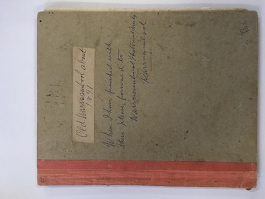
Book, Picturesque Warrnambool, C1891
This book presents a pictorial and written record of Warrnambool in 1891.It covers a wide range of topics. It provides statistical evidence relating to public buildings and organisations of that era, as well as basic information about district points of interest. The Mechanics Institute, the Common, Albert Park, the rivers, the Museum and the Sea Baths are all mentioned. The various drawings and advertisements provide a list of businesses which were prevalent at the time.As this book is one of only two complete copies documented to be still in existence, it is of considerable significance and importance to our collection. The drawings and text are artistically very much of the era and are aesthetically pleasing.Plain grey card cover with fabric binding. Handwriting on front cover and inside front cover. It contains a number of black and white and coloured plates depicting scenes of Warrnambool and the district. Approximately 70 pages.Old Warrnambool about 1891 hand written on label on front cover, underneath is also written “When I have finished with these please forward to Warrnambool Historical Society Warrnambool. D 77, 252 in bottom RHC of cover. picturesque warrnambool,, warrnambool 1891, -
 Warrnambool and District Historical Society Inc.
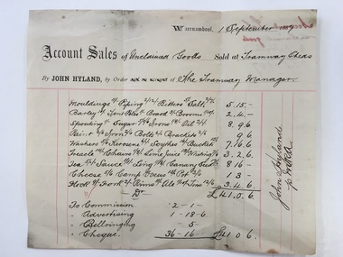
Docket, Hyland/ Tramways Sheds, Circa 1887
In 1858 a tramway was constructed to move goods between Warrnambool township and jetty on Lady Bay. It was established on the south side of Merri St in the approximate site of the present railway station. Large stores were also built near where the present rail lines to hold produce. This docket relates to unclaimed goods and range from tent poles, brooms, sugar scythes, lime juice tea, sauce, camp ovens and ale. John Hyland was the manager who was later mayor of Warrnambool. The Warrnambool tramway was an important part of transportation of goods in the 19th century from the port to the township which was over a mile away. White docket with some text printed in black with other sections handwritten in black pen. Dated September 1887. It shows a list of varied items. Signed John Hyland. “Account sales unclaimed goods by J Hyland Sep 1887” is in red pen on the back. warrnambool, warrnambool tramways, john hyland, unclaimed goods, -
 Warrnambool and District Historical Society Inc.
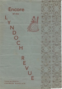
Document, Lyndoch Revue, C1950
This is a program for a local theatrical performance. It was produced and directed by Frances Sinclair and contains a number of dance and musical items. There are a number of local Warrnambool names among the performers such as K T Swinton, Rex Fotheringham, Mavis MacDonald, Miss Rooney, W Goodall, John Reid, George and June Philpot. The dancers ranged from tiny tots, Petite ballerinas, Corp de ballet to the belles De Paris. Some of the other items on the program are the Scottish Samba, Tut and Khamen and Fiesta in Granada by Ferdinande Del Campo Caravani111 and Monty Bellow the Atomic Bull & Co which would suggest that it around the time of the Atomic testing in the Montebello Islands in the 1950’s. A program which shows the artistic side to the city and associated humour and talent. It has a large number of names of those involved in the production and performance and would be typical of concerts performed around the country at that time. It predates the Warrnambool Theatre company which commenced production of musical items in the 1960’s.Dusty blue paper with red text running at an angle down the front cover. Diagram of a lady sitting and stitching. Brown floral border down the edge of the front and middle page. Back cover is plain apart from printer’s name on bottom centre.Kaye & Sons Printers Warrnambool. -
Warrnambool and District Historical Society Inc.
Domestic object - Recipe Book, Circa 1920
... Street (south of Merri St) Warrnambool great-ocean-road .1 ....1 Recipes ranging from ginger beer, rumbled eggs, cauliflower soufflets, fish souffle, orange marmalade, cakes and puddings. Also includes some household hints and a knitting pattern for a baby's jersey. Hand written in ink , arranged randomly. Reference to Noorat and some names. An early example of favourite recipes collected and handwritten in an exercise book. This is a practice which continues to this day..1 Black covered exercise book with handwritten recipes includes .2 Pink covered, printed booklet. Recipes given by Mrs. Wicken at Cookery Class Warrnambool April 1888 stuck on inside cover facing page.non-fiction.2 R.A. Phillips Bookseller Warrnambool; Thomas Smith Printer Warrnamboolrecipes, household hints, knitting patterns, noorat, warrnambool, mrs wickens recipes -
 Warrnambool and District Historical Society Inc.
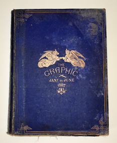
Book, Edward Joseph Mansfield, London, The Graphic Jany to June 1887, 1887
A bound copy of a British magazine which was published weeklyThe royal blue front hard cover has gold scroll work around the edges and an embossed image of two flying angels representing the arts and literature. It also has an image of a quill and a paint brush and gold printing. The cover is stained and is frayed around the edges. The spine has embossed symbols and printing and has been mended with adhesive tape on the inside. The title on the spine is _The Graphic Illustrated Newspaper Vol 35 Jany to June 1887 London 90 Strand. The pages are gilt edged and contain copies of the weekly paper commencing January first. There are black and white and coloured illustrations. The frontispiece has a covering piece of badly torn tissue.fictionA bound copy of a British magazine which was published weekly vintage magazines, the graphic, the graphic 1887, warrnambool -
 Warrnambool and District Historical Society Inc.
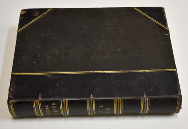
Book - Encyclopedia of Technical Education, Cassell, Petter and Galpin, The Technical Educator Volume 3 -4, Late 19th Century
Encyclopedia of Technical Education.Two volumes with technical information on a wide range of subjects.This is a book of 428 pages. The cover has brown composite material with a leather spine and corners. The spine has gold lettering and gold ridged lines. The corners are somewhat tattered. The title page and some other pages are torn. The pages contain printed text, black and white diagrams and sketches and colour illustrations.non-fictionEncyclopedia of Technical Education.Two volumes with technical information on a wide range of subjects. technical education, technical school text book, warrnambool -
 Warrnambool and District Historical Society Inc.
Administrative record - Warrnambool Waterworks Newspaper Cuttings, 1891 to 1917
This ledger contains newspaper cuttings form The Warrnambool Standard newspaper from May 1891 to October 1917. The cuttings are reports of meetings of the Warrnambool Waterworks Trust. In the early days of Warrnambool domestic water and water for fire suppression was supplied by tanks, wells and springs. In the 1870s various schemes were proposed to find a better supply of water. In 1891 the Warrnambool Waterworks Trust was formed using water from the Merri River. This system lasted until 1939 when the Warrnambool water supply came from the Otway ranges. This system is still the water supply for Warrnambool today. The cuttings in this ledger will be useful for research.This is a ledger with a brown mottled cover and a leather spine and leather corners. The spine is partly detached. The front cover has a label pasted on it. The pages originally had hand written entries (The Minutes of a Warrnambool organisation). Newspaper cuttings have been pasted over the original writing. Warrnambool Waterworks Trust Newspaper Reports From 19th May 1891 To --- warrnambool waterworks trust, warrnambool water supply