Showing 3242 items matching "road maps"
-
 Eltham District Historical Society Inc
Book, Melway Great Melbourne street directory including Geelong, Phillip Island Healesville, Bellarine & Mornington Peninsulas, 1998
... information, South east Australia tours maps, Vic Roads new route..., South east Australia tours maps, Vic Roads new route numbers ...25th edition. Coloured detailed maps accessed by a street or location index. Cover: (Includes) New Southbank map including Crown Complex, enlargements of Footscray and Kensington, bike paths, walking tracks & horse trails, latest public transport information, South east Australia tours maps, Vic Roads new route numbers, map of Australia1 atlas (22, 772 p.) : col. maps ; ISSN 03113957streets, maps, roads, melbourne -
 Whitehorse Historical Society Inc.
Pamphlet, Information Bulletin, 1/12/1993
... Road to go ahead. Map showing location and history of project... and Springvale Road to go ahead. Map showing location and history ...Freeway Extension between Doncaster Road and Springvale Road to go ahead.Freeway Extension between Doncaster Road and Springvale Road to go ahead. Map showing location and history of project given.Freeway Extension between Doncaster Road and Springvale Road to go ahead. freeways, doncaster road, doncaster, springvale road, nunawading, vicroads, city of nunawading, city of camberwell, city of box hill, city of ringwood -
 Bendigo Historical Society Inc.
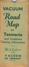
Document - BILL ASHMAN COLLECTION: VACUUM MAP OF TASMANIA
... Vacuum Road Map of Tasmania and Complete Touring...Vacuum Road Map of Tasmania and Complete Touring... Bill Ashman Collection - Correspondence Vacuum Road Map ...Vacuum Road Map of Tasmania and Complete Touring Information with the Compliments of the Vacuum Oil Company Pty Ltd. Coloured map of Tasmania with trucks, aeroplane, oil bottles and petrol bowsers in the margins. Alphabetical Index of Towns, Lakes, Mountains, Bays, Capes, etc., with key and Licensed Public Aerodromes in Tasmania and Their Location. On the back is Outlets of Hobart, Outlets of Launceston, What to See in Hobart, Beauty Spots and Tourist Information, What to See in Launceston, Vacuum Products, Traffic Hints, Super Plume or Plume, Making Sure of a Trouble-Free Trip and the front cover picture of a lady, child and a man in their car at the petrol bowser. Map folds up and is kept in a light green folder.map, bill ashman collection - correspondence, vacuum road map of tasmania and complete touring information, vacuum oil company pty ltd -
 Bendigo Historical Society Inc.
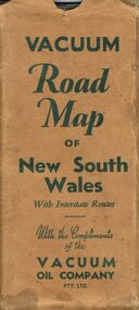
Document - BILL ASHMAN COLLECTION: VACUUM ROAD MAP OF NEW SOUTH WALES
... BILL ASHMAN COLLECTION: VACUUM ROAD MAP OF NEW SOUTH WALES... Vacuum Road Map of New South Wales...Vacuum Road Map of New South Wales with Interstate Routes... Bill Ashman Collection - Correspondence Vacuum Road Map of New ...Vacuum Road Map of New South Wales with Interstate Routes with the Compliments of the Vacuum Oil Company Pty. Ltd. Coloured map of NSW with car, trucks, aeroplane and petrol bowsers around the margin. Has a list of principal Towns and Distances from Sydney. On the back is Beauty Spots around Sydney, Traffic Hints, Sydney-Melbourne Routes, Short Tours Around Sydney, Outlets of Sydney, Canberra and Newcastle, What to See in Sydney, Vacuum Products, Making Sure of a Trouble-Free Trip, Super Plume or Plume and the front picture of the folded map which has a car with a lady, child and a man at the petrol bowser. Map folds up and has a brown card pocket to keep it in.map, bill ashman collection - correspondence, vacuum road map of new south wales, vacuum oil company pty ltd, clive barass -
Ringwood and District Historical Society
Leaflet, Chris A. Moule, Auctioneer, Pamphlet produced for a builders realisation sale of lets in Manuela Terrace and Lyn Court Ringwood 1979, 1979
... in the "Bel-Air" Estate marked between Glenvale Road and Oban Road... and Oban Road on diagrammatic map of Ringwood. Single page double ...Pamphlet produced for a builders realisation sale of lets in Manuela Terrace and Lyn Court Ringwood 6th December 1979 in the "Bel-Air" Estate marked between Glenvale Road and Oban Road on diagrammatic map of Ringwood.Single page double-sided leaflet, black printing, front has red border. +Additional Keywords: Moule, C.A. -
Port Melbourne Historical & Preservation Society
Map - Road plans for Fishermens Bend, R S Atkinson, 30 Apr 1946
... CRB Map outlining road plans for Fishermens Bend... fishermans bend CRB Map outlining road plans for Fishermens Bend ...CRB Map outlining road plans for Fishermens Bend and including the site of the Commonwealth Aircraft Corporation, Aerodrome, General Holdens and C.S.R.I., 1946transport - aviation and aerodrome, industry - manufacturing, fishermans bend -
 Bendigo Historical Society Inc.
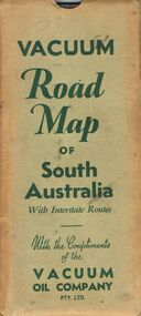
Document - BILL ASHMAN COLLECTION: VACUUM MAP OF SOUTH AUSTRALIA
... Vacuum Road Map of South Australia...Vacuum Road Map of South Australia with Interstate Routes... Bill Ashman Collection - Correspondence Vacuum Road Map ...Vacuum Road Map of South Australia with Interstate Routes with the Compliments of the Vacuum Oil Company Pty. Ltd. Coloured map of S.A. with car, trucks, aeroplane and petrol bowsers on the map. Map only shows the Southern half of S.A. On the back is Adelaide-Melbourne Routes, Traffic Hints, Eucla to Perth, Tours Around Adelaide, Acknowledgement to the Royal Automobile Association of South Australia, Inc., Darwin-Adelaide Routes, Outlets of Adelaide, Vacuum Products, What to See in Adelaide, Super Plume Ethyl, Making Sure of a Trouble-Free Trip, and the front cover. Also folded in the map is a small map from Hancock's Garage, Kingston with routes from Melbourne to Adelaide and distances. On the back is an advertisement for Hancock's Garage and a map of Kingston. Map folded and kept in a light green cover.map, bill ashman collection - correspondence, vacuum road map of south australia, vacuum oil company pty ltd, commissioner of crown lands for south australia, royal automobile association of south australia, inc. -
 Ballarat Tramway Museum
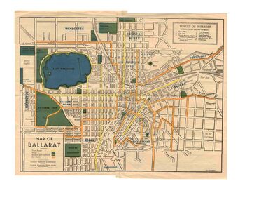
Map, Greater Ballarat Association and George Netherway, "Map of Ballarat", c1945
... diagrammatic and is not entirely to scale. On rear is a road map.... On rear is a road map of the Ballarat area, lists of statistics ...Yields information about Greater Ballarat, including trams, buses, locations and streets. Has a strong association with George Netherway.Five colour map of Ballarat, showing streets, places of interest, Parks, tram routes, bus routes, railway lines, prepared by G. C. Netherway, Greater Ballarat Association, for the Victorian Government Tourist Bureau, Ballarat Branch, c1945. Shows suburbs names, location of orphanage, the lack of development north of Howitt St, in Wendouree. Map is part diagrammatic and is not entirely to scale. On rear is a road map of the Ballarat area, lists of statistics, beauty spots, look outs, art and culture, points of historical interest, industrial products and recreation. Note: Image 1, assembled from four scans, does not entirely match at edges. See Reg item 2074 for photographic image of another version map. See Reg Item 5613 for another version of this map. trams, tramways, ballarat, tram routes, bus routes, map, lists -
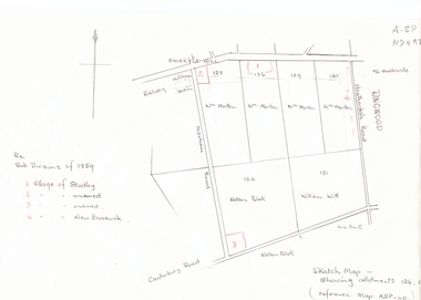 Whitehorse Historical Society Inc.
Document, Subdivisions 1859, nd
... of Canterbury and Mitcham Roads. Refer map A - SP 110.... East corner of Canterbury and Mitcham Roads. Refer map A - SP ...Sketch map of subdivisions of 1859.Sketch map of subdivisions of 1859. Allotment 126 and portions of 125, 126 and 130, including 'Village of Studley', 'Village of New Brunswick' and two unnamed. Information from Mr McComb, retired surveyor; sketch and notes. Areas near railway line east of Mitcham Station and North East corner of Canterbury and Mitcham Roads. Refer map A - SP 110.Sketch map of subdivisions of 1859.land subdivision, heatherdale road, mitcham, purches street, mitcham road, vermont, canterbury road, whitehorse road, brunswick road, creek road, centre road, studley village, new brunswick village -
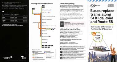 Melbourne Tram Museum
Pamphlet, Public Transport Victoria (PTV), Buses replace trams along St Kilda Road and Route 58, Oct. 2022
... Pamphlet - Buses replace trams along St Kilda Road...Melbourne Tram Museum 8 Wallen Road Hawthorn melbourne ...Pamphlet - Buses replace trams along St Kilda Road and Route 58 - issued for the track relocation at Domain Junction / Anzac station during the period 27-11-2022 to 17-12-2022. Actual work took a day longer due to weather. Similar pamphlets would have been issued for other routes that used St Kilda Road. Includes maps, alternative routes. Issued by Public Transport Victoria. Part of the Metro tunnel works.Yields information about the reconstruction of Domain Junction for the future Anzac station.Pamphlet - four fold DL - full colour on semi gloss paper. Two copies held.tramways, route 58, anzac station, domain interchange, track work, bus replacement -
Stawell Historical Society Inc
Document - Report, Nicole Start, Conservation Status of Roadsides in the Shire of Stawell, 1991
... , Grazing, Cropping, Gravel, Noxious weeds, Firebreaks, Road Design..., Grazing, Cropping, Gravel, Noxious weeds, Firebreaks, Road Design ...Covers: Shire, roadsides, Assessment: Species, Flora, Grazing, Cropping, Gravel, Noxious weeds, Firebreaks, Road Design. With loos maps X 2 in back. Author Nicole StartPlastic Front Cover. Yellow Paper with Photo of a country road.Nicole Start Biological and Chemical Sciences Ballarat University Collage December 1991 -
 Whitehorse Historical Society Inc.
Document - Map, Roads, 1932
... Map of roads on which Country Roads Board funds were spent... Shire of Blackburn and Mitcham Terrara Road Vermont Map of roads ...Map of roads on which Country Roads Board funds were spent, with request and response by Shire of Blackburn and Mitcham to the Country Roads Board, July - August 1932.roads and streets, victoria. country roads board, shire of blackburn and mitcham, terrara road, vermont -
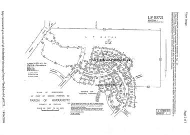 Ringwood and District Historical Society
Document - Subdivision Plan, LP83721 - Part of Crown Portion 23, Parish of Warrandyte, County of Evelyn - 1969
... Two A4 maps of residential subdivision off Wonga Road...Two A4 maps of residential subdivision off Wonga Road ...A4 LANDATA Land Victoria plan printout dated 2009Two A4 maps of residential subdivision off Wonga Road, Ringwood. Enlargement map includes Holyrood Crescent, Berkley Road, Carmen Court, Frederic Drive, Kenwood Crescent, Marilyn Street and Adele Court. -
 Bacchus Marsh & District Historical Society
Map, Gaynor Street Area Land Sales, Maddingley, 1888
... , Typpynge Street, Finn Street and East Maddingley Road. . The map... Street and East Maddingley Road. . The map is pasted ...This map was produced for a major sale of land in the Maddingley area of Bacchus Marsh in 1888. The sale was conducted by two firms from Melbourne, Carney and Kelly 12 Swanston Street Melbourne. and 'Richardson, Kerr & Co. 40 Flinders Lane Melbourne. 136 blocks were for sale.A single page paper map showing land allotments for sale in the Maddingley area of Bacchus Marsh. Locations shown include Gaynor Street, Maddingley Road South, Parwan Road, Mitchem Street, Typpynge Street, Finn Street and East Maddingley Road. . The map is pasted into a bound volume containing 76 maps or plans in total. High resolution digital image stored on BMDHS computer network. bacchus marsh victoria maps, maddingley victoria maps, land use, maddingley victoria history, land sales bacchus marsh, land sales maddingley -
 Bacchus Marsh & District Historical Society
Map, Gaynor Street Land Sales, Maddingley, circa 1880s-1890s
... , Typpynge Street, Finn Street and East Maddingley Road. . The map..., Typpynge Street, Finn Street and East Maddingley Road. . The map ...This map was produced for a major sale of land in the Maddingley area of Bacchus Marsh. The precise date of the sale has not been determined. Features present on the map such as the Bacchus Marsh Railway Station indicate the land sale must have taken place some time after 1887 when the Railway Station opened. A single page paper map showing land allotments for sale in the Maddingley area of Bacchus Marsh. Locations shown include Gaynor Street, Maddingley Road South, Parwan Road, Mitchem Street, Typpynge Street, Finn Street and East Maddingley Road. . The map is pasted into a bound volume containing 76 maps or plans in total. High resolution digital image stored on BMDHS computer network. bacchus marsh victoria maps, maddingley victoria maps, land use, maddingley victoria history, land sales bacchus marsh, land sales maddingley -
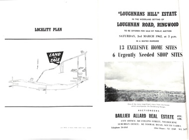 Ringwood and District Historical Society
Document - Folder, Subdivision Auction - Loughnans Hill Estate 1962, Ringwood, Victoria
... Court and 6 shop sites in Loughnan Road, with map of subdivision... in Loughnan Road, with map of subdivision, terms of sale, and summary ...Double-sided bifold page advertising auction on Saturday 3rd March, 1962 - 13 residential allotments in Hearthside Court and 6 shop sites in Loughnan Road, with map of subdivision, terms of sale, and summary of features and services. Adjoining service station shown on accompanying Plan of Subdivision - Part of Crown Allotment 28 Parish of Warrandyte, also showing location of property known as "Hearth", hence Hearthside Court.Auctioneers - Baillieu Allard Real Estate Pty Ltd., 360 Collins Street, Melbourne, and 302 Toorak Road, South Yarra. Telephone 24-4365, After hours XU1549, WL2471. -
Whitehorse Historical Society Inc.
Document, Municipal Chambers, Nunawading, 23/07/2001 12:00:00 AM
... Whitehorse Road, Nunawading, and of 13 Walkers Road, Nunawading... Road, Nunawading. Includes maps, plans, photos ...Papers relating to applications for Council permits, objections and VCAT hearingsPapers relating to applications for Council permits, objections and VCAT hearings concerning development of 360-362 Whitehorse Road, Nunawading, and of 13 Walkers Road, Nunawading. Includes maps, plans, photos and architectural assessment of 360 Whitehorse Road by Andrew Ward.Papers relating to applications for Council permits, objections and VCAT hearings associated planning consultants, arrowsmith, valda, nunawading and district historical society, municipal chambers, whitehorse road, nunawading, no 360, no 362, walkers road, no. 13, victorian civil and administrative tribunal, ward, andrew, city of whitehorse -
 Anglesea and District Historical Society
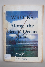
Book, J Loney, Wrecks Along the Great Ocean Road, 1967
... along the Great Ocean Road. Illustrated with both maps... Road. Illustrated with both maps and photographs ...Book first published in 1967 dealing with the shipwrecks along the Great Ocean Road. Illustrated with both maps and photographs and with a chrononolgy of the list of wrecks from pre-1800 through to 1958.Title: WRECKS / Along the / Great Ocean / Road J.K. LONEYjack loney, dewey no 910.453, book -
 Ringwood and District Historical Society
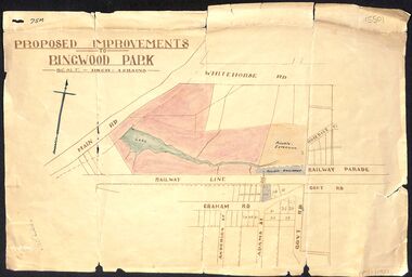
Map, Proposed Improvements to Ringwood Park (Ringwood Lake) dated 14 January 1927
... is incorrectly labelled Whitehorse Road. The map shows Rosedale Crescent... Dandenong Road is incorrectly labelled Whitehorse Road. The map ...Proposed Improvements to Ringwood Park (Ringwood Lake) dated 14 January 1927, signed Cr McCaskill. Main Road is Whitehorse Road (Maroondah Highway), and Mt Dandenong Road is incorrectly labelled Whitehorse Road. The map shows Rosedale Crescent and Railway Parade, both of which exist in 2024. On the bottom of the map, south of the railway line, showing proposed streets - Graham Road, Anderson Street and Adams Street - in preparation for the sale of the Theo Anderson property. That area is now Bedford Park. -
 Kew Historical Society Inc
Map, MMBW, MMBW Plan No.66 Kew, 1900-1910
... by Burke Road. The map shows the extent of urban development... Road, and in the east by Burke Road. The map shows the extent ...The Melbourne and Metropolitan Board of Works (MMBW) was established by an act of the Victorian Parliament in 1890 to prepare for and to implement a sewerage and water reticulation system across what was then inner Melbourne, its surrounding and middle distance suburbs, including Kew. The MMBW was disbanded in 1991.The map collection of the Kew Historical Society has at its core the historic maps assembled and originally stored in the City Engineer's Department of the City of Kew. These include maps in a number of scales. The vast majority of maps were produced by the MMBW in the first two decades of the twentieth century, and are solid working maps, backed by linen for durability. These maps are historically significant to Kew, the City of Boroondara and to the history of the development of state utilities in Victoria. A number of the Kew maps have additional details added by former municipal officers, including the levels reached by various floods. As these were working documents, information was added to them long after the period of their initial production and distribution.Early map of part of the Borough of Kew, created in the first decade of the twentieth century, at a scale 160 ft to 1 inch. The map covers what was then the south eastern part of Kew, bordered on its north by Adeney Avenue, in the west by Sackville Street, in the south by Barkers Road, and in the east by Burke Road. The map shows the extent of urban development by that time, prominent institutions and the outlines of built structures in the municipality. Contour lines were added in ink to the map at a later stage.MELBOURNE AND METROPOLITAN BOARD OF WORKS / PLAN NO. 66 / KEW melbourne & metropolitan board of works, mmbw maps, mmbw plans, borough of kew, cartography -
 Melbourne Tram Museum
Photograph - Digital Image, Public Transport Victoria (PTV), "Buses replace trams - route 58", Oct. 2020
... , map and road closures.... Park. Has details on the bus replacement services, map and road ...Digital Image of a pamphlet "Buses replace trams - route 58", November and December 2020 for the reconstruction of the tram track through Royal Park. Has details on the bus replacement services, map and road closures.trams, tramways, royal park, trackwork, track -
Port Melbourne Historical & Preservation Society
Flyer, Suggested ring road around Port, 2018 - 2019
... in community. . Flyer regarding proposed ring road around Port... road around Port Melbourne. Map of proposed route and listing ...These items were collected by a PMHPS member during 2018-19 and they have been retained as a group of ephemeraVarious ephemera of local interest showing changes in community. . Flyer regarding proposed ring road around Port Melbourne. Map of proposed route and listing key contact people. Campaign by Social Media Realty.built environment, ring road, social media ready -
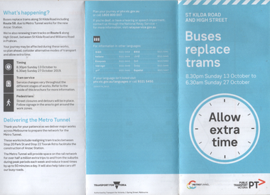 Melbourne Tram Museum
Pamphlet, Public Transport Victoria (PTV), "Buses replace trams - St Kilda Road and High Street", Oct. 2019
... Pamphlet - "Buses replace trams - St Kilda Road and High...Melbourne Tram Museum 8 Wallen Road Hawthorn melbourne ...Pamphlet - "Buses replace trams - St Kilda Road and High Street" - part of the Metro tunnel project works, Oct 2019 affecting mainly route 6 trams along with St Kilda Road routes. Includes a map of the work zone and bus replacement services.Demonstrates a passenger information document about trackworks.Pamphlet - 6 fold DL printed trams, tramways, st kilda road, high st, route 16, metro tunnel, trackworks -
 Kew Historical Society Inc
Map, MMBW, MMBW Plan No.67 Kew, 1900-1910
... by High Street, and in the east by (about) Belford Road. The map... by (about) Belford Road. The map shows the extent of urban ...The Melbourne and Metropolitan Board of Works (MMBW) was established by an act of the Victorian Parliament in 1890 to prepare for and to implement a sewerage and water reticulation system across what was then inner Melbourne, its surrounding and middle distance suburbs, including Kew. The MMBW was disbanded in 1991.The map collection of the Kew Historical Society has at its core the historic maps assembled and originally stored in the City Engineer's Department of the City of Kew. These include maps in a number of scales. The vast majority of maps were produced by the MMBW in the first two decades of the twentieth century, and are solid working maps, backed by linen for durability. These maps are historically significant to Kew, the City of Boroondara and to the history of the development of state utilities in Victoria. A number of the Kew maps have additional details added by former municipal officers, including the levels reached by various floods. As these were working documents, information was added to them long after the period of their initial production and distribution.Early map of part of the Borough of Kew, created in the first decade of the twentieth century, at a scale 160 ft to 1 inch. The map covers what was then the north central part of Kew, bordered on its north by the Outer Circle Railway Spruzen and Beresford Avenues, in the west by Princess Street, in the south by High Street, and in the east by (about) Belford Road. The map shows the extent of urban development by that time, prominent institutions and the outlines of built structures in the municipality. Contour lines were added in ink to the map at a later stage.MELBOURNE AND METROPOLITAN BOARD OF WORKS / PLAN NO. 67 / KEW melbourne & metropolitan board of works, mmbw maps, mmbw plans, borough of kew, cartography -
 Kew Historical Society Inc
Map, MMBW, MMBW Plan No.68 Kew, 1900-1910
... Early map of part of the Borough of Kew, created... and Burke Road. The map shows the extent of urban development ...The Melbourne and Metropolitan Board of Works (MMBW) was established by an act of the Victorian Parliament in 1890 to prepare for and to implement a sewerage and water reticulation system across what was then inner Melbourne, its surrounding and middle distance suburbs, including Kew. The MMBW was disbanded in 1991.The map collection of the Kew Historical Society has at its core the historic maps assembled and originally stored in the City Engineer's Department of the City of Kew. These include maps in a number of scales. The vast majority of maps were produced by the MMBW in the first two decades of the twentieth century, and are solid working maps, backed by linen for durability. These maps are historically significant to Kew, the City of Boroondara and to the history of the development of state utilities in Victoria. A number of the Kew maps have additional details added by former municipal officers, including the levels reached by various floods. As these were working documents, information was added to them long after the period of their initial production and distribution.Early map of part of the Borough of Kew, created in the first decade of the twentieth century, at a scale 160 ft to 1 inch. The map covers what was then the north central part of Kew, bordered in the north by Oak Avenue, in the west by the Yarra River and Connor's Creek, in the south by Beresford and Carnegie Avenues, and in the east by Glass's Creek and Burke Road. The map shows the extent of urban development by that time, prominent institutions and the outlines of built structures in the municipality. Contour lines and the levels of historic floods were added in ink to the map at a later stage.MELBOURNE AND METROPOLITAN BOARD OF WORKS / PLAN NO. 68 / KEW melbourne & metropolitan board of works, mmbw maps, mmbw plans, borough of kew, cartography -
Melbourne Tram Museum
Ephemera - Timetable, Melbourne & Metropolitan Tramways Board (MMTB), "New Bus services Footscray - Sunshine and Footscray - Moonee Ponds", Original 1936
... either Maribyrnong Road or Ascot Vale Road. Includes a map... or Ascot Vale Road. Includes a map and a magazine or newspaper item ...Set of three A4 sheets from photocopies collected by Keith Kings about the provision of bus services from Footscray, with services commencing 6/12/1936. Details the timetable for services from Footscray - Sunshine and Footscray - Moonee Ponds via either Maribyrnong Road or Ascot Vale Road. Includes a map and a magazine or newspaper item.trams, tramways, footscray, buses, moonee ponds, sunshine -
 City of Kingston
Pamphlet - Colour, Farrow Falcon Press, Printers, Ozone Estate, Bluff Road, Hampton, c.1940
... Estate, Bluff Road Hampton. Incorporates a map of the estate... Estate, Bluff Road Hampton. Incorporates a map of the estate ...Sales plan for land in the suburb of Hampton (Highett), bounded by Bluff Road, Wickham Road, Peterson Street and June Street. Includes Morley Street, Follett Avenue, and Parrett StreetThe developing urban area of Highett within the City of Kingston. This land sale pamphlet illustrates the subdivision of land within the municipality and the changing demographic of the district as new houses are constructed close to infrastructure.Colour pamphlet advertising for private sale the Ozone Estate, Bluff Road Hampton. Incorporates a map of the estate bordered by Bluff Road, Wickham Road, June Street and Peterson Street including Morley Street, Follett Avenue and Parrett Street.Handwritten in grey pencil on reverse: Ozone Printed in purple ink on front top right-hand corner: Vendors are - Leslie Harcourt MacGowan, Esq / Neerim Road, Caulfield / & / Arthur Alfred Parrett, Esq / 311 Flinders Lane / Melbourneland sales, estate, hampton, highett -
 City of Kingston
Pamphlet - Colour, Farrow Falcon Press, Printers, Ozone Estate, Bluff Road, Hampton, c. 1940
... Estate, Bluff Road Hampton. Incorporates a map of the estate... the Ozone Estate, Bluff Road Hampton. Incorporates a map ...Sales plan for land in the suburb of Hampton (Highett), bounded by Bluff Road, Wickham Road, Peterson Street and June Street. Includes Morley Street, Follett Avenue, and Parrett StreetThe developing urban area of Highett within the City of Kingston. This land sale pamphlet illustrates the subdivision of land within the municipality and the changing demographic of the district as new houses are constructed close to infrastructure.Colour pamphlet advertising for private sale the Ozone Estate, Bluff Road Hampton. Incorporates a map of the estate bordered by Bluff Road, Wickham Road, June Street and Peterson Street including Morley Street, Follett Avenue and Parrett Street.Handwritten in grey pencil on rear: Ozone Estateland sales, estate, highett, hampton -
 Bacchus Marsh & District Historical Society
Map, Bacchus Marsh Tuesday 23rd Oct. 1888, Lodge & Dunn's Paddocks 1888. Business and Mansion Sites
... along the Parwan Road in Maddingley. The map is pasted... Marsh Victoria Maps Maddingley Victoria Maps At bottom on left ...This map was created as a plan for an auction of land close to the Bacchus Marsh Railway Station. The auction took place on 23 October 1888. 102 allotments of land from an area known as Lodge and Dunn's paddocks was offered for sale. The auction was conducted by auctioneers based in Melbourne and was advertised in Melbourne newspapers as well as in the Bacchus Marsh Express newspaper. The auction plan contains a range of details including the selling agents, Munro and Baillieu; W.P. Lockhart; and John Turner, all of Melbourne, deposit terms for purchases, price of railway passes for a return trip from Melbourne to Bacchus Marsh of 1 shilling, and a description of the land as having 'magnificent views and perfect drainage'. A single page paper map showing allotments of land for sale along the Parwan Road in Maddingley. The map is pasted into a bound volume containing 76 maps or plans in total. High resolution digital image stored on BMDHS computer network. At bottom on left side: 'Harston & Co. Lith, Melb.'land sales bacchus marsh, land sales maddingley, bacchus marsh victoria maps, maddingley victoria maps -
 Bacchus Marsh & District Historical Society
Map, Bacchus Marsh Suburban Allotments Parwan Road Lodge & Dunn's Paddocks 1888
... along the Parwan Road in Maddingley. The map is pasted... for sale along the Parwan Road in Maddingley. The map is pasted ...This map was created as a plan for an auction of land close to the Bacchus Marsh Railway Station. The auction took place on 23 October 1888. 102 allotments of land from an area known as Lodge and Dunn's paddocks was offered for sale. A single page paper map showing allotments of land for sale along the Parwan Road in Maddingley. The map is pasted into a bound volume containing 76 maps or plans in total. High resolution digital image stored on BMDHS computer network. land sales bacchus marsh, land sales maddingley, bacchus marsh victoria maps, maddingley victoria maps