Showing 125 items matching "rock formations"
-
 Halls Gap & Grampians Historical Society
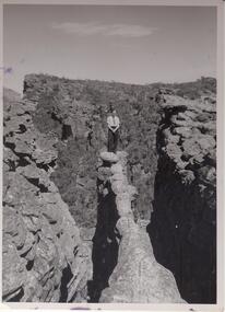
Photograph - B/W, C 1960s
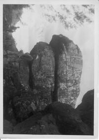
... . Large rock formations flank ledge on both sides. Peak... of a narrow,rocky ledge. Large rock formations flank ledge on both ...Photo is of the "Nerve Test", and is a ' Tourism promotion' photo taken by the Victorian railways.Photo shows man standing at end of a narrow,rocky ledge. Large rock formations flank ledge on both sides. Peak in background. Man is wearing dark pants with shirt and tie.Copyright photograph. This photograph may be reproduced on condition that it is acknowledged as Victorian Railways Photograph.scenery, wonderland range -
 Kiewa Valley Historical Society
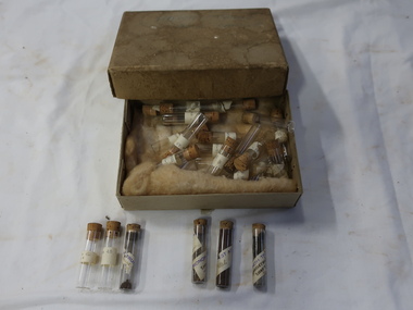
Sample Tubes
... of the rock formations and ground water.... of Geological investigation into the characteristics of the rock ...Part of Geological investigation into the characteristics of the rock formations and ground water.Water supply and infrastructure requires prior investigation before construction work can commence.Very small glass tubes (about 30) with cork toppers. Each tube is labelled. Resting on wool in a cardboard box with a lid. Stored in an old thick cardboard box with a very faint 'Harrietville ... Samples' on its lid.On the tubes - place and number "Harrietville / samples"geological samples, harrietville water -
 Stawell Historical Society Inc
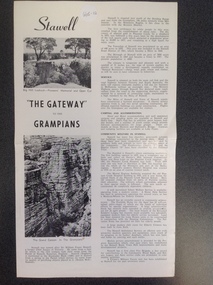
Book, Stawell "The Gateway to the Grampians", 1988
... Photograph which shows a rock formation known as The Grand Canyon... a rock formation known as The Grand Canyon. which is located ...Stawell Tourist InformationA Page folded in half to make 4 pages with large print and small print split into two columns as well as two photographs on the right side"Stawell" with Two photographs showing Pioneer's Lookout on Big Hill. " "The Gateway" to the Grampians" above the other Photograph which shows a rock formation known as The Grand Canyon. which is located in the Grampians.stawell tourism -
 Halls Gap & Grampians Historical Society
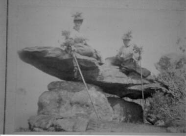
Photograph - Sepia
... Photo shows 2 women sitting on a rock formation, both... on a rock formation, both are wearing hats adorned with flowers ...The name " Balmain " has been attributed to the photo, James Balmain and his wife, Amy Sophia [D'Alton} purchased a vacant school cottage from the area and moved it to their land and called it Bellfield. Amy died at age 37, James returned to Scotland with their 3 children.Photo shows 2 women sitting on a rock formation, both are wearing hats adorned with flowers and appear to be wearing long skirts and high buttoned blouses. They are both holding sticks which seem to be decorated with flowers,recreation, bush-walking -
 Greensborough Historical Society
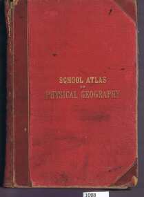
Book, W. & A.K. Johnston, School atlas of physical geography: the elementary facts of geology; hydrography; meteorology and natural history by Alex Keith Johnston, 1871_
... maps and various rock formations.... has 20 plates illustrating maps and various rock formations ...This atlas of physical geography has 20 plates illustrating maps and various rock formations.This volume illustrates a 19th century view of physical geography.51 pages, 20 plates, maps. Red hard cover with title in gold lettering.Inscribed on fly leaf with original owner's name (1890)physical geography, school books, atlases -
 Sunbury Family History and Heritage Society Inc.
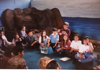
Photograph, School excursion
... rock formation.... and a reconstructed rock formation. School excursion Photograph ...The photograph was taken when students from Bulla Primary School were taken on an excursion to the Melbourne Aquarium as part of their science studies.The excursion to the Melbourne Aquarium was part of the student's science studies,A non-digital coloured photograph of a group of children seated on the floor listening to a person giving a talk. Some of them have notebooks and writing materials to take notes. behind them is a backdrop of an expanse of water and a reconstructed rock formation.bulla primary schooil, school excursions, melbourne aquarium, science -
 Flagstaff Hill Maritime Museum and Village
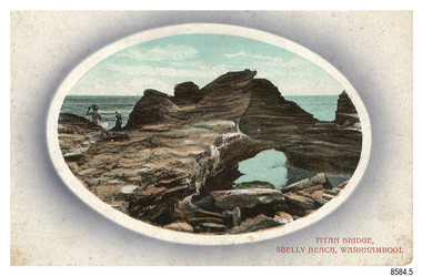
Postcard - Scenic, Warrnambool, Titan Bridge, Shelly Beach, Warrnambool, 1902-1929
... rock formation... to investigate and rock formations to climb. Joseph Jordan - Joseph... the sea on a rough rock beside a rock formation resembling... to investigate and rock formations to climb. Joseph Jordan - Joseph ...The nine postcards in this set were donated together and date to the early 1900s. All but one postcard in this set shows images of Warrnambool, in the Western District of Victoria; the other has a London image. The postcards were all printed in Great Britain according to that country’s postal regulations. The fronts of all cards have titles printed in red. Most of the images on the cards are attributed to photographer Joseph Jordan and belong to the Jordan Series. The back of these cards has an outline for a postage stamp, a vertical dividing line and a heading on each side of the line to separate the Correspondence from the Address. Postcards or ‘correspondence cards’ appeared in Britain in 1894. They were plain cards with a space for the message on one side and an address on the other; regulations didn’t allow anything but the address to be written on the ‘address’ side. In 1902 the British regulations then allowed a picture to be printed on the front and the address on the back, so messages had to be written on the picture side. Soon, the regulations changed and the back was divided for a message and the address. Titan Bridge, Warrnambool – The name Titan Bridge is likely to be a reference to the huge Titan crane that was used in the construction of the Breakwater in the late 19th century. Shelly Beach is a popular swimming area with the added attraction of rock pools to investigate and rock formations to climb. Joseph Jordan - Joseph Jordan was born in 1841 in Leicester England. When he was 16 he joined the 7th Queen's Own Hussars and was sent to India at the outbreak of the mutiny. He took part in the relief of Lucknow and remained in India for eleven years. It was during this time that he became interested in photography. He was posted to New Zealand and later came to Victoria, becoming a sergeant major of the Mounted Rifles. In the mid-1880s he came to the Western district where he was responsible for establishing units of the Mounted Rifles in various country towns such as Dunkeld, Mortlake, Panmure, Bushfield, Koroit etc. He resigned from the army in 1889 and set up a professional photography studio in Liebig Street, Warrnambool. He became very well known in the Western District for family photographs, official photographs of local councillors and groups as well as views of local scenery. In 1891 he photographed the wrecked barque ‘Fiji’ at ‘Wrecks Beach’ near Princetown. His business was taken over by his son Arthur around 1917. Joseph was a keen rifle shot and in 1924 he donated the "Jordan Shield" as a prize to the Victorian Rifle Association. He was made a "Life Honorary Member" of the Warrnambool Returned Soldiers League and in 1933 he was recognised as being the oldest living soldier in Victoria. Joseph died in 1935 aged 95.The image of the Titan Bridge rock formation with figures on it suggests that the location was a popular place to visit. It captures a time when the rock formation was publically accessible. The choice of subject for this postcard indicates the popularity of Warrnambool's natural environment as a tourist attraction at a time when ships called coastal traders brought passengers and cargo to the Port of Warrnambool from ports along Victoria's southwest coast. Joseph Jordan is a significant figure in Warrnambool history as he helped to establish early units of the Mounted Rifles (G Company) in local towns during the late 1880's and later, photographed local scenes, groups and citizens of early Warrnambool.Postcard, one of nine, landscape orientation, coloured print within an oval border and mauve-toned shading. The cameo image shows two figures, one seated and one standing, beside the sea on a rough rock beside a rock formation resembling a bridge. There is no correspondence written on the card. The back has inscriptions and outlines for a postage stamp. Jordan Series, printed in Great Britain.Front, in red: “TITAN BRIDGE / SHELLY BEACH, NEAR WARRNAMBOOL” Back in black: “Jordan Series” “POST CARD” “PRINTED IN GREAT BRITAIN” “For correspondence” “The Address only to be written here”flagstaff hill maritime museum, flagstaff hill maritime village, flagstaff hill maritime museum and village, maritime museum, warrnambool, great ocean road, warrnambool and district, warrnambool scenes, local scenes, views of warrnambool, joseph jordan, jordan series, jordan photography, postcard, souvenir, correspondence, cameo postcard, landscape, shelly beach, titan bridge, titan, rock formation -
 Bendigo Historical Society Inc.
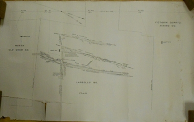
Document - VICTORIA HILL - LETTER TO MR WODETZKI FROM A. RICHARDSON
... should be marked in regard to rock formations, etc. Albert... the area to determine what should be marked in regard to rock ...Handwritten carbon copy of a letter from A Richardson to Mr Wodetzki and a few suggested spots for marking. He also mentions their geologist, Mr Eric Wilkinson may go over the area to determine what should be marked in regard to rock formations, etc. Albert Richardson collection.document, memo, victoria hill, victoria hill, letter to mr wodetzki from a richardson, mines dept, mr eric wilkinson, north old chum mine, ballerstedt's first open cut, lansell's big 180, ballerstedt's second open cut, ballerstedt jun'r, the crushing battery, the victoria quartz, rae's open cut, large cross spur or quartz vein, whip shaft, e j dunn -
 Glenelg Shire Council Cultural Collection
Photograph - Photograph - Seascape, Portland, 1970s
... formation on edge of rock platform. Fishing gear in foreground... shaped rock formation on edge of rock platform. Fishing gear ...Black and white stereoscopic contact print from glass plate negative. Image shows a group of men and women sitting on a rocky platform, against a cliff. Sea in background. Strange shaped rock formation on edge of rock platform. Fishing gear in foreground. Dress late 19th, early 20th century.seascape, portland, photography -
 Federation University Historical Collection
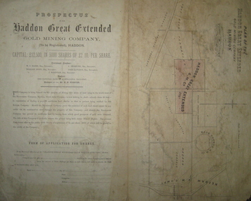
Plan and Prospectus, Plan and Prospectus of the Haddon Great Extended Gold Mining Company
... -Rock Formation.... Propert and Roach's Private Company, and the Trap-Rock Formation ...The Haddon Great Extended GMC was formed sometime in the 1870s for the purpose of mining 270 acres of land lying to the south-west of the Racecourse Company (who at that stage had a shaft at the depth of 86 feet)A printed piece of paper with a prospectus on the left and a plan on the right. The plan includes a shaded area representing the Haddon Great GMC, and shows neighbouring companies such as Racecourse GMC, Haddon Consols, Reform GMC, Haddon Co, and also shows Russel's Private Propert and Roach's Private Company, and the Trap-Rock Formation.haddon great extended gmc, wc elder, william levey, c thorburn, john langdon, hb forster, national bank of australasia, haddon, racecourse company, h.b. forster, w.c. elder, john langdon, william levey, c. thorburn, john langdon, shares, racecourse goldmining company, reform gold mining company, haddon consols, haddon great extended gold mining company, russell -
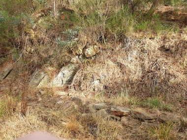
 Halls Gap & Grampians Historical Society
Photograph - B/W, C 1940s -- 50s
... Rock formation is called " The Woolpacks " and was located... 117-119 Grampians Road Halls Gap grampians Rock formation ...Rock formation is called " The Woolpacks " and was located on the Wonderland Track at the top of Silent Street -- however on a Broadbent map of the Grampians no.205 this formation was called the " Wool Sacks " ; and the "Woolpacks" was shown on the map close to Venus Bath.Photo shows distinct slabs of rock balancing on each other. Three people appear in the photo -- a man with a boy and a woman. All three are wearing hats. A large rock outcrop can be seen on right of photos -- trees can be seen on left.The Wool Packs F5030scenery, wonderland range -
 Stawell Historical Society Inc
Photograph, Wonderland Range in the Grampians 1866
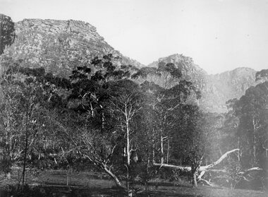
... in 1866. The Grampians, with its wildflowers and rock formations... in 1866. The Grampians, with its wildflowers and rock formations ...Grampians (Wonderland Range). Part of a collection of Photographs by Mr. O.G. Armstrong as commissioned by the Shire of Stawell for the Inter-colonial and Paris Exhibition in Melbourne in 1866. The Grampians, with its wildflowers and rock formations, have attracted people from all parts of the world for many years and have always been promoted strongly by local groups. One such group was the Grampians Tourist Association, formed in 1901. Wonderland would probably be the best known part of the whole area, noted for its rugged and weather worn rock formations and spectacular views, too numerous to mention. The Grampians are now a National Park. stawell -
 Bendigo Historical Society Inc.
Photograph - ANTICLINE FOLD ROCK FORMATION - BENDIGO CREEK
... ANTICLINE FOLD ROCK FORMATION - BENDIGO CREEK...Colour photograph of an anticline fold rock formation... of an anticline fold rock formation - Bendigo Creek possibly in Golden ...Colour photograph of an anticline fold rock formation - Bendigo Creek possibly in Golden Square. An anticline is a structural trap formed by the folding of rock strata into an arch-like shape. The rock layers in an anticlinal trap were originally laid down horizontally and then earth movement caused it to fold into an arch-like shape called an anticline.photograph, landscape, anticline folds -
 Bendigo Historical Society Inc.
Document - MARKS COLLECTION: LANSELL'S 180 MINE PLAN
... ' On LH side 'North Old Chum Co' Plan shows rock formation e.g...' Plan shows rock formation e.g. quartz lava slide. Plan found ...Plan on heavy parchment paper. Printed on bottom of plan 'Lansell's 180 plan' On top RH corner 'Victoria Quartz Mining Co' On LH side 'North Old Chum Co' Plan shows rock formation e.g. quartz lava slide. Plan found in documents from George Lansell auction, donated by Phillipa Marks.bendigo, mining, lansell's 180 mine -
 Ballarat Heritage Services
Photograph - Photograph - Colour, Anticline in the Hepburn Springs Reserve, 2019, 22/04/2019
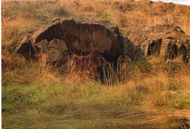
... Anticlines are folded rock formations that have an upwards... Office goldfields Anticlines are folded rock formations that have ...Anticlines are folded rock formations that have an upwards convex shape. Anticlines can exist as a single fold or as a series of adjacent folds of alternating synclines and anticlines. The Hepburn Springs anticline is geologically associated with the west dipping fissures cutting across sandstone strata of the Hepburn Spring anticline.Colour photograph of an anticline at Hepburn Mineral Springs Reserve, in close proximity to the Sulphur Spring. hepburn springs, anticline, geology, hepburn mineral springs reserve, hepburn anticline, hepburn geology -
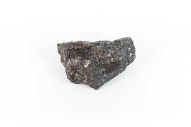 The Beechworth Burke Museum
Geological specimen - Ilvaite
... with of black with shades of beige Ilvaite is a brittle, opaque rock... of beige Ilvaite is a brittle, opaque rock formation that has ...Ilvaite has acquired its name from Ilva (Latin for Elba) Island, Greece, where Ilvaite is most commonly found. The geological setting in which Ilvaite occurs is through contact with magnetite, zinc and copper ore deposits, along with contact metamorphic deposits and zeolite zones. llvaite crystallizes in the form of black prismatic crystals and columns . This specimen was retrieved from Broken hill, known as the world's richest and largest zinc-lead ore deposit. Because of Ilvaite's often unaesthetic crystal formations compared to other minerals, Ilvaite is uncommon in most rock collections, particularly specimens that are not well formed, such as this one. Ilvaite is also a member of the Sorosilicate subclass of the silicate minerals, which have an unusual basic unit of Si2O7, making Ilvaite a unique mineral. Given that Ilvaite is not commonly found in Australia, it marks a unique contribution to an Australian collection of minerals. This specimen is part of a larger collection of geological and mineral specimens collected from around Australia (and some parts of the world) and donated to the Burke Museum between 1868-1880. A large percentage of these specimens were collected in Victoria as part of the Geological Survey of Victoria that begun in 1852 (in response to the Gold Rush) to study and map the geology of Victoria. Collecting geological specimens was an important part of mapping and understanding the scientific makeup of the earth. Many of these specimens were sent to research and collecting organisations across Australia, including the Burke Museum, to educate and encourage further study.A solid hand-sized ferrous iron analogue mineral with of black with shades of beige Ilvaite is a brittle, opaque rock formation that has acquired its name from Ilva (Latin for Elba) Island, Greece, where Ilvaite is most commonly found. The geological setting in which Ilvaite occurs is through contact with magnetite, zinc and copper ore deposits, along with contact metamorphic deposits and zeolite zones. llvaite crystallizes in the form of black prismatic crystals and columns rock, mineral, ilvaite, ilvaite specimen -
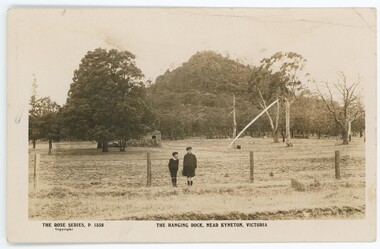 Emerald Museum & Nobelius Heritage Park
Postcard - Postcard of Hanging Rock, Kyneton, Vic
... Rock, a large rock formation sacred to First Nations people... Rock, a large rock formation sacred to First Nations people ...This postcard is part of an album of postcards which date from late 19th century to mid 20th century. It depicts Hanging Rock, a large rock formation sacred to First Nations people for thousands of years prior to European settlement. Hanging Rock became a recreational place for settlers during the 19th century and then became famous through the novel 'Picnic at Hanging Rock' (1967) and the subsequent movie (1975) of the same name. The photograph appears to be c1900s-1920s.This postcard is in an album of postcards dating from the late 19th century to mid 20th century. It reflects the popularity of collecting postcards in Australia which reached a height in the early 1900s until around 1920. Photographic black and white postcard of Hanging Rock c1900s-1920sOn front, printed: 'THE ROSE SERIES, P.1558 THE HANGING ROCK NEAR KYNETON, VICTORIA / Copyright' On back, printed: 'Post Card / The "Rose" Series De Luxe Produced in Australia On extreme left side of back, printed:'[unclear word] By "THE ROSE STENOGRAPHS" / Armadale, Victoria'postcard, photography, 1900s, hanging rock, 1920s, "green postcard album" -
 Marysville & District Historical Society
Book (item) - Hardcover book, Captain W.E. Jones, The Quest for the Perfect Planet-A story of Space Exploration, 1961
... a landscape with trees and plants and rock formations which also... and rock formations which also includes the figures of two people ...A novel by Captain W.E. Jones that was held in the Marysville State School library.A book from the Marysville State School library.Stamp of the STATE SCHOOL No. 1273/ UPPER/ 3/ FICTION/ MARYSVILLE In both front and back inside cover's labels have been removed leaving behind glue residue. Stamp of the Marysville & District Historical Society Inc/ P.O. Box 22/ Marysville 3779captain w.e. jones, planet, earth, space exploration, fiction -
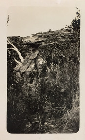 Kew Historical Society Inc
Photograph - Grampians, 1924
... pictures of lookouts, and natural features including rock faces... pictures of lookouts, and natural features including rock faces ...Henry Beater Christian (1886-1962) , was a descendant of one of the earliest settler families in Kew. Employed at the Kew Asylum as a 'public servant', he was a skilled amateur photographer, photographing numerous scenes in Kew and on his travels around Victoria. The majority of his photographs date from 1916 to 1929. His finest photographs are housed in two photograph albums. Digital copy of a photograph from page 14 of the 47-page photograph album containing 261 gelatinous silver images, loaned by Diane Washfold with permission given to digitise and hold a copy in our collection. The first and last pages in the album document the Yarra River at Studley Park and at Kew. The remainder of the album includes photographs of walking and car tours in rural Victoria including 'wilderness' areas in the Grampians, Gippsland and the High Country. Six album pages document a camping trip by Henry Christian to the Grampians in September 1924. The photos include pictures of lookouts, and natural features including rock faces and waterfalls, as well as his camp site. This photo is of rock formations and shrubs."Grampians"henry beater christian (1886-1962), landscape photography, christian-washfold collection, photograph albums, grampians, gariwerd -
 Bendigo Historical Society Inc.
Document - VICTORIA HILL - KEY TO SIGN POSTS ON AREA MAP
... Open - Cut. Special Sign Post, No 2 C Rock Formations..., No 2 C Rock Formations Pitching North, No 2 B Rich shallow ...Three page hand written carbon copy of Sign numbers at Victoria Hill. No 1 North Old Chum Shaft, No 2 Ballerstedt's First Open - Cut. Special Sign Post, No 2 C Rock Formations Pitching North, No 2 B Rich shallow shafts, No 2 A Quartz veins, No 4 A Concrete Dams, No 3 Engine Beds - Lansell's 'Big 180' Mine, No 3 B Lansell's 'Big 180' Shaft, No 4 Twenty Stampers Crushing Battery, No 3 C Foundations - 'Cleopatra Needle' type Chimney for Lansell's 'big 180' Mine, No 5 Victoria Quartz Mine, No 5 A Fou;ndations Victoria Quartz Poppet Legs, No 5 C Foundations Victoria Quartz Winding Plant, No 5 B Victoria Quartz Dams, No 6 Rae's Open - Cut, No 9 Quartz Once Roasted Here, No 12 Anticlinal Arch, No 15 primitive Tunnels, No 14 Beautifully Coloured Rock Formations, No 16 Adit, Graded Bedding, Oblique Fault, Spurry Quartz Veins, No 17 Prospecting Tunnels, No 18 Floyd's Small Crushing Battery, No 19 Gt Central Victoria (Midway) Shaft, No 20 Great Central Victoria (Midway) Engine Bed, No 21 ballerstedt's Small 24 Yard Claim, No 22 Humboldt Shaft, No 23 Wittscheibe's 'Jeweller's Shop', No 24 The 'Adventure' ground, Large Open - Cut, No 26 Luffsman and Sterry's Ground, NO 27 A Round Shaft, Notes prepared by Albert Richardson.mine, gold, victoria hill, victoria hill, victoria hill key to sign posts on area map, north old chum shaft, ballerstedt's first open cut, lansell's big 180 shaft, 'cleopatra needle' type chimney, victoria quartz mine, rae's open cut, prospecting tunnels, floyd's small crushing battery, gt central victoria (midway) shaft, ballerstedt's small 245 yard claim, humboldt shaft, wittscheibe's 'jeweller's shop', adventure, luffsman and sterry's ground, david sterry, sterry's 'gold mines' hotel, round shaft -
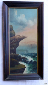 Flagstaff Hill Maritime Museum and Village
Painting - Oil painting, W. Langley-Taylor, Eagle Rock, Warrnambool, Vic, Late 19th to early 20th century
... orientation. Seascape of rock formation and cliffs, two yachts, a two..., portrait orientation. Seascape of rock formation and cliffs, two ...This painting is one of a pair of large paintings by W. Langley-Taylor in our collection. Currently, no further information has been found about the artist but research is ongoing. The subjects of these paintings are seascapes of notable areas of the coast on each side of Port Phillip Bay, south of Melbourne, Victoria. This painting is of Eagle Rock, Warrnambool, which is on the west of Port Phillip Bay. Eagle Rock is located about 400 metres west of Thunder Point, near Shelly Beach. The painting includes the rocky cliff formations looking east towards the Warrnambool Breakwater. The walk from the Thunder Point car park westwards to Shelly Beach has been popular over the decades with residents as well as tourists. Many photographs include the rock, with varying backgrounds depending on the angle of the camera. It is a popular dive site for locals and visitors, in calm weather! The site can be approached by boat from the open sea in favourable conditions, and there is plenty of native marine to be seen in this marine sanctuary. This part of Warrnambool’s rugged coastline is unprotected from the Southern Ocean with its wild icy winds and high seas. The painting’s crashing waves and the northerly direction of the smoke on the steamship sailing north show the effect of the southerly wind. INSCRIPTIONS “Mrs M Irby” and “980/Regency” The significance of the inscription “Mrs M Irby”, on the back of each of the two paintings, has not yet been discovered. Perhaps she was connected with the ship or shipping company “Irby”. A ship named “Irby”, built in Merseyside, Liverpool in 1881 by R & J Evans, Birkenhead. It was a four-masted iron ship built for the White Star Line. Henry Wilson Hewitt bought her in 1882, then later she was owned by Chadwick & Pritchard. In 1888 she was registered under the Irby Ship Co. Ltd. (trading as J. Joyce) in Liverpool. In 1912 Galgate Co. Ltd owned her. She traded between London, England and Australia, and is recorded as being in Melbourne and Hobart. In 1919 the Irby was destroyed by a mine when on her way to England. Or perhaps her name and the inscription in pencil “980/Regency” on the Eagle Rock Warrnambool, painting could be a delivery address for the paintings, perhaps an apartment in a hotel. This painting is significant geographically for its representation of the coastal scenery of Victoria, Australia. It is also significant as one of a pair of paintings of seascape, one at sites each side of Port Phillip Bay. The painting is significant historically as an example of late 19th and early 20th methods and materials used to construct a painting’s frame. Painting oil on board in a dark wooden frame, portrait orientation. Seascape of rock formation and cliffs, two yachts, a two-masted steamboat with red funnel and smoke, flying birds, high waves breaking onto rocks, blue sky with clouds, some tinted pink.. The title is painted on lower left corner and the artist, W. Langley-Taylor, has signed his name on lower right. The inscription on the back is a handwritten script in red crayon or thick red pencil. The board is held in place inside the timber frame with small, dark metal tacks around all sides. Metal eyes join the wire to the frame. Small round, dark metal nail heads are dispersed around the frame and there is a change of colour on both the board and the wood of the frame. Painted on front “W.LANGLEY-TAYLOR.” and “EAGLE ROCK, WARRNAMBOOL, VIC.” Handwritten on back “Mrs. M. Irby” and “980 [underlined] Regency”flagstaff hill, warrnambool, shipwrecked coast, flagstaff hill maritime museum, maritime museum, shipwreck coast, flagstaff hill maritime village, great ocean road, eagle rock warrnambool, w. langley-taylor, oil painting, wall decoration, seascape of victoria's coast, mrs m irby, art, seascape, pair of paintings -
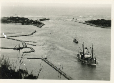 Lakes Entrance Historical Society
Photograph - SS Tambar, c1930
... , rock groynes visible for formation of Bullock Island. Lakes..., rock groynes visible for formation of Bullock Island. Lakes ...Also black and white copy 8 x 13Small format black and white photograph of SS Tambar heading inbound towards Nungurner. Another smaller vessel behind, rock groynes visible for formation of Bullock Island. Lakes Entrance Victoriaships and shipping, jetties, waterways -
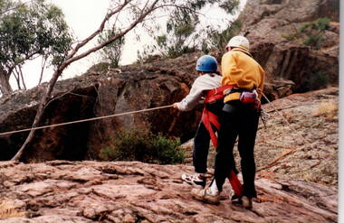 Sunbury Family History and Heritage Society Inc.
Photograph, Bulla Primary School, Hanging Rock, 18th October 1995
... Rock in the Macedon Ranges area in 1995 and one... were introduced to was rock climbing as the formation offers ...The older students were attending a school camp at Hanging Rock in the Macedon Ranges area in 1995 and one of the activities the children were introduced to was rock climbing as the formation offers many sites for this activity.A non-digital coloured photograph of a supervisor instructing a girl who is attempting to do rock climbing. They are doing the activity on a natural rocky plateau.school camps, hanging rock, rock climbing, bulla primary school -
 Bendigo Historical Society Inc.
Document - RAE'S CRUSHING BATTERY - THE RICH VICTORIA HILL & ITS HISTORICAL ASSOCIATIONS
... Open-cut, Quartz Veins (Spurs), rock formations pitching North...), rock formations pitching North, Prospecting shafts 1929 ...The first five pages are photocopies of photos:- 2 of Rae's Crushing Works; Victoria Quartz on Victoria Hill, Ironbark; Looking North from Old Chum Hill to the Victoria Hill; Victoria Hill - from Rae's Open Cut. Introduction covers location of buildings and mines. Mentioned are:- North Old Chum Mine, Ballerstedt's First Open-cut, Quartz Veins (Spurs), rock formations pitching North, Prospecting shafts 1929, Concrete dam, Engine beds of Lansells Big 180 Mine, Lansells Big 180 Shaft, twenty stampers crushing battery, Lansell's Cleopatra Needle type chimney, Victoria Quartz Mine, Victoria Quartz dams, Rae's Open-cut, Quartz once roasted here to an intense heat, Anticlinal Arch New Chum Line, small primitive tunnels, Prospecting tunnels, Floyd's small 5 head crushing battery, Great Central Victoria (Midway) Shaft, Great Central Victoria engine-bed, Ballerstedt's small 24 yard claim, The Humboldt, Adventure ground, The Advance, Luffsman & Sterry's Claim, A round shaft. Small piece of paper with 'Notes on Victoria Hill complete. Notes prepared by Albert Richardson.document, gold, rae's crushing battery, rae's crushing battery, rae's crushing works, victoria quartz mine, from old chum hill, victoria hill from rae's open cut, ironbark, hercules & energetic, midway, wittscheibe, great central victoria, mr & mrs conroy, central nell gwynne, gold mines hotel, john brown knitwear factory, new chum & victoria, rotary club of bendigo south, north old chum, ballerstedt's first open-cut, lansell's big 180 shaft, cleopatra needle type chimney, a roberts & sons, mr e j dunn, h harkness & sons, eureka extd, new chum railway, pearl, inrush of water at victoria quartz, floyd's small 5 head crushing battery, great central victoria (midway), ballertedt's small 24 yard claim, humboldt, humboldt, great central victoria, victoria hill, bendigo & vicinity 1895 p51, j n macartney 1st edition 1871, bendigo goldfield registry 1871, plan of new chum line, mr rae anderson, annals of bendigo obituary 1904, bendigo advertiser, b m l records mines dept, patterson's goldfields of victoria, dickers mining record 23/11/1861, australian mining standard special edition 1/6/1899 p40, bendigo mines ltd, chinese joss house, fortuna, the victoria goldfield 1851 to 1954, the victoria hill 1854 to 1949 -
 Sunbury Family History and Heritage Society Inc.
Photograph, Bulla Primary School, Hanging Rock, 1995
... geological formations. Hanging Rock, also known as Mount Diogenes... and explored the rock for its interesting geological formations ...In 1995, the upper school students from Bulla Primary School attended a camp at Hanging Rock Reserve which is part of the Macedon Ranges. At this camp the students were shown basic rock climbing skills and explored the rock for its interesting geological formations. Hanging Rock, also known as Mount Diogenes, is the traditional land of the Dja Dja Wurrung, Woi Wurrung and Taungurung people. It is a mamelon formed when magma poured from a vent and congealed. There are interesting rock functions at the site such as the Colonnade, the Eagle and the UFO. The highest point on the rock is 718metres above sea level and 105 meters above the land at its base.Hanging Rock is an important geological and volcanic structure in the Macedon Ranges area and in central Victoria. A non-digital coloured photograph of three holiday cabins and a barbecue in a bushland setting. A red car is parked outside one of the cabins as well as two permanent picnic tables.hanging rock, mount diogenes, mamelons, volcanoes, school camps, bulla primary school -
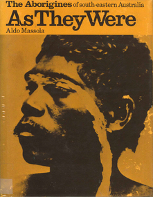 Victorian Aboriginal Corporation for Languages
Book, Aldo Massola, The Aborigines of south-eastern Australia : as they were, 1971
... myths illustrating origins of fire &? natural rock formations... myths illustrating origins of fire &? natural rock formations ...Contents: p.1-3; Origins, arrival in Australia; p.4-9; How they lived - camp sites, dating (including carbon dating); p.10-27; Physical appearance, skin colour, hair, clothing, body ornaments, cicatrization; exchange system, distribution of food, marriage &? sexual relations; the tribe - structure, relationship to land, territory, gives map showing locations of tribes, New South Wales, Victoria &? eastern South Australia, leadership, government, division of labour, status of women, estimated population at white settlement, density of population (Victoria); p.28-31; Language - names &? naming, reproduces Wembawemba vocabulary, notes use of secret languages, gives 12 rules for pronounciation; p.32-53; Religion, spirit beliefs, totemism, moieties, phratries, marriage rules; mythology, gives eaglehawk &? crow myth from Lake Victoria &? other myths illustrating origins of fire &? natural rock formations, mythical beasts (Bunyip, Mindie), stellar beliefs; magic, medicine men, powers, native remedies for sickness, describes ceremony held in Melbourne, 1847 to avert evil, sorcery, pointing bone, love magic, rain makers; messengers, appearance, etiquette, message sticks; p.54-71; Rock art, motifs, colours, decorative art, engraving of utensils, rock engravings, manufacture &? use of pigments, engraving techniques; trade system, objects bartered, meeting places for trade (Victoria), map shows possible routes (south east Australia); corroborees, purpose, body ornaments &? decorations, musical instruments; p.72-93; Ceremonial life, marriage, punishment for infidelity, birth, childhood, games &? amusements, initiation, etiquette of visiting tribes, details of ceremony, womens role, earth figures &? ground designs, bull roarers, female puberty ceremonies; p.94-133; Shelters, fire making, cooking, construction of canoes, wooden implements, use of reeds, animal skins &? sinews, shells; stone tools, cylindro conical stones, scrapers, knives &? microliths; hunting weapons, spear, other methods pits, nets; fishing methods &? spears, traps; food sharing, womens responsibilities for collecting, digging stick, cooking methods, insect foods, plant foods, water resources; manufacture &? use of spears, spear throwers, shields, clubs, boomerangs; inter- &? intratribal fighting; p.134-147; Death, disposal of body - eating of the dead, burial, cremation, platform exposure, dendroglyphs (N.S.W.), Aboriginal burial grounds (Darling &? Murray Rivers), mourning, widowhood, kopi caps (N.S.W.), causes of death, inquest ceremonies, revenge expedition, after death beliefs; p.148-157; The end of the tribes white settlement &? its impact on Aboriginal life, friction between natives &? settlers, establishment of Protectorates; copiously illustrated throughout.maps, b&w illustrations, b&w photographswemba wemba, murray river, darling river, lake victoria -
 The Beechworth Burke Museum
Geological specimen - Brown coal
This particular specimen was recovered from the Lal Lal Coal and Iron Mine in Victoria, 19km from Ballarat. Brown Coal was discovered here in 1857, just alongside the Geelong to Ballarat Railway line. This discovery of lignite (brown coal) was the first in Victoria, which would bring important benefits to the region and state, both of which had previously been reliant on coal imports. In the 1860s, iron ore was found just 5km from Lal Lal, and the area was converted into an Iron Ore Mine. The Lal Lal Iron Mining Company took over operations in 1874, who then peaked iron production in 1884. This mine continued operations until June 1884, when the blast furnace was extinguished and never recommenced. The blast furnace at Lal Lal is considered one of the most important and highly significant sites ion early industrial history in Australia, as it is the only remaining best furnace from the nineteenth century in the Southern Hemisphere. The furnace ruins are 17 metres high, and are clearly visible today on Iron Mine Road, Lal Lal, near the Bungal Dam. This specimen of Lignite (brown coal) is significant, as it was mined from the area where brown coal was first discovered in Victoria, leading to an important and controversial future of the mining and use of brown coal in this State. The Victorian Heritage Database has listed the Lal Lal Coal Mine with local significance, with their Statement of Significance stating: "The Lal Lal coal mine is historically significant as the site of the first discovery of lignite (brown coal) in Victoria, and one that promised important benefits to regional and state industries that were reliant on coal imports at the time. The significance of the stie is reduced by the poor state of preservation of the coal mining and processing fabric". This specimen is part of a larger collection of geological and mineral specimens collected from around Australia (and some parts of the world) and donated to the Burke Museum between 1868-1880. A large percentage of these specimens were collected in Victoria as part of the Geological Survey of Victoria that begun in 1852 (in response to the Gold Rush) to study and map the geology of Victoria. Collecting geological specimens was an important part of mapping and understanding the scientific makeup of the earth. Many of these specimens were sent to research and collecting organisations across Australia, including the Burke Museum, to educate and encourage further study.A hand-sized light-weight, soft and combustable sedimentary rock specimen, that is dark brown in colour. The specimen has jagged edges, as though parts of the rock have crumbled away. Brown coal, or Lignite, is formed naturally from compressed peat, and is typically found in natural basins. The stages to the formation of coal ('coalification') begin with plant material and wood, which will decay if it is not subjected to deep burial or heating, and turn into Peat. Peat, when sufficiently compressed naturally, will turn into Brown Coal (Lignite), and finally into Black Coal (sub-bituminous, bituminous and anthracite). Each successive stage has a higher energy content and lower water content. It is brownish-black in colour. Brown Coal has a high moisture content, between 50 and 75 percent, and a low carbon content. Some Brown Coals may be stratified, with layers of plant matter, which means little coalification has occurred beyond the peat natural processing stage. When Brown Coal is submerged in dilute nitric acid or boiling potassium hydroxide solution, it reacts to produce a reddish solution, of which higher-ranked coals do not. When brown coal is pulverised and burned in boilers, the steam is used to drive turbines, which generates electricity. It is the lowest rank of coal, as when burned, it creates a relatively low heat content, which in turn does not create a great output of steam. burke museum, beechworth, indigo shire, beechworth museum, geological, geological specimen, mineralogy, brown coal, brown coal specimen, lignite, lal lal, lal lal coal mine, lal lal iron mine, ballarat, blast furnace -
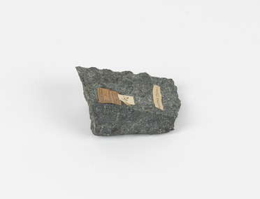 The Beechworth Burke Museum
Geological specimen - Greenstone / Gabbro, Unknown
... , then the rock will melt, resulting in the formation of an igneous rock..., then the rock will melt, resulting in the formation of an igneous rock ...This specimen was recovered from Ceres West of Geelong, Victoria. Greenstone is the name for any metamorphosed basic igneous rock (in the case of this specimen, Gabbro) that gains its greenish colour to the presence of the minerals chlorite, actinolite, or epidote, hence the term 'green' and 'stone'. Greenstone is often formed through metamorphsis along a convergent plate boundary. In the rock cycle (the series of processes that creates the various types of rocks) there are identified three different types of rocks, which are the sedimentary, the igneous and the metamorphic. Metamorphic rocks started out as sedimentary, igneous or earlier metamorphic rocks but changed from their original condition under the effect of high heat, high pressure or hot, mineral-rich fluid. However, if pressure or heat is too high, then the rock will melt, resulting in the formation of an igneous rock. The name used to describe these types of rocks reflects this specific inherent trait of change, since the word “metamorphic” derives from the Greek word “metamorphosis”, meaning “change of form or structure”. Metamorphic rocks form in the Earth`s crust but can be also found on the surface, due to elevation of the Earth`s surface. They are divided into two categories: the foliated metamorphic and the non-foliated metamorphic rocks. Gabbro is a highly useful mineral that is often polished to create cemetery markers and kitchen benches. It is notable for its qualities of durability, being able to withstand extreme elements and wear. Whilst not rare, Gabbro is of great utility and has been highly desirable for its qualities. This specimen is part of a larger collection of geological and mineral specimens collected from around Australia (and some parts of the world) and donated to the Burke Museum between 1868-1880. A large percentage of these specimens were collected in Victoria as part of the Geological Survey of Victoria that begun in 1852 (in response to the Gold Rush) to study and map the geology of Victoria. Collecting geological specimens was an important part of mapping and understanding the scientific makeup of the earth. Many of these specimens were sent to research and collecting organisations across Australia, including the Burke Museum, to educate and encourage further study.Greenstone is a solid hand-sized metamorphic mineral of a green colour. Greenstone is the name for any metamorphosed basic igneous rock (in the case of this specimen, Gabbro) that gains its greenish colour to the presence of the minerals chlorite, actinolite, or epidote, hence the term 'green' and 'stone'. Gabbro is a medium to coarse grained rocks that consist primarily of plagioclase feldspar and pyroxene. Greenstone is often formed through metamorphsis along a convergent plate boundary. Gabbro forms due to cooling and crystallization of magma underneath Earth's surface. Greenstone/Gabbro/from Ceres west/of Geelong. Has old Geological Survey label/and probably collected by/Richard Daintree in 1861/C.Willam 15/4/21/ Other label: 62 /greenstone, metamorphosed, igneous rock, gabbro, chlorite, actinolite, epidote, metamorphsis, rock cycle, various types of rocks, sedimentary, high heat, high pressure, mineral-rich fluid, metamorphosis, foliated metamorphic, non-foliated metamorphic, convergent plate boundary, greenish colour, minerals -
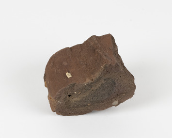 The Beechworth Burke Museum
Geological specimen - Ropy Lava
‘Ropy lava’ is known for its sculptural and layered qualities. It occurs in specific lava flows that are slow moving and slow cooling, allowing for unique formations to be created out of the motion. Ropy Lava is a flow that has a hardened crust with molten material underneath, the tension between these states is what creates its characteristic form. The brown/red hue of the stone is an indication of age, as it is oxidised iron deposits. This rock deposit is thought to be sourced from the area by Talbot, in western Victoria. This area has a rich mineral history and experienced the gold rush in the 1850's. The traditional owners of this area are the Dja Dja Wurrung people.This geological specimen shows the conditions in which the Australian landscape was created as well as provides an indication as to how these events occurred. It is representative of a common natural process that contextualises the formation of Australia with the formation of other landmasses. This specimen is part of a larger collection of geological and mineral specimens collected from around Australia (and some parts of the world) and donated to the Burke Museum between 1868-1880. A large percentage of these specimens were collected in Victoria as part of the Geological Survey of Victoria that begun in 1852 (in response to the Gold Rush) to study and map the geology of Victoria. Collecting geological specimens was an important part of mapping and understanding the scientific makeup of the earth. Many of these specimens were sent to research and collecting organisations across Australia, including the Burke Museum, to educate and encourage further study.Hand sized specimen in brown/red hues42 / victoria, talbot, lava, ropy, ropy lava, mineral, geological specimen, geological, geological heritage, natural stone, natural history -
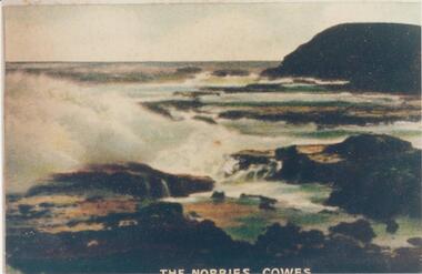 Phillip Island and District Historical Society Inc.
Photograph, Early 20th Century
... rock formation phillip island... donated by Bruce Bennett the nobbies phillip island rock formation ...One of a collection of photographs donated by Bruce BennettColoured copy of a postcard. Rock platform with breakers and Nobbies at top right."The Nobbies - Cowes"the nobbies phillip island, rock formation phillip island, south coast phillip island, coastline phillip island, bruce bennett