Showing 124 items
matching sand dune
-
 Lakes Entrance Historical Society
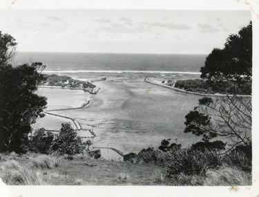
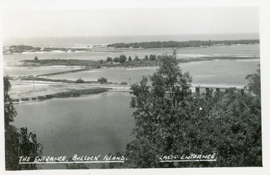
Photograph - The Entrance, 1930c
... to Bass Strait from the Gippsland Lakes. Buildings on sand dunes... from the Gippsland Lakes. Buildings on sand dunes, Bullock ...Black and white photograph showing wooden piers at entrance to Bass Strait from the Gippsland Lakes. Buildings on sand dunes, Bullock Island and rock groynes. Photo taken from Jemmys Point showing shrubbery in foreground. Lakes Entrance Victoriawaterways, topography, boats and boating, islands -
 Port Fairy Historical Society Museum and Archives
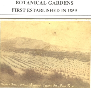
Photograph, 1884
... to stop the erosion of the sand dunes having been stripped of all... Beach about 1884 planted to stop the erosion of the sand dunes ...Marram grass (1st year) South Beach about 1884 planted to stop the erosion of the sand dunes having been stripped of all the tea tree and native grass cover, the tea tree bark being used for tanning leatherBlack and white Photograph of the dunes above Boarding School Bay sewn with Marram grass Marram grass (1st year) South Beach about 1884marram grass, south beach, agriculture, dunes -
 Bendigo Historical Society Inc.
Book - BIT PAPERS, 1971
... , Engineering in Colonial Times, Source-Bordering Sand Dunes along... Sand Dunes along the Loddon River & others, 66 pages with black ...B.I.T. Papers Summer 1970-71, articles by various contributors, contents include, Building the Melbourne-Bendigo Railway, Engineering in Colonial Times, Source-Bordering Sand Dunes along the Loddon River & others, 66 pages with black and white photographs and maps..history, australian -
 Lakes Entrance Historical Society
Photograph - Lake Tyers, Marie Fish, 1978
... June/July 1978 showing that sand dune between lake and ocean... June/July 1978 showing that sand dune between lake and ocean ...Two other colour photographs taken of damage from storms June/July 1978 showing that sand dune between lake and ocean was swept away, road and toilet block undermined numbers 03831.1 and 3831.2 size 9 x 8.5 cmColour photograph showing damage to shore and track to entrance at Lake Tyers Beach Victoriabeaches, waterways -
 Lakes Entrance Historical Society
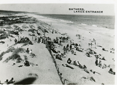
Postcard - Ocean Beach, 1950c
... at the ocean beach. It shows a crowd of people on the sand dunes... at the ocean beach. It shows a crowd of people on the sand dunes ...2 other copiesBlack and white small format postcard of bathers at the ocean beach. It shows a crowd of people on the sand dunes, remains of a brush fence, Southern Ocean and Red Bluff in distance. Taken from original tower, built for Royal Lifesaving Club. Lakes Entrance VictoriaBathers, Lakes Entrance topography, people, beaches, recreation -
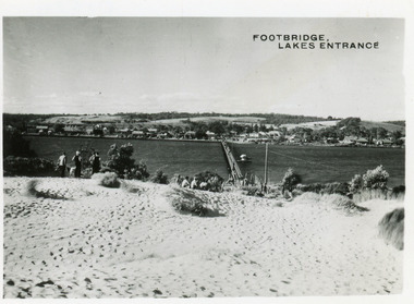 Lakes Entrance Historical Society
Postcard - Township, 1950c
... Cunninghame Arm. It shows people on bare sand dunes in foreground boat... of footbridge over Cunninghame Arm. It shows people on bare sand dunes ...2 copies 6 x 9Black and white small format postcard of footbridge over Cunninghame Arm. It shows people on bare sand dunes in foreground boat moored beside bridge, motor vehicles parked along retaining wall on North shore with town buildings in background. Lakes Entrance VictoriaFootbridge Lakes Entrancebridges, waterways, township, people -
 Lakes Entrance Historical Society
Postcard, Lakes Entrance 1930, 1930 c
... Cunninghame Arm and sand dunes in distance. Track in foreground Myers... shows North Arm with west end of town Cunninghame Arm and sand ...Black and white postcard showing view from top of hill north of Lakes Entrance shows North Arm with west end of town Cunninghame Arm and sand dunes in distance. Track in foreground Myers Street known as Allens Hill in 1930 Lakes Entrance Victoriatownship, waterways, roads and streets -
 Lakes Entrance Historical Society
Photograph, Glenice Soderlund, Lady Harriet barge, Lakes Entrance Victoria, 1/06/1989 12:00:00 AM
... and sand dunes in background Lakes Entrance Victoria. Also... intact. Bullock Island and sand dunes in background Lakes ...Colour photograph showing Lady Harriet barge moored at wharf in Cunninghame Arm mast and rigging intact. Bullock Island and sand dunes in background Lakes Entrance Victoria. Also an enlarged colour lamenated photograph almost identical 04673.1 29 x 19.5 cmbarges, boats and boating -
 Glenelg Shire Council Cultural Collection
Photograph - Photograph - Bridgewater Hotel, Victoria, n.d
... side of door, ground floors, picket fence with gate; sand dunes... fence with gate; sand dunes behind. Photograph Photograph ...Black and white photo of the Bridgewater Hotel, front view. Double storey building, front verandah, tin roof, chimney each side of building. Three windows on first floor, window either side of door, ground floors, picket fence with gate; sand dunes behind.Back: 'BRIDGEWATER HOTEL' -printed in capitals, blue biro -
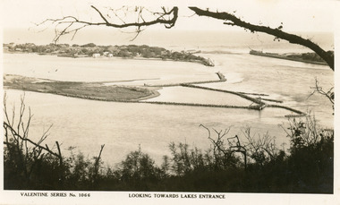
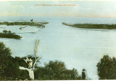 Lakes Entrance Historical Society
Postcard - The Entrance, 1900c
... the sand dunes, taken from Jemmys Point. It shows the works... of the man made entrance through the sand dunes, taken from Jemmys ...Also copy tinted postcard 10 x 15Coloured post card of the man made entrance through the sand dunes, taken from Jemmys Point. It shows the works and settlement at the entrance, Bullock Island and groynes to direct flow of lake waters towards entrance. Two men standing on Jemmys Point. Lakes Entrance VictoriaLakes Entrance, Cunninghame, Victoriaislands, waterways, topography -
 Lakes Entrance Historical Society
Postcard - Bullock Island, The Lakes Studio, 1920c
... Strait and sand dunes. Left foreground shows power pole and water... bridge northern end of piers at entrance to Bass Strait and sand ...One black and white copy 17 x 25Black and white postcard showing North Arm Bridge, Bullock Island and foot bridge northern end of piers at entrance to Bass Strait and sand dunes. Left foreground shows power pole and water bore and telephone poles along Princes Highway Lakes Entrance Victoria.The Entrance, Bullock Island, Lakes Entranceislands, bridges, waterways, topography -
 Lakes Entrance Historical Society
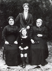
Photograph - Lee Family, 1914 c
... family at the family home The Hummocks on the sand dunes south... of the Lee family at the family home The Hummocks on the sand dunes ...Black and white photograph of women members of the Lee family at the family home The Hummocks on the sand dunes south shore of Cunninghame Arm. Shown are Mrs Kathryn Delahunty, Mrs Cathryn Lee nee Delahunty, Mrs Emily Carstairs nee Lee and Ina Carstairs Lakes Entrance Victoriagenealogy -
 Lakes Entrance Historical Society
Photograph - Lakes Entrance, 1945 c
... overlooking North Arm and township, Cunninghame Arm and sand dunes out..., Cunninghame Arm and sand dunes out to Bass Strait. Hulk of old Baang ...The Hulk of the Baang Yarnda on the North Arm foreshore. (Note in album)Black and white photograph showing view from Kalimna cliff overlooking North Arm and township, Cunninghame Arm and sand dunes out to Bass Strait. Hulk of old Baang Yarnda moored in North Arm, towed there in 1939 and left to rot. Thick vegetation in foreground. Lakes Entrance Victoria.township, waterways -
 National Vietnam Veterans Museum (NVVM)
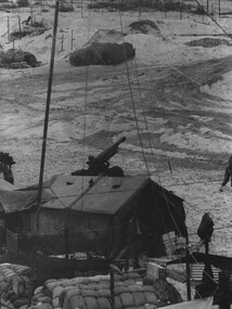
Photograph, Gibbons, Denis, Quiet Time
... detachment area at an Australian Fire Support Base, in the sand dunes... Fire Support Base, in the sand dunes, on the coast, South East ...Denis Gibbons (1937 – 2011) Trained with the Australian Army, before travelling to Vietnam in January 1966, Denis stayed with the 1st Australian Task Force in Nui Dat working as a photographer. For almost five years Gibbons toured with nine Australian infantry battalions, posting compelling war images from within many combat zones before being flown out in late November 1970 after sustaining injuries. The images held within the National Vietnam Veterans Museum make up the Gibbons Collection. A black and white photograph of a quiet time, in a gun detachment area at an Australian Fire Support Base, in the sand dunes, on the coast, South East of the 1st Australian Task Force Base at Nui Dat, Phuoc Tuy Province, South Vietnam. The Battery was supporting Infantry in the area (circa June 1970).photograph, fire support base, 1st atf base, nui dat, phuoc tuy province, infantry, gibbons collection catalogue, photographer, vietnam war, denis gibbons, 105mm howitzer, nui thai vai mountains -
 Lakes Entrance Historical Society
Postcard - Bullock Island
... in entrance to Gippsland Lakes from Bass Strait, sand dunes showing... in entrance to Gippsland Lakes from Bass Strait, sand dunes showing ...Black and white postcard of west end of Bullock Island, showing rock groynes around island, wooden entrance piers in entrance to Gippsland Lakes from Bass Strait, sand dunes showing New Works houses and sheds. A tree branch across top and foreground shrubbery. Lakes Entrance VictoriaLooking towards Lakes Entrance (on front)islands, waterways, room display -
4th/19th Prince of Wales's Light Horse Regiment Unit History Room
Field Sketch, From General Chaytor's HQ After the battle of Bir El Abd, c 1917
... area of sand dunes, with the only named features being...). The country depicted is a vast area of sand dunes, with the only named ...A field sketch by Sgt Otho Hewett looking North toward Bir El Abd (a well near Arish). The country depicted is a vast area of sand dunes, with the only named features being the Canterbury MR Graves, Bir El Abd (a well), graves, Hod el Zawara and Old Turk telegraph line.field sketch, bir el abd -
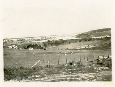 Lakes Entrance Historical Society
Photograph - Butcher's Paddock, Hanlon, Vera, 1940c
... of North Arm, part of town, Cunninghame Arm and sand dunes..., part of town, Cunninghame Arm and sand dunes in background ...Historic home at 90 Captenter St 'Corrumbene' is pictured on right hand side of photograph. Godsell's house opposite on Western side of North ArmBlack and white photograph showing view of lower reaches of North Arm, part of town, Cunninghame Arm and sand dunes in background, and North Arm on right. Photo taken from Allens Hill, Myer St, vacant paddocks in foreground, known as Butcher's Paddock, slaughterhouse and buildings in mid view. Lakes Entrance Victoriatownship, waterways, animals -
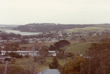
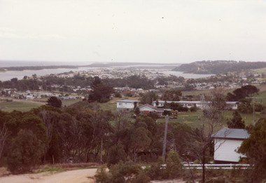 Lakes Entrance Historical Society
Photograph - Township
... , Kalimna Heights, Cunningham Arm and sand dunes on left. Looking... and sand dunes on left. Looking west to Bullock Island and Rigby ...Colour photograph of township of Lakes Entrance showing North Arm, North Arm Bridge, Jemmys Point, Mount Barclay, Kalimna Heights, Cunningham Arm and sand dunes on left. Looking west to Bullock Island and Rigby Island. Photo taken from near Telecom Tower on Merrangbaur Hill. Lakes Entrance Victoria bridges, waterways, islands, township -
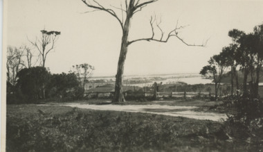
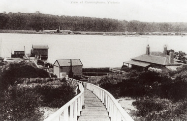 Lakes Entrance Historical Society
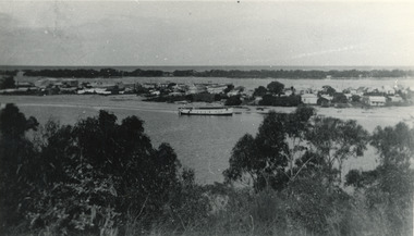
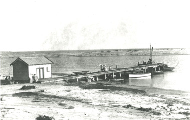
Photograph - New Works, 1910c
... New Works Jetty over the sand dunes with small shed on jetty... boardwalk from New Works Jetty over the sand dunes with small shed ...Also black and white copy 12.5 x 18 cm with smear of purple ink in top left hand corner, purchased from Helen ClothierTinted black and white photograph showing boardwalk from New Works Jetty over the sand dunes with small shed on jetty, small one room Boole Poole school on right of boardwalk and harbour master's house on right. Club Hotel on opposite foreshore and town on far right. Kalimna escarpment in background, at Lakes Entrance, Victoria.View of Cunninghame Victoriaboardwalk, waterways, ships and shipping, township, topography -
 Lakes Entrance Historical Society
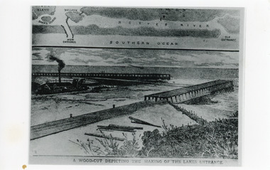
Photograph - Entrance Works, 1880c
... of the lakes, old and new entrances, southern ocean and sand dune... of the lakes, old and new entrances, southern ocean and sand dune ...Photographic reproduction of woodcut drawing of the building of the entrance and map above of location.Black and white photograph of a woodcut showing dredge working between timber constructed piers on entrance from the lakes to the ocean Bass Strait. Piers unfinished, timber lying around, sand in the entrance. Map above showing position of the lakes, old and new entrances, southern ocean and sand dune vegetation. Lakes Entrance VictoriaA woodcut depicting the making of the Lakes Entrance.public works, dredging, waterways -
 Lakes Entrance Historical Society
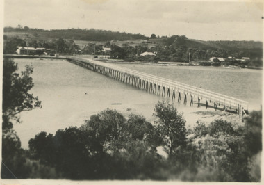
Postcard - North Arm bridge. Lakes Entrance Victoria 1905, Cooper, Alexander, 1908c
... with a small jetty, Club Hotel, sand dunes facing Bass Strait. Post... with a small jetty, Club Hotel, sand dunes facing Bass Strait. Post ...On back of postcard 'Postage one penny without any communication with communication ordinary letters'|This is the before paired photograph used in the 150 year Lakes Entrance 1858-2008 display|The after paired photograph number is 01147.1|Also one 12 x 16 framed photograph used in room display.|Cooper based in Paynesville 1908-1909Sepia giant post card dirt road leading to the first North Arm bridge. Horse facing two bovines on bridge, mud flat with a small jetty, Club Hotel, sand dunes facing Bass Strait. Post and Rail fence on side of road. Shaggy dog in road. Dieback of melaleuca and reeds on mudflats. Lakes Entrance VictoriaCunninghame from the Cutting A.Cooper photo- right hand cornerroads and streets, bridges, fences, animals, room display -
 Lakes Entrance Historical Society
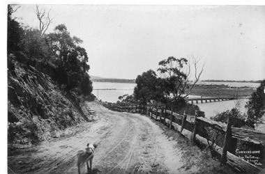
Postcard - Cunninghame Arm footbridge Lakes Entrance Victoria, H D Bulmer, 1940
... taken from the top of the sand dunes looking towards the few... of the sand dunes looking towards the few houses of Lakes Entrance ...Also two black and white postcards looking across footbridge to township 04271.1, 04271.2 size 9.5 x 14 cm 1940 cBlack and white postcard of Cunninghame Arm footbridge taken from the top of the sand dunes looking towards the few houses of Lakes Entrance Victoria Stamp on back The Lakes Studio Lakes Entrance. Also two black and white postcards looking across footbridge to township 04271.1, 04271.2 size 9.5 x 14 cm 1940 cbridges, recreational facilities, surf lifesaving, waterfront -
 Lakes Entrance Historical Society
Photograph - Snowy River.Marlo Victoria, 1910 c
... on jetty, sand dunes across river and ocean beyond dunes Marlo... at left. Trolly on rails on jetty, sand dunes across river ...Black and white photograph showing four small boats at jetty near mouth of Snowy River. Shed at left crane at end of jetty. Three ladies walking on jetty and people in front of shed and three people sitting in shade of shed at left. Trolly on rails on jetty, sand dunes across river and ocean beyond dunes Marlo Victoriarivers, boats and boating, jetties -
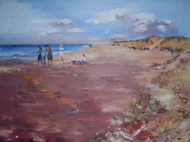 Glenelg Shire Council Cultural Collection
Painting, Julie Kent, Beach Scene, n.d
... Scene depicting a beach. On the right are sand dunes...) Scene depicting a beach. On the right are sand dunes with grass ...Hung in CEO's Office 5/9/2003Scene depicting a beach. On the right are sand dunes with grass covering them. On the left is the ocean. The beach runs from foreground left to the upper centre of image, diminishing in size. In centre left of image three standing adult figures and one child stand to the left of a seated figure wearing a red hat. A fishing pole is braced in the sand beside the figure's chair.Front: J Kent (blue paint, lower right) Back: (unknown) -
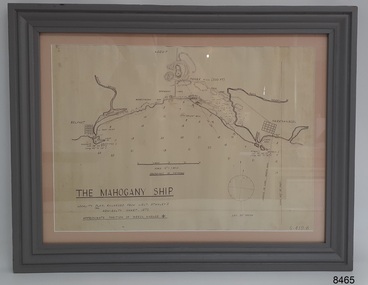 Flagstaff Hill Maritime Museum and Village
Document - Location Chart, The Mahogany Ship, 2007
... intervals and shows the shore and sand dunes, lighthouses and other... intervals and shows the shore and sand dunes, lighthouses and other ...This chart shows a possible site for the fabled wreck called the 'Mahogany Ship'. Flagstaff Hill’s collection includes other objects that some say could be relics from this Ancient Wreck, (also called the Gold Ship, or the Ancient Vessel). The chart shows the coordinates for the Summits of Griffith Island and of Middle Island. It also has the depths of the sea at various intervals and shows the shore and sand dunes, lighthouses and other reference points. The mystery of the Mahogany Ship began in 1836 when two shipwrecked sealers discovered the remains of an “ancient vessel” in the sand dunes about four miles west of Warrnambool. Since the last recorded sightings in the 1880’s the true origin of the Mahogany Ship has remained one of Australia’s most famous historical mysteries or fables. One of the more recent theories is that the vessel was one of the Portuguese ships exploring the Australian coast in 1522. For over one hundred years searchers have attempted to locate and identify the wreck. The search continues for the tangible evidence which will once and for all establish the Mahogany Ship’s place in Australia’s History.The chart represents the worldwide interest in locating the wreck of the Mahogany Ship. Locating the actual wreck or proving the existence of a Portuguese ship's wreck could change the history of the discovery of Australia. A Mahogany Ship committee was formed to gather and research information about the discovery of the wrecked ship. A large amount of money was offered as a prize for finding the wreck or parts of it. People have written books, painted images, made videos and told tales of the ship but it continues to remain a mystery or even a fable. The chart is significant for its possible link to one of Victoria’s and Australia’s maritime mysteries, the Mahogany Ship (also known as the Ancient Wreck). It is one of very few known relics that could give evidence of the existence and history of the vessel. It is listed on the Victorian Heritage Register S438 as it is one of Victoria’s oldest recorded shipwrecks. The identity of the vessel has the potential to change Australia’s history.A chart in a wooden frame, behind glass. The chart shows the approximate position of the mystery Ancient Wreck, later called the "Mahogany Ship". The chart is a copy and is based on the Admiralty Chart by Lieut. Stanley, dated 1872. Lower left: "THE MAHOGANY SHIP" "LOCALITY PLAN, ENLARGED FROM LIEUT. STANLEY'S ADMIRALTY CHART 1872" "APPROXIMATE POSITION OF WRECK MARKED [symbol of a Portuguese cross]" Other labels on chart: "BELFAST" "PORT FIARY" "GRIFFITHS I" "RIVER MOYNE" "RIVER MERRI" "ARMSTRONG BAY" " GORMANS LANE" "TOWER HILL" "KOROIT" "HELEN ROCK" "WARRNAMBOOL" "LADY BAY" "MIDDLE I" "LIGHT HO." Lower right: "G 410 B" Label on the back; "This chart presented to the Mahogany Ship Committee and Flagstaff Hill by Avis Quarrell, April 2007"warrnambool, shipwrecked coast, flagstaff hill maritime museum, shipwreck coast, mahogany ship, ancient vessel, ancient wreck, portuguese ship, coastal reserve, fabled wreck, gold ship, griffiths island, belfast (now port fairy), koroit, location plan, leuit. stanley, admiralty chart 1872, tower hill, merri river, moyne river, middle island, helen rock, armstrong bay, griffiths land -
 Lakes Entrance Historical Society
Photograph - Bullock Island, Fraser Ian, 1920c
... and bridge, entrance to Bass Strait and sand dunes along Cunninghame... Strait and sand dunes along Cunninghame Arm. Western end ...Black and white photograph of Bullock Island, showing Prince's Highway from North Arm bridge, east end of Bullock Island and bridge, entrance to Bass Strait and sand dunes along Cunninghame Arm. Western end of Bullock Island bridge raised to allow small boats access to North Arm and Cunninghame Arm, became known as Humpy Bridge. Lakes Entrance Victoria islands, waterways, topography, bridges -
 Lakes Entrance Historical Society
Photograph - Township, Fish, Marie, 1985c
... on right, Cunninghame Arm and sand dunes on left. Looking towards... Barkly, Kalimna Heights on right, Cunninghame Arm and sand dunes ...\Colour photograph of township showing, North Arm and North Arm Bridge, Jemmys Point, Mount Barkly, Kalimna Heights on right, Cunninghame Arm and sand dunes on left. Looking towards Bullock Island and Rigby Island and Hopetoun Channel in centre background. Sea Vista flats in foreground. Photo take from near Telecom Tower on Merrangbaur Hill circa 1985. Lakes Entrance Victoria bridges, waterways, township -
 Lakes Entrance Historical Society
Photograph - Township, Fish, Marie, 1985c
... on right, Cunninghame Arm and sand dunes on left. Looking towards... Barkly, Kalimna Heights on right, Cunninghame Arm and sand dunes ...Colour photograph of township showing, North Arm and North Arm Bridge, Jemmys Point, Mount Barkly, Kalimna Heights on right, Cunninghame Arm and sand dunes on left. Looking towards Bullock Island and Rigby Island and Hopetoun Channel in centre background. Sea Vista flats in foreground. Photo take from near Telecom Tower on Merrangbaur Hill circa 1985. Lakes Entrance Victoria bridges, waterways, township -
City of Kingston
Photograph - Colour, 6 March 1993
... . The foreshore precinct comprises a wide sandy beach, with low sand dunes.... The foreshore precinct comprises a wide sandy beach, with low sand dunes ...Edithvale is a suburb in the City of Kingston. It is located between Aspendale and Chelsea on the Port Phillip Bay and built within remnant areas of the Carrum Carrum swamp. The foreshore precinct comprises a wide sandy beach, with low sand dunes and numerous historic boat sheds. The suburb consists of older style dwellings and former holiday houses, combined with mid-century housing and newer homes. The large blocks are increasingly subdivided and the existing dwellings demolished to accommodate units and townhouses, thus changing the landscape of the area and reducing the tree canopy.The beachside suburb of Edithvale was previously part of the extensive Carrum Carrum Swamp. The area was once a source of fish and eels for the Mayone-Bulluk clan of the Bunurong people. Over time the area was drained and predominantly devoted to dairy farming and holiday houses. The farms were gradually sold and subdivided with a large number of homes built after World War II and in the 1960s. Edithvale is mainly residential with a shopping strip along Nepean Highway but little significant industry was ever established in the area apart from a plaster works and confectionary factory, both now closed.Laminated aerial colour photograph of Edithvale as viewed from Alexandra Avenue in the north to Ella Grove Chelsea/Edithvale in the south. regents Park Aspendale can be seen in the top left. The area is built-up with residential housing and facilities including Edithvale Primary School, numerous churches and the Edithvale Railway station. Large sections depict the remnant Carrum Carrum swamp. Edithvale Common and the former "Duck Inn" (Melbourne Water/Friends of Edithvale Seaford Wetlands) can be seen. Edithvale Recreational reserve, the valodrome and Edithvale Public Golf Course are prominent. The image shows vacant land in the area now known as Aspendale Gardens and the newer residential section of Chelsea Heights is not developed. A bike path has been established to cover the secondary drain. The Golf Links Court residential development located off Hughes Avenue is a large vacant block.Black type on white adhesive label: 6-3-93 Black type on white adhesive label: 25/9211, 6/3/93, 11.20 am Black type on white adhesive label: 9211 Yellow circular adhesive sticker Black pencil: 9211 6-3-93 arrow pointing Nedthvale, carrum carrum swamp, aspendale, chelsea -
City of Kingston
Photograph - Colour, Circa 1993
... . The foreshore precinct comprises a wide sandy beach, with low sand dunes.... The foreshore precinct comprises a wide sandy beach, with low sand dunes ...Edithvale is a suburb in the City of Kingston. It is located between Aspendale and Chelsea on the Port Phillip Bay and built within remnant areas of the Carrum Carrum swamp. The foreshore precinct comprises a wide sandy beach, with low sand dunes and numerous historic boat sheds. The suburb consists of older style dwellings and former holiday houses, combined with mid-century housing and newer homes. The large blocks are increasingly subdivided and the existing dwellings demolished to accommodate units and townhouses, thus changing the landscape of the area and reducing the tree canopy.The beachside suburb of Edithvale was previously part of the extensive Carrum Carrum Swamp. The area was once a source of fish and eels for the Mayone-Bulluk clan of the Bunurong people. Over time the area was drained and predominantly devoted to dairy farming and holiday houses. The farms were gradually sold and subdivided with a large number of homes built after World War II and in the 1960s. Edithvale is mainly residential with a shopping strip along Nepean Highway but little significant industry was ever established in the area apart from a plaster works and confectionary factory, both now closed.Aerial colour photograph of Edithvale as viewed from Alexandra Avenue in the north to Ella Grove Chelsea/Edithvale in the south. The area is built-up with residential housing and facilities including Edithvale Primary School, numerous churches and the Edithvale Railway station. Large sections depict the remnant Carrum Carrum swamp. Edithvale Common and the former "Duck Inn" (Melbourne Water/Friends of Edithvale Seaford Wetlands) can be seen. Edithvale Recreational reserve, the velodrome and Edithvale Public Golf Course are prominent. The image shows vacant land in the area now known as Aspendale Gardens and the newer residential section of Chelsea Heights is not developed. A bike path has been established to cover the secondary drain. The Golf Links Court residential development located off Hughes Avenue is a large vacant block.Yellow circular adhesive sticker on plastic Black ink (marker): * (asterisk) Black type on white adhesive sticker: P000108edithvale, aspendale, chelsea, carrum carrum swamp