Showing 10840 items matching "site"
-
 Ballarat Heritage Services
Photograph - Colour, Sign Explaining toilets, Old Sarum, England, English Heritage Site, 01/11/2016
William the Conqueror inherited Old Sarum from the last Saxon king of England. It was an ideal site for a royal castle. It was here in 1070 that William paid off his army after a long and bitter campaign in northern England. It was here in 1086 that he called together all the major landholders in England so they could swear allegiance to him. It was a crucial moment. The Domesday Book was being written, a threatened Viking invasion had only just been averted and William's eldest son was in armed rebellion. Old Sarum was an important place where this Norman king of England held power. In 1794 the Ordnance Survey set out to check the accuracy of the first mapping of Southern England, which had begun ten years earlier. From a point just below Old Sarum Lieutenant William Mudge laid out a base-line 36,574 feet (11,253 metres) long. From each end of the line the positions of distant places were plotted using a huge theodolite made in 1791 by Jesse Ramsden. The accuracy of the process, which was repeated all over England, depended on Jesse Ramsden's craftsmanship and on William Mudge's surveying skill in setting out this first base-line from Old Sarum. The nearer end of Mudge's line is marked by an inscribed stone beside the modern A345 at Old Sarum. Colour photograph of a sign explaining toilets at Old Sarum, English Heritage Siteordnance survey, william mudge, jesse ramsden, william the conqueror, old sarum, saxon, 1086,, england -
 Whitehorse Historical Society Inc.
Map, Site for Wesleyan Church, Nunawading, 1855
Photocopy of manuscript map showing names of landholders.Photocopy of manuscript map showing names of landholders. Note on verso: Plan of allotments in the City of Melbourne appropriated to the Wesleyans. Site for Wesleyan Church, Nunawading 1848 (Corner of Burwood and Elgar Roads - S of Burwood, W of Elgar)Photocopy of manuscript map showing names of landholders. churches, wesleyan church, burwood, burwood road, burwood, elgar road, burwood, maps -
 Federation University Historical Collection
Plan, Ballarat School of Mines Schematic Proposal for the Former Ballarat Brewery Site
The Project Manager for the Ballarat School of Mines Brewery Building was Peter Davies. The plan suggests the closure of Lydiard Street South Copy of the Site plan for the Ballarat School of Mines Brewery Building, built on the site of the former Ballarat Brewery. The plan shows where the new building sites in relation to all other buildings at the Ballarat School of Mines ballarat school of mines, brewery building, ballarat brewery, architectural plans, schematic proposal, smb campus, former ballarat gaol, chimney tower, m.b. john building, lydiard street south, armstrong street south -
 Ringwood and District Historical Society
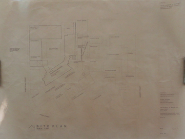
Letter, Cheevers, Margaret (Mayor), Letter from Margaret Cheevers to Desmond Lindsay referring to his work on the history of the site of the City of Ringwood Bowls Club - 2/08/1994, 2-Aug-94
Letter from Margaret Cheevers to Desmond Lindsay referring to his work on the history of the site of the City of Ringwood Bowls Club.Letter from Margaret Cheevers to Desmond Lindsay referring to his work on the history of the site of the City of Ringwood Bowls Club. One page,white paper, printed on Ringwood Council letter head. +Additional Keywords: Cheevers, Margaret (Mayor) / Lindsay, Desmond44 Lyons Rd. North Croydon 3134 27th. June, 1994 City of Ringwood Civic Centre The Mayor Mrs. B. Cheevers Dear Madam, I am pleased to say to you and the Councillors of the City of Ringwood that our family residence on both sides of my family exceeds in excess of one hundred years and it was during a family get together that an interesting anecdote was revealed relating to the land occupied by the Ringwood Bowling Club soon to occupy new premises in Warrandyte Road. The land that became the home of the Bowling Green was given by Thomas Grant, the previous owner was Captain Miles, father of the long standing Councillor the late Temple Miles. The incident I refer to was during World War 1 when Captain Miles an English Loyalist publicly stated he would give a block of land to the widow of the first Ringwood man killed in action. That man was James Brain (refer to Clock Tower Memorial) who married my father’s wife’s sister. Captain Miles made good his offer and the land was the land still occupied by the Ringwood Bowling Club. The land at that time had a small creek running through the centre and the young War Widow suffering grief was advised by another snide councillor (no name) not to accept it, saying it would not be worth it. Ringwoods’ first casualty during World War 1 left a widow and two young sons, all who have passed to their eternal reward. I still do not know if the Council has an historian, but thought it worth telling even if only the Bowling Club were to learn and proud to say my brother Jack had become club Champion on Sacred Soil. Sincerely yours Desmond J Lindsay -
 Falls Creek Historical Society
Document - Site 4 - Design Of Extension Of Christie Street Completed
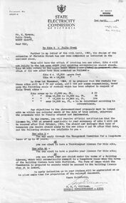
Bob (Herman) Hymans (a former member of the Royal Netherlands Navy) was born in Bloemendaal, Holland on 30th September 1922. During World War II he fought against the Japanese in the Dutch East Indies (now Indonesia) and was imprisoned in Changi and on the Burma Railway. After gaining qualifications as a Ski Instructor, Bob arrived in Falls Creek in July 1950. Working as an Instructor and Supervisor at Bogong Lodge, Bob decided his future was in accommodation. He was successful in negotiating an indenture for land from the State Electricity Commission (SEC). It took Bob two years to build his Grand Coeur Chalet but, tragically, it was burned down in August 1961. Bob also built the first Chairlift in Australia. This was a single chairlift and the structure was built from wooden electricity poles. He was constantly full of new ideas and proposals for the village. Bob Hymans died on 7th July 2007. This Collection of documents and letters tells the story of Bob's endeavours to develop Falls Creek into the ski village it is today.This letter is significant because it reflects the relationship between Bob Hymans, the State Electricity Commission and the Management Committee.A letter to Mr. Hymans' from the SEC outlining changes to be made to the land divisions in Christie Street. The intention was to create two separate sites - Site 4 and Site 4A. SIte 4 was the location of Mr Hymans' existing accommodation. He had submitted a proposal for development of Site 4A. The dimensions of each site and the proposed rentals is included in this letter. His current lease would expire on the 31st October 1964, so Mr Hymans needed to indicate what future lease arrangement he desired to pursue.falls creek tourist area management committee, bob hymans, falls creek administration -
 RMIT Design Archives
Diazotypes, Robin Boyd's Sketch for combined project 60-64 Clarendon St + corner site, 1968
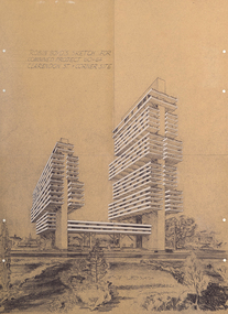
Robin Boyd’s unbuilt scheme for two residential towers for Carnich Pty Ltd in East Melbourne is one of his most striking late projects – remarkable for its daring scale, its indebtedness to the megastructural polemics of Paul Rudolph and Japanese Metabolism, and its prescience – a high-rise apartment building now sits on the same site. The drawing is spectacular: trays of space are held aloft on angled concrete props that branch off trunk-like vertical slabs. With balconies and spandrels highlighted in white, the scheme’s dynamism echoes El Lissitzky’s mad Wolkenbugel (‘Skyhooks’) while also signalling a tragic last hurrah before Boyd’s 1971 death. Philip GoadIncludes sketch of two structures and surrounding flora.Inscribed upper left of recto, "ROBIN BOYD'S SKETCH FOR / COMBINED PROJECT 60-64 / CLARENDON ST. + CORNER SITE"architecture, mid-century modern, emigre, rmit design archives -
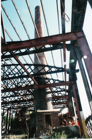 Whitehorse Historical Society Inc.
Photograph, Wunderlich Site
Coloured photo of Chimney at Wunderlich Site.victorian heritage register, wunderlich limited -
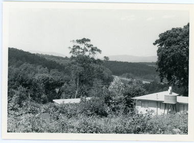 Mt Dandenong & District Historical Society Inc.
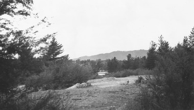
Photograph, View From Ernest Road To Site Of "Kia-Ora"
John Lundy-Clarke grew up in the Kalorama/Mt Dandenong area and later in life (1972-74) began to write a comprehensive history of the area working from an original settlement map in an effort to cover all areas. The photograph taken c1973 from Ernest Road looks over the site of the Kia-Ora guesthouse which is marked by the oalm tree that can be seen at the front of the flat roof close to the gum tree trunk. Situated on Barber’s Road, ‘Kia-Ora’ was built in 1912 by George Barber. It was later leased by a Mrs Pemberthy. “Kia-Ora’ was one of four places connected when the telephone was brought into the district in 1912. The other places were ‘Mountjoy’, ‘Cherry Farm’ and ‘Callum House’. ‘Kia-Ora’ was burnt down in 1924.Black and white photograph showing a house with water tank in right foreground and another flat roof centre foreground. There is a handwritten description by John Lundy-Clarke on the reverse.View 1973 from corner of Ernest Rd and Outlook Drive Lot 24 Village Settlement looking over the site of “Kia Ora” to the pioneers clearings. The palm tree seen above the flat roof (Rex) on left, is on the exact site of “Kia Ora”. Photo JLCernest road, john lundy-clarke, kia=ors, guest house, guesthouse -
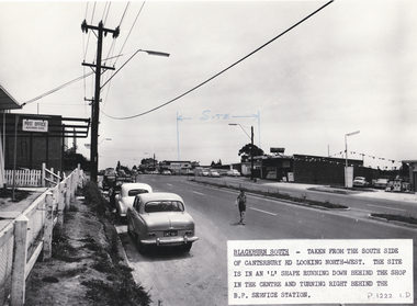 Whitehorse Historical Society Inc.
Photograph, Site of Blackburn Fibrous Plaster Works, 9/11/1962 12:00:00 AM
The Blackburn South Post Office was in 1962 housed in a building originally built as a P.O. for the 1956 Olympics games. It was located in the grounds of the M.C.C. and was transported to the Blackburn South site. Demolished c1970s. Information supplied by Stan Hander, 34Drummond Street, Blackburn South. He worked near the P.O. during the Olympics.Black and white photo of site of Blackburn Fibrous Plaster Works, Canterbury Road, Blackburn South. On left hand side can be seen the Blackburn South Post Office ( see History below).blackburn fibrous plaster works, blackburn south post office., hander, stan, olympic games -
 Ringwood and District Historical Society
Photograph, Site of clock tower after removal., Ringwood. 1967 (2 views)
Written on back of photo SS0195., "Site of clock tower looking up Warrandyte Rd., 1967". On SS0197: "Site of clock tower, June 1967" -
 Ringwood and District Historical Society
Photograph, Site of Antimony Mine 1964
Written on backing sheet, "Site of Antimony Mine 1964. Mullock was used in making a lot of the roads in Ringwood. Site now occupied by Civic Centre." -
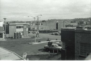
 Ringwood and District Historical Society
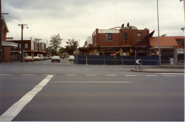
Photograph, Maroondah Highway Central, Ringwood. Old Town Hall site cleared- 1971
Black and white photograph (2 copies- 1 large, 1 small)Written on back of smaller photograph: "Old Town Hall site cleared". Image shows eastern wall of Midway Arcade exposed by clearing of site. -
Whitehorse Historical Society Inc.
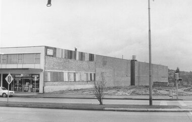
Article, Long-vacant Site to get apartments, 2016
After 20 years as a vacant site, the Blackburn former Caltex Service Station site in Blackburn Road is offered for sale for 20 apartments.After 20 years as a vacant site, the Blackburn former Caltex Service Station site in Blackburn Road is offered for sale for 20 apartments. After 20 years as a vacant site, the Blackburn former Caltex Service Station site in Blackburn Road is offered for sale for 20 apartments. blackburn road, blackburn, caltex service station -
Federation University Historical Collection
Photograph, Former Ballarat Brewing Company Construction Site
Construction on the site of the former Ballarat Brewing Company.ballarat brewing company, brewery building, bulldings -
 Ballarat Heritage Services
Photograph - Colour, Avebury World Heritage Site, Prehistoric Monuments, England, 2017
Colour photograph of the Avenury World Heritage Site.prehistoric monuments, avebury world heritage site, rocks -
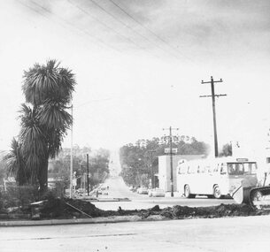
 Melbourne Tram Museum
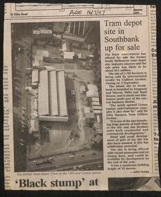
Newspaper, The Age, "Tram depot site in Southbank up for sale", 16/07/1997 12:00:00 AM
Newspaper clipping, The Age 16/7/1997, titled "Tram depot site in Southbank up for sale", advising the depot site would be sold by Colliers Jardine. Gives details of the site and has an aerial photo. Quotes John Marasco of Colliers. Written by John Hurley.trams, tramways, sale of land, south melbourne depot, southbank depot, tram depot -
Federation University Historical Collection
Report, Jack Harvey, The Site of the Eureka Stockade, 1993, 1993
Jack Harvey presented these notes at a public presentation at the Ballarat University College, 19 October 1993.Twelve page document relating to the site of the Eureka Stockade.eureka stockade, eureka, eureka site, harvey, jack harvey -
 Whitehorse Historical Society Inc.
Photograph, Demolition Site, 1/11/1983 12:00:00 AM
Coloured photo of demolition site on corner of Station Street and astation street mitcham, whitehorse road mitcham, demolition site -
 Buninyong & District Historical Society
Photograph - Original Photograph, Geoff Little, Peter Whykes at site of original Slaughterhouse, Durham Lead, 1995
IndustryPeter Whykes at site of original Slaughterhouse, Durham Lead.buninyong, whykes, slaughterhouse, durham lead, butchers, peter whykes -
Port Melbourne Historical & Preservation Society
Plan - Market site and Council Depot, City of Port Melbourne, City Engineer, City of Port Melbourne Site plan of Market Properties and Council Depot, 1938 - 1939
City of Port Melbourne Site plan of Market Properties and Council Depot. Site plan also shows the library and old Fire Station. Made approximately 1938 to 1939. Pencil markings show later use of the site when the market property was used as part of the council depot.red pen "686"built environment - civic, built environment - commercial, engineering department - city of port melbourne -
University of Melbourne, Burnley Campus Archives
Plan, Circus Site, c. 1990
(1) Copy of Plan: City of Richmond City Engineers Department Circus Site: includes Descriptions of Site Preparation, Plant List and Plant Order List. (2) On tracing paper: Plant Plan. (3) On tracing paper: "Yarra Vegetation Survey - Site 3," Plant Plan(1) Handwritten on reverse, "Richmond Council - Yarra Blvd to Bridge Road."circus, survey, richmond, vegetation survey, colin mock, yarra river -
Whitehorse Historical Society Inc.
Newspaper, Fight Drags On Over Ex-School Site Plans, 28/07/1992 12:00:00 AM
Local Residents make submissions to the Community Services & Planning Committee of Nunawading CouncilLocal Residents make submissions to the Community Services & Planning Committee of Nunawading Council over siting of 22% Open Public Space on former Middlefield Primary School site.Local Residents make submissions to the Community Services & Planning Committee of Nunawading Council middlefield primary school, city of nunawading, primary schools -
 University of Melbourne, Burnley Campus Archives
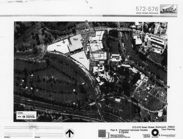
Photograph - Black and white print, Billard Leece R. Corporation, Proposed changes to Burnley Campus site, 2003
Laminated photograph of Burnley site and surroundings. Buildings 1-9 (on area sold off) outlined. Vehicular Site Access Routes marked. By Billard Leece Partnership. R. Corporation No TP 007 REV C August 2003. Typed paper attachment describes proposed development of site.areas sold off, burnley campus, adjustments to site -
 Whitehorse Historical Society Inc.
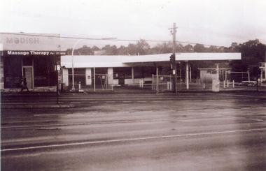
Photograph, Site of new Nunawading ALDI Store, 1/06/2009
Black & white photograph of the site of the proposed new Nunawading ALDI store. The site was the former Caltex Service Station in Springvale Road, Nunawading on the east side and south of the railway line.springvale road nunawading, aldi, caltex service station -
 Ringwood and District Historical Society
Photograph, Ringwood cool store demolition site, 1962
Black and white photograph (1 large, 2 small copies)Typed below large photograph: "Overlooking the cool store site, 1962". Written on back of small photograph: "Cool store site cleared. Taken from top of Town Hall." -
 Ringwood and District Historical Society
Photograph, Town hall site after demolition, from railway bridge. Ringwood. ca 1971-73
Undated, but after town hall demolition (1970) and others in this SS358 series are 1971-73Written on back of photograph, "Town hall site from railway bridge." -
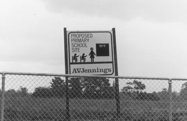 Ringwood and District Historical Society
Photograph, Proposed primary school site. Ringwood, 1982
Catalogue card reads, "Ringwood, 1982. Proposed primary school site". -
 Ringwood and District Historical Society
Photograph, Site of William's Orchard, Mullum Rd. 1964
Written on backing sheet, "Site of William's Orchard, Mullum Rd. 1964". -
Federation University Historical Collection
Video Presentation, Alan Keeley, The Eureka Stockade Site by Jack Harvey, 1993, 19/10/1993
MP4 File of a presentation by Jack Harvey on the Site of the Eureka Stockade. ballarat, eureka stockade, eureka stockade site, jack harvey, alan keeley -
University of Melbourne, Burnley Campus Archives
Plan - Photocopy, Burnley Site, c.1970s
Part B. Photocopy of plan of site with proposed changes marked on it.buildings, burnley gardens