Showing 97 items
matching slab building
-
 The Ed Muirhead Physics Museum
Optical glass specimen
Glass rectangular slab consisting of 11 glass plates “welded together”. Slab is concave and squashed on top. Base shows two black lines. An early attempt to manufacture bulk optical glass. -
The Ed Muirhead Physics Museum
Optical glass specimen
Glass rectangular slab consisting of 15 plates “welded/squashed together”. Slab is concave at top. See no 70 for details. -
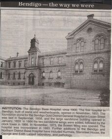 Bendigo Historical Society Inc.
Newspaper - JENNY FOLEY COLLECTION: INSTITUTION
Bendigo Advertiser "The way we were" from 1999. Institution: The Bendigo Base Hospital, circa 1900. The first hospital in Bendigo, built of slabs and weatherboards, opened in November, 1853. The foundation stone for the Bendigo Gold District General Hospital in Lucan Street was laid in September, 1858, and the large sandstone building opened in January, 1859. In 1864, the two sandstone wings were added followed by the clock tower in 1866. In November, 1873, the Bowen Wing was opened. The hospital was incorporated in 1883. Further additions to the Bendigo and Northern District Base Hospital have included Kurmala, Stanisteet House, the George and Edith Lansell laboratory, and pathology.newspaper, bendigo advertiser, the way we were -
 Bendigo Historical Society Inc.
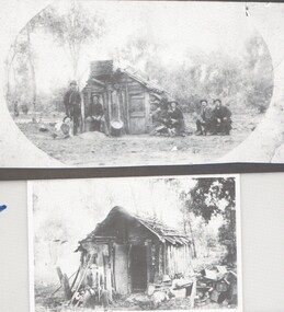
Photograph - HARRY BIGGS COLLECTION: SLAB HUTS IN THE WHIPSTICK
... BUILDINGS House slab hut Slab Huts Whipstick Louis the Dane Paddy ...Two photographs (proofs 81 and 82). 81, The slab hut of Louis the Dane in the Whipstick, date unknown. There are six men in front of the hut, four of them are seated one standing and one reclining on the ground. There are two gold pans visible. 82, Paddy Crow's slab hut in the Whipstick, a man is seated on a stump at the front of the hut, he has a shovel in his hand. There is a large pile of other items (junk) to the right of the hut.buildings, house, slab hut, slab huts, whipstick, louis the dane, paddy crow -
Stawell Historical Society Inc
Map - Drawings, Wendy Jacobs, Western Highway Community Precinct Development Structural Drawings, 2014
501 Slab and Footing Plan. 502 Slab and Footing Details. 505 Roof Framing Plan 506 Steel Framing Elevations - Sheet 1. 507 Steel Framing Elevations and Sections - Sheet 2 508 Steel Framing Details - Sheet 1 509 Steel Framing Details - Sheet 2 SN1 General Notes, Site map & Drawing Index Used in building Historical Society Building Eight (8) A1 Printed plans Structural DrwaingsWendy Jacobs Architect & Heritage consultant may 2014 -
 Ballarat Heritage Services
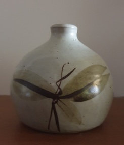
Ceramic, Small bottle by Ray Molony
Ray MOLONY Born Albury, New South Wales "Notes for Raymond Walter Molony: Raymond Walter Molony grew up in the Dandenongs, and Maffra where he went to school. He attenended Sale Technical School, before studying at R.M.I.T. from where he gained a diploma of pottery and technical teaching qualifications. He taught at Shepparton Technical College leaving there in 1977 to become a full time potter. Ray Molony established the Mud Factory Pottery in Shepparton in 1977 after purchasing, renovating and extending the old Kialla Methodist church, and building a two storey mud brick pottery. Two of Ray and Deirdre Molony's sons, Kevin and Russell, were employed during the 1980s and 1990s. Kevin Molony left due in the early 1990s due to the recession at that time, and Russell Molony followed soon after. Both competent throwers, with Russell making some creative slab work while Ray continuing to decorate the works. Ray Molony continued to produce studio ceramics at the kialla studion until selling the property in 2000, and semi retiring to Miepoll. In 2005 he moved to Pottsville New South Wales." studio potterySmall ceramic bottle with leaf designs in brown glaze made at the Mud Factory Pottery by Ray Molony.ceramics, studio pottery, ray molony, mud factory pottery -
 Ballarat Heritage Services
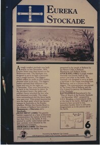
Digital photograph, Brenda & Jack Ford, Diorama Hut Exterior Signage, 14 December 1993
Please find 5 photographs taken by me & my wife Brenda, at Ballarat, on 14 December 1993. Unfortunately, I did not take photographs of the building that housed the exhibit, probably because I thought just how sad and pathetic the entire memorial display looked. It comprised a reconstructed slab hut and nearby a partly-rebuilt fence that represented the hastily-built Eureka Stockade. The signage that detailed the events surrounding the Eureka Stockade was affixed to the hut wall beside the entrance to the interior diorama. In the first photograph, you can see the dark, bare timber colour of the slab wood that held the signage plus (on the left side) one of the numerous holes in the slab walls. This made the display very cold and draughty in its interior. Once inside, you were confronted with an earthen, gravel and leafy floor, which became muddy, after rain, as it was on the day of our visit. The diorama was held in a glass and cement display case. with no lights on. It was dark inside the hut so the diorama was not easy to see unless you inserted a coin into a metal pay-box. Then lights would turn on and a recording of shouting and gunfire (representing the battle noise) would play. I remember the whole experience to be short and underwhelming. To get an idea of the scale of the diorama, you can see Brenda’s elbow & part torso to the left of the photograph labeled “diorama- hut exit”. Once outside the diorama’s slab hut, you could walk across to a partial representation of the stockade’s fortifications, complete with two wagon wheels. This space was also graveled to distinguish it from the rest of the green-lawn park. Finally, you walked up the hill, from the hut and outside display, to visit the old Eureka Stockade monument & cannons. This is still in existence today. Digital photographeureka stockade, sign, diorama, jack ford, brenda ford, memorial -
 Ballarat Heritage Services
Photograph - Digital photograph, Eureka Stockade Replica, 14/12/1993
Please find 5 photographs taken by me & my wife Brenda, at Ballarat, on 14 December 1993. Unfortunately, I did not take photographs of the building that housed the exhibit, probably because I thought just how sad and pathetic the entire memorial display looked. It comprised a reconstructed slab hut and nearby a partly-rebuilt fence that represented the hastily-built Eureka Stockade. The signage that detailed the events surrounding the Eureka Stockade was affixed to the hut wall beside the entrance to the interior diorama. In the first photograph, you can see the dark, bare timber colour of the slab wood that held the signage plus (on the left side) one of the numerous holes in the slab walls. This made the display very cold and draughty in its interior. Once inside, you were confronted with an earthen, gravel and leafy floor, which became muddy, after rain, as it was on the day of our visit. The diorama was held in a glass and cement display case. with no lights on. It was dark inside the hut so the diorama was not easy to see unless you inserted a coin into a metal pay-box. Then lights would turn on and a recording of shouting and gunfire (representing the battle noise) would play. I remember the whole experience to be short and underwhelming. To get an idea of the scale of the diorama, you can see Brenda’s elbow & part torso to the left of the photograph labeled “diorama- hut exit”. Once outside the diorama’s slab hut, you could walk across to a partial representation of the stockade’s fortifications, complete with two wagon wheels. This space was also graveled to distinguish it from the rest of the green-lawn park. Finally, you walked up the hill, from the hut and outside display, to visit the old Eureka Stockade monument & cannons. This is still in existence today. digital photographeureka, diorama, 1993, jack ford, brenda ford, eureka monument, memorial, eureka stockade, eureka diorama -
 RMIT Design Archives
Diazotypes, Robin Boyd's Sketch for combined project 60-64 Clarendon St + corner site, 1968
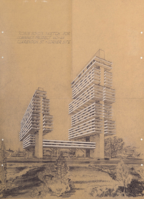
Robin Boyd’s unbuilt scheme for two residential towers for Carnich Pty Ltd in East Melbourne is one of his most striking late projects – remarkable for its daring scale, its indebtedness to the megastructural polemics of Paul Rudolph and Japanese Metabolism, and its prescience – a high-rise apartment building now sits on the same site. The drawing is spectacular: trays of space are held aloft on angled concrete props that branch off trunk-like vertical slabs. With balconies and spandrels highlighted in white, the scheme’s dynamism echoes El Lissitzky’s mad Wolkenbugel (‘Skyhooks’) while also signalling a tragic last hurrah before Boyd’s 1971 death. Philip GoadIncludes sketch of two structures and surrounding flora.Inscribed upper left of recto, "ROBIN BOYD'S SKETCH FOR / COMBINED PROJECT 60-64 / CLARENDON ST. + CORNER SITE"architecture, mid-century modern, emigre, rmit design archives -
 Old Colonists' Association of Ballarat Inc.
Photograph - Newsclipping, The Old Colonists' Association of Ballarat, 1888, 1888
The Old Colonists' Association Ballarat Inc. is a not for profit charitable organisation providing accommodation for elderly people. It manages a 27 Home retirement village at Charles Anderson Grove Ballarat. Accommodation is offered at significantly below market rates. It has been providing low cost accommodation to the elderly since the 1920s. The Association Council overseas the running of this facility on a voluntary basis. OLD COLONISTS' ASSOCIATION OF BALLARAT. (FROM OUR CORRESPONDENT.) BALLARAT, WEDNESDAY. This association, which was founded in August, 1883, and at first known as the Old Identities' Association, now has a roll of 450 members. The objects of the association are "to aid and assist indigent or suffering old colonists ; to raise a fund, by the voluntary subscriptions of the members and the aid of outside donations, for the purpose of relieving members in sickness and old age; for assisting those in extreme distress, to provide the shelter of a home for old and indigent pioneers of the gold fields, their widows, or anyone connected with the association, and in the event of the death of any member to have his remains decently buried, the association defraying the expenses of the funeral (providing that no funds or property are left by the deceased), and to attend the funeral if so desired by the relatives." The qualifications for member ship are good character and repute, and residence in the colonies for a quarter of a century. For some time the association had no property except the regular subscriptions, but about a year ago they obtained from the Minister of Lands the grant of a very valuable block of land in Lydiard-street, the Crown grant of which they received last week. This block has a frontage of 66ft to Lydiard street, worth at least £100 a foot. The ground was given to the association as a site for them to build a hall upon, and with so valuable an asset they had no difficulty in borrowing at 7 per cent, enough money to construct a hall. For revenue purposes the ground floor of the building has been made into four shops, and the rental from these, judging from the rentals of shops in the vicinity, will not only pay all the interest on the borrowed money, but over £200 a year towards clearing off the principal. The officers of the association are Messrs J. P. Murray, President; J. W. Graham and T. Stoddart, vice presidents; D. Fern, treasurer; and J. Fraser, secretary. The Old Colonists' Hall is an elegant looking building in Lydiard-street, lying between the newly-opened mining exchange and the Commercial Club house, and a few doors north of the Post Office. The style of the facade is classic. The lower portion of the front is constructed of Waurn Ponds stone, forming piers, and the upper portion of brick and cement, the background being tuckpointed. The centre bay is carried by two three quarter columns with Ionic cups, which support a pediment on which is set a cast of the Ballarat coat of arms. The four other bays are supported by pilasters with Corinthian caps mid partly fluted. The entrance is through a spacious circular headed doorway, the keystone of the arch of which bears a sculptured head, in marble, representing that of the president of the Old Colonists' Association here, Mr. John P. Murray. An ample vestibule leads to a wide stone staircase which ends at a spacious landing. The landing has a dome over the centre, with cornice and enrichments, and is lighted from above. The walls round the landing are panelled with marble slabs, which are to be appropriately inscribed in the future. On the first door are the rooms appropriated to the association. The principal of these is a hall 44ft x 33ft and 17ft high. This room is well ventilated and lighted from the back of the building with large windows, and the walls are finished with Keene's cement. The other rooms are committee room, 14ft x 16ft; secretary's, 14ft x 17ft, 6in; kitchen, bedrooms, bathroom, &c. The front portion of the first floor is arranged so that it may be let for offices, or utilised for club purposes. Suitable provision has been made throughout for lighting, ventilation, and means of egress. The architect for the edifice is Mr A. G. Legge, of this city, and the contractors are Messrs. Whitelaw and Atkinson, Irving and Glover, Reynolds, and J. Donaldson. The total cost of the building when completed, which will be in a few weeks, will be about £4,000. (The Argus, 10 May 1888)ballarat old colonists' club, charles anderson grove, old colonists' association -
 Mt Dandenong & District Historical Society Inc.
Photograph, Erith Lane
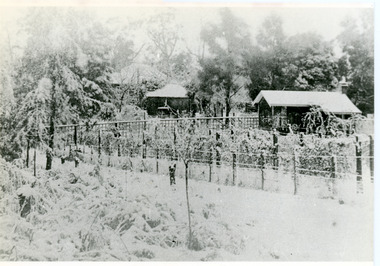
Erith Lane would have been named after Eliza Erith, the wife of Thomas Hand of Mountain Grange. The house made of slabs and bark pictured (centre) is where the family lived before Mountain Grange was built. Mabel Hand, Thomas and Eliza's youngest daughter stated that she was born in the bark hut in 1881 and they moved into the new home the same year. Cherry Farm, the roof visible behind the centre building, was the home of William Hand, son of Thomas and Eliza. He lived here with hs wife, Harriet Toghill, before moving to live at Mountain Grange after 1905.Black and white photograph showing a scene under heavy snow. Two cottages and a rooftop visible. Snow laden vines forming the front fence. Taller trees visible in the background. Reverse of photograph has handwritten description by John Lundy-Clarke.Erith Lane under snow. House in passion fruit Ivory’s holiday home 1921. Building in centre was Hand’s 28’ by 22’ house of slabs and bark. The first house on top of the whole Dandenong Range built 1871. Large roof behind it was “Cherry Farm”.eliza erith, eliza hand, mabel hand, thomas hand, william hand, erith lane, kalorama, snow, mountain grange, cherry farm, harriet toghill -
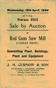 Bendigo Historical Society Inc.
Document - IAN DYETT COLLECTION: AUCTION CATALOGUE - RED GUM SAW MILL (CAELLI BROS.)
Two auction catalogues for a sale of Red Gum Saw Mill (Caelli Bros.) of Sawmilling Plant, Buildings, Plant and Equipment on 19th April, 1944. Contains descriptions of a number of the lots including a 3 roomed red gum slab house. J. H. Curnow & Son were the auctioneers.business, auctioneers, j h curnow & son pty ltd, ian dyett collection - auction catalogue - red gum saw mill (caelli bros.), j h curnow & son, j l jamieson, the cambridge press -
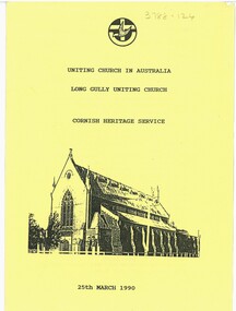 Bendigo Historical Society Inc.
Document - Long Gully Uniting Church - Cornish Heritage Order of Service 25 March 1990, 23/02/1986
The initial Methodist Church at Long Gully was a slab hut and in 1855 the first brick building was erected. This was replaced in 1865 by a brick church designed by architects Vahland and Getzschmann. In 1877 the present church, designed by the same architects was built, with the 1865 building becoming the Sunday school. A large part of the congregation was Cornish miners of whom there were large numbers in Long Gully and California Gully.A4 Sheet printed both sides of page, sketch of Long Gully Uniting Church on the front cover.religion, lydia chancellor collection, history, church -
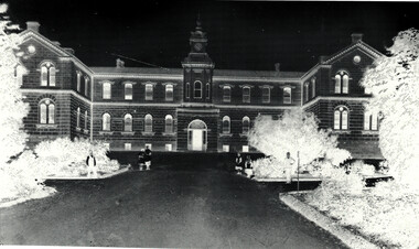 Bendigo Historical Society Inc.
Document - Bendigo Base Hospital, 1853-1970s
The hospital was first mooted in 1853. The first site chosen was "Hospital Hill" between Rowan and Mackenzie Streets and behind the present Lister House School of Nursing. The first building was a primitive affair of slab and weatherboard daubed with clay somewhere near the middle of the present Short St - which at the time extended to the brow of the hill behind the Sacred Heart Cathedral site. The new building was greatly need to serve the hundreds of diggers then active on the field. Messrs Vahland and Gezchmann, Architects, designed a new building of stone and brick, the cenre portion of the hospital to hold 100 beds. This centre portion cost 12,000 pounds and was erected in three months. Patients were transferred from the old site on Hospital Hill to the new building in December 1858.Black and White photo negative of the front of the hospital; Notes on the History of "The Bendigo Gold District Hospital"; letters re classification by the National Trust of Australia (Victoria).history, national trust bendigo collection, bendigo, bendigo base hospital, bnedigo hospital, bnedigo gold district hospital -
 Port Fairy Historical Society Museum and Archives
Functional object - Bath base, c. 1861
Hot water sea baths established in 1889 in Bank Street Port Fairy for separate men and women bathing. The bathes were closed in 1916. One bath was taken by Leo Brady when baths were demolished and used in his home until 1939. These items are from this bath.1. Metal bolt used to clamp slabs of marble for bath , from hot water baths. Bolt tapers from top to bottom and round knob on top. 2. Piece of white marble used in the sea baths - roughly triagular in shape. 3.Large piece of marble from the base of a sea bathlocal history, buildings, fittings -
 Port Fairy Historical Society Museum and Archives
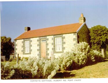
Photograph
65 Albert Road. the land was first owned by George Bull when he bought it in 1860. The house was built around 1862. Members of the family owned it until 1893 when it was sold to William Johnson. Johnson died in 1897 and Catherine Sara Ryan nee Hain bought it and lived there until she died in 1927. The cottage was then sold to the Coffey family who retained the property until 1974. The cottage is conventional coursed limestone building with bluestone quoins, gabled roof, chimneys at each end and a skillion on the western side, added at a later date. It was originally a two-roomed dwelling with kitchen. Behind the cottage is a slab-sided wooden gable ended shed, containing a large limestone rubble chimney and a sleeping area within the south facing skillion section. It is unlikely that it is older than the cottage, but it is an unusual, crude structure, presumably for general farming purposes.Coloured photographcottage, building, home, house, coffey's cottage, albert road, ryan, hain, johnson, george bull -
 Melton City Libraries
Document, The opp. shop song, Unknown
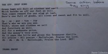
SUMMARY – Uniting Church Op Shop Melton South Opportunity Shop – Brooklyn Road Melton South Est 1975 Former Methodist Church. The Opportunity Shop – Established 1975 by Edna Barrie 1992 Typed copy by Cath MacLean 2011 [Scots’ Presbyterian Church 1964] Additional information to the above summarised from Edna Barrie’s draft notes. Copied by Wendy Barrie January 2012, noting the information might be useful for future research. In 1985 the need for more shop space became apparent. Les [Bone] had plans drawn up (Surv 12/8/84) and approved by the Melton shire Council for a storeroom extension (17.800 x 9500) 1986 the small ancillary rooms at the rear of the timber church were demolished allowing the concrete slab to be laid. The building was completed in 1987. By the early 1990s the old timber Church had deteriorated, this lead to it being demolished in 2/11/1993. It was replaced with a new building containing a Pastoral Office, a meeting room and a furniture and homeware section. It was dedicated by Rev Ian Hickingbotham at 11am Sunday 5th June 1994. Service Awards were presented to 75 Opportunity Shop Volunteers by Rev Ian Hickingbotham. Funds have helped to pay for pastoral work, youth work and extra pastoral support. Lyrics for the Opportunity Shop which was located at the former Methodist Church. council, churches, local identities -
 The Beechworth Burke Museum Research Collection
Card - Index Card, George Tibbits, Ford Street, Beechworth, 1976
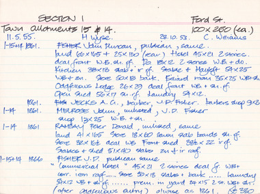
Property - Ford Street Beechworth - Section 1, Town Allotment 14 & 15 - 100' x 250' each Ownership details and history - 28 Oct 1853 - C. Williams - 11 Nov 1855 - H. Wyse 1-15&14 - 1861 - Fisher, John Duncan - publican, same. Land 66'x165' + 25'x130' (rear) Hotel 45'x21' 2 stories, deal front WB. sh. rf. Do 18'x12' 2 stories WB & Do. Kitchen 38'x13' slab + ir rf. Stable & Hayloft 54'x25' WB & sh. Store 50'x18' bark. Billiard room 35'x25' WB + sh. Oddfellows Lodge 26'x29' deal front WB + sh. rf. Open shed. 56'x17' sh. rf. Laundry 54'x12'. 1861 - Jecks A.G. barber, J.D. Fisher barbers shop 9'x8' 1-14 - 1861 - Melrose, John, unlisted J.D. Fisher shop 13'x25' WB + sh. 1-14 - 1861 - Ramsay, Peter Donald, unlisted, same, land 41'x165' store 18'x60' sawn slab boards sh. rf. store 32'x 16'6"deal WB Front Shed 38'6"x 22' ir rf. 1-15+14 - 1863/4 J.D. Fisher, Hotel as 1861 except store 50'x18' is detached and a shop above De Jecks & Kaliton of a 2 storey residence. 1863/4 - Jecks as above 1-14 - 1863/4 Ramsay - as 1866 1-14 - 1866 - Fisher J.D. - publican, same, "Commercial Hotel" 45'x21' 2 stories deal fr. WB+ corr. Iron roof..... store 50'x18' slabs + bark .... laundry 54'x12' WB + sh. rf. ..... prem. in yard 24'x15' 2 stories WB = sh. (after Oddfellows entry) 0/wise as 1861. £330 1-14 - Jecks A.G. barber, J.D. Fisher, barbers shop 9'x8' £28 1-14 - 1866 - Muirhead, George, Tailor, J.D.Fisher prem 13'x12' WB + Sh. £26 1-14 - 1866 - Ramsay P.D. Spirit dealer, same land 41'x165' front prem 23'x54' bk & ir. rf. Do in rear 32'x16'6" deal fr. WB + sh. rf. Do 8'x8' do---do. Stables + shed 51'x40' slabs, sh+ir. rf. (as1861) £35 1-15+14 1871 - Tanwell, Thomas, publican, same - Hotel as above except. Kitchen 40'x15' bk+iron roof as 1863/4 1861 1-14 - 1871 - Jecks, A.G., T. Tanswell, shop 11'x9' £15 1-14 - 1871 - Goodwin, George, watchmaker, T. Tanswell, sh. 12'x11' £19 [these two were actually entered before 1-14+15] 1-14 - 1871 - Scott, Robert, Wine & Spirit Merchant, P.D. Ramsay land 41'x165' deal fr. WB + sh. rf. Stable & shed 51'x40' slabs + iron roof. 1-15+14 - Tanswell, Thomas, publican, same, land 66'x135' + 25'x130' Hotel front buildings. 65'x35' brick, Back do. 42'x30' brick 2 stories iron roof. Kitchen 40'x15' bk. iron roof. Club room 26'x29' WB. sh. rf. Billiard room 35'x25' WB ir. rf. Prem in yard 24'x15' 2 stories WB sh. rf. Laundry 54'x12' WB sh. rf. Store 50'x18' slabs bark rf. Stables 54'x25' WB sh. rf. Shed 56'x17' £250 1-14 - 1876 - Jecks, A.G. barber T. Tanswell shop £15 1-14 - 1876 - Tanswell, T. publican, same, shop & room in rear £20 1-14 - 1876 - Crawford, Hiram Allen, Connelly, Michael, coach proprietors, Beechworth U.S. Council. Weighbridge £10 1-14 - 1876 - Crawford & Connolly, as above, T. Tanswell. prem as 1871. "23'x55'" & no deal fr. ou prem in rear £52 1-15+14 - 1884 - Tanswell E. Tanswell T. Hotel as above, hotel, billiard clubrooms etc. 1-14 - 1884 - Crawford H.A. - Jackson P.W. - McCurdy W. coach props., B.U.S.C., Weighbridge 1-15+14 - 1884 - Crawford H.A. coach props, T. Tanswell, Commercial stable (at rear) 1-14 - 1884 - Crawford H.A. coach prop, same, office, store, cellar & prem. 1-15+14 - 1889 - Tanswell, Edward. Hotel keeper, T. Tanswell, Comm Hotel Billiard Club + sample rooms, prem + land £175 1-15+14 - 1889 - Crawford, H.A. - Connolly, Thomas - McCurdy, William, coach props, same, Stables, Coach sheds, prems + land £80 1-14 - 1889 - Crawford & Co Ltd., coach props, T. Tanswell, office, store, prem + land £50 1-14 - 1889 - As above. B.U.S.C. Weighbridge £10 1-15+14 - 1900 - Crawford & Co ltd. coach proprietors, excecutors of Tanswell's, stables, offices, coach sheds, factory, land £130 1-15+14 - 1906 - Tanswell, Jane, hotelkeeper, same, hotel, prem + land £150 1-15+14 - 1906 - Tanswell, Jane, Clubrooms, Comm. Hotel £20 1-15+14 - 1906 - Crawford & Co LTD. coach props, Jane Tanswell, stables offices, coach sheds, factory + land £85 Architectural Index Card - Brian Pump and Tony Dugan - Photographers beechworth, george tibbits -
 The Beechworth Burke Museum Research Collection
Card - Index Card, George Tibbits, Ford Street, Beechworth, 1976
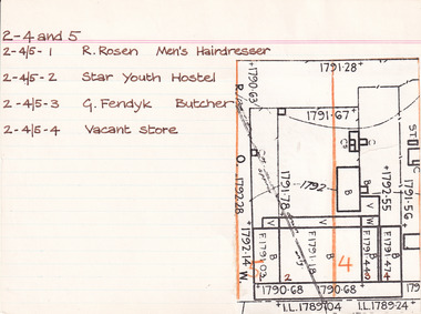
Property - Ford Street, Beechworth - Section 2, Town Allotments 4 - 100' x 250' - Note: (see also Town Allotment 5, 2-4/5-1, 2-4/5-2, 2-4/5-3 and 2-4/5-4) Ownership details and history - 28 Oct 1853 - W.H. Neuber 2-4+5 - 1861 - Wallace, Peter, unlisted, J.A. Wallace, I. 105'x165' Hotel 86'x21', 2 Stories WB. sh. rf. Dp. 84'x18' do----do. Theatre 75'x26' do. Office 18'x20' do, Billiard room 35'x22' sl. & sh. rf. Kitchen 45'x25' slabs, Back Bldg. 22'x15' do. Stables 60'6"x 20'6" do. 2-4 - 1861 - Hearn, William, unlisted, J. Gray, land 13'6"x25' shop 13'6"x25' plate glass fr. WB. + sh. rf. 2-4+5 - 1863/4 - Clark, J.S. Publican, same, land 105'x165' Hotel & bedrooms 105'x18', 2 stories WB. + sh. rf. Store at back 10'x24' Stables, slabs, battenwork, + sh. 113'x26' Kitchen 45'x25' slabs + bark rf. Store 14'x9' WB + bark, Ldry 11'x10' WB + sh. Theatre 75'x26' WB + sh. 2-4 - 1863/4 - Richter, A. Mrs Gray, bld 13'6"x25' shop as above 2-5 - 1866 - Brown, John, barber, J.S. Clark, shop + back rooms, 18'x16' part "Star Hotel Bldgs" £55 2-4 + 5 - 1866 - Clark, John Sitch, publican, same. land 105'x165' "Star Hotel" 61'x41' 2 stories bk bldg + sh. rf. Bedrooms from front along "Star Lane" 105'x18' 2 stories WB + sh. rf. In rear store 24'x10' slabs + sh. rf. Kitchen 45'x25' slabs + bark rf. Ldry 11'x10' WB + sh. Store 14'x9' W.B. + bark rf. £330 2-4 - 1866 Clark, J.S. Publican, same, 'Theatre" 75'x26' WB + sh. roof £70 2-4 + 5 - 1866 Crawford, Hiram Allen - also 16-17, Connolly, Michael, coach owners, J.S. Clark "Star" stables 120'x26' slabs trellis work & sh. rf. £30 2-4 - 1866 - Richter, Augustus, Watchmaker, William Telford, land + Prem as 1861 £52 no entry - 1871 - Isaacs, Alfred, Clothier, J.S. Clark, shop 18'x18'. part of Star Hotel Buildings 2-4 + 5 - 1871 - Clark, J.S. Publican, same hotel as 1866 £300 no entry - 1871 - Clark, J.S. Publican, same, coach office 14'x12' part of old Star Theatre £20 no entry - 1871 - Brasch, Morris, Clothier, J.S. Clark, shop 14'6'x50' part of old Star Theatre, £65 2-4 + 5 - 1871 - Clark, J.S. Publican, same, Stables 120'x26' slabs + sh. roof. £26 2-4 - Richter, A. Watchmaker, Wm. Telford, land + prem as 1861 £45 no entry - 1876 - Issacs, Alfred, tailor, F.K. Allen, shop and dwelling, part of Star Hotel Bldgs, £40 2-4 + 5 - 1876 - Allen, Frederick K. Hotelkeeper, same. land + hotel as 1866 + coach office part of old Theatre £160 2-5 - 1876 - Crawford, H.A. - Connolly, M. Coach Proprietors, F.K. Allen stables, 120'x26' slabs + sh. roof £78 no entry - 1876 - Galbraith, Andrew L. Confectioner, F.K. Allen, double shop 15'x50' part of old Star Theatre £65 no entry - 1876 - Richter, Augustus, Watchmaker, W. Telford, J.G. Orr. land + prem as 1861 £40 no entry - 1884 - O'Connor, David M. Hairdresser, shop + prem, portion of Hotel Bldg 2-4 + 5 - 1884 - Allen, F.K. Publican, same "Star Hotel" 2-4 - 1884 - William, Robert, Bootmaker, F.K. Allen - double shop 2-4 - 1889 - Crawford, Connolly & McCurdy, Coach Proprietors, F.K. Allen, Star Stables, Sheds + Land £60 2-4 - 1889 - Dunn, Fred, Bootmaker, F. Allen, shop, prem + land £15 2-4 + 5 - 1889 - Carroll, Wm. Hotelkeeper, F. Allen, Star Hotel. prem + land £135 2-4 - 1889 - Williams, Robert, Bootmaker, F. Allen, double shop + prem + land £40 2-4 - 1900 - Philips, William R. Blacksmith, Wm. Carroll, Star Stables and land £25 2-4 - 1900 - _unoccupied) , William Carroll, land £5 2-4 + 5 - 1900 - Lowe, John, Hotelkeeper, Wm. Carroll, Star Hotel premises £130 2-4 - 1900 - Vandenberg, George, Dentist, H. Vandenberg, surgery + land £10 2-4 - 1906 - Lod, Wm. G. Star Lane, Blacksmith, execs. W. Carroll, Star Stables and land £20 2-4 - 1906 - Dumbrell, Starr & Jarvis, Watchmakers, execs. W. Carroll, shop + land £40 2-4 + 5 - 1906 - Lowe, John. Hotelkeeper, W. Carroll execs. of Star Hotel and land £130 2-4 - 1906 - Vandenberg, Henry, not tenant issued, land £10 Note: execs. = executors 2-4 and 5 - 1976 2-4/5-1 - R. Rosen - Men's Hairdresser 2-4/5-2 - Star Youth Hostel 2-4/5-3 - G. Fendyk, Butcher 2-4/5-4 - Vacant Store Architectural Index Card - Brian Pump and Tony Dugan - Photographers beechworth, george tibbits -
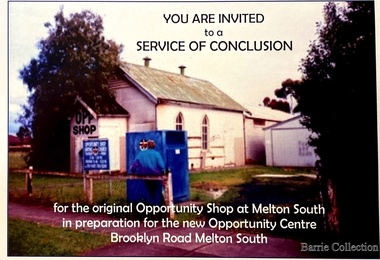 Melton City Libraries
Flyer, Melton South Uniting Church Opportunity Centre, 2016
The Opportunity Shop – Established 1975 by Edna Barrie 1992 In 1985 the need for more shop space became apparent. Les [Bone] had plans drawn up (Surv 12/8/84) and approved by the Melton shire Council for a storeroom extension (17.800 x 9500) 1986 the small ancillary rooms at the rear of the timber church were demolished allowing the concrete slab to be laid. The building was completed in 1987. By the early 1900s the old timber Church had deteriorated, this lead to it being demolished in 2/11/1993. It was replaced with a new building containing a Pastoral Office, a meeting room and a furniture and homeware section. It was dedicated by Rev Ian Hickingbotham at 11am Sunday 5th June 1994. Invites to the service of conclusion of the original Uniting Church Opportunity Centre and official opening to the new shop in Melton Southchurches, local identities -
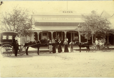 Charlton Golden Grains Museum Inc
Photograph, Clarke Bros Photographers, Klug's East Charlton Hotel c. 1892, c.1892
... commercial building in 1875 - a slab and bark inn 100 metres... commercial building in 1875 - a slab and bark inn 100 metres ...East Charlton Hotel High St Charlton c. 1892. Proprietor C. Klug. Established by John Flug who built Charlton's first commercial building in 1875 - a slab and bark inn 100 metres to the rear of this building. Photo taken by Clark Bros, Windsor, MelbourneBlack & white photo, mounted, postcard size. Signage Klug's on top of the building, East Charlton Hotel below that. Four men standing on footpath, four women and a man holding a dog standing on the road. On the left is a horse and covered buggy with a man standing in front of the buggy. There is a boy sitting in the buggy holding the reins. On the right is an open gig with a man and two women in it.c. klug, john flug, clark bros, east charlton hotel, business, industry -
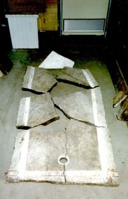
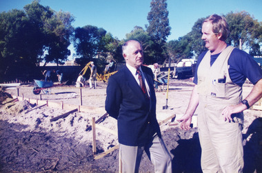 Lakes Entrance Historical Society
Photograph - Childcare Centre, Lakes Post Newspaper, 1997
Built on former site of Primary School pine plantation.Colour photograph of the laying of the foundation slab for the Lakes Entrance Child Care Centre, at 45 Coates Road. Councillor Ray Hack and builder Phillip Baade discussing progress. Lakes Entrance Victoriapublic utilities, buildings -
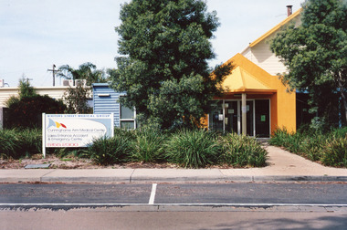 Lakes Entrance Historical Society
Photograph - Medical Centre, Holding M, 2009
Date made September 2009 Site building was originally (games room) part of caravan park Also one other colour photograph closer view of front entrance doorway.Colour photograph of the front entry to Cunninghame Arm Medical Centre at 8 Whiters Street. Appears to be brick or concrete slab facade painted bright yellow. Information sign in native plant garden, brick pathways. Lakes Entrance Victoriamedical facilities, local history -
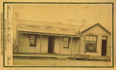
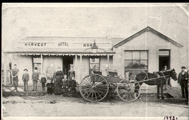 Bacchus Marsh & District Historical Society
Photograph, Harvest Home Hotel Main Street Bacchus Marsh c.1880s-1890s
The Harvest Home Hotel was licensed as a beer shop in 1866. Patrick Vallence was the licensee. On his death in 1874 his widow Mrs M. A. Vallence obtained the license. The date that this image was created has not been identified. Around 1883 George Marshall was leasing the hotel. The people in this image are could be members of the Marshall family and some of the staff who worked in the hotel at this time. Following a decrease in the population of Bacchus Marsh by 1911 the hotel had lost its licence. The Vallence family still owned the building after the loss of the hotel license in 1911and it was used for some years after this as a private residence by some members of the Vallence family. Small black and white photograph. The image depicts the Harvest Home Hotel situated in Main Street Bacchus Marsh. The name of the hotel can be seen above the verandah roof. The building appears to be of stone with decorative stonework corners. A verandah is inset to the left of a gabled front section which has its own door and window. A deep gutter runs along the front of the hotel, with a slab acting as a bridge to the road. Standing in front of the building facing the camera is a group of adults and children, men and women and boys and girls. A four seated buggy drawn by a single horse is also present in the image. The lantern erected above the horse trough can be seen.hotels bacchus marsh, vallence family bacchus marsh, marshall family bacchus marsh, harvest home hotel bacchus marsh -
 Eltham District Historical Society Inc
Photograph - Digital Photograph, Alan King, Graves of Thomas Sweeney and family, Eltham Cemetery, Victoria, 27 January 2008
The grave of Thomas Sweeney, former convict turned respectable citizen. The Murray and Sweeney families were both early settlers of the Eltham district and connected by marriage. Their family plots are located side by side in the Catholic section of the Eltham Cemetery. Irish-born Thomas Sweeney is regarded as the first settler in Eltham. He was transported to Sydney in 1823 after being convicted of arson. He was granted his freedom in 1838 and married Margaret Meehan in the same year. They moved to Melbourne and in 1842 Thomas purchased 110 acres beside the Yarra River in the vicinity of present-day Sweeneys Lane. He called the property ‘Culla Hill’ and built a small slab hut (reputedly with Wurundjeri help; Margaret is said to have run an informal hospital for them in return). This was followed in 1846 by more substantial buildings consisting of a three-roomed Irish-style ‘longhouse’ and a barn made of stone and handmade bricks, with doors large enough to accommodate a fully loaded wagon. When the gold rush came, Thomas prospered by selling meat and potatoes to the prospectors, enabling him to purchase a further 308 acres in 1856. He promoted the construction of a bridge over the Plenty River and the establishment of a school at Eltham. Roman Catholic Church services were held at Culla Hill in the early years. When he died in 1867, he was regarded as a respected member of the community. Thomas and Margaret are buried in Eltham Cemetery with many of their descendants. Their first son John continued to farm Culla Hill until his death in 1909. Culla Hill passed out of the Sweeneys' possession in 1939. The house and barn remain today, though lesser outbuildings have gone. The facade of the house is much the same as it was in the 1840s. Sacred To the memory of Thomas Sweeney Who died Sep 6th 1867 Aged 65 years May his soul res in peace Also his wife Margaret Died Oct 3rd 1884 aged 73 years And their daughters Annie Died Aug 22nd 1860 aged 21 years Johanna Died Aug 19th 1872 aged 22 years Margaret Died 7th Sep 1913 aged 72 years R.I.P. Also In Memory Of John Sweeney Died 24th May 1909 Aged 65 years Also of his wife Ellen Died 8th March 1910 Aged 64 years R.I.P Also In Memory Of Caroline Infant daughter of John & Ellen Sweeney Published: Nillumbik Now and Then / Marguerite Marshall 2008; photographs Alan King with Marguerite Marshall.; p55 From the piety and poverty of 19th century Eltham, 20th century artists and environmentalists, to today’s comfortable middle class, Eltham Cemetery records it all — and more. A visit to Eltham Cemetery reveals an important social record since its beginnings in 1858. The cemetery was situated on about six acres (2.4ha) (now around 4.8ha) at the corner of Mount Pleasant and Metery Roads.1* It is thought that Metery Road was originally called Cemetery Road, but in the early 1940s, a resident, possibly a councillor, objected to the name resulting in the change.2 Much can be gleaned about the developing Eltham community from burial styles and the names of former local residents. Originally the cemetery was divided into Christian denominations, like others of that time, following the United Kingdom burial system. In 1861 the cemetery included Church of England, Presbyterian, Roman Catholic and Wesleyans (later Methodist) sites. Graves also indicated social class. Some had grand tombstones, perhaps fenced with ornamental cast iron railing, but most in the 1860s and 1870s were constructed of modest stone slabs.3 This indicated the poverty of the district, which was largely inhabited by farmers on small landholdings. A poignant reminder of the high rates of infant mortality of those times, are the many infants and young children recorded on the headstones. Major changes occurred in the cemetery in the late 20th century as Christian adherence weakened and society became more egalitarian and informal. In the early 1970s a non-denominational lawn section for burials was established. Since then all new areas have been non-denominational to accommodate the more diverse local community. Now, instead of large ornamental headstones, some mourners have chosen boulders, reflecting the natural Eltham style, while others choose graves in the lawn areas or niches in walls. In the late 1970s, the University Donor Section was established north-west of Candlebark Lawn for those who donated their bodies for The University of Melbourne medical research. In the early 1980s the natural Australian garden style, popular in Eltham, was mirrored in a new section called Ashes Walk. Local landscape architect Gordon Ford, who had popularised this style, designed the Walk using boulders shaded by native plants beside curved pathways. Landscape architect Robert Boyle later redesigned Ashes Walk and developed other parts of the cemetery in keeping with this style.4 Appropriately Ford, who died in 1999, was interred in the Native Garden Section in a cluster of sites shaded by a large eucalyptus tree.5 By 2007, about 6400 interments were recorded in the Eltham Cemetery. Close inspection reveals notable names in the district’s history. The grave of Thomas Sweeney, a former convict who became a respected citizen, can be found in the Roman Catholic section near the path. Eltham Primary School’s first headmaster, David Clark, is buried in a modest grave in the Church of England section to the east of the path from the main entrance. Sir William Irvine, Victorian Premier from 1900 to 1902, whose grave is in the north-east Presbyterian section was at various times Victoria’s Chief Justice, Deputy Governor and Treasurer.6 Further south is the grave of social reformer Bertram Wainer, born in Scotland in 1928 and died in 1987. He campaigned to legalise abortion and exposed police corruption in allowing illegal ‘backyard’ abortions. Other prominent local residents interred in the cemetery include: Justus Jörgensen, who founded Montsalvat; Alistair Knox, the mud-brick housing pioneer and Eltham Shire Councillor from 1971 to 1975 and President in 1975; Clem and Nina Christensen, who had a major influence on the literary development of post World War Two Australia. Others were: composer Dorian Le Gallienne; artist Peter Glass; Stephen Dattner, a prominent Melbourne furrier; ALP parliamentarian for Greensborough, Pauline Toner and political scientist and commentator, Professor William Macmahon Ball.This collection of almost 130 photos about places and people within the Shire of Nillumbik, an urban and rural municipality in Melbourne's north, contributes to an understanding of the history of the Shire. Published in 2008 immediately prior to the Black Saturday bushfires of February 7, 2009, it documents sites that were impacted, and in some cases destroyed by the fires. It includes photographs taken especially for the publication, creating a unique time capsule representing the Shire in the early 21st century. It remains the most recent comprehenesive publication devoted to the Shire's history connecting local residents to the past. nillumbik now and then (marshall-king) collection, annie sweeney, caroline sweeney, ellen sweeney, eltham cemetery, graves, gravestones, johanna sweeney, john murray, john sweeney, margaret sweeney, mary ellen drain, mary murray, thomas murray, thomas sweeney -
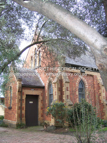 Eltham District Historical Society Inc
Photograph - Digital Photograph, Marguerite Marshall, Uniting Church, Main Road, Eltham, 19 August 2008
Eltham's original Wesleyan Methodist Church Covered under Heritage Overlay, Nillumbik Planning Scheme. Published: Nillumbik Now and Then / Marguerite Marshall 2008; photographs Alan King with Marguerite Marshall.; p97 The pretty Uniting Church building at the corner of John and Main Roads Eltham has served the community since 1881.1 Originally called the Eltham Wesleyan Church, the church became the Eltham Methodist Church in 1902, the year it united with the Primitive Methodists.2 As the church community developed, influencing and being influenced by the wider community, its buildings changed accordingly. Eltham Wesleyans first worshiped together in 1850 at the home of William and Mary Crozier on 24 acres (9.7ha) bounded by Mount Pleasant Road and Pitt Street. From 1855 the Wesleyans worshipped in a slab-and-bark hut; then in 1858 in a chapel on Henry Street close to Maria Street (now Main Road). Meanwhile, in 1860, the Primitive Methodists opened a brick chapel at the corner of Susan and Bridge Streets. The John Street building – in the Early English Gothic style with biochrome brick window frames, buttress heads and pinnacle – was designed by architects Crouch and Wilson. Church member George Stebbing built the church as he did Eltham’s St Margaret’s Anglican Church and Shillinglaw Cottage. The Church Honour Roll is a poignant reminder of how church members have served the wider community: 27 members enlisted and 11 died in World War One. Despite the Great Depression, 1931 was a time of expansion for the church. Its red-brick hall was opened by prominent Methodist and philanthropist F J Cato of the Moran and Cato Grocery chain. The hall enabled the church to attract people from outside through activities like its gymnasium – with 40 boys and youth participating – and the girls’ callisthenics club, which competed at the Ballarat South Street Competitions. The church also held concerts, bazaars, picnics and sports, with badminton and tennis played on the church court at 23 John Street. Two stained-glass windows commemorate tragic events. A dove representing the Holy Spirit and Comforter marked the death in 1936 of member Effie Lowerson from scarlet fever at 14 years. The other depicting the Biblical story A sower went forth to sow, commemorates Ross Gangell, who died in 1961 at 23 years of a rare blood condition. Eltham’s population expanson resulted in the growth of the church and an extension in 1971, designed by member and architect Colin Jones. The church was linked to the hall and additions included a foyer, vestry, meeting room and toilets. The design reflected the Eltham style of the time, with its simplicity, extensive clear glass, reused baked clay-bricks from the 1881 church, heavy ceiling beams and solomite (compressed straw) ceiling. On June 26, 1977 the church became part of the new Uniting Church in Australia consisting of the former Methodist and Congregational and most of the Presbyterian Churches. In 1981 membership peaked at 159 – about 20 years after most Protestant churches – and continued to reach out to the wider community.3 In 1987, 147 children attended Selihoo, the weekly after-school program organised with St Margaret’s Anglican Church. From 1993, the church with other local churches, participated in LINC (Love in the Name of Christ), helping the wider community in various ways including babysitting, transport, gardening and visiting. Despite such initiatives, church numbers declined, and on June 23, 1996, the church merged with the Montmorency Uniting Church.4 However, the church continued to proclaim its message of love in community service and strong social justice action, such as in Jubilee 2000, supporting debt relief to the world’s 45 poorest countries. Some of the many church members who have had an outstanding impact on the wider community include Philip Shillinglaw, farmer and poet, and Arthur Bird (after whom the Arthur Bird Reserve is named), a pioneer orchardist and the Sunday School Superintendent for 33 years. Others were: the Rev Dr Cliff Wright, who established the Methodist Youth Fellowship and was prominent in the World Council of Churches, the Rev Brian Howe, who became Deputy Prime Minister and Tim Marshall, awarded the Order of Australia in 2000 for his work on salinity.This collection of almost 130 photos about places and people within the Shire of Nillumbik, an urban and rural municipality in Melbourne's north, contributes to an understanding of the history of the Shire. Published in 2008 immediately prior to the Black Saturday bushfires of February 7, 2009, it documents sites that were impacted, and in some cases destroyed by the fires. It includes photographs taken especially for the publication, creating a unique time capsule representing the Shire in the early 21st century. It remains the most recent comprehenesive publication devoted to the Shire's history connecting local residents to the past. nillumbik now and then (marshall-king) collection, eltham uniting church, eltham methodist church -
 Eltham District Historical Society Inc
Photograph - Digital Photograph, Marguerite Marshall, Former home of Alistair and Margot Knox, King Street, Eltham, 16 January 2006
Situated in King Street, Eltham, Alistair Knox built his home and office in 1962-1963 with mud-bricks made from the local soil and recycled materials blending the house with bush around it. Knox popularised the Eltham earth building movement, begun by Montsalvat founder, Justus Jorgensen. Alistair Knox (1912-1986) was also an Eltham Shire Councillor 1971-1975 and Shire President in 1975. Knox established the inaugural Eltham Community Festival in 1975. Covered under Heritage Overlay, Nillumbik Planning Scheme. Published: Nillumbik Now and Then / Marguerite Marshall 2008; photographs Alan King with Marguerite Marshall.; p145 Lack of money was a strong incentive for Alistair Knox to do what he did best when he built his house and office at King Street, Eltham in 1962-63. He used mud-bricks from local soil and recycled materials, characteristically blending the house with the bush around it. The result was a work of art. Knox popularised the Eltham earth building movement,1 begun by Montsalvat founder Justus Jörgensen. He was also an Eltham Shire Councillor from 1971 to 1975 and Shire President in 1975. For Knox mud-brick building was not just a building style, but a spiritual experience and a way of relating with nature. At 40 he rediscovered God and his building reflected his theological, political, philosophical and particularly environmental world view, which was far ahead of its time.2 He also contributed to building development in his use of concrete slab foundations when stumps and bearers were the norm. Knox was introduced to mud-brick construction in 1940 by Jörgensen, then shortly after, Knox joined the Navy. In 1946 Knox studied Building Practice and Theory at Melbourne Technical College (now RMIT University). There he befriended fellow student and artist Matcham Skipper who belonged to what was then called the Jörgensen Artists’ Colony. Knox decided to build an earth building in Eltham, partly because the post-war huge building demands resulted in expensive and scarce building materials. He asked artist Sonia Skipper for help who, with Matcham, had constructed mud-brick buildings at the Artists’ Colony. The simple rectangular low-lying house at King Street is framed by native plants and a 3.6 metres wide pergola surrounds the building. Wedded to the landscape, a door in every room at the perimeter, opens outside. The property also includes a forge, a small hut built by son Macgregor at 15, and a mud-brick tower for chickens. Building materials were foraged from a wide variety of sources. Some of the joinery material came from old whisky vats. When the Oregon of the highest quality ‘was put through the wood-working machines, it gave off a deep smell of whisky that made the whole atmosphere exotic and heady’.3 Amateur builders, including schoolboys from Knox’s Presbyterian Church, made some of the mud-bricks. But the building was finished with the professional help of Yorkshire builder, Eric Hirst. Inside, the light is subdued with the mud-brick, beamed timber ceilings and floors of slate, timber or orange-brown tiles. Skylights, with rich blue and red leadlighting, illuminate one entrance area and this feature is repeated as edging on the door. The centre of the house is like a covered courtyard, with rooms built around it. The central room, 11 metres x 7 metres, was built in the same proportions as Knox’s mud-bricks. Clerestory windows on four sides infuse the room with a soft light. A huge brick fireplace extends beyond one corner and opposite is a small one where timber can only be placed vertically. The slate for the floor was discarded from the Malthouse Brewery now used as a theatre in Southbank. In the middle is a large refectory table and benches that seat 18. Like much of the house, it is rugged, yet beautiful. Made of Western Australian Jarrah by Macgregor with a chain saw and an adze, it retains knot and nail holes. Each wall has an opening, 2.4 metres at the ends and 3.6 metres at the sides. Only one has doors and these concertina doors are made of the backs of old church pews. The main bedroom has an ensuite with a marble hand basin discarded from the Victorian Parliament building; and a dressing room, where two wardrobes of polished timber recovered from a tip are attached to the walls. Separate from the house is the strikingly original circular-shaped office made of bluestone sourced from the original Army campsite at Broadmeadows.This collection of almost 130 photos about places and people within the Shire of Nillumbik, an urban and rural municipality in Melbourne's north, contributes to an understanding of the history of the Shire. Published in 2008 immediately prior to the Black Saturday bushfires of February 7, 2009, it documents sites that were impacted, and in some cases destroyed by the fires. It includes photographs taken especially for the publication, creating a unique time capsule representing the Shire in the early 21st century. It remains the most recent comprehenesive publication devoted to the Shire's history connecting local residents to the past. nillumbik now and then (marshall-king) collection, alistair and margot knox house, alistair knox design, mudbrick construction, eltham, king street -
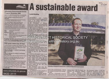 Eltham District Historical Society Inc
Document - Property Binder, 1184 Main Road, Eltham
Newspaper article: A sustainable award, Diamond Valley Leader, 1 November2006, Architect and building Llewellyn Pritchard won resource Efficiency Housing Award, finalist in HIA Greensmart Building of the Year Award. House – Environmental Leader (Published: Nillumbik Now and Then / Marguerite Marshall 2008; photographs Alan King with Marguerite Marshall.; p186) In 2006 environmental awareness was mushrooming in the community, which is reflected in the award-winning house at Main Road near Wattletree Road, Eltham. At first sight, the building appears a mix of a classic Eltham mud-brick house and an avant-garde building style. The crown of solar panels stretching along the width of the curved roof, indicates that this is no ordinary house. In fact it signals a new building trend of minimal impact on the environment. Yet it utilises the environment with high technical expertise to achieve comfort and cut running and maintenance costs. In recognition of this, its designer/builder, Conscious Homes, won the 2006 National HIA Greensmart Resource Efficiency Award. For Conscious Homes director, Llewellyn Pritchard, this house reflects a philosophy, strengthened by his connection with Aboriginal culture, through his foster siblings. Pritchard believes the sustainable way indigenous Australians lived and their spiritual connection with land, demonstrates how humanity is part of the ecology. His interest in environmental design stemmed from growing up in bushy Eltham Shire, with its mud-brick tradition. This was followed by studying Architecture at RMIT in the early 1980s, and learning about passive solar design. Pritchard says this house demonstrates that environmental sustainability is not about sacrifice, but about exceptional levels of occupant comfort, savings in running costs and modern fittings and appliances.1 The solar panels on the north roofs are intentionally obvious to make a statement about what the building is doing. But inside the systems are hidden and interactive with conventional services, such as the underground water tank. The house is water and energy self-sufficient and at 12 squares is much smaller than conventional houses, to minimise resources. Yet it accommodates his family of four with three bedrooms, a living/dining and kitchen area and a bathroom/laundry. Importantly the building is designed to last hundreds of years, by being able to be modified as the need arises, such as for commercial use. In this way the structure minimises its environmental impact. The solid double mud-brick walls (which are insulated) include steel beams and supporting frame, allowing the future removal or alteration of any section. The materials are local, recycled and of low toxicity where possible.2 Inside and out, the mud-brick is rendered and sealed with a combination of cement and sand and a mud-based coating in a soft golden hue increases its life. Inside, the golden-brown timber is plantation Mountain Ash and the concrete floors throughout – of local stone aggregate with a clear seal – have a natural looking random stone appearance. The house sustains a stable temperature of around 20 degrees, assisted by the concrete slab floor. The many large double-glazed windows and highlights (windows set high on walls) provide cross-flow ventilation. The north-facing living area maximises heating from the lower winter sun and is cooler in summer, because the sun is higher. Heating comes from a solar hydronic slab system. All appliances and fittings are high efficiency energy or water rated. Appliances in the timber kitchen include a gas stove and a dishwasher, using the building’s own power and water. French doors open from the living area to a deck, concealing the treatment system for all waste water. This is pumped through sub-soil drippers to the indigenous garden beds and no-dig vegetable patch. Below the carport is the 80,000-litre rainwater tank and at the back, the boiler room houses the solar boiler, water tank access, domestic water supply pump, filter gear and hydronic slab heating controls. The solar system is backed up with gas, which is needed to heat water only in winter. Gas used is less than one quarter of that for an average home with ducted heating. Excess power is fed back to the grid and the building uses about one quarter of the mains electricity of an average home. Other local builders have followed Pritchard’s lead in resource efficiency for minimal environmental impact.main road, eltham, businesses, llewellyn pritchard, hia greensmart building of the year award., efficiency housing award, conscious homes australia pty ltd -
 Bacchus Marsh & District Historical Society
Photograph, Harvest Home Hotel Main Street Bacchus Marsh 1883
The Harvest Home Hotel was licensed as a beer shop in 1866. Patrick Vallence was the licensee. On his death in 1874 his widow Mrs M. A. Vallence obtained the license. At the time this image was taken George Marshall was leasing the hotel. Following a decrease in the population of Bacchus Marsh, by 1911 the hotel had lost its licence.The Vallence family still owned the building after the loss of the hotel licence in 1911and it was used for some years after this as a private residence by some members of the Vallence family. Small sepia unframed photograph on card with gold border framing photograph. Housed in the album, 'Photographs of Bacchus Marsh and District in 1883 by Stevenson and McNicoll', the Jeremeas Family Album. The image depicts the Harvest Home Hotel situated in Main Street Bacchus Marsh. The name of the hotel can be seen above the verandah roof. The building appears to be of stone with decorative stonework corners. A verandah is inset to the left of a gabled front section which has its own door and window. On either side of the door beneath the verandah can be seen boot or shoe scrapers. A deep gutter runs along the front of the hotel, with a slab acting as a bridge to the road. Situated in the gutter at the front of the hotel is a water trough which has an arch above it with an ornate lantern, probably to light the front entry and to enable horses to be watered at night. A hitching post is nearby.On the front: Stevenson & McNicoll. Photo. 108 Elizabeth St. Melbourne. COPIES CAN BE OBTAINED AT ANY TIME. On the back: LIGHT & TRUTH inscribed on a banner surmounted by a representation of the rising sun. Copies of this Portrait can be had at any time by sending the Name and Post Office Money Order or Stamps for the amount of order to STEVENSON & McNICOLL LATE BENSON & STEVENSON, Photographers. 108 Elizabeth Street, MELBOURNE. hotels bacchus marsh, stevenson and mcnicoll 1883 photographs of bacchus marsh and district, vallence family bacchus marsh, harvest home hotel bacchus marsh -
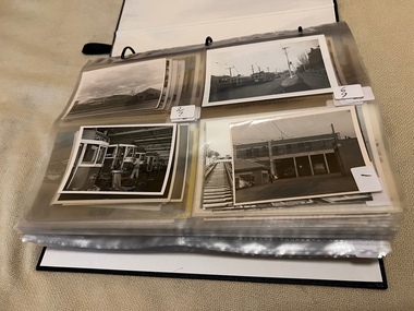 Melbourne Tram Museum
Album - Charles Craig - part 1 of 2, 1950s to 1970s
Photo - see pdf file for further information. Number Brief Description CC1 S178 at Elsternwick level crossing track works CC2 Building East Preston Depot 1955 CC3 Camberwell depot – post WW2 – lots of trams and a black cat CC4 W2 584 and SW6 958 northbound – Chapel St and Brighton Road CC5 W2 357 – southbound, Chapel St Brighton Road CC6 Pascoe Vale Road, Raceday working – note the signal CC7 The Preston Workshops - The Argus, post WW2, 223, 647 et al CC8 923 or is it 922 being built at Preston – The Argus photo - CC8A 832 being positioned onto trucks at Preston after an overhaul – Argus Photo – see also CC306 CC9 Footscray depot` CC10 W5 797 in St Kilda Road during track works – 1950s CC11 W2 457 at Kew Post Office CC12 Wellington Parade – W2 432, 492 and 337 – special event CC13 Swan St line up of trams – football? Or other special event – Sinclair’s bus on the right side. CC14 W2 630 being washed at a depot – The Argus photo CC15 Royal Park line at Flemington Road – W2 355 and W5 786 CC16 Nicholson St track construction from a tram cab CC17 T181 on tour at Gordon St CC18 T181 on Maribyrnong Bridge CC19 Ditto at River St just off bridge CC20 As for CC18 CC21 At Raleigh Rd CC22 T181 at Footscray depot CC23 Track construction, Nicholson, just north of Gertrude CC24 Commissioning overhead Bourke St tram 988 CC25 Queens Parade – 997 and 994 CC26 Swapping trolley wheel to skid – commissioning CC27 Track construction in Gertrude St CC28 985 in Queens Parade running special CC29 997 in Queens Parade CC30 1033 at North Fitzroy – AETA Special CC31 Bourke St at Elizabeth St – has passengers on board CC32 W6 985, 996 Queens Parade, Mk 3 bus 333 CC33 As above CC34 Showing construction at Nicholson & Gertrude – Bourke St CC35 W2 223 on Burnley temporary bridge – VR track expansion CC36 W5 823 – ditto CC37 Tram on old bridge prior to removal CC38 W2 433 on temporary bridge with new bridge beams and old track CC39 Looking down showing temporary single track – Swan St CC40 Tait train passing under tram bridge CC41 SW6 on single line – off loading CC42 W2 547 at City Road Junction CC43 City Road Jtn – 1969 – 596 and 771 CC44 City Road Jtn – 1969 – 596 and 771 (same as CC45 438 in Flinders St CC46 355 somewhere CC47 552 somewhere CC47A 364 at Preston Workshops? CC48 W2 334 on Traverser – Preston Workshops CC49 Wellington pade – large line up of trams, c1950 925, and 611 CC50 W2 493 Franklin st – advertising for Savings Certificates CC51 Possibly 551 with advertising for fund raising for Blind institute CC52 249 at Hawthorn – Riversdale Junction – with a Tally Ho and Village Fair Aux. board CC53 MMTB Postcard of 511 CC54 Wattle Park terminus with Single line warning sign CC55 Wattle Park Duplication CC56 36 at Domain Junction – 833 CC57 36 at Domain Junction CC58 36 at Domain Junction with 810 and 833 CC59 36 in Swanston by Flinders St Station CC60 36 in Spencer St at A’Beckett CC61 36 crossing Collins St CC62 36 crossing Collins St CC63 36 northbound in St Kilda Road with Shrine in background CC64 36 northbound in Swanston St at Flinders St CC65 Postcard – Ballarat 36 in Domain Road CC66 Postcard - Stampshow – Hawthorn Horse tram CC67 Postcard - Stampshow – Peace cable tram CC68 Postcard - 1041 and cable car set 1 at Preston CC69 Postcard - Colins & Elizabeth – greetings from old Melbourne CC70 Postcard - Cable car set at Preston CC71 Postcard - Twentyman’s cable cars CC72 Postcard - Nu-color-vue – horse tram 256 CC73 Cable car set – Market & Flinders CC74 Cable trams at Twentymans’ in their shed CC75 Cable tram track at Bourke & Spencer prior to removal CC76 Cable tram bogie at Preston Workshops – used as a dolly CC77 Cable trams at Twentymans’ CC78 Postcard - Valentines – Bourke looking west from Swanston CC79 Postcard - Rose 3938 – Bourke at Swanston – the Leviathan building CC80 Postcard - Valentines – Elizabeth St looking south from Collins – No. 19 CC81 Postcard - Rose P4765 – Bourke St Melbourne CC82 Postcard - Rose 4090 – cable tram passing Parliament house CC83 Postcard - Valentines – GPO Elizabeth St CC84 Interior of cable trailer with clothing on a set CC85 Elizabeth St looking north CC86 Cigarette card - Collins St No. 41- WD HO Wills CC87 Postcard - Rialto building with cable set CC88 Postcard - Valentines - Swanston at Flinders looking north CC89 CC90 Q 150 Hanna St – dated on rear CC91 176 turning – photo ex Alan Jungworth CC92 161 on Princes Bridge – minimum fare 4d sign and Inspector CC93 459 at Point Ormond CC94 158 at Gordon St – side on view CC95 X 217 in Swanston St CC96 X 217 in Swanston St with an East Brighton destination CC97 T177 CC98 T177 Peel St – no destination roll – being transferred? CC99 X1 462 in Glenhuntly Road to Point Ormond CC100 X1 462 in Glenhuntly Road to Elsternwick Rly Station CC101 X1 462 in Glenhuntly Road to Point Ormond CC102 Q 150 Hanna St CC103 190 at Camberwell Depot CC104 T182 at Footscray CC105 X1 466 and W2 at Footscray CC106 190 at Camberwell Depot CC107 X1 467 Barkly St Footscray CC108 X2 679 turning into William St from La Trobe St CC109 X2 677 Glenhuntly Road with Point Ormond Destination CC110 Postcard T180 CC111 Postcard format – X1 467 on a truck – see also CC178 CC112 Postcard format – X1 467 at Wantirna South CC113 Q200 and SW6 896 at Thornbury – has labels on rear CC114 T177, Ballarat Road – has labels on rear CC115 T178 at Point Ormond CC116 Postcard X1 465 and 466 CC117 Postcard – X2 676 CC118 Postcard – TMSV X2 217 CC119 810 on temporary bridging – 24-12-67 CC120 W2 575 – Queens Parade junction in, still temporary bridging, substation under construction CC121 Forming Queens Parade Junction base slab CC122 W2 596 prior to tramway works – all tracks still in position CC123 It’s a mass of reinforcing – bridging being formed CC124 Looking north with substation being built CC125 Looking east with some rather tight curves, Wellington St still in use CC126 SW6 958 ex Wellington St with all tracks and signal box and buildings. CC127 Victoria Pde at Gisborne looking east – at least 4 cars CC128 SW6 893? With dash canopy lights and SW6 862 and a man with a newspaper CC129 SW6 894 on the S curves, with tram in Wellington St CC130 Similar photo CC131 W2 564 turning into Wellington St – the concrete tracks are not that old CC132 W2 552 running out of Wellington St CC133 W5 732 from Fitzroy St into St Kilda Road with next iteration in position – very wonky CC134 W5 764 turning into Fitzroy St CC135 SW6 947 turning from Wellington St CC136 W2 586 running out of High St CC137 W2 500 turning into Wellington St CC138 W2 543 in Wellington St inbound CC139 L103 with St Kilda Junction destination, and a tower truck on right CC140 Workmen – new track in Queensway in use CC141 Ditto CC142 L103 in Queensway, and another car in bound CC143 Looking east along Wellington St which has been taken out of use. Also a MMTB Roller CC144 W5 824 and a W2 and all types of wobbly temporary track CC145 W2 354 to High St CC146 Sw6 947 on the S bends CC147 W2 500 looking north – tram on the S bends CC148 SW6 896 leaving the S bend CC149 W2 357 and a MMTB City bus with trees/gardens on the side CC150 W5 817 Elliot Ave – see also CC302 CC151 W2 552 – note the large trolley bridge CC152 W2 550 at depot or workshops CC153 1B truck CC154 SW2 432 CC155 W2 155 at Glenhuntly CC156 SW6 937 on AETA tour? CC157 X2 677 on Footscray service – Ballarat Rd? CC158 W2 641 – High St Kew? CC159 SW6 847 – Power St Hawthorn CC160 Simpson St – big line up CC161 W2 546 truck No. 1? CC162 W2s at Glenhuntly depot CC163 No. 15 truck under 899 CC164 206 and other junk at Preston Workshops CC165 W in Swanston St Melbourne – Rose series card CC166 Y1 613 Batman Ave?? or William St at Collins CC167 Tram plans CC168 X 217 Swanston St – see also 95 and 96 CC169 217 in Swanston St – same as 95 CC169A 192 in St Kilda Road at Princes bridge CC170 192 in St Kilda Road at Princes bridge CC171 Bendigo 3 arriving Malvern depot – being unloaded CC172 Ditto CC173 T180 at a depot CC174 X1 463 wheel set CC175 C30 – dog car side view – close up CC176 C30 dog car CC177 206 and 30 at Preston Workshops CC178 X1 467 on a truck – see CC111 also CC179 42 CC180 42 at a depot, no destination box CC181 W2 556 1A type truck CC182 Flinders St Station – Rose Series CC183 W7 1035 Spring – Nicholson St CC184 W7 1022 MMTB Post Card CC185 Adelaide 178 – has on rear – R. Lilburn 4/82 CC186 Adelaide 175 – has on rear – R. Lilburn 4/82 CC187 Y1 610 on AETA tour CC188 Y1 610 on AETA tour with large group – Point Ormond CC189 AETA display – has GH55-32 in pencil on rear CC190 AETA display – has GH55-29 in pencil on rear CC191 Y1 610 on AETA tour with large group – Point Ormond CC192 VR 53 at Footscray CC193 VR cars 40 and 34 at Elwood wash dock CC194 W7 1024 as the 1970 Christmas tram CC195 Geelong – loading a set of 22E trucks CC196 Geelong 10 and 23 running an AETA special CC197 Geelong – AETA special CC198 Geelong 7 at Junction CC199 Geelong 10, in the city CC200 Geelong 33 with Belmont destination CC201 Geelong 15 Eastern Park destination 29-3-1948 CC202 Geelong 23 at Railway Station – 29-3-1948 CC203 Geelong 23 at Railway Station – 29-3-1948 CC204 Geelong – loading a bogie tram CC205 Geelong – loading a bogie tram CC206 Geelong 40 – loaded on truck CC207 Geelong 40 – on jacks CC208 Geelong 40 on jacks – 19 behind CC209 Geelong 38 with two workers on either side CC210 – 214 Australian Historic Tramways stamp folder and set CC215 Bendigo 17 at depot – has dup JBS on rear CC216 Bendigo 20, 29 bogie and straight sill car at Charing Cross CC217 Bendigo one man bogie Pall Mall CC218 Bendigo – Bogie 23, other cars and welding truck at depot CC219 Bendigo 7 with Quarry Hill destination CC220 Bendigo 21 with Lake Weerona destination CC221 ESCo 18 Ballarat CC222 Ballarat bogie 22 on AETA special CC223 Ditto CC224 Ballarat 34 at Stones Corner – R Lilburn CC225 Ballarat 15 in Bridge St – R Lilburn CC226 Ballarat 40 at Gardens – R Lilburn CC227 Ballarat 37 running out of depot – R Lilburn CC228 Postcard – Valentines – Sturt St with loaded horse tram trailer CC229 AETA Geelong tram tour ticket – 29-3-1948 CC230 Postcard – Geelong – Valentine 2114 – T&G building CC231 Postcard – PMTT ! – High St Malvern CC232 Postcard – Empire – Glenferrie Road, Malvern at Wattletree Rd CC233 Postcard Y469, MMTB CC234 Postcard Z2 Spring St CC235 Postcard – Z1 MMTB CC236 Postcard – Stamp Show W1 431 CC237 Postcard – Stamp show B2005 CC238 Postcard – Stamp show W6 982 CC239 Postcard – Valentines 1264 – Johnstone Park with tram in distance CC240 Postcard – Rose 10711 – Swanston and Lonsdale – Hospital and W232 CC241 Postcard – Rose 4827 – Fitzroy St St Kilda W2 362 and 548 CC242 Postcard – Valentines – 939 – St Kilda War Memorial, W and a R? CC243 Postcard – Valentines – 572 – St Kilda War Memorial, W 413 and 140? CC244 Postcard – Valentines – 938 – Uper and Lower Esplanade – L 104 CC245 Postcard – St Kilda Rd at Princes Bridge Y1 and W CC246 Postcard – Biscay BG82 – W5 814 - CC247 Postcard – Biscay 796112 – Bourke St looking west CC248 Postcard – Biscay 796109 – Bourke St looking east CC249 Postcard – Biscay 2AUS58 – Z5 Bourke St CC250 Postcard – Biscay BG 249 – Swanston St CC251 Postcard – National View – St Kilda Rd – shrine and Prince Henrys W2 405 CC252 Postcard – Nu color vue – 11 ML 156 – St Kilda Rd CC253 Postcard – Nu color vue – 11 ML 153 – Swanston St CC254 Postcard – Nu Color vue – Collins St 442 CC255 Postcard – Pitt card – Adelaide – H 364 at Victoria St CC256 Postcard – SPER L/P 154 CC257 Postcard – BTMS – 550 CC258 Postcard – SPER – Brisbane 295 CC259 Adelaide 131 at Burnside – has R Lilburn on card, c1911 CC260 Adelaide 194 CC261 Adelaide 235, with two crew, The News photo CC262 Rockhampton, outside post office – has source of photo details CC263 Sydney – 2086 and 2062 arriving Circular Quay CC264 Sydney – P class – Pitt St? CC265 Sydney – 1610 at Circular Quay CC266 Brisbane 99 and 468 CC267 Sydney with bridge behind CC268 Steam tram Paramatta Park – 103 CC269 Sydney – Museum Station =- Elizabeth St CC270 Sydney – weed burner 137S at a loop Demonstrates the work of Charles Craig in photography and collection of prints.Assembled album in a black presentation folder of 270 photographs from the Charles Craig Collection - 86 sleeves - part 1 of 2. All photographs have been scanned and placed on the Museum's G drive. A list of all photographs with details where possible has been compiled. Victorian Provincial, Launceston, Hobart and Sydney tram photos have been transferred to other Museums, image files retained.melbourne, tramways, tramcars, trams, charles craig, st kilda junction, trackworks