Showing 4271 items
matching street plan
-
 Port Melbourne Historical & Preservation Society
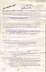
Plan - Metalling and channelling Evans Street from Ingles Street to Boundary Street, 14 Mar 1893
... Specifications (94.1) and Plan (94.2) for metalling... Engineering - Roads Streets Lanes and Footpaths Town Planning Town ...Specifications (94.1) and Plan (94.2) for metalling and channelling Evans Street from Ingles Street to Boundary Street . Loan Works 1893. Plan number 8.Both signed by J.J. Bartlett. (Mayor).engineering - roads streets lanes and footpaths, town planning, town clerks, mayors, arthur victor heath, james john bartlett -
Port Melbourne Historical & Preservation Society
Plan - Metalling and channelling Evans Street from Ingles Street to Boundary Street, 14 Mar 1893
... Specifications (94.1) and Plan (94.2) for metalling... Engineering - Roads Streets Lanes and Footpaths Town Planning Town ...Specifications (94.1) and Plan (94.2) for metalling and channelling Evans Street from Ingles Street to Boundary Street . Loan Works 1893. Plan number 8.Both signed by J.J. Bartlett. (Mayor).engineering - roads streets lanes and footpaths, town planning, town clerks, mayors, arthur victor heath, james john bartlett -
 Phillip Island and District Historical Society Inc.
Booklet, Cowes McRae Beach Estate, 1960s
... , including plan of streets and location on Island, photos... Beach Estate, including plan of streets and location on Island ...This land was owned by the McRae family, whose wife was a Justice. Hence the street names of McRae and Justice. The weatherboard family home [ originally a guest house called Glen Isle] was at the end of the current Justice Road. The estate was created in the mid 1960s. The house was put on skids and dragged by two tractors and a bulldozer to 364 Church Street while the family home was built at 368 Church Street, Cowes.[ Source Sandra Rocotas, nee McCrae. Facebook Community Noticeboard 5/2/2023. Permission given to use information and photos ] Estate was sold by Rogan Real Estate.HistoricalColoured A4 brochure describing the McRae Beach Estate, including plan of streets and location on Island, photos and description of the Island. Sold by Rogan Real Estate.Cowes McRae Beach Estate - Right in the heart of things .Phillip Island - The Loveliest Isle on Earthhousing, justice family, mcrae family, cowes west, rogan real estate cowes phillip island, glen isla -
 Federation University Historical Collection
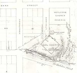
Plan, Ballarat Showing Gaol Reserve, 1857, c1857
... The portion of Lydiard Street depicted on this plan is now... The portion of Lydiard Street depicted on this plan is now part ...The portion of Lydiard Street depicted on this plan is now part of the Federation University Ballarat School of Mines (SMB) campus.Copy of an early plan of the former Ballarat Gaol Site.ballarat, ballarat gaol, ballarat gaol reserve, gaol reserve, ballarat courthouse, plan, gold diggings, smb campus, lydiard street south -
 Federation University Historical Collection
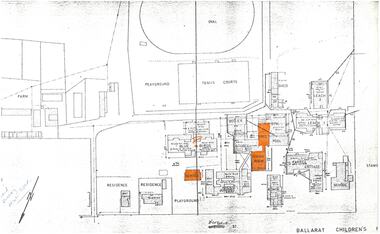
Plan, Plan of the Ballarat Children's Home
... Ballarat Orphanage) in Victoria Street. The plan names each... "Board meeting next Wed" Copy of a plan of the Ballarat ...Copy of a plan of the Ballarat Children's Home (formerly Ballarat Orphanage) in Victoria Street. The plan names each building, and identifies the oval, tennis courts, playground and farm. The hall, dining room and school have been highlighted in orange. The 'Blue Birds' building has an orange question mark over it. WGS 84 37degrees 33' 35" S 143 degrees 53' 10" EWritten in blue "Board meeting next Wed"ballarat children's home, ballarat orphanage, orphanage farm, farrel cottage, swimming pool, gym, leach building, school, infant school, junior's wing, administration, laundry, blue birds, superintendent's residence, assistant superintendent's residence -
 Kew Historical Society Inc
Plan - Subdivision Plan, Mount Ida Estate, 1925
... Street, and Mount Ida Avenue in Hawthorn East. The report.... On the other side of Constance Street, the plan identifies the ‘Eastern ...The Kew Historical Society collection includes almost 100 subdivision plans pertaining to suburbs of the City of Melbourne. Most of these are of Kew, Kew East or Studley Park, although a smaller number are plans of Camberwell, Deepdene, Balwyn and Hawthorn. It is believed that the majority of the plans were gifted to the Society by persons connected with the real estate firm - J. R. Mathers and McMillan, 136 Cotham Road, Kew. The Plans in the collection are rarely in pristine form, being working plans on which the agent would write notes and record lots sold and the prices of these. The subdivision plans are historically significant examples of the growth of urban Melbourne from the beginning of the 20th Century up until the 1980s. A number of the plans are double-sided and often include a photograph on the reverse. A number of the latter are by noted photographers such as J.E. Barnes.The Mount Ida Estate was a subdivision of fifty-two residential allotments bordering Tooronga Road, Leura Grove, Constance Street, and Mount Ida Avenue in Hawthorn East. The report of the sale of the Estate in The Argus (21 September) claimed that over 1,000 people attended the auction and that all allotments were sold on the day. On the other side of Constance Street, the plan identifies the ‘Eastern Recreation Reserve’ (now Anderson Park).subdivision plans - hawthorn -
 Kew Historical Society Inc
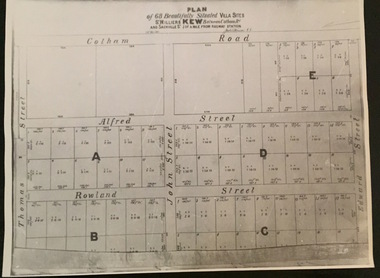
Plan - Subdivision Plan, Plan of 68 beautifully situated villa sites: St Helliers Kew, 196-1973
... and Thomas Street. The undated plan does not include the land.... Subdivision plans -- kew (vic) St Helliers Estate A photographic ...This work forms part of the collection assembled by the historian Dorothy Rogers, that was donated to the Kew Historical Society by her son John Rogers in 2015. The manuscripts, photographs, maps, and documents were sourced by her from both family and local collections or produced as references for her print publications. Many were directly used by Rogers in writing ‘Lovely Old Homes of Kew’ (1961) and 'A History of Kew' (1973), or the numerous articles on local history that she produced for suburban newspapers. Most of the photographs in the collection include detailed annotations in her hand. The Rogers Collection provides a comprehensive insight into the working habits of a historian in the 1960s and 1970s. Together it forms the largest privately-donated collection within the archives of the Kew Historical Society.A photographic reproduction of a plan in the Vale Collection of the State Library of Victoria. The plan shows lots in a subdivision bordered by Cotham Road; Edward Street; Sackville Street and Thomas Street. The undated plan does not include the land occupied by Bella Vista and Charleville.subdivision plans -- kew (vic), st helliers estate -
Port Melbourne Historical & Preservation Society
Document - Specification, Metalling and chanelling, Danks Street from Esplanade East to Boundary Street South, Engineering Department, Town of Port Melbourne, 14 Mar 1893
... Specification for metalling and channelling Danks Street... Engineering - Roads Streets Lanes and Footpaths Town Planning Town ...Specification for metalling and channelling Danks Street from Esplanade East to Boundary Street South (Pickles Street) Loan Works 1893 plan 19; relates to plan 98.2Signed by JJ Bartlett (Mayor) 14.3.1893engineering - roads streets lanes and footpaths, town planning, town clerks, mayors, arthur victor heath, james john bartlett -
Port Melbourne Historical & Preservation Society
Plan - Metalling and channelling Danks Street from Esplanade East to Boundary Street South, Engineering Department, Town of Port Melbourne, 14 Mar 1893
... Plan for metalling and channelling Danks Street from... Engineering - Roads Streets Lanes and Footpaths Town Planning Town ...Plan for metalling and channelling Danks Street from Esplanade East to Boundary Street South (Pickles Street) Loan Works 1893 plan 19; relates to specification 98.1Signed by JJ Bartlett (Mayor) 14.3.1893engineering - roads streets lanes and footpaths, town planning, town clerks, mayors, arthur victor heath, james john bartlett -
 Kew Historical Society Inc
Plan - Subdivision Plan, High Street, Kew, 1920-1935
... of a parcel of land bordering on High and Mary Streets. The plan shows... such as J.E. Barnes. subdivision plans - kew High Street -- Kew (Vic ...Pru Sanderson, in her groundbreaking ‘City of Kew Urban Conservation Study : Volume 2 - Development History’ (1988), summarised the periods of urban development and subdivisions of land in Kew. The periods that she identified included 1845-1880, 1880-1893, 1893-1921, 1921-1933, 1933-1943, and Post-War Development. These periods were selected as they represented periods of rapid growth or decline in urban development. An obvious starting point for Sanderson’s groupings involved population growth and the associated economic cycles. These cycles also highlighted urban expansion onto land that was predominantly rural, although in other cases it represented the decline and breakup of large estates. A number of the plans in the Kew Historical Society’s collection can also be found in other collections, such as those of the State Library of Victoria and the Boroondara Library Service. A number are however unique to the collection.The Kew Historical Society collection includes almost 100 subdivision plans pertaining to suburbs of the City of Melbourne. Most of these are of Kew, Kew East or Studley Park, although a smaller number are plans of Camberwell, Deepdene, Balwyn and Hawthorn. It is believed that the majority of the plans were gifted to the Society by persons connected with the real estate firm - J. R. Mathers and McMillan, 136 Cotham Road, Kew. The Plans in the collection are rarely in pristine form, being working plans on which the agent would write notes and record lots sold and the prices of these. The subdivision plans are historically significant examples of the growth of urban Melbourne from the beginning of the 20th Century up until the 1980s. A number of the plans are double-sided and often include a photograph on the reverse. A number of the latter are by noted photographers such as J.E. Barnes.A roughly drawn and faded actual or projected subdivision of a parcel of land bordering on High and Mary Streets. The plan shows five allotments facing High Street and at their rear, another allotment facing Mary Street. In 1906, when the Board of Works surveyors completed Detail Plan 1589, the allotment in Mary Street is shown to include a building. The section of land attached to this building is shown to be undeveloped, thus making a further subdivision possible.subdivision plans - kew, high street -- kew (vic.), mary street -- kew (vic.) -
 Kew Historical Society Inc
Plan, Melbourne & Metropolitan Board of Works : Borough of Kew : Detail Plan No.1572, 1905
... . Other streets identified on the plan include Stansell Street... features. Each plan covers one or two street blocks (roughly six ...The Melbourne and Metropolitan Board of Works (MMBW) plans were produced from the 1890s to the 1950s. They were crucial to the design and development of Melbourne's sewerage and drainage system. The plans, at a scale of 40 feet to 1 inch (1:480), provide a detailed historical record of Melbourne streetscapes and environmental features. Each plan covers one or two street blocks (roughly six streets), showing details of buildings, including garden layouts and ownership boundaries, and features such as laneways, drains, bridges, parks, municipal boundaries and other prominent landmarks as they existed at the time each plan was produced. (Source: State Library of Victoria)This plan forms part of a large group of MMBW plans and maps that was donated to the Society by the Mr Poulter, City Engineer of the City of Kew in 1989. Within this collection, thirty-five hand-coloured plans, backed with linen, are of statewide significance as they include annotations that provide details of construction materials used in buildings in the first decade of the 20th century as well as additional information about land ownership and usage. The copies in the Public Record Office Victoria and the State Library of Victoria are monochrome versions which do not denote building materials so that the maps in this collection are invaluable and unique tools for researchers and heritage consultants. A number of the plans are not held in the collection of the State Library of Victoria so they have the additional attribute of rarity.Original survey plan, issued by the MMBW to a contractor with responsibility for constructing sewers in the area identified on the plan within the Borough of Kew. The plan was at some stage hand-coloured, possibly by the contractor, but more likely by officers working in the Engineering Department of the Borough and later Town, then City of Kew. The hand-coloured sections of buildings on the plan were used to denote masonry or brick constructions (pink), weatherboard constructions (yellow), and public buildings (grey). Plan No. 1572 represents the built environment bordered by Barkers Road, Wrixon Street, Edgevale Road and Fitzwilliam Street. Other streets identified on the plan include Stansell Street. Plan 1572 shows that by 1903-05, there was only patchy development in this area of Kew, mainly on Edgevale Road and Fitzwilliam Street. Only two named houses are identified: the quaintly named ‘Tweed Cottage’, and ‘Mendip’. The earliest reference to Treed Cottage in Australian newspapers is to the death of Walter Thompson, aged 74 who was a resident there in 1885. His youngest daughter was to die there in 1908. Mendip to the north of Tweed Cottage was owned by Henry Thompson; he was to die in 1901; his wife in 1932. At this period of time, Malin Street and Clivedon Court did not extend to Barkers Road.melbourne and metropolitan board of works, detail plans, mmbw 1572, cartography -
 Bendigo Historical Society Inc.
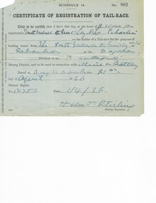
Document - MCCOLL, RANKIN AND STANISTREET COLLECTION: RENT RECEIPTS, 1930/40
... Evans 127 Breen Street Bendigo. 3. Plan for applied Lease 10423... Inc. History House 11 Mackenzie Street Bendigo goldfields ...1. Rent receipts, permissive occupancy, Monument Hill Consolidated. 2. Right to occupy a residence area, Victoria Phillipa Evans 127 Breen Street Bendigo. 3. Plan for applied Lease 10423. 5. Certificate of Registration of tail race. Loose documents.MCCOLL RANKIN & STANISTREETorganization, business, industrial - mining, mccoll rankin & stanistreet -
 Whitehorse Historical Society Inc.
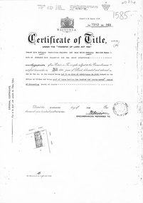
Document, Certificate of Title, 1/06/1951
... of Subdivision No 6626, 50 Burnett Street, Mitcham, with Plan..., being Lot 72 on Plan of Subdivision No 6626, 50 Burnett Street ...Certificate of Title Vol 7583 Fol 060, being Lot 72 on Plan of Subdivision No 6626, 50 Burnett Street, Mitcham, with Plan of Subdivision No 6626 including Burnett Street, Thomas Street, bordered by Cook Street and Cook Street and Whitehorse Road, Mitchamburnett street, mitcham, no 50, thomas street, cook road, whitehorse road -
 Ringwood and District Historical Society
Plan, Drill Hall Site - Design for Military Units and Miniature Rifle Range, Ringwood, Victoria - Circa 1935
... Site, Station Street, Ringwood. (b) Plan View, End and Side..., Station Street, Ringwood. (b) Plan View, End and Side Elevation ...Technical drawings (a) Block Plan - Ringwood Drill Hall Site, Station Street, Ringwood. (b) Plan View, End and Side Elevation, Drill Hall Wodonga - Removed to Ringwood. (c) Plan View, Front and Rear Elevations, Minature Rifle Range at Ringwood Drill Hall.Commonwealth of Australia. Department of The Interior, Works & Services Branch, Victoria. -
 Eltham District Historical Society Inc
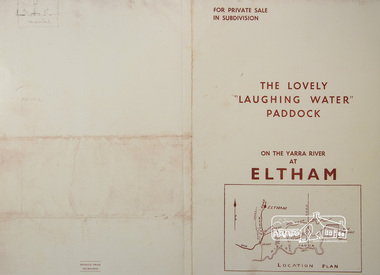
Photograph, For Private Sale in Subdivisions; The Lovely "Laughing Water" Paddock on the Yarra River at Eltham
... Collins Street, Melbourne Location plan and subdivision map... Collins Street, Melbourne Location plan and subdivision map ...Private sale of the "Laughing Water" paddock in subdivision; 5 river frontages with weatherboard villa on Lot 8; 6 woodland blocks of 5 and 6 acres. Sole Agent: Edward Haughton, 379 Collins Street, Melbourne Location plan and subdivision mapA3 colour photographic print from digital image of sales brochure and A4 reproduction of price listlaughing waters, edward haughton, real estate agent, eltham -
 Melbourne Tram Museum
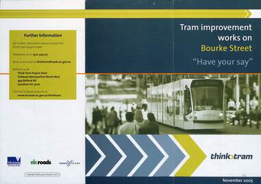
Pamphlet, VicRoads, "Tram stop improvements works on Bourke St", 2005 to 2007
... , Queen and Russell streets - with plans - Sept. 2007..., Queen and Russell streets - with plans - Sept. 2007 Yields ...Set of four Pamphlets - DL - full colour for installation of Bourke St super stops or platform stops in Bourke St. 1 - Have your say - 3 fold DL - Nov. 2005 2 - Have you say - 5 fold DL with a proposed plan - June 2006 3 - Construction - Spring and Spencer St - 3 fold DL - with plan - May 2007 4 - Constructon - William, Queen and Russell streets - with plans - Sept. 2007Yields information about the installation of super stops in Bourke St 2005 to 2007.Set of four Pamphlets - DL - full colour trams, tramways, super stops, platform stops, bourke st, planning, construction -
Port Melbourne Historical & Preservation Society
Document - Specification, Metalling and chanelling, Boundary Street South, Graham Street to St Vincents Street, Arthur Victor Heath, Town Clerk et al, 14 Mar 1893
... Specifications (Reg. 77.1) and plan (Reg 77.2... Engineering - Roads Streets Lanes and Footpaths Town Planning Town ...Specifications (Reg. 77.1) and plan (Reg 77.2) for metalling and channelling Boundary Street South [Pickles Street] from Graham Street to St. Vincents Street. Loan works 1893, plan No. 5.A.V. Heath (Town Surveyor):J.J. Bartlett (Mayor)engineering - roads streets lanes and footpaths, town planning, town clerks, mayors, arthur victor heath, james john bartlett -
Port Melbourne Historical & Preservation Society
Plan - Metalling and chanelling, Boundary Street South, Graham Street to St Vincents Street, 14 Mar 1893
... Specifications (Reg. 77.1) and plan (Reg 77.2... Engineering - Roads Streets Lanes and Footpaths Town Planning Town ...Specifications (Reg. 77.1) and plan (Reg 77.2) for metalling and channelling Boundary Street South [Pickles Street] from Graham Street to St. Vincents Street. Loan works 1893, plan No. 5.J.J. Bartlett (Mayor) 14/3/93engineering - roads streets lanes and footpaths, town planning, town clerks, mayors, arthur victor heath, james john bartlett -
 Greensborough Historical Society
Poster - Planning Document, City of Heidelberg, Subdivision Plan # G 27, Greensborough and Diamond Creek, 1922 and 1963
... , Parish of Keelbundoora: plan 1: Henry Street, Vermont Avenue..., Parish of Keelbundoora: plan 1: Henry Street, Vermont Avenue ...Plan of Subdivisions in City of Heidelberg: Side 1: 2 plans, Parish of Keelbundoora: plan 1: Henry Street, Vermont Avenue, Lyell Street, Nell Street, McDowell Street, 1922. Plan 2: Henry Street, Nepean Street, Charles Street, 1922. Side 2: 2 plans Parish of Nillumbik, Portion 13: Plan 1: Diamond Creek Road, Delfin Crescent, Ridge Road, 1963. Plan 2: Kinglake Road, Eltham Road, 1963.An example of hard copy subdivision plans from the Greensborough area. Mainly from the Shire of Diamond Valley era (1964-1994).Plan (2 sided) mounted on heavy card. Contains 2 sheets pasted together.Stamped and handwritten Council permissions, dates and other details.subdivision plans, city of heidelberg -
 Kew Historical Society Inc
Plan - Subdivision Plan, Shop Sites, East Kew, c.1927
... and Station Street. The plan shows this stretch of High Street, East... and household gardens. subdivision plans - east kew high street - east ...Subdivision plans are historically important documents used as evidence of the growth of suburbs in Australia. They frequently provide information about when the land was sold on which a built structure was subsequently constructed as well as evidence relating to surveyors and real estate and financial agents. The numerous subdivision plans in the Kew Historical Society's collection represent working documents, ranging from the initial sketches made in planning a subdivision to printed plans on which auctioneers or agents listed the prices for which individual lots were sold. In a number of cases, the reverse of a subdivision plan in the collection includes a photograph of a house that was also for sale by the agent. These photographs provide significant heritage information relating house design and decoration, fencing and household gardens.This is one of a small number of subdivision plans for commercial property in the collection. The subdivision proposed to create six shop sites in High Street between the Harp of Erin and Station Street. The plan shows this stretch of High Street, East Kew already lined with shops that include the hotel on the corner, the new State Savings Bank, a dentist’s surgery and Lambert’s Store. The High Street Tram was to reach Burke Road in 1925, so the proposed subdivision must postdate that event, and the opening of the Bank in 1926.subdivision plans - east kew, high street - east kew -
 Kew Historical Society Inc
Plan, Survey Plan, Park Hill Road, Kew, 1880-1890
... by Payne in Park Hill Road, Kew. The plan includes street names... The streets identified on the survey plan - Cotham Road, Park Hill ...The streets identified on the survey plan - Cotham Road, Park Hill Road East, Park Hill Road West in Kew were each gazetted by the Victorian Government in 1865. The hand-coloured survey plan was completed by Holland Loxton, Town Clerk and Surveyor of the Borough of Kew from 1866. The unnamed survey plan includes names of land owners in addition to measurements (2 chains to 1 inch) and streets. Named owners include Webster, Payne and Francom which will enable us to narrow down the creation date of the survey.Handdrawn survey plan by a former surveyor and town clerk of KewHand drawn and coloured survey plan created by Holland Loxton, Surveyor and Town Clerk of Kew, showing land owned by Payne in Park Hill Road, Kew. The plan includes street names, land measurements and land owners.surveys - kew, maps - kew, holland loxton, park hill road - kew, holland loxton -- surveyor, survey plans -- parkhill road -- kew (vic.) -
 Ringwood and District Historical Society
Map, Proposed Subdivision - Hilltop Estate, Heathmont, Victoria - circa 1925
... Plan of Part of Crown Allotments 16 & 18, Parish..., 440 Little Collins Street, Melbourne. Plan of Part of Crown ...Plan of Part of Crown Allotments 16 & 18, Parish of Ringwood, County of Mornington. Subdivision includes Site for Heathmont Station, Heathmont Road, George Street, Lilian Street, Edith Street, Edna Street, Great Ryrie Street. Inset locality plan also shows nearby Electric Railway Estate and Heathmont Station Estate. L.H. Webber, Licensed Surveyor, 440 Little Collins Street, Melbourne. -
 Bendigo Historical Society Inc.
Document - MCCOLL, RANKIN AND STANISTREET COLLECTION: SOUTH DEBORAH GOLD MINES NL GOLD LEASE DOCUMENT, 14/1/1941
... , Fol. 35893. Lease adjoins Railway Reserve, Breen Street... Inc. History House 11 Mackenzie Street Bendigo goldfields ...Document: McColl, Rankin and Stanistreet - South Deborah Gold Mines NL. Gold mining lease document. No. 11141, Vol. 325, Fol. 35893. Lease adjoins Railway Reserve, Breen Street. Attached to plan with pin piece of paper, written in pencil ' application Atherton 14/4/46 - consent refused - hand drawn map with Honeybone Street.organization, mining, south deborah gold mines nl, mccoll, rankin and stanistreet, south deborah gold mines nl, gold mining lease documents -
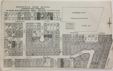 Kew Historical Society Inc
Plan - Subdivision Plan, Churchill Park Estate, Templestowe
... Estate inTemplestowe. Streets identified in the plan include... Estate inTemplestowe. Streets identified in the plan include ...Historic subdivision plan of the Churchill Park Estate in Templestowe.Undated subdivision plan advertising the Churchill Park Estate inTemplestowe. Streets identified in the plan include: Corroboree Place, Astley Street, Jeffrey Street, Airds Road, Dove Court, Potter Court, Thompsons Road, Richards Street, and Birchwood Avenue.Annotations in ink on the plan by agentsubdivision plans - templestowe (vic), churchill park estate - templestowe (vic) -
 Kew Historical Society Inc
Plan - Subdivision Plan, Boulevard Estate - Boulevard Section, 1930-1936
... . These street names, at least in this subdivision plan linked the two.... These street names, at least in this subdivision plan linked the two ...Pru Sanderson, in her groundbreaking ‘City of Kew Urban Conservation Study : Volume 2 - Development History’ (1988), summarised the periods of urban development and subdivisions of land in Kew. The periods that she identified included 1845-1880, 1880-1893, 1893-1921, 1921-1933, 1933-1943, and Post-War Development. These periods were selected as they represented periods of rapid growth or decline in urban development. An obvious starting point for Sanderson’s groupings involved population growth and the associated economic cycles. These cycles also highlighted urban expansion onto land that was predominantly rural, although in other cases it represented the decline and breakup of large estates. A number of the plans in the Kew Historical Society’s collection can also be found in other collections, such as those of the State Library of Victoria and the Boroondara Library Service. A number are however unique to the collection.The Kew Historical Society collection includes almost 100 subdivision plans pertaining to suburbs of the City of Melbourne. Most of these are of Kew, Kew East or Studley Park, although a smaller number are plans of Camberwell, Deepdene, Balwyn and Hawthorn. It is believed that the majority of the plans were gifted to the Society by persons connected with the real estate firm - J. R. Mathers and McMillan, 136 Cotham Road, Kew. The Plans in the collection are rarely in pristine form, being working plans on which the agent would write notes and record lots sold and the prices of these. The subdivision plans are historically significant examples of the growth of urban Melbourne from the beginning of the 20th Century up until the 1980s. A number of the plans are double-sided and often include a photograph on the reverse. This plan shows a subdivision with two sections: the ‘Boulevard Section’ and the ‘Riverside Section’. The first of these sections bordered Burke Road between Kilby Road and the farm beside the Yarra. Kilby Road, Munro Road, Burke Road and Old Burke Road bordered the 102 lots in the Boulevard Section of the plan. The streets within the Section included Walbundry Avenue, Inverness Way, Riverside Avenue, Cascade Street and Kyora Parade. These street names, at least in this subdivision plan linked the two Sections of the subdivision. At a later date, the City of Kew decided to alter the street names. Walbundry, Inverness, Riverside, Cascade and Kyora were all renamed as ‘Drives’ (e.g. Kyora Drive). The subdivision plan is of interest in that it names High Street in Kew as Doncaster Road. It also shows the location of the wooden church that was later removed to Yarraville on the corner of Kilby Road and High Street. The plan predates later developments such as the S. E. Dickens Supermarket.subdivision plans - east kew, boulevard estate, munro road -- kew east (vic.), kilby road -- kew east (vic.), burke road -- kew east (vic.), walbundry avenue -- kew east (vic.), inverness way -- kew east (vic.), riverside avenue -- kew east (vic.), cascade drive -- kew east (vic.), nyora parade -- kew east (vic.) -
 Federation University Historical Collection
Plan, Ballaarat City Parish Plans, 1931, 09/03/1931
... Large Scale plans showing streets, allotments, dimensions... Street, Hickman Street Ballaarat City Parish Plans, 1931 Plan ...Large Scale plans showing streets, allotments, dimensions, crown grantees, dates granted, etc Sheet 2: Sturt Street, Rubicon Street, Pryor Street, Humffray Street, Sebastopol Street, Armstrong Street South, Fraser Street, Hickman Street ballarat, ballaarat, plans, city of ballarat -
 Tatura Irrigation & Wartime Camps Museum
Booklet, Streetscape, 1998
... of the building from Wyndham Street and ground floor plan on back cover..., view of the building from Wyndham Street and ground floor plan ...Printed in 1998 as a record of the exhibition held at Shepparton Art Gallery, July, 1998. Booklet deals with early architecture in Shepparton Region, includes maps, plans, photographic images and catalogue of 100 years of progress. Soft cardboard, light grey background with Shepparton Post Office fascade and first floor plan on front cover, view of the building from Wyndham Street and ground floor plan on back cover. The word "streetscape" printed across front seven times. early buildings, shepparton art gallery exhibitions, shepparton architecture, shepparton photographic images -
Kew Historical Society Inc
Archive (Sub-series) - Lyons, Dorothy File, Kew Historical Society, 'Ivy Grange', 1-3 Malmsbury Street, 1970
... to alter the portico facing Malmsbury Street, Kew. These plans... to alter the portico facing Malmsbury Street, Kew. These plans ...Various partiesReference, Research, InformationSecondary Values (KHS Imposed Order)Subject file containing brief notes on the history of the Ivy Grange compiled from various sources plus correspondence and planning documents relating to plans submitted to the City of Kew to alter the portico facing Malmsbury Street, Kew. These plans predated the first Kew Urban Conservation Study (Sanderson, 1988). There is also one newspaper article relating to the sale of the house in 2005.kew historical society - archives, kew - history, ivy grange - 1-3 malmsbury street - kew (vic), mansions - kew (vic), david beath (1835-1922), architects - victoria - charles vickerskew historical society - archives, kew - history, ivy grange - 1-3 malmsbury street - kew (vic), mansions - kew (vic), david beath (1835-1922), architects - victoria - charles vickers -
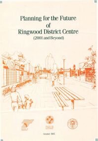 Ringwood and District Historical Society
Pamphlet, Planning for the Future of Ringwood District Centre 2001 and Beyond - October 1987
... , Possible Station Street Upgrading. Planning consultants - Wolinski... consultants' report outlining Ringwood's central structure plan ...A4 size 6-page multi-fold consultants' report outlining Ringwood's central structure plan for the new millennium. Topics: Traffic Circulation and Parking, Regional Retailing Focus, Entertainment Precinct, Office Precinct, Railway Precinct, Residential Conservation Zones, Retail Specialty Core, Commercial Boulevard, Possible Station Street Upgrading. Planning consultants - Wolinski Planners Pty. Ltd., were commissioned by Ministry for Planning and Environment, City of Ringwood and the Ministry of Transport in 1986 to prepare and exhibit the plan for public comment. After consideration of responses, the Working Group will make recommendations to the Council and Ministers subject to hearings of any formal submissions. -
Glen Eira Historical Society
Document - Murrumbeena State School No. 3449
... Street maps of area, Plans for proposed new structure... facility. Contains Street maps of area, Plans for proposed new ...Submission to Caulfield Council for the construction of a Community Education Facility/Multi- Purpose Room for Murrumbeena State School Prepared for submission April, 1981, Rationale for costing of Community Education/ Multi- Purpose facility. Contains Street maps of area, Plans for proposed new structuremurrumbeena state school, hobart road murrumbeena, school, caulfield city council, school council, howard and munro architects., community education, facility, site plans, murrumbeena primary school council, education department.