Showing 9430 items
matching the boulevard
-
 Port Melbourne Historical & Preservation Society
Letter - Elizabeth Cromb re photographs of Port Melbourne foreshore, Elizabeth Cromb, 1999
Sent by Betty Cromb, who lived at corner of The Boulevard and Barak Road, with photos she'd taken at the foreshoreNote that accompanied two colour photos Port Melbourne foreshore, taken and sent by Elizabeth Cromb, 1999natural environment, elizabeth cromb -
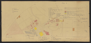 University of Melbourne, Burnley Campus Archives
Plan - Coloured plan, Thomas H. Kneen, School of Horticulture - Burnley, 1948-1949
Colour-coded to show existing and proposed buildings, numbered and lettered to indicate use of buildings Related documents: B91.476, B91.484Plan with handwritten amendments by T.H. Kneen on 24.10.1949. Extensive explanation of existing and proposed structures at the College. Plan A: area bounded by Swan St., Yarra Boulevard, reserves for grazing, orchard and vegetable gardens along southern boundary. Amended 24/10/49 T.H. Kneent.h. kneen, burnley gardens, burnley school of horticulture, farm buildings -
 Bendigo Historical Society Inc.
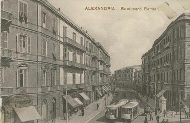
Postcard - BLANCHE SLY POSTCARD COLLECTION, 1900 - 1920
Postcard Album of Blanche Sly. Postcards stored in Folder 81 (49 postcards). 1403.1 - 1403.28 Grey linen look cover with picture of a small sailing boat pasted centre front pf cover. Partly torn sticker on lower LH corner. Blanche Victoria SLY Born: 11 Oct 1890, daughter of William and Hannah Sly Address: 1913; Loddon Vale Address: 1980; 100 Barnard Street Bendigo Died: Bendigo 12 June 1982, buried Bendigo G3 William Sly: Born: 1856 at Smythesdale, Victoria Married in Victoria in 1887; Hannah Theilman Died: Bendigo 1937, buried Bendigo G1 Hannah Sly Nee Theilman Born: 1866 Married in Victoria in 1887; William Sly Died: Bendigo 1948, buried Bendigo G3 See additional Research .Postcard Album of Blanche Sly containing 49 postcards. See 1403 B&W photo of the Boulevard Ramleh, Alexandria, Egypt. Curved street with 4 story buildings each side. 2 trams and pedestrians in foreground. Addressee - Blanche Sender - Will Hasty Dated 30/10/16postcard, collector, blanche sly -
 University of Melbourne, Burnley Campus Archives
Photograph - Colour print, Konica, Lagoon or Boulevard Paddock, Unknown
2 colour photographs. 1. Lagoon or Boulevard Paddock and Quad Classrooms from the other side of the Yarra River. 2.View towards the rock bank behind Swan Street from the other side of the Yarra River.lagoon paddock, boulevard paddock, quad classrooms, yarra river -
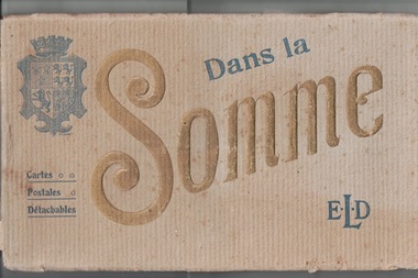 Lara RSL Sub Branch
Postcards Booklet, Picture Postcard Booklet. Dans La Somme....E L D....Cartes.....Postales......Detachables
This item presented to LARA R S L &is one of several Items issued to J W McINTYRE !st w w..HISTORIC......ARTISTICA n oblong (landscape)beige with age cardboard cover ......with approx . 20 postcards (each separated with tissue). Overall the colour is beige.AFrench publication .THEFront cover has a Coat of Arms showing Lions Rampart & aCrown. Manufacturer E.LE DELEY.127,boulevard de Sebastopol,PARIS . -
 Bendigo Historical Society Inc.
Newspaper - JENNY FOLEY COLLECTION: HERALD SUN
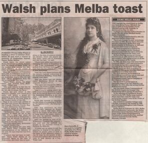
Sunday Herald Sun from December 17, 2000. Article by Jim Murphy on Mike Walsh plans to rename Exhibition Street, Melba Boulevard or Melba Avenue and erect a statue to honour Dame Nellie Melba. The clip is in a folder.newspaper, herald, article -
 Kew Historical Society Inc
Photograph - Aerial Photograph, Aerial Photograph of Willsmere, circa 1980, c. 1980
This aerial photograph shows the Kew Cottages, and doctors/clergy residences on the north side of Wills Street, before the State Government sold the land for residential development. The doctors residences in Wills street were made of 'Glen Iris' Olympic Bricks. According to neighbours of the time most of the buildings were demolished overnight in the 1980s.Aerial photograph of Willsmere and the Kew Cottages bounded by the Boulevard, the Chandler Highway, Princess Street and Fellows Street. The roundabout at the intersection of Princess Street, Wills Street, and Eglinton Street is at the top left. The Eastern Freeway is at the lower edge of the photograph.kew cottages, eastern freeway, willsmere, yarra river, aerial photographs -- kew (vic), kew boulevard, willsmere mental hospital, kew mental hospital, kew childrens cottages -
 Eltham District Historical Society Inc
Photograph, Jim Connor, Main Road, Eltham, 14 Jan 2017
Eltham Gateway, View of 43 Antoinette Boulevard from Main Road at the approaches of the Main Road Bridge over the Diamond CreekTomorrow's history documented todayeltham, jim connor collection, main road, eltham gateway -
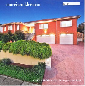 Greensborough Historical Society
Advertising Leaflet, 20 Sugar Gum Boulevard Greensborough, 05/09/2017
20 Sugar Gum Boulevard Greensborough. 4 bedroom house. October 2017 for $1,210,000. Previous sales: September 2005 for $325,000.Real Estate advertising leaflet,1 sheet folded into 4 pages, printed in colour both sides.sugar gum boulevard greensborough -
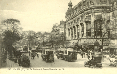 Federation University Historical Collection
Postcard - black and white, Paris - Le Boulevard Bonne-Nouvelle, c1910
This item most probably dates from the World War One era. Boulevard de Bonne Nouvelle in the 9th district of the city of Paris.Buses and cars travel along a Paris street lined with buildings.chatham-holmes family collection, paris, bus, car, horse, world war one, paris, france -
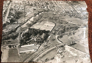 University of Melbourne, Burnley Campus Archives
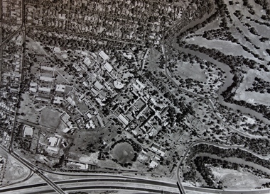
Photograph - Black and white print, Airspy, Aerial View of Burnley Campus c. 1930, c. 1930
Taken before the Boulevard was built, and probably before the flood of 1934. Therefore probably 1929-1934. Information provided by TH Kneen and EB LittlejohnColour photograph of black and white photograph. Photograph of Burnley Campus and large area of surrounding suburbs of Hawthorn and Toorak. It shows the Carter Oval, later modified, the Plant Research Institute (built 1929) and the Box Thorn Hedge (Lycium ferrocissimum).burnley campus, suburbs, hawthorn, toorak, carter oval, plant research institute, boxthorn hedge, lycium ferrocissimum -
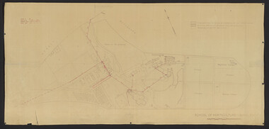 University of Melbourne, Burnley Campus Archives
Plan, School of Horticulture -Burnley, 1950
Same layout as plan at B91.0471, but showing PMG cables, and buildings existing, proposed and temporary or for demolitionPlan showing layout of PMG cables and PMG plant. Area bounded by Swan St., Yarra Boulevard, orchard, vegetable garden, market garden and S.W. Boundary to Stockman's Cottage. PMG layout handwritten. On same plan as B91.0484 (original) and B11.0383.burnley school of horticulture, orchard, gardens, vegetables, stockman's cottage -
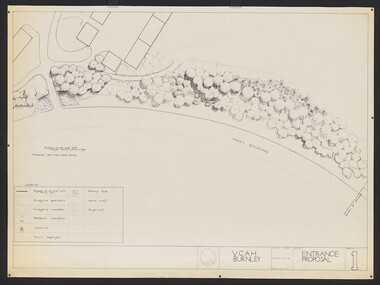 University of Melbourne, Burnley Campus Archives
Plan, Entrance Proposal, 1987-1988
Plans for Entrance from Yarra Boulevard. (1) Tracing paper and paper copies, Entrance Proposal Drawing No. 1. V.C.A.H. Burnley, Aug '87 by R.C., Planting Plan. (2) Tracing paper and paper copies V.C.A.H. Burnley 28.9.88 by JK.vcah, burnley, main entrance, jill kellow -
Vision Australia
Audio (item) - Sound recording, Royal Victorian Institute for the Blind, Around the Institute: March 22, 2005
Around the Institute was a weekly program consisting of interviews around a specific topic, undertaken by host Corey Nassau. March 22: Lighthouse on the Boulevard book launch.royal victorian institute for the blind, radio shows -
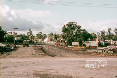
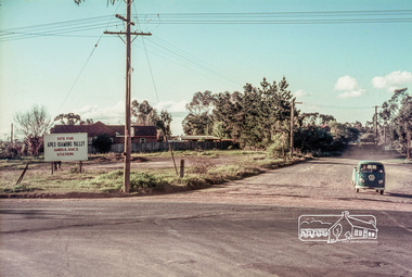 Eltham District Historical Society Inc
Slide, Site for the new Apex-Diamond Valley Ambulance Station, corner of Main Road and Grand Boulevard, Montmorency, July 1969, 1969
View looking west along Grand Boulevard from the intersection with Main Road and Panorama Avenue, Montmorency showing the site for the new Apex-Diamond Valley Ambulance Station and before construction of Apex Way, July 1969. The Eltham Apex Club conducted a Community Service Project (1965-1968) to raise funds for a new Ambulance Station to service the community. A site bounded by the intersection of Main Road, Grand Boulevard and Looker Road at Montmorency was purchased in 1969. In 1970, Eltham Shire Council undertook roadworks to construct Apex Way in preparation for the new station as well as duplicate Main Road, Lower Plenty, east of Grand Boulevard including the new Lower Plenty Bridge, which had been opened in November 1966, bordering with the City of Heidelberg.35 mm colour positive transparency Mount - Agfacolor Service (Blue)1969-07, ambulance station, apex way, grand boulevard, lower plenty, main road, montmorency, eltham ambulance station, apex-diamond valley ambulance station, eltham apex club -
 Eltham District Historical Society Inc
Slide, Looking southwest across to 184 Main Road, Lower Plenty during road widening works, 20 July 1970, 1970
Road works to widen and duplicate Main Road at Lower Plenty from top of hill near Grand Boulevard, Montmorency to shire border at Lower Plenty bridge35 mm colour positive transparency Mount - Agfacolor Service (Blue)duplication, lower plenty, main road, road construction -
 Eltham District Historical Society Inc
Slide, Looking east along Main Road, Lower Plenty near No. 184 during road widening works, 20 July 1970, 1970
Road works to widen and duplicate Main Road at Lower Plenty from top of hill near Grand Boulevard, Montmorency to shire border at Lower Plenty bridge35 mm colour positive transparency Mount - Agfacolor Service (Blue)duplication, lower plenty, main road, road construction -
 Eltham District Historical Society Inc
Slide, Looking southwest along Main Road, Lower Plenty near No. 169 during road widening works, 20 July 1970, 1970
Road works to widen and duplicate Main Road at Lower Plenty from top of hill near Grand Boulevard, Montmorency to shire border at Lower Plenty bridge35 mm colour positive transparency Mount - Agfacolor Service (Blue)duplication, lower plenty, main road, road construction -
 Eltham District Historical Society Inc
Slide, Looking southwest along Main Road, Lower Plenty near No. 167 during road widening works, 20 July 1970, 1970
Road works to widen and duplicate Main Road at Lower Plenty from top of hill near Grand Boulevard, Montmorency to shire border at Lower Plenty bridge35 mm colour positive transparency Mount - Agfacolor Service (Blue)duplication, lower plenty, main road, road construction -
 Eltham District Historical Society Inc
Slide, Looking northeast along Main Road, Lower Plenty near No. 122 during road widening works, 20 July 1970, 1970
Road works to widen and duplicate Main Road at Lower Plenty from top of hill near Grand Boulevard, Montmorency to shire border at Lower Plenty bridge35 mm colour positive transparency Mount - Agfacolor Service (Blue)duplication, lower plenty, main road, road construction -
University of Melbourne, Burnley Campus Archives
Plan, Yarra Boulevard, Burnley, 1979, c.1987
Miscellaneous collection of concept plans and printed plans relating to areas around Yarra Boulevard, Burnley. (1) 3 coloured concept plans on tracing paper. (2) 4 plans from the City of Richmond City Engineers Department Series Yarra 500/042.yarra boulevard, burnley, richmond, city engineers department -
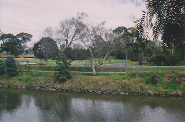
Port Melbourne Historical & Preservation Society
Photograph - Port Melbourne foreshore, Elizabeth Cromb, 1990s
Photographed by Betty CROMB, who lived at corner of The Boulevard and Barak Road, after wetlands had been created by the cleanup of the BP site. Before the building of Beacon Cove.One of two colour photos Port Melbourne foreshore, taken and sent by Elizabeth CROMB: Beacon Cove site pre-development. City skyline in background. View toward inland beacon and temporary wetlands soon to become Beacon Cove (The supplementray file is a letter from the donor)natural environment, beacons, town planning, built environment, piers and wharves - station pier, piers and wharves - princes pier, transport - ferries, elizabeth cromb, beacon cove -
Port Melbourne Historical & Preservation Society
Photograph - Port Melbourne foreshore, Elizabeth Cromb, c. 1992
Photographed by Betty Cromb, who lived at corner of The Boulevard and Barak Road; horses were often turned out here on their way to or from race meets on the Abel TasmanOne of two colour photos Port Melbourne foreshore, taken and sent by Elizabeth Cromb: Time when horses would come off the "Abel Tasman" from Tasmania from a race meeting.. Grazing on foreshore before returning home.natural environment, built environment, piers and wharves - station pier, livestock, transport - ferries, elizabeth cromb, horses -
 Port Melbourne Historical & Preservation Society
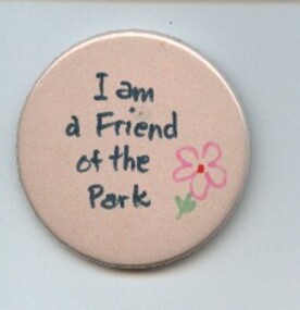
Badge - I am a friend of the park, Pat Grainger, 1987
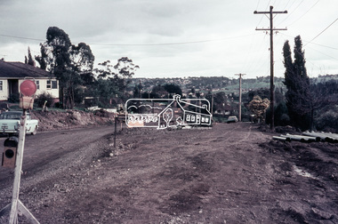
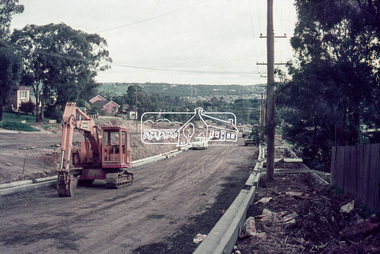
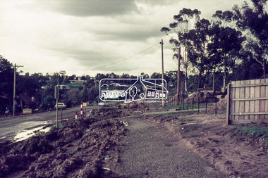
Used at a 1987 community picnic and the Port Melbourne Festival 1988 after Vic.Govt. announced plans to create a "Boulevard" along the Railway in order to provide an upmarket approach to the Bayside Development.Large, pale pink badge "I am a friend of the park" from 1987 protest group against establishment of a major road along the railway reserve."Badge - A - Minit" and logo impressed on backpublic action campaigns, town planning - proposals shelved, town planning - proposals shelved - bayside, friends of the park -
Port Melbourne Historical & Preservation Society
Photograph - Various reserves, Port Melbourne, Ron Laing, 1986 - 1999
Part of Ron Laing's collection of photographs recording Port Melbourne over a thirteen year period. Donated to the PMH&PS by the photographer.A set of 42 colour photographs of the various reserves including Garden City Reserve, West Gate Park and ibis, Boulevard and site from Webb Dock, new Evans Street gardens on the old railway sidings, and panorama looking east from Webb Dock. 1990sbuilt environment, natural environment, parks and gardens, ron laing -
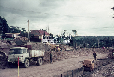
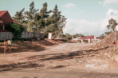
 Eltham District Historical Society Inc
Slide, Reconstruction of Grand Boulevard viewed from Panorama Avenue, Montmorency, 18 August 1970, 1970
The Eltham Apex Club conducted a Community Service Project (1965-1968) to raise funds for a new Ambulance Station to service the community. A site bounded by the intersection of Main Road, Grand Boulevard and Looker Road at Montmorency was purchased in 1969. In 1970, Eltham Shire Council undertook roadworks to construct Apex Way in preparation for the new station as well as duplicate Main Road, Lower Plenty, east of Grand Boulevard including the new Lower Plenty Bridge, which had been opened in November 1966, bordering with the City of Heidelberg.35 mm colour positive transparency Mount - Agfacolor Service (Blue)1970-08-18, apex-diamond valley ambulance station, eltham ambulance station, eltham apex club, grand boulevard, montmorency -
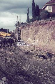
 Eltham District Historical Society Inc
Slide, Construction of Apex Way between Looker Road and Grand Boulevard, Montmorency, 18 August 1970, 1970
The Eltham Apex Club conducted a Community Service Project (1965-1968) to raise funds for a new Ambulance Station to service the community. A site bounded by the intersection of Main Road, Grand Boulevard and Looker Road at Montmorency was purchased in 1969. In 1970, Eltham Shire Council undertook roadworks to construct Apex Way in preparation for the new station as well as duplicate Main Road, Lower Plenty, east of Grand Boulevard including the new Lower Plenty Bridge, which had been opened in November 1966, bordering with the City of Heidelberg.35 mm colour positive transparency Mount - Agfacolor Service (Blue)1970-08-18, apex-diamond valley ambulance station, eltham ambulance station, eltham apex club, grand boulevard, looker road, montmorency -
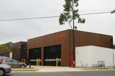 Greensborough Historical Society
Photograph - Digital Image, Marilyn Smith, Eltham Ambulance Branch from Grand Boulevard, 2018, 03/12/2018
Eltham Ambulance Branch, Apex Way Montmorency. The original ambulance station on this site was opened in 1975 and demolished in 2017. This photograph shows the new ambulance station, opened in 2018, from the front Grand Boulevard.Digital copy of colour photographeltham ambulance station, ambulance victoria, apex way montmorency, grand boulevard montmorency -
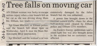 Eltham District Historical Society Inc
Document - Property Binder, 606 Main Road, Eltham
Newspaper article: Tree falls on moving car, Diamond Valley News, 15 April 1998, tree fell near Main Road and Antoinette Boulevard intersection, damaging car, power line and street light.main road, accident, eltham (vic)