Showing 15685 items
matching the valley
-
 Ringwood and District Historical Society
Newspaper, Yarra Valley Historical - A brief look at early life in the Yarra Valley during the mid 1800s to the 1900s (issued circa 2010)
... Yarra Valley Historical - A brief look at early life in the ...Early History of the Yarra Valley (Vol l Issue 2) Coldstream, Yering, Christmas Hills, Steels Creek, Gulf Station, Toolangi, Tarrawarra, Healesville, Fernshaw, The Black Spur, Narbethong, Marysville. -
 Glenelg Shire Council Cultural Collection
Container - Ceramic Jar, 1850s
Found on shipwreck of 'Nene Valley' by an abalone diver some 10 years ago. Nene Valley was built in Durham, Sunderland, in 1852 – a typical merchant vessel of the era built for the colonial trade. In June 1854 Nene Valley left Gravesend, England, on its final voyage carrying nine passengers and cargo. On 19 October, the vessel grounded 15km northwest of Cape Northumberland after the crew mistook the land ahead for a cloud on the horizon. When they realised their mistake it was too late for evasive action. All passengers and crew evacuated safely, but the following morning four crew drowned after they returned to the vessel to cut away the masts.Ceramic jar, hand made, cream base with straight sides, tan stain colour to neck, flat bottom. Wide mouth opening (55 mm) Nene ValleyNene Valleynene valley, shipwreck, container -
 Whitehorse Historical Society Inc.
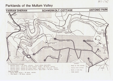
Pamphlet, Parklands of the Mullum Valley, 1998
... Parklands of the Mullum Valley ...recreation areas of the Mullum ValleyLeaflet of introduction to the parks and recreation areas of the Mullum Valley including a map of the area. recreation areas of the Mullum Valleyparks and reserves, yarran dheran, schwerkolt cottage, antonio park, mitcham, mullum mullum creek -
 Bendigo Historical Society Inc.
Newspaper - AILEEN AND JOHN ELLISON COLLECTION: THE LODDON VALLEY COURIER AND FARMERS' ADVOCATE
... AILEEN AND JOHN ELLISON COLLECTION: THE LODDON VALLEY ...A copy of "The Loddon Valley Courier and Farmers' Advocate" dated February 27, 1920. the paper has 4 pages and it was inside the book catalogue number 1572.127. on the back page there is an article that connect the paper to the book. The article is titled: Farewell to Mr. and Mrs. J. Waugh and family and it describe an evening at the Laanecoorie hall where the family was presented with gifts from the Laanercoorie for the standing in the community. Mr. John Waugh received a gold chain with an inscribed medal, Mrs. Waugh received a coffee service, miss Nora Waugh received a gold pendant and Tom Waugh a shaving outfit.newspaper -
 Kiewa Valley Historical Society
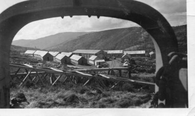
Photograph - Pretty Valley camp including workman's huts, Pretty Valley
At the Pretty Valley Dam site erection of staff quarters was completed in April, 1947 and accommodation for workmen commenced in 1948 but suspended on 11th May for winter and resumed on 9th November. Construction of this camp was completed in 1949. A large dam was proposed at this site but was never constructed. Instead a small diversion dam was built which diverts water either to Rocky Valley Dam or to McKay Creek Power Station.An historical record of the type of accommodation provided for workmen during the construction of the Kiewa Hydro Scheme during the 1940's/50'sBlack and white photograph of Pretty Valley camp showing workman's huts and construction materials.Handwritten on back of photograph in blue pen - Pretty Valleypretty valley, workmen's huts, victorian alps, secv -
Lakes Entrance Regional Historical Society (operating as Lakes Entrance History Centre & Museum)
Book, Gardner P D, Names of the Latrobe Valley and West Gippsland, 1992
... Names of the Latrobe Valley and West Gippsland ...Some of the place names of the Latrobe Valley and West Gippsland, victoria with explanations for their naming. Illustrated with map and photographs.township, historic sites, social history -
 Greensborough Historical Society
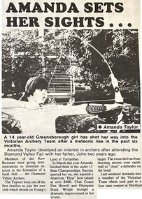
Newspaper - Newspaper Clipping - Digital Image, The Valley Voice, Amanda sets her sights, 24/10/1979
... The Valley Voice ...Amanda Taylor from Greensborough competed in a 4 state competition in archery (1979). Amanda and her family are members of the Diamond Valley Archers.Digital copy of newspaper articletaylor family, amanda taylor, diamond valley archers, archery -
 Marysville & District Historical Society
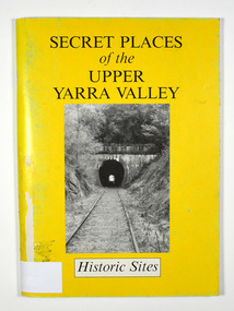
Book, Secret Places of the Upper Yarra Valley-Historic Sites, 1994
... Secret Places of the Upper Yarra Valley-Historic Sites ...A book describing historic sites in the Upper Yarra ValleyPaperback. Front cover has a black and white photograph of a railway tunnel at Healesville.A collection of places within the Upper Yarra/ Valley significant to the understanding of our/ heritage./ Aborigines, white explorers, pastoralists, gold/ miners and timber cutters have all left their mark./ These are sites which, despite modern/ development and urbanisation of our valley, are/ still able to give us an insight to an eventful past. Stamp of Marysville & District / Historical Society Inc / P.O. Box 22 / Marysville 3779upper yarra valley, history, historic sites -
 Harcourt Valley Heritage & Tourist Centre
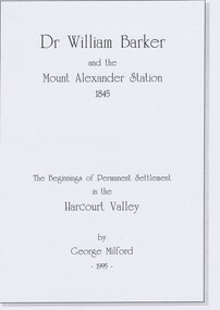
book, Dr. William Barker and the beginnings of permanent settlement in the Harcourt Valley 1845, 1995
... settlement in the Harcourt Valley 1845 ...Researched and Published for the 150th anniversary of permanent settlement celebrated in 1995Published to coincide with the 150th anniversary of the first permanent white settlement in the Harcourt valley.which was the occasion for community celebrations and of publication of a short history of squatting era pioneer Dr William Barker FRCS. Booklet of 8 pages in a hard cover“Dr Willam Barker and the beginnings of permanent settlement in the Harcourt Valley 1845” -
 Kiewa Valley Historical Society
Photograph - Tawonga Valley 1937, 06/05/1937
Hume and Hovell discovered the area in 1824 and by the end of the 19th century the valley was transformed by logging, dairy and beef cattle properties and tobacco farms. Historic photograph of the Tawonga Valley as it appeared in May 1937Black and white photograph of Tawonga Valley looking towards Mt BeautyHandwritten on rear of photograph in pencil - Thursday May 6th, 1937. Tawonga Valleytawonga, kiewa valley -
Tarnagulla History Archive
News clipping: Our Loddon Valley Aborigines - The Jajowrongs, Our Loddon Valley Aborigines - The Jajowrongs, June 23, 1981
... News clipping: Our Loddon Valley Aborigines - The...Our Loddon Valley Aborigines - The Jajowrongs ...Murray Comrie Collection. A double page article from The Advertiser (Maryborough) newspaper of June 23, 1981 with article about the Indigenous traditional owners of the region, the Djadjawurung and sites of cultural significance . central victoria, dja dja wurrung, djadjawurrung, indigenous australians, indigenous history, traditional owners, names, naming, maryborough area, bet bet creek, birthing tree talbot, rock wells -
 Kew Historical Society Inc
Photograph - Flooding of the Yarra Valley at Kew East, 1974
... Flooding of the Yarra Valley at Kew East ...Flooding of the Yarra Valley, including that section of the Yarra bordering Kew and Kew East in the north and west of the municipality, was a regular occurrence. Extreme flood events of the Yarra River are recorded to have occurred in 1891, 1901, 1916, 1923 and 1934. The Municipality of Kew's response to these floods was to enact planning decisions restricting residential development in flood prone areas following the floods of 1916, 1921 and 1934. While floods continued after the development of the Upper Yarra Reservoir (construction 1948-57), the regularity and extent of these inundations diminished. During the nineteenth century, the land abutting the south side of the Yarra in Kew was devoted to dairy farming. In the twentieth century, before and after the construction of the Eastern Freeway, much of this low-lying area was used as golf courses and public parks.Late example of the capacity of the Yarra Valley at Kew to flood, even though drainage works and the Upper Yarra Reservoir had reduced their regularity.Original black and white print photograph of the low-lying land at East Kew under floodwater on 16 May 1974. The vantage point of the photographer is Lister Street. In the photo, the fences of the Kilby Farm can be seen. Flooding was caused by overflowing water in Glass' Creek and the River Yarra. Annotation verso: "Hay's Paddock op No.30 Lister Street / 16 May 1974 11.50am / R.L. 46.04"hays paddock, floods, yarra river, glass' creek, lister street -
 Kew Historical Society Inc
Photograph - Flooding of the Yarra Valley at Kew East, 1974
... Flooding of the Yarra Valley at Kew East ...Flooding of the Yarra Valley, including that section of the Yarra bordering Kew and Kew East in the north and west of the municipality, was a regular occurrence. Extreme flood events of the Yarra River are recorded to have occurred in 1891, 1901, 1916, 1923 and 1934. The Municipality of Kew's response to these floods was to enact planning decisions restricting residential development in flood prone areas following the floods of 1916, 1921 and 1934. While floods continued after the development of the Upper Yarra Reservoir (construction 1948-57), the regularity and extent of these inundations diminished. During the nineteenth century, the land abutting the south side of the Yarra in Kew was devoted to dairy farming. In the twentieth century, before and after the construction of the Eastern Freeway, much of this low-lying area was used as golf courses and public parks.Late example of the capacity of the Yarra Valley at Kew to flood, even though drainage works and the Upper Yarra Reservoir had reduced their regularity.Original black and white print photograph of the low-lying land at East Kew under floodwater on 16 May 1974. The vantage point of the photographer is Lister Street. Flooding was caused by overflowing water in Glass' Creek and the River Yarra. Annotation verso: "Lister Street looking north / Flood level / 16 May 1974 11.30am / R.L. 46.04"hays paddock, floods, yarra river, glass' creek, lister street -
 Kew Historical Society Inc
Photograph - Flooding of the Yarra Valley at Kew East, 1974
... Flooding of the Yarra Valley at Kew East ...Flooding of the Yarra Valley, including that section of the Yarra bordering Kew and Kew East in the north and west of the municipality, was a regular occurrence. Extreme flood events of the Yarra River are recorded to have occurred in 1891, 1901, 1916, 1923 and 1934. The Municipality of Kew's response to these floods was to enact planning decisions restricting residential development in flood prone areas following the floods of 1916, 1921 and 1934. While floods continued after the development of the Upper Yarra Reservoir (construction 1948-57), the regularity and extent of these inundations diminished. During the nineteenth century, the land abutting the south side of the Yarra in Kew was devoted to dairy farming. In the twentieth century, before and after the construction of the Eastern Freeway, much of this low-lying area was used as golf courses and public parks.Late example of the capacity of the Yarra Valley at Kew to flood, even though drainage works and the Upper Yarra Reservoir had reduced their regularity.Original black and white print photograph of Hay's Paddock under floodwater on 16 May 1974. The vantage point of the photographer is Keystone Crescent looking east. Flooding was caused by overflowing water in Glass' Creek and the River Yarra. Annotation verso: "Keystone Cr looking east / 16 May 1974 11.50am"hays paddock, floods, yarra river, glass' creek -
 Kew Historical Society Inc
Photograph - Flooding of the Yarra Valley at Kew East, 1974
... Flooding of the Yarra Valley at Kew East ...Flooding of the Yarra Valley, including that section of the Yarra bordering Kew and Kew East in the north and west of the municipality, was a regular occurrence. Extreme flood events of the Yarra River are recorded to have occurred in 1891, 1901, 1916, 1923 and 1934. The Municipality of Kew's response to these floods was to enact planning decisions restricting residential development in flood prone areas following the floods of 1916, 1921 and 1934. While floods continued after the development of the Upper Yarra Reservoir (construction 1948-57), the regularity and extent of these inundations diminished. During the nineteenth century, the land abutting the south side of the Yarra in Kew was devoted to dairy farming. In the twentieth century, before and after the construction of the Eastern Freeway, much of this low-lying area was used as golf courses and public parks.Late example of the capacity of the Yarra Valley at Kew to flood, even though drainage works and the Upper Yarra Reservoir had reduced their regularity.Original black and white print photograph of the low-lying land at East Kew under floodwater on 16 May 1974. The vantage point of the photographer is Lister Street. Flooding was caused by overflowing water in Glass' Creek and the River Yarra. Annotation verso: "Lister St looking same as No.3 / 16 May 1974 11.30"floods, yarra river, glass' creek, lister street -
 Kew Historical Society Inc
Photograph - Flooding of the Yarra Valley at Kew East, 1974
... Flooding of the Yarra Valley at Kew East ...Flooding of the Yarra Valley, including that section of the Yarra bordering Kew and Kew East in the north and west of the municipality, was a regular occurrence. Extreme flood events of the Yarra River are recorded to have occurred in 1891, 1901, 1916, 1923 and 1934. The Municipality of Kew's response to these floods was to enact planning decisions restricting residential development in flood prone areas following the floods of 1916, 1921 and 1934. While floods continued after the development of the Upper Yarra Reservoir (construction 1948-57), the regularity and extent of these inundations diminished. During the nineteenth century, the land abutting the south side of the Yarra in Kew was devoted to dairy farming. In the twentieth century, before and after the construction of the Eastern Freeway, much of this low-lying area was used as golf courses and public parks.Late example of the capacity of the Yarra Valley at Kew to flood, even though drainage works and the Upper Yarra Reservoir had reduced their regularity.Original black and white print photograph of the low-lying land at East Kew under floodwater on 16 May 1974. The vantage point of the photographer is at Willsmere Road. The road itself is underwater.Annotation verso: "Willsmere Rd / Same as No.7 / 16 May 1974 11.15am"floods, yarra river, willsmere road -
 Kew Historical Society Inc
Photograph - Flooding of the Yarra Valley at Kew East, 1974
... Flooding of the Yarra Valley at Kew East ...Flooding of the Yarra Valley, including that section of the Yarra bordering Kew and Kew East in the north and west of the municipality, was a regular occurrence. Extreme flood events of the Yarra River are recorded to have occurred in 1891, 1901, 1916, 1923 and 1934. The Municipality of Kew's response to these floods was to enact planning decisions restricting residential development in flood prone areas following the floods of 1916, 1921 and 1934. While floods continued after the development of the Upper Yarra Reservoir (construction 1948-57), the regularity and extent of these inundations diminished. During the nineteenth century, the land abutting the south side of the Yarra in Kew was devoted to dairy farming. In the twentieth century, before and after the construction of the Eastern Freeway, much of this low-lying area was used as golf courses and public parks.Late example of the capacity of the Yarra Valley at Kew to flood, even though drainage works and the Upper Yarra Reservoir had reduced their regularity.Original black and white print photograph of the low-lying land at East Kew under floodwater on 16 May 1974. The photograph is of Hyde Park looking north-east.Annotation verso: "Hyde Park looking nth-east / Flood Level / 16 May 1974 11.15am / R.L. 46.61"floods, yarra river, hyde park -
 Kew Historical Society Inc
Photograph - Flooding of the Yarra Valley at Kew, 1974
... Flooding of the Yarra Valley at Kew ...Flooding of the Yarra Valley, including that section of the Yarra bordering Kew and Kew East in the north and west of the municipality, was a regular occurrence. Extreme flood events of the Yarra River are recorded to have occurred in 1891, 1901, 1916, 1923 and 1934. The Municipality of Kew's response to these floods was to enact planning decisions restricting residential development in flood prone areas following the floods of 1916, 1921 and 1934. While floods continued after the development of the Upper Yarra Reservoir (construction 1948-57), the regularity and extent of these inundations diminished. During the nineteenth century, the land abutting the south side of the Yarra in Kew was devoted to dairy farming. In the twentieth century, before and after the construction of the Eastern Freeway, much of this low-lying area was used as golf courses and public parks.Late example of the capacity of the Yarra Valley at Kew to flood, even though drainage works and the Upper Yarra Reservoir had reduced their regularity.Original black and white print photograph of the low-lying land at East Kew under floodwater on 16 May 1974. The photograph is taken from 43 Kellett Grove.Annotation verso: "Kellett Gve No.43 / Flood Level / 16 May 1974 11.40am"floods, yarra river, kellett grove -
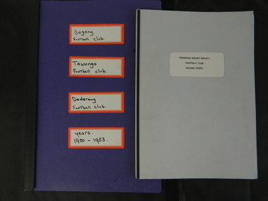 Kiewa Valley Historical Society
Paper Collection of Football Clubs of the Upper Kiewa Valley, 1940s onwards
... Paper Collection of Football Clubs of the Upper Kiewa ...Tawonga's first recorded game was against Yackandandah in 1893 at Tawonga. Tawonga folded up in 1957 enabling Bogong to have 2 teams, the firsts and seconds in 1958. Bogong merged with Dederang in 1976 and became the Dederang-Mt Beauty Football Club. Bogong joined the Yackandandah league in 1947. In 1954 Bogong entered the Ovens & King League. In 1960 Bogong United was in the Tallangatta League with Tallangatta, Kiewa, Kergunyah, Dederang, Lavington, Bandiana, Bullioh, Mitta United, Barnawartha, Sandy Creek and Yackandandah. The Kiewa league was formed in 1923. In the 1930's Tawonga was in the Chiltern League then the Dederang League, then the Yackandandah League and then the Tallangatta League.The papers are a primary source of the history of the Bogong, Tawonga, Dederang and Mt Beauty Football Clubs. They include family names of players and families living in the Kiewa Valley at the time and increase an understanding of the social changes country areas have undergone during the period covered.Paper records for local (Upper Kiewa Valley) football clubs' history including minute books, notes, journals, newspaper cuttings, footy records and booklet produced for the Dederang-Mt Beauty Golden Jubilee in 1998.football clubs; upper kiewa valley; sport -
 Eltham District Historical Society Inc
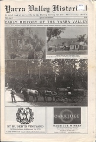
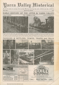
Work on paper (item) - Newspaper, Joseph Dubois, Yarra Valley Historical: a brief look at early life in the Valley during the mid 1800's to the 1900's
... Yarra Valley Historical: a brief look at early life in the ...Volume 1, Issue 1. Early History of the Upper and Yarra Valley. "Welcome to the fist edition of the Yarra Valley historical, the aim of this newspaper is to remind us of the men and women who came here to mine, farm or harvest the plentiful and tall timbers, that built towns and cities..." Estimated date of publication 2010. The newspaper is full of potted histories of places with historical photographs, maps and timelines. Acknowledgment and citations for source material given. Advertisements for business's at the time of publicaion. Lilydale, De Castella family, p2. Mount Evelyn p6. Wandin [Anker family] p7. Seville [William Henry Smith; Mr and Mrs Thomas Payne; Duck family; Chandler family] p8. Woori Yallock p10. Yellingbo p11. Hoddles Creek p12. Launching Place p13. Yarra Junction p14. Reminiscences of Don 'Ripper' Reid p18. Wesburn p20. Warburton Village Settlement p22. Warburton p23. Big Pats Creek p26. McMahons Creek / Reefton [Brimbonga School] p27. Gladysdale / Gilderoy [Saxton family] p28. Powelltown p30.lilydale, mt evelyn, wandin, seville, woori yallock, yellingbo, hoddles creek, launching place, yarra junction, don reid, reminiscences, wesburn, warburton, big pats creek, mcmahons creek, reefton, gladysdale, gilderoy, powelltown, newspaper -
 Kiewa Valley Historical Society
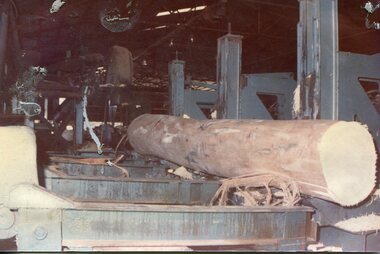
Photographs - 2 Colour photographs of logs being harvested and milled for timber in the Kiewa Valley
... and milled for timber in the Kiewa Valley ...: Hume and Hovell discovered the area in 1824 and by the end of the 19th century the Kiewa Valley was transformed by logging, dairy and beef cattle properties and tobacco farms. The logs could have been milled for timber at the State Electricity Commission's mill at Howman's Gap which provided a much needed source of timber for construction of McKay Creek Power Station which began construction in 1951 and also the camps and houses for the workers and their families There was a need for housing and infrastructure for an increasing population of workers for the hydro-electric scheme as there was a general shortage of this commodity. A timber mill was started in Tawonga by Mates, of Albury, in 1945, and electricity became available in 1946 the S.E.C. bought the mill, and enlarged it. In 1960 it was purchase by a local family, they also started a timber mill in Mt Beauty worked both until 1980 when they closed the Tawonga mill and enlarged the mill called Mt. Beauty Timbers Pty Ltd which employed approximately 50 people. An historical pictorial record of the type of machinery and vehicles in use in the 1950’s to harvest and mill the logs from surrounding forested areas.1. Colour photograph of large logs being milled for timber at a timber mill 2. Colour photograph of heavy machinery being used to harvest large logs for milling timber; timber mill; kiewa valley; forests; logging -
 Bendigo Historical Society Inc.
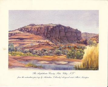
Document - BASIL MILLER COLLECTION: PRINT - 'THE AMPHITHEATRE COUNTRY PALM VALLEY NT, ALBERT NAMATJIRA
... BASIL MILLER COLLECTION: PRINT - 'THE AMPHITHEATRE COUNTRY ...Colour print of 'The Amphitheatre country, Palm Valley, NY. From the watercolour by Albert Namatjira.person, individual, basil miller -
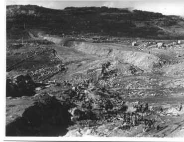 Kiewa Valley Historical Society
Photograph of Rocky Valley, Rocky Valley showing Dam Excavation, c1948-1951
This photograph was taken during construction of the Rocky Valley Dam and wall. Work was commenced in early 1947 but had to be suspended during winter and then resumed in October. Work continued in 1948 with the establishment of work facilities and, at the dam site, the river was diverted through a temporary pipeline. Rocky Valley and associated spillway and outlet works were completed in 1959.A pictorial record of the construction of the rock and earth filled dam wall at Rocky Valley. Shows the extent of the project undertaken and the fact that a lot of the work was done manually by pick and shovel - note the workmen using picks and sledge hammers on the lower half of the photo.A black and white photograph showing the excavation of the dam at Rocky Valley looking towards Heathey's SpurHand written on the back of photograph in blue ink "Rocky Valley showing dam excavation" rocky valley, dam, wall, picks, sledge hammers -
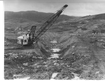 Kiewa Valley Historical Society
Photograph Rocky Valley Dam Excavations, Rocky Valley Dam Wall Excavation, c1947-48
Work commenced at Rocky Valley Dam site in early 1947 and proceeded until May. Resumed work in October after the winter and a camp for the accommodation of workmen was commenced at this time. Work continued in 1948 with the establishment of work facilities, including the erection of two large excavators. At the dam site the river was diverted through a temporary pipeline. Work proceeded in the summer months with the placing of concrete in the foundations and earth and rock fill for the construction of the wall. Rocky Valley and associated spillway and outlet works were completed in March, 1959. A very good representation of the type of machinery available in the 1940's used for excavation of the dam and the construction of the dam wall.Black and white photograph of Rocky Valley Dam wall under construction. There are at least three cranes plus workmen in the photo. This is taken from the Heathey's Spur side of the dam wall looking back toward Sun Valley.Hand written on back of photograph "Rocky Valley Dam Wall Excavation" in blue ink.rocky valley, dam, wall, machinery -
 Kiewa Valley Historical Society
7 small black and white photographs of Pretty Valley, c1948
In 1947 it was proposed to construct a dam on the Pretty Valley branch of the East Kiewa River. This was part of the initial planning in 1937. The Pretty Valley Reservoir was to be part of a pumped-storage scheme with a pumping station located immediately below the main structure. Preparatory work was commenced in 1946 with erection of staff accommodation. Between 1947 and 1950 the main camp was erected, access roads, constructed and banks and benches at the dam site undertaken. Following the financial crisis in 1951, a review of the scheme was carried out and work ceased in June 1951. Construction of the dam was deleted from the programme of works and all buildings removed.A pictorial history of part of the initial planning in 1937 for a dam to be constructed at Pretty Valley as part of the Kiewa Hydro Electric Scheme.7 small black and white photographs of Pretty ValleyAll photos have a circular stamp on the back with 'Print by Willson White Albury' enclosed. Photo 1 - on the back, handwritten in ink 'New 22Kv pump line - Pretty Valley Nov. 1948'. In pencil '18'. Photo 2 - On the back, handwritten in ink 'Pretty Valley - Staff mess on right Nov. 1948'. In pencil '18'. Photo 3 - On the back, handwritten in ink 'Pretty Valley Basin - looking S.E. Nov. 1948'. In pencil '5'. Photo 4 - On the back, handwritten in ink 'New pump 22Kv line, Pretty Valley - looking towards Mt. Mackie. Nov. 1948'. In pencil '5'. Photo 5 - On the back, handwritten in ink 'Pretty Valley. Mt. Cope just out of picture extreme right. Nov. 1948'. In pencil '78'. Photo 6 - on the back, handwritten in ink 'View from Pretty Valley Ruined Castle in Background Nov. 1948'. In pencil '78'. Photo 7 - on the back, handwritten in ink 'Pretty Valley Pump line (Nov. 1948)'. In pencil'78'.construct, dam, pretty valley -
 Marysville & District Historical Society
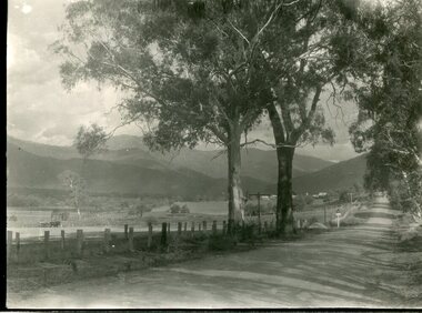
Photograph (item) - Black and white photograph, 10-1947
An early black and white photograph taken in the Cumberland Valley near Marysville in Victoria.An early black and white photograph taken in the Cumberland Valley near Marysville in Victoria. The Cumberland Valley is near Cambarville which was a timber town near Marysville. Cambarville is notable for its giant mountain ash (Eucalyptus regnans) trees within the Cumberland Memorial Scenic Reserve, and relics from former sawmills and gold mining. The Big Culvert is located nearby on the Marysville - Woods Point Road, which was historically part of the Yarra Track. Cambarville was established as a timber mill town in the 1940s. Timber mill owners A Cameron and FJ Barton named Cambarville. They established the mill to salvage timber from trees destroyed in the 1939 bushfires. Cambarville was impacted by the 2009 Black Saturday bushfires and any remaining structures were destroyed.Among Tall Timber at/ Cumberland Valley. Oct.47. 39cumberland valley, marysville, victoria, cumberland creek, mountain ash, timber mill, mining, a cameron, fj barton, cambarville, big culvert, yarra track, black saturday bushfires, 1939 bushfires, photograph -
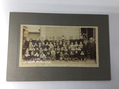 Chiltern Athenaeum Trust
Photograph - Photograph - Chiltern Valley School Children 1907, circa 1907
A school photo of the students from the Chiltern Valley School in 1907. The photograph is sourced from the Jack Lang Collection. school photo of the children from the Chiltern Valley school in 1907. Sepia photograph of Chiltern Valley school children 1907. Markings on reverse. Teacher known as “Bawly” Burke. 1st School Chiltern Valley. From Jack Lang collection. ( Barr Ch???? 20 07)1907 chiltern valley school photo, chiltern valley school 1907 -
 Eltham District Historical Society Inc
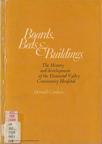
Book, Boards Beds and Buildings: The history and development of the Diamond Valley Community Hospital Greensborough; a community project / Donald Cordner
... the Diamond Valley Community Hospital Greensborough; a ...CONTENTS FOREWORD By Sir Henry Bolte ACKNOWLEDGEMENTS Chapter 1 - The Beginning Chapter 2 - The James Charitable Trust Chapter 3 - The Forming of a Corporation Chapter 4 - Preparation Chapter 5 - The Opening Chapter 6 - The Early Years 1942 - 1950 Chapter 7 - The New Hospital 1950 - 1956 Chapter 8 - Expansion 1956 - 1966 Chapter 9 - Completion 1966 - 1971 Chapter 10 - The Staff Chapter 11 - The Board Chapter 12 - The Medical Profession Chapter 13 - Amenities and Equipment Chapter 14 - The Auxiliaries and Other Contributors Chapter 15 - Patients and Their Treatment Chapter 16 - The Future Appendix I - Board Members 1942- 1971 Appendix II - Hospital Staff 30th June 1971 Appendix III - Office Bearers Of Auxiliaries Digital file only (71 pages and covers) Physical copy held by Yarra plenty Regional Library, Diamond Valley Branch, Civic Drive, Greensborough, Local History Sectiondiamond valley community hospital, greensborough -
 Greensborough Historical Society
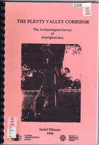
Book, Victoria Archaeological Survey, The Plenty Valley Corridor: the archaeological survey of Aboriginal sites / by Isabel Ellender 1989, 1989_
... The Plenty Valley Corridor: the archaeological survey of ...This archaeological survey of th Plenty Valley was conducted by Isabel Ellender in 1989 for the Ministry of Planning and Environment. The area studied is north of Greensborough to Whittlesea. A number of Aboriginal sites were identified and recommendations made for the future.103 p., illus., maps. Plastic spiral binding.plenty river, aboriginal heritage sites -
 Kiewa Valley Historical Society
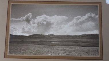
Photo - Pretty Valley, Bogong High Plains
Pretty Valley, Bogong High Plains is part of the Kiewa Hydro Electric SchemeBogong High Plains prior to the construction of the Kiewa Hydro Electric SchemeLarge rectangular sepia photo mounted on thick cardboard which has a printed frame around the photo. The photo is of Pretty Valley prior to the construction of the dam.On the back: 'Pretty Valley, Bogong High Plains'; Also: 'No 20' and '2389'pretty valley, pretty valley bogong high plains