Showing 223 items matching "topographical"
-
 Bendigo Military Museum
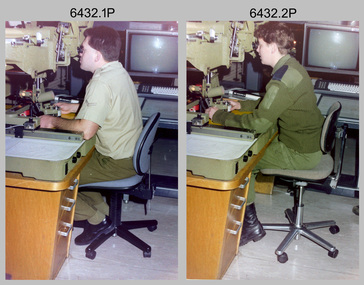
Photograph - Capturing Topographic Features with a Wild B8, AUTOMAP 2 Systems Operations – Army Survey Regiment, Fortuna, Bendigo, 1990
... This is a set of two photographs of Air Survey Squadron technicians - LCPL Peter Murphy and SPR Rachel (Stanford) Scott capturing topographic features with a Wild B8 stereo plotter with AUTOMAP 2 equipment at the Army Survey Regiment, Fortuna, Bendigo, c1990. ...This is a set of two photographs of Air Survey Squadron technicians capturing topographic features with a Wild B8 stereo plotter with AUTOMAP 2 equipment at the Army Survey Regiment at Fortuna, Bendigo, c1990. ...SPR Rachel (Stanford) Scott operating a Wild B8 stereo plotter. Capturing Topographic Features with a Wild B8, AUTOMAP 2 Systems Operations – Army Survey Regiment, Fortuna, Bendigo Photograph Capturing Topographic Features with a Wild B8, AUTOMAP 2 Systems Operations – Army Survey Regiment, Fortuna, Bendigo Army Survey Regiment ...This is a set of two photographs of Air Survey Squadron technicians - LCPL Peter Murphy and SPR Rachel (Stanford) Scott capturing topographic features with a Wild B8 stereo plotter with AUTOMAP 2 equipment at the Army Survey Regiment, Fortuna, Bendigo, c1990. Refer to item 6185.4P and 6204.8P for detailed information and additional photographs of the Wild B8 stereo plotter. The history of the AUTOMAP 2 system is covered in more detail with additional historic photographs in pages 119, 137-142 and 180 of Valerie Lovejoy’s book 'Mapmakers of Fortuna – A history of the Army Survey Regiment’ ISBN 0-646-4: 2120-4. See items 6087.10P and 6223.23P for additional photographs of the AUTOMAP 2 system.This is a set of two photographs of Air Survey Squadron technicians capturing topographic features with a Wild B8 stereo plotter with AUTOMAP 2 equipment at the Army Survey Regiment at Fortuna, Bendigo, c1990. The photographs are on 35mm negative film. They are part of the Army Survey Regiment’s Collection. The photographic negatives were scanned at 96 dpi. .1) - Photo, colour, 1990. LCPL Peter Murphy operating a Wild B8 stereo plotter. .2) - Photo, colour, 1990. SPR Rachel (Stanford) Scott operating a Wild B8 stereo plotter..1P to .2P – no annotationsroyal australian survey corps, rasvy, army survey regiment, army svy regt, fortuna, asr, photogrammetry -
 Bendigo Military Museum
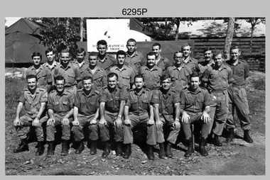
Photograph - A Section, 1st Topographic Survey Troop, Nui Dat, Vietnam, 1969
... This is a photograph of A Section, 1st Topographic Survey Troop taken at Nui Dat, Vietnam in 1969. ...This is a photograph of A Section, 1st Topographic Survey Troop taken at Nui Dat, Vietnam in 1969. ...Bendigo Military Museum 37 - 39 Pall Mall Bendigo goldfields This is a photograph of A Section, 1st Topographic Survey Troop taken at Nui Dat, Vietnam in 1969. ...This is a photograph of A Section, 1st Topographic Survey Troop taken at Nui Dat, Vietnam in 1969. A nominal roll of personnel and their trade as of the 30th of September 1969, accompanies this photo. Their trades in this photo were as follows - Surveyors Topographic: WO1 Darby Munro, SGT Paddy Strunks, SGT Graeme Birrell, CPL Brian Knight, CPL Colin Laybutt, SPR Roderick Gilbert and SPR Rodney Offer. Draughtsmen Topographic: SGT Terrance Linz, CPL Robert Kay, SPR Peter Aukstinaitis, SPR Lloyd Patterson and SPR Ian Wark. Photographer Cartographic: CPL George Graham. Clerk Admin: CPL Oreste Biziak. Helioworker: CPL Geoffrey White, SPR Lance Percey. Cook AACC: PTE R. Johnston. The first Royal Australian Survey Corps troops arrived in South Vietnam on the 10th of June 1966. This was a detachment from 1st Topographic Survey Troop, which was to give cartographic support to the Australian Task Force. Their main tasks were to establish a Theatre Grid, map compilation and map revision. Engineer Survey Support in the camp and to the civil community and give assistance to the Cordon Search Missions by producing large scale plots from aerial photos with every house and fence etc plotted and then reproduce these by silk screening usually, within a 24-hour period. This support concluded with the withdrawal of Australian troops from Vietnam in 1972. For more information on the career of A Section’s OC MAJ Peter Constantine AM, refer to item 6159P or 6092P. He was the CO of the Army Survey Regiment from 1975 to 1976 and CO of the School of Military Survey (SMS) from 1976 to his retirement in January 1982. His memoirs of active duty in Vietnam ‘Surveyor - Printer Behind the Lines’ was published in 2022. 2IC CAPT Frank Thorogood SB St J’s career culminated at the rank of LTCOL as the CO Army Survey Regiment from 1980 to 1981. More information on the A Section, 1st Topographic Survey Troop and the Army Survey Regiment’s supporting role is provided in pages 89 to 94 of Valerie Lovejoy’s book 'Mapmakers of Fortuna – A history of the Army Survey Regiment’ ISBN: 0-646-42120-4.This is a photograph of A Section, 1st Topographic Survey Troop taken at Nui Dat, Vietnam in 1969. The black and white photograph was printed on photographic paper and is part of the Army Survey Regiment’s Collection. The photograph was scanned at 300 dpi. .1) - Photo, black & white, 1969. Back row L to R: SPR Lance Percey, SPR Bruce Grisdale, SPR Rodney Offer, SPR Roderick Gilbert, CPL Geoffrey White, PTE R. Johnston, CPL Colin Laybutt, SPR Lloyd Patterson. Centre row L to R: SPR Peter Aukstinaitis, SPR Ian Hanna, SPR Ian Wark, CPL Robert Kay, CPL George Graham, CPL Oreste Biziak, CPL Brian Knight. Front row L to R: SGT Terrance Linz, SSGT Gordon Haswell, 2IC CAPT Frank Thorogood SB St J, OC MAJ Peter Constantine AM, WO1 Darby Munro, SGT Paddy Strunks, SGT Graeme Birrell.An A4 nominal roll of personnel and their trade accompanies the photo, as of the 30th of September 1969. A torn paper identifies the personnel in the photo. Annotated on back of photo – ‘Unit Photo – 1 Topo Svy Tp 30 Sept 69’royal australian survey corps, rasvy, army survey regiment, army svy regt, fortuna, asr -
 Clunes Museum
Book, Fred Cahir, My Country All Gone The White Men Have Stolen It - The Invasion of the Wadawurrung Country 1800-1870, 2019
... Soft Cover book , depicts a young Aboriginal women wrapped in a possum skin cloak standing in front of an early topographical map of Port Phillip. 348 pages....Soft Cover book , depicts a young Aboriginal women wrapped in a possum skin cloak standing in front of an early topographical map of Port Phillip. 348 pages. My Country All Gone The White Men Have Stolen It - The Invasion of the Wadawurrung Country 1800-1870 Book BOOK Fred Cahir Revolution Print ...THIS BOOK REALLY BEGAN ON THE NULLABORE PLAIN IN 1983 WHEN I WAS CYCLING SOLO ACROSS AUSTRALIA FROM PERTH TO MELBOURNE...Soft Cover book , depicts a young Aboriginal women wrapped in a possum skin cloak standing in front of an early topographical map of Port Phillip. 348 pages.non-fictionTHIS BOOK REALLY BEGAN ON THE NULLABORE PLAIN IN 1983 WHEN I WAS CYCLING SOLO ACROSS AUSTRALIA FROM PERTH TO MELBOURNE...first nations history, wadawurrung country -
 Bendigo Military Museum
Manual - Digital Topographic Data Compilation Specification - Part 1 Tactical Level Products, February 1995
... These specifications enable the compilation of digital topographic data for the Australian Defence Force (ADF) to support the production of topographic information across a multiple product range covering Australia and its Area of Direct Military Interest (ADMI)...Bendigo Military Museum 37 - 39 Pall Mall Bendigo goldfields These specifications enable the compilation of digital topographic data for the Australian Defence Force (ADF) to support the production of topographic information across a multiple product range covering Australia and its Area of Direct Military Interest (ADMI) Royal Australian Survey Corps RASvy Fortuna Army Survey Regiment Army Svy Regt ASR Director of Survey-Army A plastic covered four ring folder containing A4 paper, white, ten chapters, metal clip rings Digital Topographic Data Compilation Specification - Part 1 Tactical Level Products Manual Digital Topographic Data Compilation Specification - Part 1 Tactical Level Products Director of Survey - Army ...These specifications enable the compilation of digital topographic data for the Australian Defence Force (ADF) to support the production of topographic information across a multiple product range covering Australia and its Area of Direct Military Interest (ADMI)A plastic covered four ring folder containing A4 paper, white, ten chapters, metal clip ringsroyal australian survey corps, rasvy, fortuna, army survey regiment, army svy regt, asr, director of survey-army -
 Bendigo Historical Society Inc.
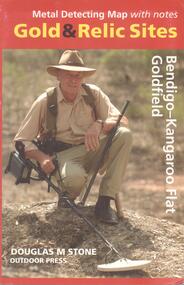
Map - METAL DETECTING MAP WITH NOTES: GOLD AND RELIC SITES - BENDIGO KANGAROO FLAT GOLDFIELD
... Map of the Bendigo and Kangaroo Flat Goldfields with key to diggings, structures, locations of nuggets previously found and topographical features. Enclosed in a coloured cardboard cover with photograph of gold detector....History House 11 Mackenzie Street Bendigo goldfields BHS Collection MAP Bendigo goldfields Douglas M Stone, Outdoor Press Map of the Bendigo and Kangaroo Flat Goldfields with key to diggings, structures, locations of nuggets previously found and topographical features. Enclosed in a coloured cardboard cover with photograph of gold detector. ...BHS CollectionMap of the Bendigo and Kangaroo Flat Goldfields with key to diggings, structures, locations of nuggets previously found and topographical features. Enclosed in a coloured cardboard cover with photograph of gold detector.Douglas M Stone, Outdoor Pressmap, bendigo, goldfields -
Beechworth Honey Archive
Map- Albury
... Map centred on Albury, showing Wodonga, Beechworth, Yackandandah and Chiltern. Topographic survey scale 1:100,000. Map is colour, printed on paper. ...Map centred on Albury, showing Wodonga, Beechworth, Yackandandah and Chiltern. Topographic survey scale 1:100,000. Map is colour, printed on paper. ...Map centred on Albury, showing Wodonga, Beechworth, Yackandandah and Chiltern. Topographic survey scale 1:100,000. Map is colour, printed on paper. Produced by Department of Minerals and EnergySheet 8225 (ed.1) series R. 652 Notes written on side regarding brigade boundaries, constructed access roads and fire trails, dams suitable for quick fill pump and areas 'fuel reduction burns Autumn 76'.map, albury, wodonga, beechworth, yackandandah, chiltern, paper, topographic, beechworth honey -
 National Vietnam Veterans Museum (NVVM)
Map, Intelligence Map
... Vinyl coated topographical map of part of Vietnam featuring main roads, towns and city locations current or ruined. ...National Vietnam Veterans Museum (NVVM) 25 Veterans Drive Newhaven phillip-island-and-the-bass-coast Map Vietnam Vinyl coated topographical map of part of Vietnam featuring main roads, towns and city locations current or ruined. ...Vinyl coated topographical map of part of Vietnam featuring main roads, towns and city locations current or ruined. River locations etc. Names all in Vietnamese language.map, vietnam -
 Bendigo Military Museum
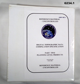
Manual - Digital Topographic Data Compilation Specification - Part 2 Planning Level Products, June 1998
... The purpose of this document is to provide digital Topographic data compilation specifications for the Australian Defence Force (ADF) which are applicable to all areas of the Area of Direct Military Interest (ADMI) for the collection of features and attributes to populate the ADF topographic database....Bendigo Military Museum 37 - 39 Pall Mall Bendigo goldfields The purpose of this document is to provide digital Topographic data compilation specifications for the Australian Defence Force (ADF) which are applicable to all areas of the Area of Direct Military Interest (ADMI) for the collection of features and attributes to populate the ADF topographic database. ...The purpose of this document is to provide digital Topographic data compilation specifications for the Australian Defence Force (ADF) which are applicable to all areas of the Area of Direct Military Interest (ADMI) for the collection of features and attributes to populate the ADF topographic database.6234.1 A four ringed Folder containing A4 Paper, White, Metal Bindings, Chapters 1 to 8 6234.2 A four ringed Folder containing A4 Paper, White, Metal Bindings, Chapters 8 to 13 and Annexesroyal australian survey corps, rasvy, fortuna, army survey regiment, army svy regt, asr, director of survey - army -
 Ballan Shire Historical Society
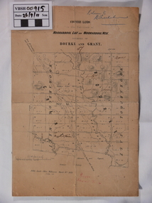
Map - Map. Moorarbool East and West, Country Lands in the Parishes of Moorarbool East and Moorarbool West. Counties of Bourke and Grant
... A relatively small map, paper on a material backing. Shows topographical features, roads and property divisions. ...A relatively small map, paper on a material backing. Shows topographical features, roads and property divisions. ...This is a map of "Country Lands" around the Werribee River, north of Ballan in the Counties of Bourke and Grant.A relatively small map, paper on a material backing. Shows topographical features, roads and property divisions. Scale of forty chains to one inch. The map is dated March 31st, 1859.There is a small inscription under the chain scale that reads "No 58/364 John Phillips ? Survey 1st August 1858". The name Dugald McPherson is hand written on one of the blocks of land.moorarbool west, moorarbool east, dugald mcpherson, county of bourke, county of grant, werribee river, ballan -
University of Melbourne, Burnley Campus Archives
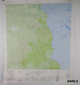
Map - Topographic Survey, Grampians, 1969
... Australia 1:100,000 Topographic Survey Map of the Grampians, Victoria dated 1969. ...University of Melbourne, Burnley Campus Archives 500 Yarra Boulevard Richmond melbourne grampians royal australian survey corps topographic survey Australia 1:100,000 Topographic Survey Map of the Grampians, Victoria dated 1969. ...Australia 1:100,000 Topographic Survey Map of the Grampians, Victoria dated 1969. Sheet 7323 (Edition 1) Series R 652. Produced by the Royal Australian Survey Corps.grampians, royal australian survey corps, topographic survey -
 National Vietnam Veterans Museum (NVVM)
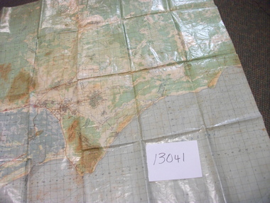
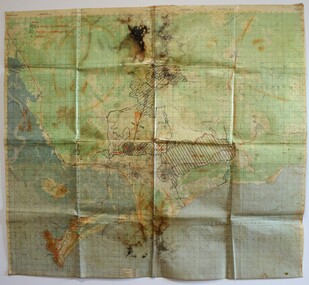
Map - Map, topographical, Vietnam 1:50,000, Sheet 6430
... ...Topographical...Standard issue map used by pilots during the war in Vietnam, dated 1966-1970 Pilot Map Topographical Vietnam bombing Vietnam 1:50,000. ...Standard issue map used by pilots during the war in Vietnam, dated 1966-1970A laminated map used by pilots giving information on terrain and specifics for bombing raids. Hand-made markings in red inkVietnam 1:50,000. Edition/-AMS:XUAT-BANLAN THUI- AMS-XA BINH BA/ SHEET 6430.TNAM Series L7014pilot, map, topographical, vietnam, bombing -
 Bendigo Military Museum
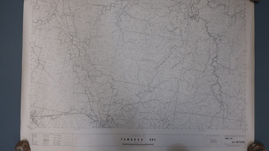
Poster - Map Production flow chart poster using Automap 2, Army Survey Regiment, Bendigo, 1982
... A topographic map of Series R631 1:100,000 Helenvale, Queensland printed on the reverse side that was produced by the Automap system using information from the topographic data base. ...A topographic map of Series R631 1:100,000 Helenvale, Queensland printed on the reverse side that was produced by the Automap system using information from the topographic data base. ...This poster designed to be folded into a brochure describes the second phase of the computer assisted cartographic system to be used by the Royal Australian Survey Corps in the establishment of a topographic data base, Future tactical applications and map products using the data base are displayed. A topographic map of Series R631 1:100,000 Helenvale, Queensland printed on the reverse side that was produced by the Automap system using information from the topographic data base. This is the fifth edition of the poster.A multi colour poster of map production using the Automap 2 system. Poster shows a schematic and pictorial flow chart diagram of the stages of the map production process using the Automap 2 system. The poster was intended to be folded into a small brochure. A 1:100,000 Army Survey Map Series R631, 7966 Helenvale, Queensland Edition 2 is printed on the reverse side of the poster. The map is an example of one of the initial maps produced on the Automap 2 System at the Army Survey Regiment, Bendigo.royal australian survey corps, rasvy, fortuna, army survey regiment, army svy regt, asr, automap 2 -
Creswick Campus Historical Collection - University of Melbourne
Map, 1937-1942
... Linen backed topographical Maps - Victoria. 26 folding maps...Creswick Campus Historical Collection - University of Melbourne 4 Water Street University of Melbourne Creswick Campus Building 719/718 Creswick goldfields Linen backed topographical Maps - Victoria. 26 folding maps School of Botany, Univerity of Melbourne Maps Map Map ...Linen backed topographical Maps - Victoria. 26 folding mapsMapsSchool of Botany, Univerity of Melbourne -
Creswick Campus Historical Collection - University of Melbourne
Map, 1937-1942
... Linen backed topographical Maps - Victoria. 21 folding maps...Creswick Campus Historical Collection - University of Melbourne 4 Water Street University of Melbourne Creswick Campus Building 719/718 Creswick goldfields Linen backed topographical Maps - Victoria. 21 folding maps School of Botany, Univerity of Melbourne Maps Map ...Linen backed topographical Maps - Victoria. 21 folding mapsMapsSchool of Botany, Univerity of Melbourne -
University of Melbourne, Burnley Campus Archives
Map - Topographic Survey, Ararat, 1970
... Australia 1:100,000 Topographic Survey map of Ararat district, Victoria dated 1970. ...Produced by the Royal Australian Survey Corps. Ararat Map Topographic Survey ...Australia 1:100,000 Topographic Survey map of Ararat district, Victoria dated 1970. Sheet 7423 (Edition 1) Series R 652. Produced by the Royal Australian Survey Corps.royal australian survey corps, ararat area, stawell area -
Tarnagulla History Archive
Photocopies of historic maps - Tarnagulla region, varied
... Four photocopies in clear sleeve: (a) topographic with mines near Tarnagulla (b) Parish map ?...Four photocopies in clear sleeve: (a) topographic with mines near Tarnagulla (b) Parish map ? ...David Gordon Collection. Four photocopies in clear sleeve: (a) topographic with mines near Tarnagulla (b) Parish map ?- Tarnagulla & surrounds (c) Parish map ?- Tarnagulla & surrounds (d) Plan of Roads, Tarnagulla & Newbridge -
 Bendigo Military Museum
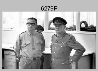
Photograph - Visit to Army Headquarters Survey Regiment, Fortuna, Bendigo by D-SVY COL Frank Buckland OBE, c1971
... This photo of WO2 Don Taylor and D-SVY COL Frank Buckland OBE was taken during a tour by D-SVY through Topographic Squadron at the Army Headquarters Survey Regiment, Fortuna, Bendigo circa 1971. ...This photograph of the Royal Australian Survey Corps (D-SVY) COL Frank Buckland OBE was taken during a D-SVY tour through Topographic Squadron, at the Army Headquarters Survey Regiment, Fortuna, Bendigo circa 1971. ...Bendigo Military Museum 37 - 39 Pall Mall Bendigo goldfields This photo of WO2 Don Taylor and D-SVY COL Frank Buckland OBE was taken during a tour by D-SVY through Topographic Squadron at the Army Headquarters Survey Regiment, Fortuna, Bendigo circa 1971. ...This photo of WO2 Don Taylor and D-SVY COL Frank Buckland OBE was taken during a tour by D-SVY through Topographic Squadron at the Army Headquarters Survey Regiment, Fortuna, Bendigo circa 1971. Wild B8 Aviograph Stereoplotters are visible inside the windows in the background. BRIG Frank Buckland OBE served in the Australian Army from 01 June 1938 to 31st of October 1972. LTCOL Frank Buckland was the CO of the Army Headquarters Survey Regiment from 1962 to 1965. After promotion to COL Buckland was appointed as Director of the Royal Australian Survey Corps from March 1967 to August 1972. COL Buckland was promoted to Brigadier (retired) to the honorary position as Colonel Commandant from January 1973 to January 1976. WO2 Don Taylor served in the Australian Army from 24th October 1960 to 31st December 1987 and ended his service as a commissioned officer and reached the rank of Major. He was the OC of 4th Field Survey Squadron, Adelaide SA for several years.This photograph of the Royal Australian Survey Corps (D-SVY) COL Frank Buckland OBE was taken during a D-SVY tour through Topographic Squadron, at the Army Headquarters Survey Regiment, Fortuna, Bendigo circa 1971. The black and white photograph was printed on photographic paper and is part of the Army Survey Regiment’s Collection. The photograph was scanned at 300 dpi. .1) - Photo, colour, c1971, L to R: WO2 Don Taylor, Director of the Royal Australian Survey Corps COL Frank Buckland OBE. There are no annotations.royal australian survey corps, rasvy, army survey regiment, army svy regt, fortuna, asr -
 National Vietnam Veterans Museum (NVVM)
Document, Restricted Intelligence Centre
... Six pages marked Index 2: Intelligence Centre - Topographical Interpretation Vegetation in S.E Asia - eight pages...Six pages marked Index 2: Intelligence Centre - Topographical Interpretation Vegetation in S.E Asia - eight pages Restricted Intelligence Centre Document Document ...Yellowing paper Restricted 1: Army Intelligence Ctnre - Revolutionary Warfare - General. Six pages marked Index 2: Intelligence Centre - Topographical Interpretation Vegetation in S.E Asia - eight pagesdocument, restricted intelligence centre -
Federation University Historical Collection
Map, Creswick Gold Field Map, 1981
... Geologically and topographically surveyed by Ferdinand M Krause. ...See 116 creswick krause surveyor smeaton spring hill tourello ascot dean bullarook gold fields gold Geologically and topographically surveyed by Ferdinand M Krause. ...A fragment of the original 1880 map is also held in the collection. See 116Rectangular geological map with brown paper strip on top edge with 4 holes on top edge. Scale is 40 chains to one inch.Geologically and topographically surveyed by Ferdinand M Krause. Lithographed by R. Shepherd. Printed by J. Finnie. Mining Department, Melbourne. Preprinted with additional shaft and lead detail. F. D. Atkinson, Government Printer 1981creswick, krause, surveyor, smeaton, spring hill, tourello, ascot, dean, bullarook, gold fields, gold -
 Kiewa Valley Historical Society
Maps - Tawonga and Feathertop
... 1. Topographical Map - Tawonga 803 Forests Commission of Victoria 1968. ...Historical use of land in Tawonga and Feathertop. tawonga map 1968 tawonga parishes feathertop map 1969 1. Topographical Map - Tawonga 803 Forests Commission of Victoria 1968. ...Plan of Tawonga showing roads etc, rivers, use of land in 1968 and of Feathertop in 1969.Historical use of land in Tawonga and Feathertop.1. Topographical Map - Tawonga 803 Forests Commission of Victoria 1968. Cream paper with black print. Legend: Roads, tracks etc, rivers, Parishes and use of land. 2. Feathertop 813. 1969tawonga map 1968, tawonga parishes, feathertop map 1969 -
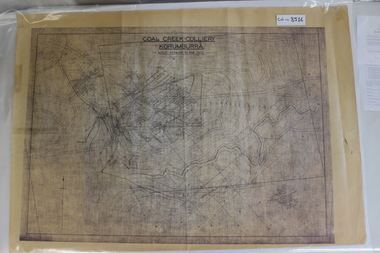 Coal Creek Community Park & Museum
Map of Mine and Details, Coal Creek Colliery Korumburra
... 8516.1 - Schematic/map of coal creek mine workings, also detailing number surface features such as topographic heights, roads, railways, boreholes, etc. ...Coal Creek Community Park & Museum 12 Silkstone Road Korumburra gippsland 8516.1 - Schematic/map of coal creek mine workings, also detailing number surface features such as topographic heights, roads, railways, boreholes, etc. ...8516.1 - Schematic/map of coal creek mine workings, also detailing number surface features such as topographic heights, roads, railways, boreholes, etc. No Legend. Most information seems to be printed, with topography drawn on. -
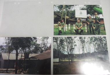 National Vietnam Veterans Museum (NVVM)
Photograph
... Seven Khaki clad men in front of sign Royal Australian Survey Corps 1st Topographical Survey Troop 2+3. Scenes of building and trees...Seven Khaki clad men in front of sign Royal Australian Survey Corps 1st Topographical Survey Troop 2+3. Scenes of building and trees Photograph Photograph ...Three Colour Photograph taken in Vietnam 1. Seven Khaki clad men in front of sign Royal Australian Survey Corps 1st Topographical Survey Troop 2+3. Scenes of building and treesphotograph, royal australian survey corps -
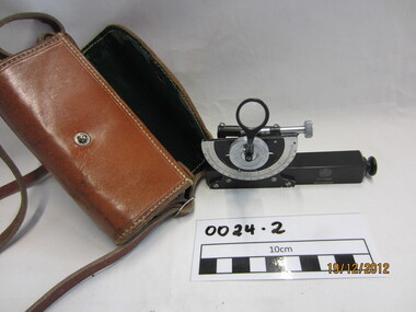 Wannon Water
Clinometre / Abney Level, E. R. Watts & Son, Clinometre
... Abney Level / Clinometer is an accurate surveying tool used to measure degrees, percent of grade and topographic elevation. ...Wannon Water 25 Gateway Road Warrnambool great-ocean-road Abney Level / Clinometer is an accurate surveying tool used to measure degrees, percent of grade and topographic elevation. Used for surveying pipe lines. ...Abney Level / Clinometer is an accurate surveying tool used to measure degrees, percent of grade and topographic elevation. Used for surveying pipe lines.Instrument which consists of a fixed sighting tube, a movable spirit level connected to a pointing arm which turns and pivots. Adjustment knob/screw on top turns to rotate the compass indicator and bubble level. Arched scale graduated 0 to 90 degrees in both directions. Clinometer is housed in a brown leather case with a long leather strap for carrying around the neck.Watts London / No 70131 / Made in England -
Glenelg Shire Council Cultural Collection
Book, M.M. CRAWFORD, Ourselves and the Pacific, c. 1943
... Front endpaper, trade and population map, green and whte back endpaper, topographical map of the Pacific, green and white...Front endpaper, trade and population map, green and whte back endpaper, topographical map of the Pacific, green and white Ourselves and the Pacific Book Book M.M. ...Hardback green, blue print, history of nations bordering Pacific Ocean, black and white maps. Front endpaper, trade and population map, green and whte back endpaper, topographical map of the Pacific, green and whitehistory, pacific, geography -
 Bendigo Military Museum
Album - Photographic Identification Guide (PIG) of the Gove Penisula (Sic) Peninsula, Army Topographic Support Establishment, May 1997
... These photographs and a video were captured in May 1997 by Jeff Ruiz and Wayne Walsh from the Army Topographic Support Establishment (ATSE). The video taken onboard an aircraft has not been located at this time. ...Bendigo Military Museum 37 - 39 Pall Mall Bendigo goldfields These photographs and a video were captured in May 1997 by Jeff Ruiz and Wayne Walsh from the Army Topographic Support Establishment (ATSE). The video taken onboard an aircraft has not been located at this time. ...These photographs and a video were captured in May 1997 by Jeff Ruiz and Wayne Walsh from the Army Topographic Support Establishment (ATSE). The video taken onboard an aircraft has not been located at this time. A flight line diagram showing the path of the aircraft taking the video is enclosed in the album. The Army Topographic Support Establishment was created to perform some of the functions of the Army Survey Regiment.A Large Purple covered Album with gold dots containing maps, plans and coloured photographs of Gove Peninsula.royal australian survey corps, rasvy, fortuna, army survey regiment, army svy regt, asr, atse -
 Bendigo Military Museum
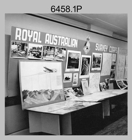
Photograph - Royal Australian Survey Corps role and technical capabilities display, c1960s
... Map products formed a large part of this topographic Support. The photos may have been taken at a Careers Expo or a Department of Defence promotion. ...Map products formed a large part of this topographic Support. The photos may have been taken at a Careers Expo or a Department of Defence promotion. ...This is a collection of four photographs taken in the 1960s of Royal Australian Survey Corps displays promoting its role and technical capability to acquire, process and disseminate topographic information to the Australian Defence Force. Map products formed a large part of this topographic Support. The photos may have been taken at a Careers Expo or a Department of Defence promotion. It is possible the photos were taken at separate events. This is a collection of four photographs taken in the 1960s of Royal Australian Survey Corps displays promoting its role in Defence and technical capabilities. The black and white photographs were printed on photographic paper and are part of the Army Survey Regiment’s Collection. The photographs were scanned at 300 dpi. .1) to .4) - Photo, black & white, 1960s. Royal Australian Survey Corps Display at unknown location.There are no annotations.royal australian survey corps, rasvy, army survey regiment, army svy regt, fortuna, asr -
 Bendigo Military Museum
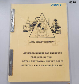
Administrative record - An Error Budget for Products produced by the RASvy Corps, Major Edward J Wright US Army Corps of Engineers, 1988
... This document is an analysis determining the positional accuracy (size of errors) within Topographic Mapping Products produced by the Royal Australian Survey Corps....Bendigo Military Museum 37 - 39 Pall Mall Bendigo goldfields This document is an analysis determining the positional accuracy (size of errors) within Topographic Mapping Products produced by the Royal Australian Survey Corps. ...This document is an analysis determining the positional accuracy (size of errors) within Topographic Mapping Products produced by the Royal Australian Survey Corps.A yellow carboard covered booklet, 2 x "ARNOS" fasteners, Army Survey Regiment Unit emblem designed by SSgt Denis MacCarthy.royal australian survey corps, rasvy, fortuna, army survey regiment, army svy regt, asr -
 Bendigo Military Museum
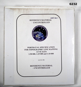
Manual - Portrayal Specification for Topographic Line Mapping at Scales1:50,000, 1:25,000 and 1:10,000, 16.07.1998
... These specifications enabled the hard copy representation of digital topographic data for the Australian Defence Force (ADF) covering Australia and nearer regions....Bendigo Military Museum 37 - 39 Pall Mall Bendigo goldfields These specifications enabled the hard copy representation of digital topographic data for the Australian Defence Force (ADF) covering Australia and nearer regions. ...These specifications enabled the hard copy representation of digital topographic data for the Australian Defence Force (ADF) covering Australia and nearer regions.Plastic covered white four ring binder, 14 Chapters, 4 Annexesroyal australian survey corps, rasvy, fortuna, army survey regiment, army svy regt, asr, director of strategic military geographic information, dsmgi -
 Federation University Historical Collection
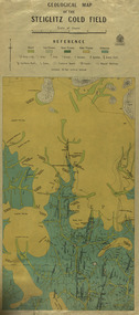
Map, Geological Map of The Stieglitz Gold Field, 1940
... At the bottom of the 2nd page, there is text that reads "Geologically and topographically surveyed in 1909 by W.H. Ferguson, Assistant Field Geologist. ...Barker Library (top floor) Mount Helen goldfields At the bottom of the 2nd page, there is text that reads "Geologically and topographically surveyed in 1909 by W.H. Ferguson, Assistant Field Geologist. ...At the bottom of the 2nd page, there is text that reads "Geologically and topographically surveyed in 1909 by W.H. Ferguson, Assistant Field Geologist. Published 1940."Rectangular geological map edged in masking tape showing Steiglitz, Victoria. Scale 48 chains to 4 inches.steiglitz, geology, geological map, north albion, moreep, mining, mine, caribald reef, durdidwarrah, gilbraltar hill, mount pleasant gully, township of steiglitz, w.h. ferguson, garibaldi reef, yankee gully, kinglock mine engine shaft, herbert werner frederick de nully, albion gully, virago reef, mulrooney's reef -
 Eltham District Historical Society Inc
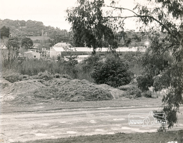
Photograph, N. J. Tillings Timber Factory, 15 June, 1975, 15/06/1975
... Photograph shows topographical features of the valley and how sound travels upwards and outwards to residential zones surrounding." ...Photograph shows topographical features of the valley and how sound travels upwards and outwards to residential zones surrounding." 1 black and white photograph printed with white border on three sides N. ...Piles of dirt alongside dirt road, part of the light industrial area including N. J. Tillings Timber Factory, Brougham Street, Eltham. This is one of 7 B/W 8x10 inch photos with notes on obverse by Dick Crichton. Accompanying letter from Florence Chrichton 2013 : "Originally sent to Shire of Eltham Engineer, Mr. McDonald. [These photographs were part of their campaign to the Shire of Eltham in 1975] claiming that the zoning regulations were being breached by the occupants of various factories in the nearby light industrial zone [Brougham Street, Eltham] - to the detriment of those living in adjoining residential zones, and that, despite .. earlier objections and complaints, nothing was done about it." 1 black and white photograph printed with white border on three sidesInscribed on back: "View from residential premises in Brougham Street. Trees in foreground will soon be lost due to making of the main drain by M.M.B.W.. Photograph shows topographical features of the valley and how sound travels upwards and outwards to residential zones surrounding." industrial estate, brougham street, eltham, 1975, bolton street, dick crichton, n.j. tillings, timber factory, shire of eltham