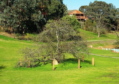
Showing 300 items
matching trees along the road
-
 Marysville & District Historical Society
Photograph (item) - Black and white photograph, Rose Stereograph Company, Cumberland Falls, Marysville, 1913-1967
An early black and white photograph of Cumberland Falls near Marysville in Victoria.An early black and white photograph of Cumberland Falls near Marysville in Victoria. These falls are located on the Marysville-Wood's Point Road. Cambarville is notable for its giant mountain ash (Eucalyptus regnans) trees within the Cumberland Memorial Scenic Reserve, and relics from former sawmills and gold mining. The Big Culvert is located nearby on the Marysville - Woods Point Road, which was historically part of the Yarra Track. Cambarville was established as a timber mill town in the 1940s. Timber mill owners A Cameron and FJ Barton named Cambarville. They established the mill to salvage timber from trees destroyed in the 1939 bushfires. Cambarville was impacted by the 2009 Black Saturday bushfires and any remaining structures were destroyed. The photograph was also used to produce the Rose Series postcard P. 2328.marysville, victoria, photograph, waterfalls, cumberland falls, p. 2328, rose series postcard, souvenir, rose stereograph company, cambarville, marysville-wood's point road, mountain ash, eucalyptus regnans, cumberland memorial scenic reserve, mining, timber milling, big culvert, a cameron, fj barton, black saturday bushfires -
 Nhill Aviation Heritage Centre
Black and White photograph, Possibly Dept of Defence photograph, Nhill RAAF Base
The Nhill RAAF Base was built during WWII as part of the Empire Air Training Scheme (EATS Scheme)This is believed to be the first aerial photo taken of the RAAF Base. Aerial photograph of the Nhill RAAF base thought to be taken late 1941 or early 1942. Notice that only two of five Bellman Hangers have been built and trees have not been planted along the driveway into the base.raaf, 1941, base -
 Federation University Historical Collection
Photograph, Site of Sovereign Hill and Ballarat Lodge
The Old Ballarat Travel Inn was located at 613 Main Road. It later Became Ballarat Lodge and Mecure Ballarat.Photograph showing the site of Sovereign Hill in fron to the pine trees, and Elsmore street running along the right. Ballarat Lodge, the brainchild of John Gilbert, can be seen in front of the dam in the centre. The start of Magpie Street can be seen on the left hand side of the photograph.ballarat lodge, john gilbert, sovereign hill, elsmore street, main road, ballarat east, old ballarat travel inn -
 Phillip Island and District Historical Society Inc.
Photograph - Post Card, Cowes School Back to 1926 Chapel Street, March 1926
Donated by Stan McFee from the Keith McIlwraith CollectionSepia postcard of four cars , decorated with streamers, driving along Chapel Street going west on unmade road. Land on left was owned by Methodist Church, corner of Chapel and Bass Ave., where large tree denotes the boundary. Finley? Forrest's house on right. Coming to Back to Cowes School Celebration March 1926On back: "Back to Cowes March 1926"celebrations - back to cowes school phillip island, decorated cars, phillip island, stan mcfee, keith mcilwraith collection -
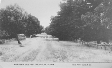
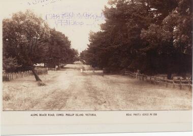 Phillip Island and District Historical Society Inc.
Photograph, Early 20th Century
One of 20 photographs/postcards donated by Mary KarneySepia photograph copy of a postcard. Beach Road, Cowes with fences and trees lining the road."Along Beach Road, Cowes, Phillip Island, Victoria." "Real Photo Series M 1258"beach road, cowes phillip island, cowes phillip island, mary karney -
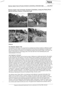 Greensborough Historical Society
Document - Report, Samantha Westbrooke et al, Batman Apple Tree, & Pioneer Children's Cemetery, Greensborough, 2012, 2012_07
A history of the Batman Apple Tree and Pioneer Children's Cemetery along the Plenty River. Prepared by Samantha Westbrooke Pty Ltd in association with Peter Mills, historian. The Batman Apple tree is said to be over 170 years old, being brought to Greensborough in the 1840s from the Melbourne orchard of John Batman, following Batman's death in 1839. The Pioneer Children's Cemetery is the burial place of 7 children from the Whatmough and Partington families who dies between 1845 and 1858.11 page photocopy, text and black and white illustrations.batman apple tree, robert whatmough, plenty river trail, pioneer childrens cemetery -
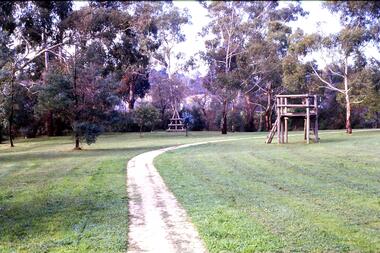 Greensborough Historical Society
Slide - Photograph, John Ramsdale, Along the Plenty River Trail: Slide 7, 1990s
Photograph shows park with narrow path, trees and timber play equipment taken along the Plenty River Trail.Part of the John Ramsdale collection of slides and audio visual material.Colour photograph scanned from slide.No maker's marks. No caption on slide.plenty river trail, greensborough, banyule parks -
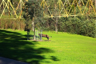 Greensborough Historical Society
Photograph - Digital Image, Marilyn Smith, The Separation Tree Greensborough 2019, 02/07/2019
The original Separation Tree was one of two red river gums that pre-dated European occupation, and was the site where colonists congregated to celebrate the announcement of Victoria's separation from New South Wales on 15 November 1850. It died as the result of vandalism in 2010 and 2013. Saplings of the original were planted around Melbourne in 2014, including this one along the Plenty River Trail in Greensborough. The old aqueduct bridge can be seen in background.2 colour digital photographsseparation tree, plenty river trail, aqueduct pipe bridge greensborough -
 Greensborough Historical Society
Photograph - Digital Image, Marilyn Smith, Batman Apple Tree Greensborough 2019, 02/07/2019
The Batman Apple Tree is said to be the oldest apple tree in Victoria and came from the remnants of John Batman's orchard after his death. In the 1840s, this area was Frederick Flintoff's orchard on land called Brancepeth Farm. The tree is located along the Plenty River Trail in Greensborough. 3 colour digital photographsplenty river trail, batman apple tree, john batman, frederick flintoff, brancepeth farm -
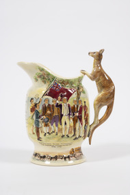 Lorne Historical Society
Souvenir - Musical jug, Crown Devon Fieldings, c. 1935
Bone China jug, with kangaroo shaped handle with hand painted relief scenes First Nations Peoples brandishing spears at Captain Cook’s sailors, Captain Cook taking possession of the country at Botany Bay April 1770 The words to Advance Australia Fair are also printed . Along the base is a color painted relief of a bullock cart containing logs.souvenirs, captain cook, botany bay, advance australia fair, indigenous, kangaroo, endeavour -
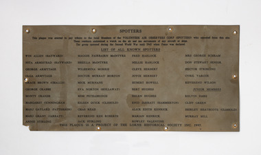 Lorne Historical Society
Plaque - Spotters Plaque, Tribute plaque to the local Members of the Volunteer Air Observers Corps ( spotters)
In World War 2 residents of Victoria were concerned about enemy attack so a series of Spotters Huts were established along the coast. In Lorne the Spotters Hut was at Queenspark in the old recreation building. Many locals volunteered their time. The plaque was made by the Lorne Historical Society to honour these people who volunteered to join the Air Observers Corp. A rectangular thin Metal sheet , with black printing. This plaque was made in 1997 as a project of the Lorne Historical Society to pay tribute to the Spotters who worked in the spotters cabin at Queens Park Lorne during the Second World War. It listed all the names of the know Spotters, Win Allen, Nita Armistead, George Armitage, Olga Armitage, Grace Brown, George Crabbe, Monty Craig’s, Margaret Cunningham, Marj Gaylord, Marj Grant, Annie Stirling, Margie Fairbairn, Sheila McIntyre, Wilhemena Morris, Murray Morton, Nick Murnane, Eva Norton, Miss Pethabridge, Eileen Quick, Chas Read, Rev Ken Robert’s, Jack Stirling, Fred Harlock, Nellie Harlock, Cleve Herbert, Joyce Herbert, Hubert Howell, Bert Hughes, Helen Hughes, Enid Jarrett, Alice Kendrick, Marion Kendrick, Rowley Valentine, Mrs G Schram, Don Stewart , Hector Stribling, Cyril Barcoe, Rev Wilson, Kevin Dare, Cliff Green, Shirley Heathcote, Murray Milne. The plaque was placed on the Spotters Hut in 1997 but removed when the hut was remodeledspotters, world war 2, queens park, second world war -
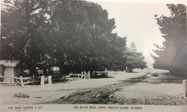 Phillip Island and District Historical Society Inc.
Photograph, The Beach Road, Ccowes
Part of a collection of 'Rose & Valentine' series of Post Cards. Copied by John Jansson 1984View along the Beach Road, Cowes looking towards the Isle of Wight Hotel on left of photograph (hidden by the trees).The Beach Road, Cowes Phillip Island Vic. The Rose Series P.674.local history, photography, photographs, postcards, cowes, phillip island, black & white photograph, the esplanade cowes, isle of wight hotel -
 Phillip Island and District Historical Society Inc.
Photograph, Unmade road in Cowes
Part of a collection of 'Rose & Valentine' series of Post Cards. Copied by John Jansson 1984View of a beach road, Cowes. Unmade, grassy, tree lined street.Along Beach Road, Cowes, Phillip Island, Victoria. Real Photo Series M1256local history, photography, photographs, postcards, cowes, phillip island, black & white postcard copy, phillip island early roads -
 Phillip Island and District Historical Society Inc.
Photograph, Bryant West, 1959
One of a collection of over 400 photographs in an album commenced in 1960 and presented to the Phillip Island & Westernport Historical Society by the Shire of Phillip IslandPhotograph of Ventnor Reserve looking north along the wire netting fence fronting Ventnor Road and showing ornamental trees with young Manna Gums behind.Notice in foreground...Planted by Phillip Island Tree Planters Association assisted by Phillip Island School Children.local history, photography, photographs, ventnor reserve, manna gums, john jenner, bryant west -
![Newspaper Clipping - Digital Image, Act at home to help the earth [Greensborough Primary School Gr2062], 18/06/2001](/media/collectors/4f729f5697f83e03086015b8/items/5bb9789021ea6716dc37f527/item-media/5bb978bd21ea6716dc382477/item-fit-380x285.jpg) Greensborough Historical Society
Greensborough Historical SocietyNewspaper Clipping - Digital Image, Act at home to help the earth [Greensborough Primary School Gr2062], 18/06/2001
Students from Greensborough Primary School planted trees along the Plenty River, assisted by Mayor of Banyule Councillor Dale Peters.Newspaper clipping, black and white text and colour image.greensborough primary school, plenty river, dale peters -
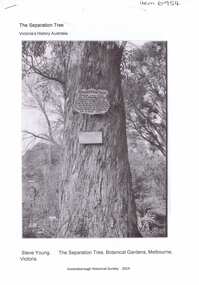 Greensborough Historical Society
Article, The Separation tree, 2019_
The tree was one of two original red river gums that pre-dated European occupation, and was the site where colonists congregated to celebrate the announcement of Victoria's separation from New South Wales on 15 November 1850. It died as the result of vandalism in 2010 and 2013. Saplings of the original are planted around Melbourne, including along the Plenty River Trail in Greensborough3 p. Wikipedia article; photograph of the tree in the Botanical Gardens, Melbourne (before it was vandalised), and copy of the document of separation of the province of Victoria from the Colony of New South Wales, owned by Colin Boucher..separation tree -
 Glenelg Shire Council Cultural Collection
Photograph - Photograph - LB / TB, n.d
Port of Portland Authority Archivesport of portland archives -
 Greensborough Historical Society
Photograph - Digital image, Jasmin Burge, Grimshaw Street trees 2012, 19/06/2012
Trees along the Grimshaw Street boundary of Loyola College. Part of a collection of photographs of Loyola College, Grimshaw Street Watsonia, established 1980 on the site of the Loyola Seminary. The College purchased the original building in 2002. These photographs of the original building and grounds were taken by GHS member Jazz Burge in June 2012.Digital copy of 2 colour photographs.loyola college, grimshaw street -
 Greensborough Historical Society
Photograph - Digital image, Jasmin Burge, Trees, Loyola 2012, 19/06/2012
Trees along boundary fence, Loyola College 2012. Part of a collection of photographs of Loyola College, Grimshaw Street Watsonia, established 1980 on the site of the Loyola Seminary. The College purchased the original building in 2002. These photographs of the original building and grounds were taken by GHS member Jazz Burge in June 2012.Digital copy of colour photograph.loyola college -
 Greensborough Historical Society
Photograph - Digital image, Marilyn Smith, Plenty River bank at Greensborough 2015; Tree, 16/08/2015
This photo shows examples of trees growing beside the Plenty River in Greensborough. A River bank stabilisation project along the Plenty River at Greensborough was conducted by Melbourne Water in 2015.Digital copy of colour photographplenty river, melbourne water -
 Greensborough Historical Society
Photograph - Digital image, Marilyn Smith, Plenty River bank at Greensborough 2015; Trees, 16/08/2015
Tree on bank of Plenty River in Greensborough. A River bank stabilisation project along the Plenty River at Greensborough was conducted by Melbourne Water in 2015.Digital copy of colour photographplenty river, melbourne water -
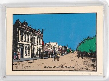 Glenelg Shire Council Cultural Collection
Print - Print - Bentinck Street, 1984
CEMA Art Collection Part of "A Community View" 150 years in Portland Screenprint Exhibition Part of the Angela Gee Residency 1983 and 1984Laminated screenprint depicting an early street scene of Bentinck Street in Portland. The left side of the work depicts the row of buildings along Bentinck Street with the 'Gordon Hotel' in the foreground. In the centre of the image two figures on horses ride away from the viewer. On the right is a large tree with with two figures walking below it.Front: Karina Fredericks 84' (lower right) (pencil) Back: 9 -
 Glenelg Shire Council Cultural Collection
Mixed media - Photocard - Colour Panorama, Portland Bay, Colour Panorama, Portland Bay, n.d
Displayed at History HouseTinted photo. Baths with blue roof in foreground. Fisherman's Wharf in background, Long Pier, Railway Pier, and Cypress Trees along Bentinck Street. Telegraph Poles along Street. Truck carrying bales. Mounted on cardboard.Front: Panorama of Portland, Victoria (Length of Ocean Pier, 2880 ft). -
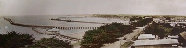
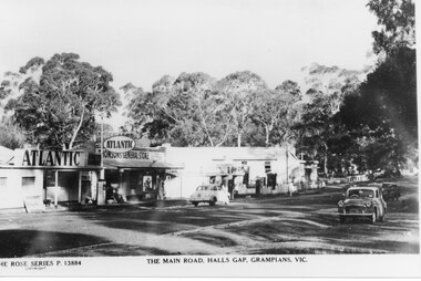 Halls Gap & Grampians Historical Society
Postcard - B/W, C 1950s
... A strip of shops along a bitumen road. One shop...". There are several cars parked along the road and eucalyptus trees ...Thomson's and Taylor's shops with the Halls Gap Hall further along the road. A number of 1950's vintage cars are parked along the main road. No. 13884 in the Rose Series of postcards.A strip of shops along a bitumen road. One shop is a garage with Atlantic signs and another has a sign that reads "Thomson's General Store". There are several cars parked along the road and eucalyptus trees in the background.buildings, shops -
 Halls Gap & Grampians Historical Society
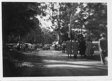
Photograph - B/W, C 1950
Halls Gap Grampians Camping reserve on Flower Show Day in 1950. This is the main road looking towards the stores from Grampian House.The photo shows a road with trees growing on either side. There are cars parked on either side of the road and people standing and walking along the road. In the centre there are two cars driving along the road towards the camera.events, wildflower show -
 Halls Gap & Grampians Historical Society
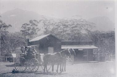
Photograph - B/W
c Early 1900's. Borough Huts were originally used to house the workers for the Stawell Water Supply system, later used for holiday accommodation. For Further information see " Victoria's Wonderland p37,63,79-80,93,107.Four people sitting in a dray, two men in the front and two ladies in the back. Two horses are in the traces. They are in front of a weather board building with a galvanised iron roof, a veranda runs along the front of the building. Tall gum trees are behind the building, a mountain range can be seen vaguely in the background.water supplies, borough huts, buildings, shops -
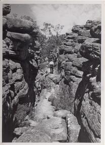 Halls Gap & Grampians Historical Society
Photograph - B/W, C 1960s
Photo is of area known as ' Silent Street'. It is on path to Pinnacle Lookout.Photo shows a man walking along slabs of rock that form a path between rocky outcrops. He is walking away from the camera. Various shrubs line the path. Gum trees can be seen in background.'Copyright photograph'. This photograph may be reproduced on condition that it is acknowledged as 'Victorian Railways Photograph', p3456- Silent Street . Halls Gap.scenery, wonderland range -
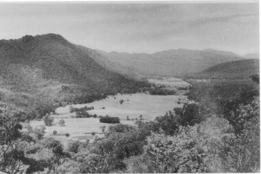 Halls Gap & Grampians Historical Society
Photograph, C 1940 -50s
Valley is now known as Fyans Valley but in the 1840-50s it was called Lady Mary's Vale. See p. 111 of 'Victoria's Wonderland' for historical information.A valley with a cleared area stretching along the valley floor. A mountain range runs along the left and into the distance of the photograph. a rocky outcrop, bushes and trees appear in the front and right of the photo. c 1940-1950sscenery, fyans valley -
 Eltham District Historical Society Inc
Photograph, Spring Excursion, Hume and Hovell bus tour Stage 2, Seymour, Benalla; 26 Oct 1997, 26/10/1997
MONUMENT HUNTING THE HUME AND HOVELL WAY (Newsletter No. 117, November 1997, by Diana Bassett-Smith) Sunday October 26 1997 dawned bright and very warm. Some twenty-five members, complete with picnic baskets, met outside the Eltham Library awaiting the Cobb and Co. large coach which would be taking us on the second leg of our travels along the route of the early explorers Hume and Hovell. Stephen West was our very good driver for the day. He would be guided around the circuitous route by Russell Yeoman wh9 had made a detailed study, not only of the intended route, but of the story of these two explorers. During the trip Russell regaled us with poetry, quotations from the Journals and the History of the Shire of Seymour, "The New Crossing Place: by Martindale, 1982, (now Mitchell Shire due to the recent amalgamations). We headed towards the Hume Highway via Greensborough and Cooper Street and proceeded north to our first stop, noting on the way Monument Hill in the distance which is near Kilmore and, according to Russell, well worth the effort to visit as the view across the valley is magnificent. Past Sunday Creek Valley, Mt Piper and Mt Disappointment, all traversed and noted and named by them. We passed through Tallarook, then onto Seymour where we took photos of the monument telling us that Hume and Hovell had passed through on the 28th of October 1824. We also deviated down Hume and Hovell Road viewing deer and emu farming and the Bellbourie property now a sanctuary. Leaving Seymour behind we travelled up the Avenel Road to the Avenel monument, pyramidal in design of four reducing square blocks with a sharply pointed peak, erected in 1924 in memory of the 1824 exploration. The day was warming up and the countryside showing the dryness of the current drought. A parallel note had been made in their journal too of 1824 of the drought appearance of the country they were traversing. At Seven Creeks, Euroa we stopped for some minutes to check the monument placed 20th November 1924 to commemorate their passage on the 29th December 1824. More photos. Russell had pointed out the abrupt termination of the distant ranges which is noted in their journal. The next monument is beside the road at the entrance to Honey Suckle Creek Caravan Park, Violet Town. The squarish shaped monument some eight feet high is topped with a simple steel cross, and was to mark the date of 28th December 1824 and built for the 20th November 1924. By now it was 12.20 and nearly lunchtime as we drove along the Warranbayne Road to Roach's Road, monument hunting without success. Though there is a large, what appears to be an old timber sign which was hard to read, maybe this was the lost monument. In many of the paddocks hay had been cut and baled or was being cut, what a contrast to the rugged country they had passed through which was smoky from the fires of the natives burning off By 1.00 pm we were at Benalla and pulled up beside the park where abundant beds of roses filled the air with their scent and the smell of barbecued food twitched the nostrils whilst the cheerful sounds of other picnickers could be heard throughout the park. We left the bus and collected up our picnics, dispersed to the various tables and enjoyed the shade from the various European trees. 2.00 pm and we were on the road again driving along the Benalla, Mansfield, Yea road. The Swanpool monument states that they passed four miles south and returned three miles north. Then we stopped at the Barjarg monument which notes that they camped near this spot. It is again a pyramidal monument and this time topped with a steel arrow indicating their route of the 29th November 1824. Half an hour later we came to another monument, again with a steel arrow marker on top and the plaque dated the 2nd of 12th 1824. Erected on the 12th of 12th 1924. "They blazed the way that we might inherit the land." Another square based and needle topped monument appeared at Yarck near Yea and this plaque records the date of 3 December 1824. Near McGuigans Road Russell related that the expedition had lost a dog but it had found them next day, the dog was apparently torn by a kangaroo. A short while later Russell reminded us here of the problems they encountered in crossing the Goulburn River near Molesworth where banks were high, water deep and wide. "Good coat of grass but quite dry due to drought". At Yea we stopped for afternoon tea and raided the last of our picnics and looked at the monument to their journey of 1824, situated at a corner of the gardens near the bowling green. No photo – we were out of film. We returned home via Kinglake West and Whittlesea past the Yan Yean Reservoir, not full. 5.00 pm back at Eltham we emptied out of the bus and everyone, including Joan Cole, collected their things, Joan also had the major souvenir of the day, a large carp she had picked up from the river bank, her cat was in for a great feast. The day was made so interesting by the informed commentary which Russell provided. His background knowledge of the route and nature of the journey could only have come from many hours of reading and driving the area. Thank you to Russell and to everyone who made the day so informative and pleasurable. Diana Bassett-Smith. Record of the Society's history of activities - Spring 1997 excursionRoll of 35mm colour negative film, 6 stripsFuji 200shire of eltham historical society, activities, pretty hill, seymour, benalla, hume and hovell, monuments -
 Eltham District Historical Society Inc
Photograph, Spring Excursion, Hume and Hovell bus tour Stage 2, Seymour, Benalla; 26 Oct 1997, 26/10/1997
MONUMENT HUNTING THE HUME AND HOVELL WAY (Newsletter No. 117, November 1997, by Diana Bassett-Smith) Sunday October 26 1997 dawned bright and very warm. Some twenty-five members, complete with picnic baskets, met outside the Eltham Library awaiting the Cobb and Co. large coach which would be taking us on the second leg of our travels along the route of the early explorers Hume and Hovell. Stephen West was our very good driver for the day. He would be guided around the circuitous route by Russell Yeoman wh9 had made a detailed study, not only of the intended route, but of the story of these two explorers. During the trip Russell regaled us with poetry, quotations from the Journals and the History of the Shire of Seymour, "The New Crossing Place: by Martindale, 1982, (now Mitchell Shire due to the recent amalgamations). We headed towards the Hume Highway via Greensborough and Cooper Street and proceeded north to our first stop, noting on the way Monument Hill in the distance which is near Kilmore and, according to Russell, well worth the effort to visit as the view across the valley is magnificent. Past Sunday Creek Valley, Mt Piper and Mt Disappointment, all traversed and noted and named by them. We passed through Tallarook, then onto Seymour where we took photos of the monument telling us that Hume and Hovell had passed through on the 28th of October 1824. We also deviated down Hume and Hovell Road viewing deer and emu farming and the Bellbourie property now a sanctuary. Leaving Seymour behind we travelled up the Avenel Road to the Avenel monument, pyramidal in design of four reducing square blocks with a sharply pointed peak, erected in 1924 in memory of the 1824 exploration. The day was warming up and the countryside showing the dryness of the current drought. A parallel note had been made in their journal too of 1824 of the drought appearance of the country they were traversing. At Seven Creeks, Euroa we stopped for some minutes to check the monument placed 20th November 1924 to commemorate their passage on the 29th December 1824. More photos. Russell had pointed out the abrupt termination of the distant ranges which is noted in their journal. The next monument is beside the road at the entrance to Honey Suckle Creek Caravan Park, Violet Town. The squarish shaped monument some eight feet high is topped with a simple steel cross, and was to mark the date of 28th December 1824 and built for the 20th November 1924. By now it was 12.20 and nearly lunchtime as we drove along the Warranbayne Road to Roach's Road, monument hunting without success. Though there is a large, what appears to be an old timber sign which was hard to read, maybe this was the lost monument. In many of the paddocks hay had been cut and baled or was being cut, what a contrast to the rugged country they had passed through which was smoky from the fires of the natives burning off By 1.00 pm we were at Benalla and pulled up beside the park where abundant beds of roses filled the air with their scent and the smell of barbecued food twitched the nostrils whilst the cheerful sounds of other picnickers could be heard throughout the park. We left the bus and collected up our picnics, dispersed to the various tables and enjoyed the shade from the various European trees. 2.00 pm and we were on the road again driving along the Benalla, Mansfield, Yea road. The Swanpool monument states that they passed four miles south and returned three miles north. Then we stopped at the Barjarg monument which notes that they camped near this spot. It is again a pyramidal monument and this time topped with a steel arrow indicating their route of the 29th November 1824. Half an hour later we came to another monument, again with a steel arrow marker on top and the plaque dated the 2nd of 12th 1824. Erected on the 12th of 12th 1924. "They blazed the way that we might inherit the land." Another square based and needle topped monument appeared at Yarck near Yea and this plaque records the date of 3 December 1824. Near McGuigans Road Russell related that the expedition had lost a dog but it had found them next day, the dog was apparently torn by a kangaroo. A short while later Russell reminded us here of the problems they encountered in crossing the Goulburn River near Molesworth where banks were high, water deep and wide. "Good coat of grass but quite dry due to drought". At Yea we stopped for afternoon tea and raided the last of our picnics and looked at the monument to their journey of 1824, situated at a corner of the gardens near the bowling green. No photo – we were out of film. We returned home via Kinglake West and Whittlesea past the Yan Yean Reservoir, not full. 5.00 pm back at Eltham we emptied out of the bus and everyone, including Joan Cole, collected their things, Joan also had the major souvenir of the day, a large carp she had picked up from the river bank, her cat was in for a great feast. The day was made so interesting by the informed commentary which Russell provided. His background knowledge of the route and nature of the journey could only have come from many hours of reading and driving the area. Thank you to Russell and to everyone who made the day so informative and pleasurable. Diana Bassett-Smith. Record of the Society's history of activities - Spring 1997 excursionRoll of 35mm colour negative film, 6 stripsFuji 200shire of eltham historical society, activities, pretty hill, seymour, benalla, hume and hovell, monuments