Showing 199 items
matching vehicle track
-
 Victoria Police Museum
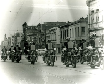
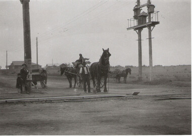
Photograph (police motorcycle)
Motorcycle police riding Ariels along tram tracks with two mounted police to the rear of the photographpolice vehicles; wireless patrol; motor transport branch; motor transport section; motor cycle patrol; police motorcycles; ariel motorcycle -
 Eltham District Historical Society Inc
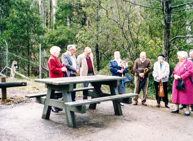
Photograph, Dedication of picnic table at Wilks Creek Bridge, Marysville by Marysville Historical Society, 13 October 1993, 13/10/1993
Wilks Creek Bridge was built in 1870. It was last used for heavy vehicle traffic in 1980 and left to decay until it was demolished in 2008. The last remnants of the timber structure were destroyed in the Black Saturday bushfire of 7 February 2009. [from EDHS Newsletter No. 93, November 1993:] OTHER NEWS A small group of members represented the Society at the opening of the picnic ground at the historic Wilks Creek Bridge at Marysville. The event included the launching of a booklet by our friend Ann Thomas on the history of the bridge which was located on the old Yarra Track coaching route between Eltham and Woods Point. Ann has donated a copy of the booklet to our Society.Two colour photographsactivities, marysville, wilks creek bridge -
 Orbost & District Historical Society
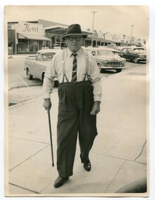
Photograph - Photograph off Albert Trewin
Albert (Abby) Trewin (b.21.03.1876 d. 01.07.1970) was part of the Trewin family who were early settlers at Jarrahmond near Orbost. Albert was born at Kingston near Ballarat, shifted to Jarrahmond where the house was called "Hillview", located 3 miles from Orbost on the B Road. The Trewin selection at Jarrahmond had many big trees on it and because these looked a bit like Jarrah trees from Western Australia, they names their property Jarrahmond (which became the district location and the name of Jarrahmond School). He cleared the land with bullocks, horses, crosscut saws, burned the stumps, burying some logs which were too big to burn. Then they milked cows, planted maize, had pigs, drove the pigs to Bairnsdale or to Waygara (c. 1915 when the train reached Waygara) on a buggy track through the bush. Pigs went to Dandenong Bacon Factory where they were processed into Dandy Ham. This photograph appears to be c.1950s - 1960s.A photograph of one of Jarrahmond's earliest settlers.B/W photograph of a man walking along a footpath. He is wearing a hat and has a walking stick in his right hand. He is wearing braces, white long-sleeved shirt, striped tie, glasses, polished black shoes. Behind him are vehicles and buildings (shops). jarrahmond, farming -
 Marysville & District Historical Society
Photograph (Item) - Black and white photograph, Yarra Track Hotel, c1900
... ), and was designed to accommodate horse-drawn vehicles. The Track involved ...An early black and white photograph of a hotel along the Yarra Track.An early black and white photograph of a hotel along the Yarra Track. The Yarra Track is the former name of the gold fields road from Healesville to the Woods Point and Jordan Goldfields, in Victoria, Australia. A direct route via the Yarra River and the Great Divide was discovered by Rieck in September 1862 and became known as the Yarra Track. Early in 1863, the Victorian Government decided to construct a 193-kilometre (120 mile) road along the route. Its original width varied between 4 and 6 metres (12 and 20 feet), and was designed to accommodate horse-drawn vehicles. The Track involved the climbing of the Black Spur, descent into the Acheron Valley, and then through Marysville to the Cumberland where it followed the existing route. Unable to ascertain both the location and name of hotel.ARMSTRONG COLLECTION 42 STATION STREET/ SANDRINGHAM 3191/ TEL. (03) 9521 5442/ IAN M.L. ARMSTRONG OAMyarra track, healesville, wood's point, jordan goldfields, victoria, yarra river, great divide, reick, black spur, acheron valley, marysville, cumberland creek -
 Marysville & District Historical Society
Photograph (Item) - Black and white photograph, The "Scandinavians' - (Deserted), c1900
... ), and was designed to accommodate horse-drawn vehicles. The Track involved ...An early black and white photograph of The Scandinavian's Hotel and Boarding House along the Yarra Track.An early black and white photograph of The Scandinavian's Hotel and Boarding House along the Yarra Track. The Yarra Track is the former name of the gold fields road from Healesville to the Woods Point and Jordan Goldfields, in Victoria, Australia. A direct route via the Yarra River and the Great Divide was discovered by Rieck in September 1862 and became known as the Yarra Track. Early in 1863, the Victorian Government decided to construct a 193-kilometre (120 mile) road along the route. Its original width varied between 4 and 6 metres (12 and 20 feet), and was designed to accommodate horse-drawn vehicles. The Track involved the climbing of the Black Spur, descent into the Acheron Valley, and then through Marysville to the Cumberland where it followed the existing route.ARMSTRONG COLLECTION 42 STATION STREET/ SANDRINGHAM 3191/ TEL. (03) 9521 5442/ IAN M.L. ARMSTRONG OAMthe scandinavians', yarra track, healesville, wood's point, jordan goldfields, victoria, yarra river, great divide, reick, black spur, acheron valley, marysville, cumberland creek -
 Marysville & District Historical Society
Photograph (Item) - Black and white photograph, Camp Opposite The "Scandinavians', c1900
... ), and was designed to accommodate horse-drawn vehicles. The Track involved ...An early black and white photograph of a camp which was opposite The Scandinavian's Hotel and Boarding House along the Yarra Track.An early black and white photograph of a camp which was opposite The Scandinavian's Hotel and Boarding House along the Yarra Track. The Yarra Track is the former name of the gold fields road from Healesville to the Woods Point and Jordan Goldfields, in Victoria, Australia. A direct route via the Yarra River and the Great Divide was discovered by Rieck in September 1862 and became known as the Yarra Track. Early in 1863, the Victorian Government decided to construct a 193-kilometre (120 mile) road along the route. Its original width varied between 4 and 6 metres (12 and 20 feet), and was designed to accommodate horse-drawn vehicles. The Track involved the climbing of the Black Spur, descent into the Acheron Valley, and then through Marysville to the Cumberland where it followed the existing route.ARMSTRONG COLLECTION 42 STATION STREET/ SANDRINGHAM 3191/ TEL. (03) 9521 5442/ IAN M.L. ARMSTRONG OAMthe scandinavians', yarra track, healesville, wood's point, jordan goldfields, victoria, yarra river, great divide, reick, black spur, acheron valley, marysville, cumberland creek -
 Marysville & District Historical Society
Document (Item) - Research Document, Judith Vimpani, William Cavanagh Farrell (1844-1901), 04-2020
... ), and was designed to accommodate horse-drawn vehicles. The Track involved ...An account of the life of William Cavanagh Farrell.An account of the life of William Cavanagh Farrell who was important to Marysville as his review in 1863 of the routes to Wood's Point led to the Yarra Track ascending the Black Spur and going on to what became the resort town of Marysville on the Steavenson River. The Yarra Track is the former name of the gold fields road from Healesville to the Woods Point and Jordan Goldfields, in Victoria, Australia. A direct route via the Yarra River and the Great Divide was discovered by Reick in September 1862 and became known as the Yarra Track. Early in 1863, the Victorian Government decided to construct a 193-kilometre (120 mile) road along the route. Its original width varied between 4 and 6 metres (12 and 20 feet), and was designed to accommodate horse-drawn vehicles. The Track involved the climbing of the Black Spur, descent into the Acheron Valley, and then through Marysville to the Cumberland where it followed the existing route.willaim cavanagh farrell, marysville, victoria, wood's point, yarra track, black spur, steavenson's creek, steavenson river, george theodore rieck -
Marysville & District Historical Society
Document (Item) - Research Document, Judith Vimpani, George Theodore Rieck (1833-pos 1884), 04-2020
... -drawn vehicles. The Track involved the climbing of the Black ...An account of the life of George Theodore Rieck.An account of the life of George Theodore Rieck. The Yarra Track is the former name of the gold fields road from Healesville to the Woods Point and Jordan Goldfields, in Victoria, Australia. A direct route via the Yarra River and the Great Divide was discovered by Rieck in September 1862 and became known as the Yarra Track. Early in 1863, the Victorian Government decided to construct a 193 kilometre (120 mile) road along the route. Its original width varied between 4 and 6 metres (12 and 20 feet), and was designed to accommodate horse-drawn vehicles. The Track involved the climbing of the Black Spur, descent into the Acheron Valley, and then through Marysville to the Cumberland where it followed the existing route.george theordore rieck, marysville, victoria, james murphy, new chum creek, wood's point, gold mining, matlock, walhalla, yarra track -
Marysville & District Historical Society
Booklet (Item) - Information booklet, Artworkz Tourism, The Big Culvert, Unknown
... vehicles. The Track involved the climbing of the Black Spur ...An information booklet that was produced as a guide to The Big Culvert.An information booklet that was produced as a guide to The Big Culvert. The Big Culvert is a historic granite and bluestone arch along the Yarra Track, a major route to Melbourne through the 1800s. Built in 1870 and a major piece of infrastructure for its time, the heritage listed culvert allowed water to flow under often-flooded the road. The Yarra Track is the former name of the gold fields road from Healesville to the Woods Point and Jordan Goldfields, in Victoria, Australia. A direct route via the Yarra River and the Great Divide was discovered by Rieck in September 1862 and became known as the Yarra Track. Early in 1863, the Victorian Government decided to construct a 193-kilometre (120 mile) road along the route. Its original width varied between 4 and 6 metres (12 and 20 feet), and was designed to accommodate horse-drawn vehicles. The Track involved the climbing of the Black Spur, descent into the Acheron Valley, and then through Marysville to the Cumberland where it followed the existing route.the big culvert, yarra track, victoria, healesville, wood's point goldfields, jordan goldfields, black spur, acheron valley, cumberland valley -
Marysville & District Historical Society
Flyer (Item) - Information flyer, Artworkz Tourism, The Big Culvert, 26-03-2016
... ), and was designed to accommodate horse-drawn vehicles. The Track involved ...An information flyer that was produced as a guide to The Big Culvert.An information flyer that was produced as a guide to The Big Culvert. The Big Culvert is a historic granite and bluestone arch along the Yarra Track, a major route to Melbourne through the 1800s. Built in 1870 and a major piece of infrastructure for its time, the heritage listed culvert allowed water to flow under often-flooded the road. The Yarra Track is the former name of the gold fields road from Healesville to the Woods Point and Jordan Goldfields, in Victoria, Australia. A direct route via the Yarra River and the Great Divide was discovered by Rieck in September 1862 and became known as the Yarra Track. Early in 1863, the Victorian Government decided to construct a 193-kilometre (120 mile) road along the route. Its original width varied between 4 and 6 metres (12 and 20 feet), and was designed to accommodate horse-drawn vehicles. The Track involved the climbing of the Black Spur, descent into the Acheron Valley, and then through Marysville to the Cumberland where it followed the existing route.the big culvert, yarra track, victoria, healesville, wood's point goldfields, jordan goldfields, black spur, acheron valley, cumberland valley -
 Marysville & District Historical Society
Photograph (Item) - Black and white photograph, Unknown
... ), and was designed to accommodate horse-drawn vehicles. The Track involved ...A black and white photograph taken at the unveiling of the sign placed at The Big Culvert.A black and white photograph taken at the unveiling of the sign placed at The Big Culvert. The Big Culvert is a historic granite and bluestone arch along the Yarra Track, a major route to Melbourne through the 1800s. Built in 1870 and a major piece of infrastructure for its time, the heritage listed culvert allowed water to flow under often-flooded the road. The Yarra Track is the former name of the gold fields road from Healesville to the Woods Point and Jordan Goldfields, in Victoria, Australia. A direct route via the Yarra River and the Great Divide was discovered by Rieck in September 1862 and became known as the Yarra Track. Early in 1863, the Victorian Government decided to construct a 193-kilometre (120 mile) road along the route. Its original width varied between 4 and 6 metres (12 and 20 feet), and was designed to accommodate horse-drawn vehicles. The Track involved the climbing of the Black Spur, descent into the Acheron Valley, and then through Marysville to the Cumberland where it followed the existing route.Unveiling of sign/ at "Big Culvert" In front Max Cockerrell and - Rear: second back Geoff Pope R.H.S. rear: Nancy "/ Anne "the big culvert, yarra track, victoria, healesville, wood's point goldfields, jordan goldfields, black spur, acheron valley, cumberland valley -
 Marysville & District Historical Society
Photograph (Item) - Colour photograph, 20-09-2008
... ), and was designed to accommodate horse-drawn vehicles. The Track involved ...A colour photograph of the entrance to The Big Culvert.A colour photograph of the entrance to The Big Culvert. The Big Culvert is a historic granite and bluestone arch along the Yarra Track, a major route to Melbourne through the 1800s. Built in 1870 and a major piece of infrastructure for its time, the heritage listed culvert allowed water to flow under often-flooded the road. The Yarra Track is the former name of the gold fields road from Healesville to the Woods Point and Jordan Goldfields, in Victoria, Australia. A direct route via the Yarra River and the Great Divide was discovered by Rieck in September 1862 and became known as the Yarra Track. Early in 1863, the Victorian Government decided to construct a 193-kilometre (120 mile) road along the route. Its original width varied between 4 and 6 metres (12 and 20 feet), and was designed to accommodate horse-drawn vehicles. The Track involved the climbing of the Black Spur, descent into the Acheron Valley, and then through Marysville to the Cumberland where it followed the existing route.the big culvert, yarra track, victoria, healesville, wood's point goldfields, jordan goldfields, black spur, acheron valley, cumberland valley -
 Federation University Historical Collection
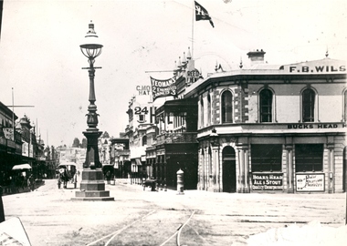
Photograph - Black and White, Bridge Street Ballarat , c1890, c1890
... , fire hydrant, Yeoman's flag, tram tracks, and horse drawn... tracks, and horse drawn vehicles. Bridge Street Ballarat , c1890 ...The original of this image is held by the State Library of Victoria.Copy of a black and white photograph of Bridge Street Ballarat from the corner of Grenville Street and Sturt Street. The photo shows a street lamp in the middle of the intersection, fire hydrant, Yeoman's flag, tram tracks, and horse drawn vehicles.bridge street ballarat, sturt street ballarat, grenville street ballarat,, f.b. wilson, buck's head hotel -
Glenelg Shire Council Cultural Collection
Photograph - Photograph - Main Breakwater construction, Portland, n.d
Port Of Portland Authority Archivesport of portland archives, main breakwater, construction, harbour development -
 City of Moorabbin Historical Society (Operating the Box Cottage Museum)
Photograph - Plateway (Wheelway) Steel, circa 1885
By the later 1800s the dirt roads in the then out-lying areas of the City of Moorabbin became dangerous, and almost impassable due to huge potholes and muddy swampy areas. The heavily laden market gardener’s carts regularly broke axles and wheels, and horses foundered on their way to the Melbourne markets. Even worse, the heavier “iron maidens”, carrying their malodorous loads of sewage from Melbourne’s inner suburbs for dumping in the outlying areas of the City of Moorabbin, also got bogged in the mire. It was decided that a practical solution to this problem was to install a metal plateway on the side of the problematic roads. In about 1887 the Moorabbin Shire Centre Road, in the Brighton East area, two parallel metal rails were installed so that the wheels of carts could run along smoothly, the horse travelled in the filled, middle area between the rails. Point Nepean Road plateway was removed in 1930 and Centre Dandenong Road plateway was removed in 1934-35. The worn plateway along Centre Road, East Brighton (now known as Bentleigh), was gradually taken up in several pieces, commencing in the the1920s, when its condition deteriorated and it caused a hazard to bikes, pedestrians, motor-cycles and the few early cars. The early steel plateway, constructed by David Munro, and opened on 23rd March 1885 by Thomas Bent, was built along Nepean Highway, between Asling St. and Bay St. The Point Nepean Track was subsequently extended into Moorabbin with branches along Centre, Cumins, South, Wickham, and Keys Roads, the total length was 13 miles. In 1908-1909 plates were laid along Centre Dandenong Road to Ross Street Bentleigh This innovative solution proved successful and was used until gradually the main roads were upgraded, and motorised vehicles started to appear. Two parallel metal rails were installed in the right hand side of a few main roads in the Shire of Moorabbin so that the wheels of heavily-loaded market gardener's carts on their way to markets in Melbourne could run along smoothly. The horse pulling the carts travelled in the filled, middle area between the rails. The Steel Plateway was constructed by David Munro, and opened on 23rd March 1885 by Thomas Bent. The wheelway first only ran along Nepean Highway, but it soon extended from Centre Dandenong Road, along Nepean road to its junction with Chapel Street, St Kilda. Later branch lines were built along Centre Road, Bentleigh as far as Warrigal Road and, according to early photographs, along Wickham Road Moorabbin as well. This innovative solution proved successful and was used until gradually the main roads were upgraded, and motorised vehicles started to appear. There was a problem with the wheelway : there was only a single set of rails and this was established on the right-hand side of the Nepean Road, travelling towards the city. Traffic FROM the city travelled on the correct or left-hand side of the road. The exception to this rule was the malodorous iron-clads, heavily riveted iron carts, generally travelling in convoy, carrying several tons of human effluent out of Melbourne to be trenched-in in the sandy soil of the Moorabbin district. Moorabbin City Council donated and installed a small section of Plateway at Box Cottage Museum in 1984melbourne, brighton, moorabbin, roads, plateway, wheelway, transport, st kilda, bent thomas, munro david, market gardens, steelway, carts horse-drawn, iron maidens, point nepean track -
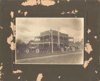 Bendigo Historical Society Inc.
Photograph - E W HANDS, BUTCHER
Black and white photograph mounted on green board. Two storey building with verandahs, iron lace, decorative curved parapet. Brick and stone building to the left. Brick house to the R. Six horse drawn vehicles at front - five decorated. Tram track across the front. Eight people on 1st floor verandah. Eight people on footpath corner. All vehicles have 2 or 3 people. Inscriptions: in image - 'Estd 1859, E W Hands, Butcher Co, Poulterer', Estd 1859 E W Hands' 'Butcher & Poulterer', 'Refrigerating Chambers on the Premises'. On front BR corner. Impressed 'W Bug, View St, Bendigo, Rosalind Studio'. On back - circular rubber stamp 'Royal Historical Society of Victoria, Bendigo Branch'. Helen Mainka 20.7.2001 '2001.187.01 taken by Ernest Bugg, Camperdown Terang'.buildings, commercial, ew hands, butcher -
National Vietnam Veterans Museum (NVVM)
Film - Film, DVD, Aussie Trackers - Vietnam - Vol. 2 (Copy 2)
Actual film footage taken by Lt. John Neervoort in Vietnam6 rar/nz, armoured vehicles, military - vietnam, military helicopters -- vietnam -
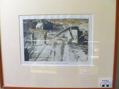 National Vietnam Veterans Museum (NVVM)
Photograph, 1970
Colour photograph of two APC's.One is on the side - damaged.Its track is lying on the sand track - Results of landmine incident.Personnel from damaged vehicle attend to necessary tasks including detecting for other mines.Tan coloured frame and cream coloured mat.Serious mine incident - Long Hais, Vietnam.1970. My Vietnam Collection. C. Bud Costello / Phil Kadow.photograph, apc -
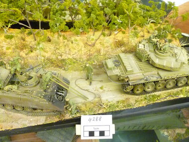 National Vietnam Veterans Museum (NVVM)
Model - Diorama, The Loss of Two Zero Alpha 1970, 2012
Depicts aftermath of mine explosion which destroyed carrier 20A of 3 Cav Regt in Feb 1970. Its driver John Graham is on a stretcher. Three vehicles are shown on a track with jungle canopy. Beside the track several personnel man the three vehicles.3 cav regt, diorama, carrier 20a, graham john -
National Vietnam Veterans Museum (NVVM)
Film - Film, DVD, Aussie Trackers - Vietnam - Vol. 2 (Copy 3)
Actual film footage taken by Lt. John Neervoort in Vietnam6 rar/nz, armoured vehicles, military - vietnam, military helicopters -- vietnam -
 National Vietnam Veterans Museum (NVVM)
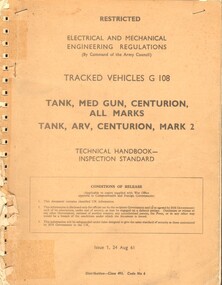
Booklet, Australian Army, Australian Army: Electrical and Mechanical Engineering Regulations: Tracked Vehicles G 108: Tank, Med Gun, Centurion, All Marks, Tank, ARV, Centurion, Mark 2
... and Mechanical Engineering Regulations: Tracked Vehicles G 108: Tank, Med ...Technical Instructions for Centurion Mark 2 TanksTechnical Booklet - inspection standardmilitary equipment, military - centurion tank -
National Vietnam Veterans Museum (NVVM)
Film - Film, DVD, Aussie Trackers - Vietnam - Vol. 2 (Copy 1)
Actual film footage taken by Lt. John Neervoort in Vietnam6 rar/nz, armoured vehicles, military - vietnam, military helicopters -- vietnam -
 Monbulk RSL Sub Branch
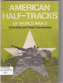
Book, Chris Ellis et al, American half tracks of world war two, 1978
... -and-the-dandenong-ranges half track vehicles - military united states army ...A detailed history of the American designed half-tracks which served the Allied nations in World War 2 and for many years after.ill (b/w), plans, p.104.non-fictionA detailed history of the American designed half-tracks which served the Allied nations in World War 2 and for many years after.half track vehicles - military, united states army - history -
 Monbulk RSL Sub Branch
Book, Squadron signal publications, German half tracks in action, 1972
... -and-the-dandenong-ranges armoured vehicles - germany half tracks - germany ...Pictorial review of the varied versions of German half tracksill (b/w) p.48.non-fictionPictorial review of the varied versions of German half tracksarmoured vehicles - germany, half tracks - germany -
 Monbulk RSL Sub Branch
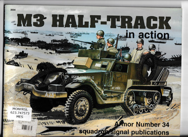
Book, Jim Mesko, M3 half track in action, 1996
A descriptive and pictorial history of the M3 half trackill (b/w,col), p.49.non-fictionA descriptive and pictorial history of the M3 half trackarmoured vehicles - united states - history, world war 1939-1945 - armoured vehicles -
 Monbulk RSL Sub Branch
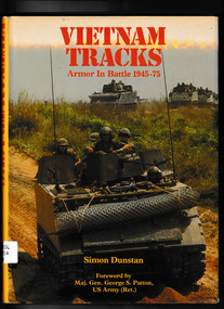
Book, Osprey Publishing, Vietnam tracks : armor in battle 1945-75, 1982
The role of armoured vehicles in the Vietnam conflictIll, maps, p.191.non-fictionThe role of armoured vehicles in the Vietnam conflictvietnam war 1961-1975 - armoured vehicles, armoured vehicles - vietnam war - history -
 Monbulk RSL Sub Branch
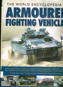
Book, Lorenz Books, The world encyclopedia of armoured fighting vehicles, 2014
... of wheeled and tracked vehicles, including AFVs from the two World ...This title examines the role of armoured vehicles, from the 1900's, the coming of age of self-propelled artillery and amphibious infantry assult vehicles in WWII, through to modern peacekeeping armoured personnel carriers. It features a range of wheeled and tracked vehicles, including AFVs from the two World Wars. Includes description and history of each vehicle, with a specification panel detailing information such as the official name, date, country of origin, crew, weight, dimensions, armament, armour thickness, powerplant, speed and range. It is a complete reference guide to over 100 years of military vehicle engineering and warfare.Index, ill, p.256.non-fictionThis title examines the role of armoured vehicles, from the 1900's, the coming of age of self-propelled artillery and amphibious infantry assult vehicles in WWII, through to modern peacekeeping armoured personnel carriers. It features a range of wheeled and tracked vehicles, including AFVs from the two World Wars. Includes description and history of each vehicle, with a specification panel detailing information such as the official name, date, country of origin, crew, weight, dimensions, armament, armour thickness, powerplant, speed and range. It is a complete reference guide to over 100 years of military vehicle engineering and warfare.armoured vehicles - history, tanks - military science -
 Bendigo Historical Society Inc.
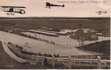
Postcard - BASIL WATSON COLLECTION: BROOKLANDS MOTOR TRACK AND FLYING GROUND
The postcard shows three planes flying above the Brooklands motor track with 'Brooklands Motor Track and Flying Ground'. To the right is a large two story brick building and on the left of the building is a long open covered vehicle stall. To the back are work sheds, further to the left are spectators cars and in the distance is open space with trees. Spectators line the race track both sides watching a racing car. In the foreground is a hill with fencing down to the track and spectators along the fence.Valentine Seriesaviation, civilian, brooklands motor track -
 Monbulk RSL Sub Branch
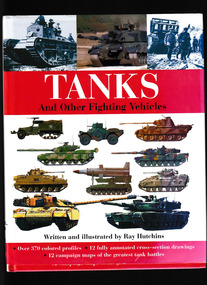
Book, Gramercy, Tanks : and other fighting vehicles, 2007
... An illustrated history of tanks and other wheeled and tracked vehicles ...An illustrated history of tanks and other wheeled and tracked vehiclesIndex, ill, maps, p.238.non-fictionAn illustrated history of tanks and other wheeled and tracked vehiclesarmoured vehicles - history, armoured warfare