Showing 2635 items
matching victoria - maps
-
 Glenelg Shire Council Cultural Collection
Map, 1885
... Map, Victoria. Skeleton map of Telegraph Circuits... telegraph railways 1885 1880s Map, Victoria. Skeleton map ...Significant collection relating to the social history across the shire.Map, Victoria. Skeleton map of Telegraph Circuits and Railways 1885. Scale 16 miles to 1 inch.map, skeleton map, telegraph, railways, 1885, 1880s -
Glenelg Shire Council Cultural Collection
Souvenir - Brochure - Promotional Material for South West Victoria, n.d
... Full colour fold-out brochure of South-West Victoria, maps... brochure of South-West Victoria, maps, photos, information. Photo ...Full colour fold-out brochure of South-West Victoria, maps, photos, information. Photo of two children, 12 Apostles in background, on front -
Tatura Irrigation & Wartime Camps Museum
Program, Goulburn Weir Rehabilitation Works Opening Ceremony
... of Victoria, map, Goulburn River system... names of Victoria, map, Goulburn River system irrigation ...Includes weir construction history, aboriginal names of Victoria, map, Goulburn River systemProgram of Opening Ceremony. White paper, black writing, blue water wheel logo in plastic sleeveirrigation, document, program, rural, industry -
 Greensborough Historical Society
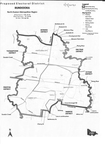
Map - Map (Copy), Electoral Boundaries Commission, Proposed electoral district: Bundoora, 01/07/2021
... - maps victoria - parliament 1p. black and white copy of map ...Proposed revised electoral boundaries for the electoral district of Bundoora (North-Eastern Metropolitan Region) as at 01/07/20211p. black and white copy of mapelectoral boundaries, bundoora - maps, victoria - parliament -
 Victorian Aboriginal Corporation for Languages
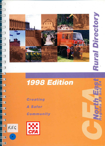
Map, Country Fire Authority, Regions 23 and 24 north east rural directory, 1998
... Victoria fire protection maps Regions 23 and 24 north east rural ...mapswodonga, albury, wangaratta, benalla, maps, victoria, fire protection -
Whitehorse Historical Society Inc.
Map, Directory Maps of the County of Bourke, 1892
... Mitcham melbourne also a complete map of the Colony of Victoria ...Directory maps of the County of Bourke, containing all the Parishes ...Directory maps of the County of Bourke, containing all the Parishes ... also a complete map of the Colony of Victoria, showing all the Counties, Parishes, Railways and stations to date, and the Mallee Blocks. Lithographed by G.S.B. Bonney for the Victorian Shire Map Company. Scale: 40 chains to the inch.Directory maps of the County of Bourke, containing all the Parishes ...maps, victoria. county of bourke, t.r.b. morton & son -
 Wodonga & District Historical Society Inc
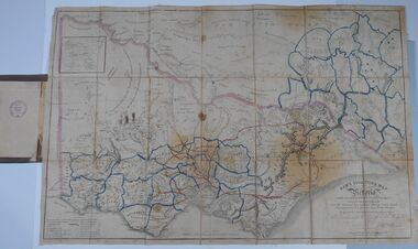
Map - Tulloch & Brown's Map of the Colony of Victoria, Tulloch & Brown, 1856
... Rare maps Victoria... maps Rare maps Victoria Victorian cartography At bottom right ...The map was created by Tulloch and Brown. David Tulloch was one of the earliest engravers and lithographers in the state of Victoria. He arrived in Melbourne from Greenock, Scotland, on 3 January 1849. Following the discovery of gold Tulloch went to the Victorian goldfields in 1851, commissioned to make sketches of the diggers and the diggings for Ham’s Illustrated Australian Magazine. In November 1852 Tulloch set up in business as engraver, draughtsman, copperplate printer and lithographer. Tulloch took a map engraver, James Davie Brown, into partnership in March 1853; the several maps and specimens of commercial engraving they showed at the 1854 Melbourne Exhibition were awarded a bronze medal. That year Tulloch and Brown also received a silver medal at the Victorian Industrial Exhibition. The partnership was dissolved towards the end of 1856.This is a very early map of the Colony of Victoria including Belvoir (now know as Wodonga).A foldable map mounted on linen and with a board cover. It records the Colony of Victoria according to Surveyor's Records revised in 1857. Areas of the map are shaded to highlight different counties.At bottom right hand section of map: Tulloch & Brown's map of the Colony of Victoria : comprising part of New South Wales, the boundaries, counties, also seaport & inland townships, the gold fields with the latest discoveries, roads, tracks, &c. &c. / compiled from drawings in the Survey Office and correctly revised till 1857. Respectfully dedicated by Permission, to the Honorable Captain Andrew Clarke R.E. Surveyor General of Victoria by His Obediant Servants Tulloch & Brown, Engravers & Publishers, Melbourne". At bottom right below border : Published as the Act directs by the Proprietors, Melbourne, 1st Feb. 1856. tulloch and brown maps, rare maps victoria, victorian cartography -
Whitehorse Historical Society Inc.
Map, Cadastral Map System, 2005
... Land Victoria map of section of Blackburn North, inc... Blackburn North Chapman Street Blackburn North Land Victoria map ...Land Victoria map of section of Blackburn North.Land Victoria map of section of Blackburn North, inc. Middleborough Road, Joseph Street and Chapman Street. Scale: 1:1500. With Lot Nos. and block frontage dimensions.Land Victoria map of section of Blackburn North. middleborough road, blackburn north, joseph street, blackburn north, chapman street, blackburn north -
Bendigo Historical Society Inc.
Map - CAMPBELL COLLECTION: BENDIGO & DISTRICT MAPS
... Commission Victoria, map N0.3, legend for roads and land and forest... inch, Forests Commission Victoria, map N0.3, legend for roads ...Map. Bendigo Whipstick, Scale 40 chains to 1 inch, Forests Commission Victoria, map N0.3, legend for roads and land and forest. (number 371 in map cupboard 1)map, bendigo, country lands -
Tatura Irrigation & Wartime Camps Museum
Book, Edward M. Curr. The Tide of History
... . Recollections of squatting in Victoria. Map of Angerang Territory..... Helliers. Recollections of squatting in Victoria. Map of Angerang ...Map of the runs of the late E. M. Curr, St. Helliers. Recollections of squatting in Victoria. Map of Angerang Territory.Front cover profile in red of E. M. Curr. Cover images. Signed by Samuel Furphy, authoredward m curr, st helliers, angerang territory -
 Bendigo Historical Society Inc.
Map - COUNTY OF GLADSTONE, November 1910
... Map: County of Gladstone, Geological survey of Victoria... Map: County of Gladstone, Geological survey of Victoria ...Map: County of Gladstone, Geological survey of Victoria. Geological mapmap, gladstone, geological, county of gladstone, geological map -
Creswick Campus Historical Collection - University of Melbourne
Map, 1937-1942
... Linen backed topographical Maps - Victoria. 26 folding maps... - Victoria. 26 folding maps School of Botany, Univerity of Melbourne ...Linen backed topographical Maps - Victoria. 26 folding mapsMapsSchool of Botany, Univerity of Melbourne -
Creswick Campus Historical Collection - University of Melbourne
Map, 1937-1942
... Linen backed topographical Maps - Victoria. 21 folding maps... - Victoria. 21 folding maps School of Botany, Univerity of Melbourne ...Linen backed topographical Maps - Victoria. 21 folding mapsMapsSchool of Botany, Univerity of Melbourne -
Yarrawonga and Mulwala Pioneer Museum
Map, Map of Victoria, 1868
... Map of Victoria...1868 Map of Victoria... of Merven Elizabeth Clarke 30 Sturt st Mulwala 1868 Map of Victoria ...Original property of Alice Rebecca Puckey [nee Ford] Born England 23/07/1867 Died rosbud Vic 16/03/1951 Grandmother of Merven Elizabeth Clarke 30 Sturt st Mulwala1868 Map of Victoria -
 Ballarat Heritage Services
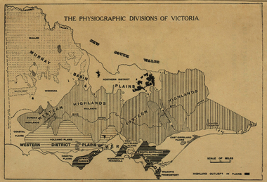
Map, Physiographic Divisions of Victoria, c1940, c1940
... Physiographic map of Victoria... Office goldfields victoria map physiography Physiographic map ...Physiographic map of Victoriavictoria, map, physiography -
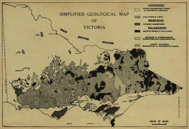 Ballarat Heritage Services
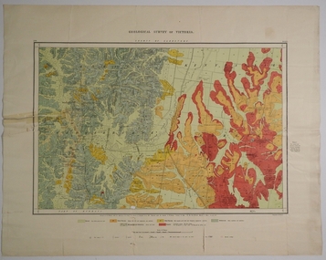
Map, Simplified Geological Map of Victoria, c1940, c1940
... Simplified Geological Map of Victoria, c1940...Physiographic map of Victoria... Office goldfields victoria map geology geological Physiographic ...Physiographic map of Victoriavictoria, map, geology, geological -
Federation University Historical Collection
Map - Plan, Ballarat Deep Leads and Mines, 1992, 1992
... Map - Gold Mines in Victoria... in Victoria. Map No.6 Ballarat Sheet 1 of 2 The map shows geology... on the bottom rhs with a map of Victoria superimposed over a poppet head... This is Bulletin No. 62: Deep Lead Gold Deposits in Victoria. Map No.6 ...This is Bulletin No. 62: Deep Lead Gold Deposits in Victoria. Map No.6 Ballarat Sheet 1 of 2 The map shows geology, topography and information on mines in the following areas: one large map of the Ballarat area with five enlargements for: Sago Hill District; Scarsdale District; Pitfield Plains District; Berringa Gold Field and Rokewood District. Ballarat Mines and Deep Leads Report No.94 (Finlay and Douglas,1992) provides a summary of the Geological Survey of Victoria mines database, references and geology for most of the mines on this map. Geology Compilation: simplified from earlier Departmental mapping with minor field checking by E.N.M. Plier-Malone. Very large rectangular sheet of paper with seven coloured maps of various sizes and a small green rectangle on the bottom rhs with a map of Victoria superimposed over a poppet head. this rectangle includes information of the other maps shown. The background for these maps is white. Also includes tables of names of mine companies, name of shafts and gold production.gold mines of australia, gold mines of victoria, gold mines- ballarat and district, gold mines pitfield plains district, gold mines scarsdale district, gold mines berringa gold field, gold mines rokewood district, gold mines sago hill district, map - gold mines, map - gold mines in victoria, ballarat, pitfield, scarsdale, berringa, rokewood, sago hill, deep lead gold deposits in victoria, geological survey - gold deposits in victoria, mining, gold deposits in victoria, gold mines in victoria, rokewook, pitfield plains -
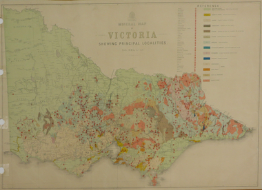 Federation University Historical Collection
Map, Department of Mines - Victoria, Geological Map of Victoria, 1936, 1936
... Geological Map of Victoria, 1936...Printed colour geological map of Victoria.... victoria geology map geological map Printed colour geological map ...Printed colour geological map of Victoria.victoria, geology, map, geological map -
Stawell Historical Society Inc
Map, Whitehead's Map of Victoria, with Alphabetical Key, 1869
... Whitehead's Map of Victoria, with Alphabetical Key...Whitehead's Map of Victoria, with Alphabetical Key... grampians Stawell Whitehead's Map of Victoria, with Alphabetical Key ...Whitehead's Map of Victoria, with Alphabetical Keystawell -
 Bendigo Historical Society Inc.
Document - HARRIS COLLECTION: HAMS SQUATTING MAP OF VICTORIA, PORT PHILLIP DISTRICT, NSW
... HARRIS COLLECTION: HAMS SQUATTING MAP OF VICTORIA, PORT... map of Victoria in 1851. The 1851 edition was accompanied... by cloth and bound. Rare, early map of Victoria and neighbouring... map of Victoria in 1851. The 1851 edition was accompanied ...Thomas Ham was a cartographer, engraver, lithographer and publisher in Victoria and Queensland. He compiled and printed several editions of his squatting map, beginning with A map of Australia Felix in 1847 and changing its title to Ham's squatting map of Victoria in 1851. The 1851 edition was accompanied by a key listing the names of all the squatters within squatting districts and counties. Later editions show the existing counties, but some areas of Gippsland and the Australian Alps are still described as 'unsurveyed country'. (State Library Victoria https://www.slv.vic.gov.au/squatting-map-victoria)Folding map enclosed in burgundy cover. Map backed by cloth and bound. Rare, early map of Victoria and neighbouring Port Phillip District of New South Wales. Written on bottom RH corner of map: Ham's Squatting Map of Victoria ( Port Phillip District, New South Wales ) carefully corrected to this date from the Colonial Government Surveys, Crown Lands, Commissioners & Explorers Maps, Private Surveys & c. Respectfully inscribed (with permission ) to His Excellency Sir Chas A. Fitz-Roy Knt, Governor of New South Wales &c &c by his Obedient Servant, The Compiler, 1851. Compiled, engraved and published by Thomas Ham, Melbourne. Proposed and original boundary ( in legend) have been coloured in in blue and pink ink ( later addition ?) Number on map show 'reference to proprietor's Printed on back of map ' J.G. AD 1852, with two cross hatched decorations and two hearts entwined. On other back panel in pencil enclosed in a drawn frame ' G.S.H., 1889, Axedale' (George Harris, Axedale, belongs in Harris Collection) Stamped in purple ink 'Royal Historical Society of Victoria, Bendigo Branch. Written 1959, 53.map, victoria, squatting map -
 NMIT (Northern Melbourne Institute of TAFE)
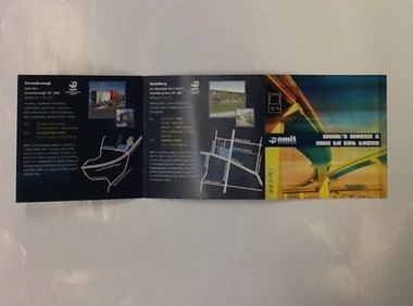
Brochure - NMIT, What's where and how to get there, 2004
... of NMIT's campuses around Victoria. Includes maps and photos of NMIT... Victoria. Includes maps and photos of NMIT campuses. nmit campuses ...This brochure lists areas of study available at each of NMIT's campuses around Victoria. Includes maps and photos of NMIT campuses.Small colour brochure, folds five pages into a square. Includes maps and photos of NMIT campuses.nmit campuses, nmit, -
Victorian Aboriginal Corporation for Languages
Book, Victorian squatters, 1983
... Detailed study of the white settlement of Victoria... of Victoria, with extensive maps and registers of early squatters ...Detailed study of the white settlement of Victoria, with extensive maps and registers of early squatters. -
Stawell Historical Society Inc
Map, Land Map of Victoria 1898, Supplement to "The Leader", 1898
... Land Map of Victoria 1898, Supplement to "The Leader"...Land Map of Victoria 1898, Supplement to "The Leader"... grampians Stawell Land Map of Victoria 1898, Supplement ...Land Map of Victoria 1898, Supplement to "The Leader"stawell -
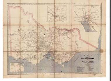 Bendigo Historical Society Inc.
Map - RAILWAYS COLLECTION: PHOTO OF RAILWAY POSTAL & TELEGRAPH MAP OF VICTORIA 1887, 1887
... MAP OF VICTORIA 1887...Railway Postal & Telegraph Map of Victoria 1887-... Map of Victoria 1887- aged map showing the various Country... PHOTOGRAPH Railway Postal & Telegraph Map of Victoria 1887 ...RAILWAYS COLLECTION- photo of Railway Postal & Telegraph Map of Victoria 1887- aged map showing the various Country Lines and insets show Melbourne and vicinity, Ballarat and vicinity and Geelong and vicinity.Picturesque Atlas Publishing Companyphotograph, railway postal & telegraph map of victoria 1887- -
Federation University Historical Collection
Plan (copy), Frederick Proeschel, Map of the Roads to all the Gold Mines in Victoria, 1853
... in Victoria. The map has been coloured to show routes to the Victorian... of the Roads to all the Gold Mines in Victoria. The map has been ...The map was pirated from Frederick Proeschel's "Pocket Map of the Roads to all the Gold Mines in Victoria" issued earlier in 1853.Digital file of the Map of the Roads to all the Gold Mines in Victoria. The map has been coloured to show routes to the Victorian goldfields from Melbourne and Geelong.frederick proeschel, proeschel, gold, mining, philp -
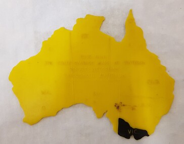 Numurkah & District Historical Society
Equipment - Plastic stencil map/shape of Austalia
... marked on the map, Victoria painted in black... in the shape of Australia, states marked on the map, Victoria painted ...Yellow plastic stencil in the shape of Australia, states marked on the map, Victoria painted in blackState Savings Bank of Victoraeducation, school, geography, australia, stencil, drawing -
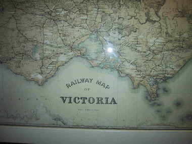 Parks Victoria - Mount Buffalo Chalet
Map, "Railway Map of Victoria"
... "Railway Map of Victoria"...Large framed map of Victoria, showing Victorias extensive...Large railway map of Victoria, Melbourne & Ballarat framed... map of Victoria, showing Victorias extensive rail network ...Large framed map of Victoria, showing Victorias extensive rail network. Printed by Victorian Railways and is one of a number of 'framed pictures, particularly photographs of scenery, which have always been a feature of the Chalet.' (Pg 83. Historica, 2011) This map has been a permanent fixture situated in the hallway alongside the ballroom leading to the ski hire area since the 1950's and most likely earlier. Listed in Draft Inventory of Significant Collection ItemsLarge railway map of Victoria, Melbourne & Ballarat framed in white painted wood. Scale eight miles to one inch. Areas of the map have been whited out.Yes -
Stawell Historical Society Inc
Photograph - Mining Scene, Close up
... Sepia Print Mining Scene, map of Victoria marking Stawell... Mining Scene, map of Victoria marking Stawell Close up Photograph ...See Holtman Panarama photo 2Sepia Print Mining Scene, map of Victoria marking Stawellmining, stawell -
Port Melbourne Historical & Preservation Society
Map, John Millar, "Design for Ship Canal or 'tidal harbor' and docks for the Port of Melbourne", 21 Sep 1860
... COPYRIGHT STATE OF VICTORIA Hydrographic map. "Design... and drainage town planning COPYRIGHT STATE OF VICTORIA Hydrographic ...COPYRIGHT STATE OF VICTORIA Hydrographic map. "Design for Ship Canal or 'tidal harbor' and docks for the Port of Melbourne". Shows proposed extension of the city westward. Signed 21.09.1860, lithographed 21.12.1860 and reproduced 1986transport - shipping, piers and wharves, engineering - canals and drainage, town planning -
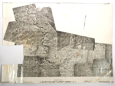 Bendigo Historical Society Inc.
Map - FRED COWIE COLLECTION: AERIAL MAPS OF HEATHCOTE/EPPALOCK
... Map, Heathcote A3, Aerial Survey of Victoria, Photo-map... of Victoria, Photo-map prepared by Department of Crown Lands.Campaspe ...Map, Heathcote A3, Aerial Survey of Victoria, Photo-map prepared by Department of Crown Lands.Campaspe River , Wild Duck Creek, Knowsley, Eppalock Weir.Fred Cowie,46 McIvor Rd ,Bendigo.map, heathcote, fred cowie