Showing 81 items
matching victorian suburbs
-
 National Wool Museum
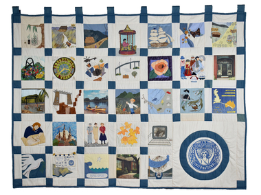
Textile - Soroptimist Project Quilt, Soroptimist International, 2000
The quilt was made by members of seventeen Soroptimist International clubs across Victoria to celebrate the Year 2000. The quilt squares illustrate some of the projects initiated, funded and supported by Victorian Soroptimists as well as illustrations of broader affiliations and responsibilities, including to the UN. Examples include the S.I.A.M. (Soroptimist International Aids Mediation) project by SI Berwick in Northern Thai villages which established industries and health programs for women and girls as viable alternatives to the sex industry. Revegetation of woodlands, wetlands and cleared land by SI Deakin. Donation of toiletries to women's shelters, police lock ups and church emergency centres in the western suburbs of Melbourne by SI Cut Paw Paw. Founded in 1921, Soroptimist International is a global volunteer movement with a network of around 72,000 club members in 121 countries. Advocating for human rights and gender equality, at the heart of Soroptimist International’s advocacy is its work across seven UN Centres, where UN representatives ensure that the voices of women and girls are heard. Memberships work on grassroots projects that help women and girls achieve their individual and collective potential, realise aspirations and have an equal voice in communities worldwide. It has a flourishing Club in Geelong. The quilt was displayed from 2001 until 2023 in Soroptimist Headquarters Victoria at 383 Toorak Road, South Yarra (Soroptimist House) since touring the State of Victoria in 2000. Soroptimist House has been sold with the funds raised to go to furthering the objectives of Soroptimism.Cream patchwork quilt with 31 squares depicting various scenes and motifs. The Soroptimist logo features in the bottom right corner.quilt, women, soroptimist, victoria, community, clubs, human rights, gender equality, united nations -
 City of Greater Bendigo - Civic Collection
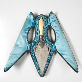
Ceremonial object - Engraved Silver Trowel, Bendigo and Eaglehawk Electric Light and Tramway Powerhouse, 1901
This trowel was presented to City of Bendigo Mayor, Simeon Ryan by Mr B. Deakin the Australian representative of the Victorian Electric Supply Company on the occasion of the laying of the foundation stone for the new power house building in Hargreaves Street, Bendigo. This power house was built to supply power to both Bendigo and Eaglehawk and the overhead power system for the tramway which ran from Quarry Hill, through the city to Eaglehawk and from Golden Square to Lake Weeroona. The building of the power house changed Eaglehawk and Bendigo as street lights were installed and houses became electrified. A report in the Bendigo Independent in 1902 reported ' Night will then be almost as brilliant as the day and people .... who live in the suburbs are to be provided with a tram service worth of the name'. (See reference A Mammoth Scheme.) The tramways closed in April 1972 after the Victorian Parliament granted the SEC an application to cease operating. Today Bendigo Trust operates the tourist trams which run along Pall Mall and welcomes over 40,000 visitors annually. The Bendigo Tramways Depot is the oldest operating tram depot in Australia and is listed on the Victorian Heritage Register. There are currently 45 trams in the fleet (13 of which operate as part of the 'Talking' Tram service).For more about the history and to tour the tramways visit www.bendigotramways.com.Triangular shaped silver engraved trowel with ivory handle (0286a). Top face of trowel is ornately engraved with floral and decorative motifs and an image of an electric tram and two power poles. Reverse has engraved text. No makers mark detected. Housed in a leather covered case (0286b), lined with ruched blue silk. Case has two brass hinges and two small brass clasps.PRESENTED / By / THE ELECTRIC SUPPLY CO / OF VICTORIA TO / SIMEON RYAN. ESQ JP. / MAYOR OF BENDIGO / ON THE OCCASION OF HIS LAYING / THE MEMORIAL STONE OF THE / BENDIGO AND EAGLEHAWK / ELECTRIC LIGHT AND TRAMWAY / POWER HOUSE / 26th JUNE, 1901/ STERLING SILVERcouncillor simeon ryan, councillor s h mc gowan, councillor john hoskins, councillor george loudon, councillor john green, councillor alfred hicks, borough of eaglehawk, borough of eaglehawk mayor, mayor loudon, city of bendigo mayor, mayor ryan, bendigo and eaglehawk tramway -
 City of Greater Bendigo - Civic Collection
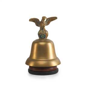
Ceremonial object - Eaglehawk Bell, unknown
The Borough of Eaglehawk was a local government area which covered the northwestern suburbs of the regional city of Bendigo and covered an area of 14.54 square kilometres (5.6 sq mi). Eaglehawk was first incorporated as a borough on 29 July 1862. It had nine councillors, who represented the entire borough. Councillors met at the Town Hall (incorporating the Star Cinema) at the intersection of Sailors Gully Road and Loddon Valley Highway, Eaglehawk. The Town hall has always been the centre of the Borough's activities and was built in 1901 on the site of an earlier town hall which had stood on the location since 1865. The Victorian Heritage Database notes: "The present building replaced this earlier building and was opened on 14 August 1901. The architects were the Melbourne firm of Wilkinson and Permewan. As a much larger and more sumptuous building of brick and stone featuring a central clock tower, the new hall reflected prevailing architectural fashion and was a remarkable investment for a town consisting predominantly of poor mining families. The condition of the town hall is substantially as built. The design is almost identical to the Castlemaine Town Hall." On 7 April 1994, the Borough of Eaglehawk was abolished, and along with the City of Bendigo, the Rural City of Marong and the Shires of Huntly and Strathfieldsaye, was merged into the newly created City of Greater Bendigo.Brass bell with eaglehawk topper / handle on timber stand. The lower front section of the topper has the Borough of Eaglehawk seal attached. No hallmarks or makers stamps visible.borough of eaglehawk, star cinema -
 Canterbury History Group
Document - Outer Eastern Suburbs Connecting Railway or Tramway, J.Kemp Government Printer, 1925
Report from the Parliamentary Standing Committee on Railways on the Outer Eastern Suburbs Connecting Railway or Tramway (Doncaster, Templestowe and Warrandyte)canterbury, doncaster, templestowe, warrandyte, victorian railways, victorian government, railways standing committee, outer circle railway, tram services -
 Ringwood and District Historical Society
Book, Elizabeth Dole Porteus, Let's Go Exploring: The Life Of Stanley D. Porteus - Hawaii's Pioneer Psychologist, 1991
White hard covered book. Biography by daughter-in-law of Stanley Porteus, pioneer of modern psychology and one-time resident of Ringwood, Victoria. SUMMARY NOTES. Stanley David Porteus was born in Box Hill, Victoria, Australia in 1883, the only son of a Methodist minister. Like other now large suburbs of Melbourne such as Canterbury, Mitcham and Ringwood, Box Hill was a mere village. Each was surrounded by bush. He grew up like most Australian boys with a love of sport and, although lightly built, did quite well at Australian Rules football and was above average at cricket. He became a schoolteacher with the Victorian Education Department. Promotion within the department depended on experience gained at teaching in tiny rural schools so he applied for such a position at Glenaladale, on the Dargo Road, some 35 miles north west of Bairnsdale. He walked about 6 miles from the nearest railway station at Fernbank to find the school surrounded by virgin forest with only one dwelling in sight. Attached to the school were lean-to rooms that were to be his residence for the next 2 ½ years. He was fascinated by the nearby Den of Nargun and Bull Creek, which joined the Mitchell River in a deep gorge containing a profusion of rainforest vegetation. While at Glenaladale, he met Frances Evans who became his wife. To seek promotion, he left Glenaladale and taught at Leneva and Benambra. While at the latter school, he learned of a position becoming available as superintendent of special schools in Melbourne. As the available means of transport, coach and horses to Bairnsdale, then by train to Melbourne, would not get him to Melbourne before the close of applications, he borrowed a bicycle and rode through the bush to his in-laws home at Lindenow and thus made it before the deadline. He was successful in his application and it set him on a course that lead to him becoming Australia's first Clinical Psychologist. His work, particularly, the development of the Porteus Maze Test, attracted the attention of American educators and he was offered an appointment for a year at Vineland Training School in New Jersey. On a stopover in Honolulu, he was impressed to the extent that he expressed a desire to work there. Not the least of its attractions was the mix of races that offered opportunities to study psychological differences, if any, between various races. His wish was to be granted unexpectedly as he was, in 1919, invited to Honolulu to set up a Psychological and Psychopathic Clinic at the University of Hawaii. From his home in the hills north of Honolulu, on December 7th 1941, he saw the Japanese attack on Pearl Harbour. He lived there until his death in about 1980. -
 Victorian Railway History Library
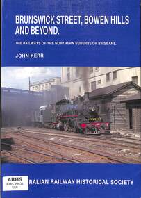
Book, Australian Railway Historical Society - Queensland Division, Brunswick Street, Bowen Hills and Beyond, 1988
A history of the railways in the northern suburbs of Brisbane in Queensland.index, ill, p.128.non-fictionA history of the railways in the northern suburbs of Brisbane in Queensland.railroad operations - queensland - history, railroad construction - queensland - history -
 Victorian Railway History Library
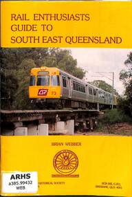
Book, Webber, Brian, Rail Enthusiasts Guide to South East Brisbane, 1994
A guide to railway locations for railway enthusiasts visiting the south eastern suburbs of Brisbane & the Gold Coast in Queensland.ill, maps, p.80.non-fictionA guide to railway locations for railway enthusiasts visiting the south eastern suburbs of Brisbane & the Gold Coast in Queensland.railroad operations - queensland - history, railroads - queensland - history -
 University of Melbourne, Burnley Campus Archives
Newspaper - Newspaper Cutting, Progress Press, Don't miss this show!, 1991
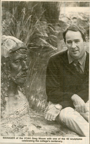
Page 3 from Progress Press (an eastern suburbs newspaper), October 2, 1991. A short article about the centenary celebrations with a photo of the principal, Dr Greg Moore sitting alongside a sculpture of a man sited in the Native Garden. The caption reads: "Manager of the VCAH Greg Moore with one of the 40 sculptures celebrating the college's centenary."dr greg moore, vcah, centenary, progress press, sculpture, principal, victorian college of agriculture and horticulture -
 Victorian Railway History Library
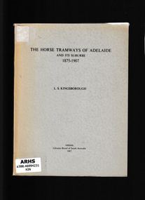
Book, Libraries Board of South Australia, The horse tramways of Adelaide and its suburbs, 1875-1907, 1965
This is a history of the Adelaide horse drawn tramways from their inception until they were taken over by the Municipal Tramways Trust. The information was gathered from various sources and that given by word of mouth has been substantiatedIll, maps, p.86.non-fictionThis is a history of the Adelaide horse drawn tramways from their inception until they were taken over by the Municipal Tramways Trust. The information was gathered from various sources and that given by word of mouth has been substantiatedtramways - australia, horse tramways - adelaide -
 Victorian Railway History Library
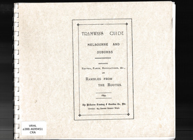
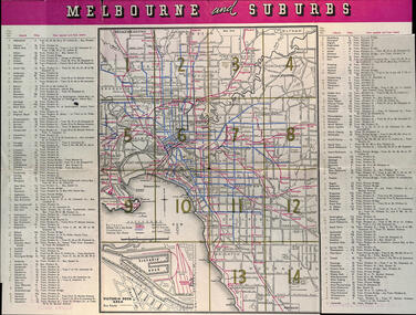
Book, Jack Cranston, Tramways guide: Melbourne and suburbs containing routes, fares, regulations and rambles from the routes, 1894
Illustrations, routes, descriptions and plans of Melbourne's cable trams 1885-1940.facsimile, Ill, maps, p.41.non-fictionIllustrations, routes, descriptions and plans of Melbourne's cable trams 1885-1940.urban transportation - melbourne, cable trams - melbourne -
 Victorian Railway History Library
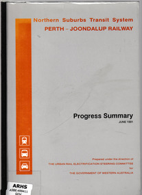
Booklet, Urban Rail Electrification Steering Committee, Northern suburbs transit system, Perth-Joondalup railway : progress summary, 1991
Progress report on the construction of the Northern suburbs transit system in PerthIll, maps, p.28.non-fictionProgress report on the construction of the Northern suburbs transit system in Perthurban transport - perth, suburban railways - perth -
 Kew Historical Society Inc
Article, The New Electric Tramway, Malvern to Kew
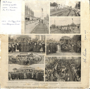
One of a group of photographs, including three within a published photo collage , taken by Edgar James Dower in the second decade of the twentieth century. Born and raised in Olinda, Dower later moved to Surrey Hills. He worked as an adult as a clerk in the city office of the Metropolitan Gas Company, and in his role as a 'collector', he was able to photograph scenes including the construction of tramlines, railways and associated buildings in Kew, Hawthorn, Camberwell and Surrey Hills. Later he established a real estate agency with his brother - the E.J. Dower Real Estate Agency, Mount Dandenong Office.The photo collage is an historically significant record of the development of transport infrastructure which was used to connect Victorians in the first two decades of the twentieth century. This development resulted from increases in population and the consequent extension of Melbourne's suburbs. The photographs, both individually and collectively, richly detail the labour of workers and the tools and machinery used to create and extend Melbourne's public transport network in the years preceding and during World War 1.Photo collage, published in The Leader newspaper in 1913, to commemorate the opening of the Malvern to Kew Tramway. The numbered photos are: 1. Kew Railway Gates at Glenferrie. 2. Burke Road Terminus. 3. Final Stages. 4. Ladies at the Official Opening. 5. The Acting Mayoress of Kew Cutting the Ribbon at the Kew Boundary. 6. Mayor and Councillors at the Kew Terminus. 7. The Cutting the First Ribbon. 8. Guests at the Hawthorn Town Hall.Inscribed in ink by Edgar J Dower top left: "The 3 top photographs were taken by E J Dower. No.3 Cotham Road Kew near Glenferrie Road"theme -- connecting victorians by transport and communications, theme -- travelling by tram -
 Melbourne Tram Museum
Map, Victorian Railways (VR), "Melbourne and Suburbs", 1956
... printed in colour "Melbourne and Suburbs" Map Victorian Railways ...Map printed by the Victorian Railways in 1955 gives places of interest, some facts about Melbourne, and amusements, with the map showing rail, tram, and railway bus routes, suburbs, golf links, sporting grounds, and municipalities. The Bourke St tram route to East Preston is shown but not the Nicholson St East Brunswick line which opened during mid 1956. Provides a detailed list of suburbs, miles from the GPO, and how reached from where. Notes it was published in Jan. 1956 by the VR Public Relations and Betterment Board.Demonstrates a Victorian Railways printed map of MelbourneMap - 8 fold printed in colourmaps, melbourne, tramways, bus routes, railways -
 Melbourne Tram Museum
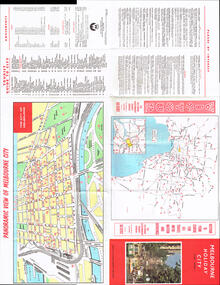
Map, Victour, "Melbourne Holiday City", c1975
Map - 12 fold special size - full colour titled "Melbourne Holiday City", published by Melbourne Tourism, c1975 prior to the construction of East Burwood tram line, providing a list of amusements, tourist locations, places of interest, map provided by Victour, The Victorian Government Tourist Bureau, a panoramic view of Melbourne and a large map of Melbourne and suburbs showing rail, bus and tram lines and key to suburbs. Cover photo with 882 (Route 11, Spencer St) in Collins St looking west with the Westgate bridge in the far background.trams, tramways, map, public transport, city of melbourne, buses, railways, tramways, victour, tram 882 -
 Melbourne Tram Museum
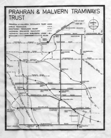
Drawing - Tramway plan, Robert Green, "Prahran and Malvern Tramways Trust", c1970
Drawing - showing the extent of the "Prahran and Malvern Tramways Trust" tramways prior to the take over by the MMTB in 1920. Shows their lines, as well as cable trams, Hawthorn Tramways Trust lines and the Victorian Railways tramways and railways. Includes depots and substations. Used in publications such as Feeding and Filling by Graeme Breydon item 1350, though slightly modified to show the curves at junctions.Yields information about the PMTT operated lines and how they served the eastern suburbs of Melbourne.Drawing - black ink on linen.Has "1/" in top left hand corner.tramways, pmtt, track plans, tram lines, htt -
 Melbourne Tram Museum
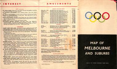
Map, Victorian Government Tourist Bureau, "Map of Melbourne and Suburbs", Jul. 1956
... - 2133-56 "Map of Melbourne and Suburbs" Map Victorian Government ...Map - .folded 12 sections full colour titled "Map of Melbourne and Suburbs". Issued at the time of the Melbourne Olympics by the Victorian Government Tourist Bureau. Has an index of Melbourne's suburbs, transport links, Places of Interest, Amusements, Facts of interest about Victoria. Major map shows the rail and tram lines, the detailed map of the CBD shows the buildings or locations referenced in the Tourist Guide to the City. Printed by the Victorian Railways - 2133-56trams, tramways, map, olympics, public transport, melbourne -
 Melbourne Tram Museum
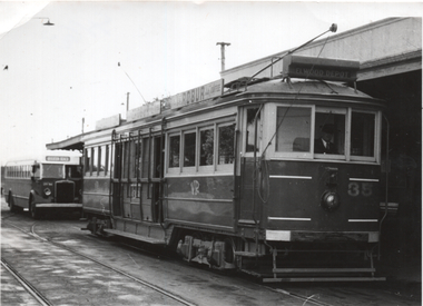
Photograph - St Kilda Station - tram 35 and half cab bus, The Age, July 1957
Photo, from The Age used in item 7194 reporting on the closure of the St Kilda - Brighton tramway from Elwood depot to Middle Brighton on 1/7/1957. Photo shows Victorian Railways tram No. 35 at St Kilda Railway station with the privately operated bus behind. The service was operated by the Eastern Suburbs Omnibus Service using some half-cab buses. The bus is a Leyland OPS4 built in 1950 and subsequently sold to Eastern Suburbs Omnibus service in 1957. Was it on hire to the Brighton bus company? Yields information about replacement of trams on the St Kilda Brighton line by buses in July 1957. Photograph - St Kilda Station - tram 35 and half cab bus - has "The Age" stamp on the rear.Has notes on rear in pencil - see context.trams, tramways, vr trams, st kilda brighton electric tramway, closure, buses, bus replacement, eastern surburbs omnibus -
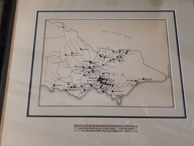 Vision Australia
Map - Object, Victorian railways map
A black and white map of Victoria showing the railway lines where mail is transported and the individual towns listed next to the dot that provides location of such. Underneath is written "Map of Victoria showing the localities beyond the suburbs of Melbourne to which library books are sent to blind members. Books are carried over the railways FREE there is no charge to the readers." Through the work of Tilly Aston, braille postage was provided free by the Victorian Railways which greatly assisted the Braille Library in reaching members who resided outside of Melbourne. This map was produced to show the extent of the work by the Victorian Association of Braille Writers and the need for reading materials across the state.Paper of Victorian railway lines mounted in framevictorian association of braille writers, marketing -
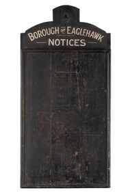 City of Greater Bendigo - Civic Collection
Sign - Borough of Eaglehawk Notices, Borough of Eaglehawk, Unknown
This notice board was used by the Borough of Eaglehawk to inform the community about services and events taking place in the local community and was hung in the Town Hall. Eaglehawk was first incorporated as a borough on 29 July 1862. It had nine councillors, who represented the entire borough. Councillors met at the Town Hall (incorporating the Star Cinema) at the intersection of Sailors Gully Road and Loddon Valley Highway, Eaglehawk. The Town hall has always been the centre of the Borough's activities and was built in 1901 on the site of an earlier town hall which had stood on the location since 1865. The Victorian Heritage Database notes: "The present building replaced this earlier building and was opened on 14 August 1901. The architects were the Melbourne firm of Wilkinson and Permewan. As a much larger and more sumptuous building of brick and stone featuring a central clock tower, the new hall reflected prevailing architectural fashion and was a remarkable investment for a town consisting predominantly of poor mining families. The condition of the town hall is substantially as built. The design is almost identical to the Castlemaine Town Hall." Eaglehawk was a local government area which covered the northwestern suburbs of the regional city of Bendigo and covered an area of 14.54 square kilometres (5.6 sq mi). On 7 April 1994, the Borough of Eaglehawk was abolished, and along with the City of Bendigo, the Rural City of Marong and the Shires of Huntly and Strathfieldsaye, was merged into the newly created City of Greater Bendigo.Handmade wooden notice board. Wood is roughly hewn and painted black with painted silver text. The front of the board is covered in pin holes. borough of eaglehawk -
 Greensborough Historical Society
Book, Making their mark: The Victorians; by Susan Priestley, 1984_
This text deals with the economic development of Victoria in the 19th and early 20th century.Published to commemorate the 150th anniversary of the European settlement of VictoriaHard cover. 382 pages, illus., maps.victoria land use, victoria economic conditions, victoria history, victoria social conditions, susan priestley, melbourne suburbs -
 Warrnambool and District Historical Society Inc.
Directory, Sands & McDougall Pty Ltd, Sands & McDougall’s Directory of Victoria and Canberra A.C.T. 1946, 1946
Sands and McDougall Pty Ltd were manufacturing stationers established in all states of Australia. In Melbourne the manufacturing business was located in Spencer Street. The company published annual directories of residents and businesses in Australia from 1857 to 1974 and these directories today are highly sought after by genealogists and researchers. This directory for 1946 came from th archives of the Warrnambool Standard newspaper. This book will be of considerable use to researchers and those wanting family information regarding Victorian and Canberra residents and their addresses in the 1940s. This is a directory of 2416 pages. The front and back covers and the spine binding are missing. The directory contains advertisements for Victorian and Canberra businesses, an index to streets in Melbourne and suburbs, an index to residents and businesses in Victoria and Canberra under suburb headings, and an alphabetical section of residents’ names.sands & mcdougall, history of warrnambool