Showing 92 items
matching visitor's map
-
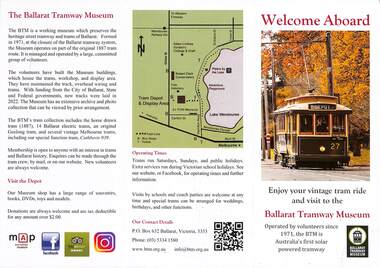 Ballarat Tramway Museum
Pamphlet, BTM Welcome Aboard 2022
Features photos of trams 27 and 1 in Wendouree Parade with an interior photo of 26 of a conductor handing out tickets. Has text describing "Your Trip", the trams, Ballarat Tramways, the museum itself along with maps of the Ballarat system and the Gardens area. Features a photo of tram 26 in the new Museum building. Text revised 2022 for the new building. See Reg. items 712, 1532, 4752 and 8061 for details of earlier productions. Item folded as presented to a passenger.Demonstrates the methodology of interpreting the tram trip for the Museum's visitors.Printed colour A4 folded sheet, 2022 version of BTM "Welcome Aboard" pamphlets for handing out to passengers on trams. Three copies held.trams, tramways, ballarat, btm, handouts, passengers, pamphlets -
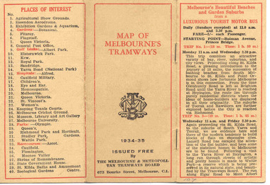 Ballarat Tramway Museum
Map, Melbourne and Metropolitan Tramways Board (MMTB), "MMTB Map of Melbourne Tramways 1934-5", 1934
Demonstrates methods of giving information to visitors to Melbourne and yields information about tram services at the time in Melbourne.Very small pocket sized timetable and map book, consisting of 2 octavo cards stapled and folded into 12 pages consisting of three pages of bus and tram round trips, 3 center pages for map of electric and cable trams, route numbers and interest points. Map printed in 4 colours. 4 pages index to routes and first and last trams to City and from City. Also gives points where suburban routes are intersected by City routes. One page devoted to places of interest. All printing in black with red headings and highlights.trams, tramways, mmtb map, mmtb, timetables, tourist trips, map -
 Ballarat Tramway Museum
Document - Guide Book/notes, Tramway Museum Society of Victoria (TMSV), "Guide for Delegates interested in trams", 1970
Demonstrates notes prepared by the TMSV for tours of the Ballarat and Melbourne systems and the nature of the notes.Five page spirit duplicated notes to act as a guide to visitors to the International Convention of Railway Modellers, Melb. 1970. Index, history of TMSV, map of Malvern depot, model trams, exhibition notes, place of Melb. Tram interest, notes and map on Ballaarat. Missing is pages 6, 7, and 8 - noted in index on page 1. Pdf image of document added 31/10/2013.trams, tramways, melbourne, ballarat, tmsv, model tramways -
 Stawell Historical Society Inc
Book, Stawell & Grampians Tourist Council, Stawell & Grampians Visitor Guide & Directory 1979, 1979
Tourist Guide to Stawell and the GrampiansBlue cover with red, yellow & blue print. Picture of the Grampians in center of cover.In Red Print Stawell and Grampians. In Yellow Print Visitor Guide and Directory. In Blue Print 4th Edition Souvenir Edition. In White Inset "Containing Offical Walking Maps. Bottom Right in Yellow Print " Issued by the Stawell and Grampians Tourist and Promotion Advisory Council. In two white circle with white and Red print the Price in Red "Recommended $1.00 Price" Bottom Right at 45 degrees in blue print Concession Coupons Inside.stawell tourism -
 Stawell Historical Society Inc
Book, Stawell & Grampians Tourist Council, Stawell & Grampians Visitor Guide & Directory 1981, 1981
Tourist Guide to Stawell and The GrampiansGreen paper cover with Red, Yellow & White Print. Centre of page is a colour photo of the Grampians. Red Test. "Stawell and Grampians" inside white triangle "Stawell & Grampians Promotion". Yellow Print Tourist Guide" Inside a white segmented circle, white Print "5th Editon $1" Inside Yellow outlined rectangle with yellow Print. "Contains: WHAT TO SEE & DO REFERENCE MAPS NOTES ON 5 TOURS 28 GRAMPIANS WALKS 9 SPECIAL FEATURE ATICLES ACOMMODATION & BUSINESS GUIDEstawell tourism -
 Falls Creek Historical Society
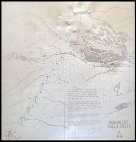
Map - Sun Valley, Falls Creek, 1966
This hand drawn map shows the Gully Chair, Summit Tow and the Village Tow. It also highlights the Nursery Poma. Several buildings can be seen along with the Visitor Centre in the Gully carpark, Skyline can can be seen adjacent to the Gully Chair. The Sun Valley T-Bar was designed by Ron McCallum and began operation in 1967. It had a length of 826 metres and an elevation of approximately 200 metres. In 1989 the Sun Valley T-Bar was replaced by the Scott Quad. Ron McCallum was a founder of Alpine Developments. It appears that his first lift was the Skyline portable tow at Falls Creek in 1954. As an engineer, he went on to build about 20 chairlifts and T-bars in the 1960s and early 1970s including at least five at Falls Creek. This map is significant because it shows plans for the development of a major tow at Falls Creek in the 1960s.A framed black and white concept map for the proposed new lift in Sun Valley, Falls Creek.sun valley tow, ron mccallum, falls creek tows -
 City of Greater Bendigo - Civic Collection
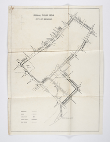
Document - Set of correspondence re Queen Elizabeth tour of Bendigo, Mrs T. R. Mannix, February 8th, 1954
Correspondence between Mrs T. R. Mannix, Swan Hill Wolf Cub Pack master to District Scout Commissioner Mr J. I. Samson for an invitation to be included with the local scout groups in functions to welcome Queen Elizabeth and the Duke of Edinburgh to Bendigo on Friday, the 5th of March 1954. The response from the Commissioner included typed plans of the event and maps of the royal tour through the streets of Bendigo starting and finishing at the train station.Set of correspondence including typed gatefold letter, typed plans for placement of visitors and role of the military and maps of CBD Bendigo and of Upper Reserve.queen elizabeth, duke of edinburgh, boy scout association, mayor clayton, city of greater bendigo royal visits, city of greater bendigo community groups, city of greater bendigo tourism -
 Mont De Lancey
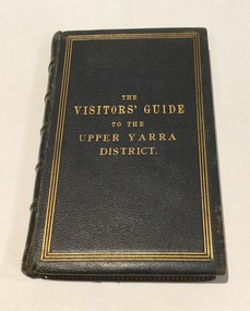
Book, The visitors' guide to the Upper Yarra District
Presented to the Wandin Historical Society by Mrs. Noel Rowe (nee Massina), 1992. Restored by Apollo Moon.Navy hard covered book with gold embossing of title and decorative border. Includes maps and blank pages. Has marbled end papers.upper yarra, yarra river -
 Phillip Island Conservation Society Inc.
Work on paper - Photocopy of newspaper cutting, "PHILLIP ISLAND/A place to fall in love"
This article was written by an English visitor named Elsa Christian who was touring Australia and New Zealand with her husband Frank in their own small van. The article was published in the Australian Women’s Weekly, magazine, March 1966. Elsa writes she wanted to visit four Australian locations before she died: Ayers Rock (actually Uluru), the Snowy River project, dolphins at Coolangatta and the Penguin Parade at Phillip Island. These destinations were all very popular in the 1960s for both Australian residents and overseas visitors. Because the roads were becoming better too many locations, self guided tours in small vans for cars towing bond would caravans were becoming more popular means of seeing AustraliaThe article is significant in many ways. 1. Indicates the places English visitors commonly wish to see in Australia. 2. Describes the growing trend to self- drive van/camping holidays. 3. Gives the route taken from Melbourne to Phillip Island during the 1960s. 4. Describes the appearance of the roadsides and locations visited. 5. It is written in a descriptive and lyrical style designed to appeal to Women’s Weekly magazine readers, who were probably wondering how they could visit Phillip Island with their husbands or families themselves, and what there was to see there. 6. Gives the visitors’ view of how the Penguin Parade operated at the time. 7. Includes a description of potter and artist Eric Juckert’s renowned garden at Grossard Point, Ventnor. 8. Indicates how introduced plants such as Hawthorn pushes and Kate weed were common in the area. 9. Describes Phillip Island as “a place to fall in love” because of its natural beauty, fauna and coastal seascapes. 10. As a visitor Elsa describes the housing estates as a blot on the landscape, but also sees the value as a way of their owners escaping from the hustle and bustle of Melbourne. 11. Gives the visitors’ interpretation of the behaviour of wildlife the RC in the wild, as well as Elsa’s knowledge about some of the species she encounters.Photocopy of full page article with 5 columns of text, a map and 2 photographs. Black ink on white paper. Photographs blackened in photocopying processphillip island, cape woolamai, penguin parade, seal rocks, nobbies, township of rhyll phillip island, princes highway, dandenong, pakenham, kooweerup, carinya creek, officer, san remo, gippsland highway, holiday homes, fort dumaresq, kitty miller's beach, wreck of the speke, hereford cattle, fleetwood manor, koalas, ventnor, eric juckert, little penguin behaviour -
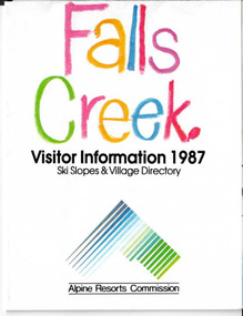 Falls Creek Historical Society
Booklet - Brochure - Falls Creek Visitor Information 1987
... including images, text and maps, Brochure - Falls Creek Visitor ...Part of an annual marketing campaign, this booklet was designed to provide information for planning a holiday at Falls Creek for the winter of 1987. It includes extensive details about activities, facilities and accommodation in the Village as well as contact information to make necessary bookings.This item is important because it documents seasonal activities at Falls Creek Alpine ResortFold out information guide for Falls Creek winter holidays 1987 including images, text and maps,falls creek marketing, falls creek winter programs, falls creek village -
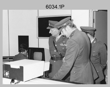 Bendigo Military Museum
Photograph - Visit by the Chief of the General Staff to the Army Survey Regiment, Fortuna, Bendigo, 1979
This is a set of 14 photographs of a visit to the Army Survey Regiment, Fortuna, Bendigo on the 5th of June 1979 by the Chief of the General Staff (CGS) Lieutenant General Sir Donald Dunstan AC, KBE, CB. He was accompanied by his wife. They were escorted through the production areas of the Army Survey Regiment by the CO LTCOL Bob Skitch. Lieutenant General Sir Donald Dunstan AC, KBE, CB was an esteemed Australian Army officer, who was CGS from 1977 to 1982. Upon retirement from the Army in 1982, he was appointed to the position of Governor of South Australia from 1982 to 1991. LTCOL Bob Skitch was the CO of the Army Svy Rgt from 1976 to 1980. Also featuring in these photos is MAJ Peter Eddy, who was the OC of Air Survey Squadron. He was later promoted to LTCOL and was CO of the Army Svy Rgt from 1981 to 1982. See item 6035.9P for photos of the CGS’s presentation of the Defence Force Service Medal to four recipients.This is a set of 14 photographs of a visit by the Chief of the General Staff to the Army Survey Regiment Fortuna, Bendigo on the 5th of June 1979. The photographs were printed on photographic paper and are part of the Army Survey Regiment’s Collection. They were scanned at 300 dpi. .1) - Photo, black and white, 1979. Tour of Air Survey Squadron. L to R: unidentified, LTGEN General Sir Donald Dunstan AC, KBE, CB; OC MAJ Peter Eddy, unidentified. .2) - Photo, black and white, 1979. Tour of Air Survey Squadron. LTGEN General Sir Donald Dunstan AC, KBE, CB; views 3D stereoscopic aerial photography on a Zeiss (Jena) Stecometer. OC MAJ Peter Eddy is on his right. .3) - Photo, black and white, 1979. Tour of Air Survey Squadron. L to R: unidentified, CO LTCOL Bob Skitch, OC MAJ Peter Eddy, LTGEN General Sir Donald Dunstan AC, KBE CB viewing an aerial photograph. WO1 Brian Mead and others are operating a Wild PUG4 point transfer device. .4) - Photo, black and white, 1979. Enlargement of photo .3). Tour of Air Survey Squadron. L to R: unidentified, CO LTCOL Bob Skitch, OC MAJ Peter Eddy, LTGEN General Sir Donald Dunstan AC, KBE CB viewing an aerial photograph. .5) - Photo, black and white, 1979. Tour of Air Survey Squadron. LTGEN General Sir Donald Dunstan AC, KBE, CB; and unidentified technician view 3D stereoscopic aerial photography on a Wild B8 stereo plotter. .6) - Photo, black and white, 1979. Tour of Air Survey Squadron. L to R: OC MAJ Peter Eddy LTGEN General Sir Donald Dunstan AC, KBE CB; CO LTCOL Bob Skitch, view the output of a verification plot on an AUTOMAP 1 Gerber 1442 drum plotter. .7) - Photo, black and white, 1979. Tour of Air Survey Squadron. L to R: CO LTCOL Bob Skitch, unidentified aide de camp officer, LTGEN General Sir Donald Dunstan AC, KBE CB; OC MAJ Peter Eddy discuss aero triangulation planning documents. CAPT Don Maskew in background. .8) - Photo, black and white, 1979. Tour of Cartographic Squadron. L to R: CPL Dennis Learmonth, acting OC CAPT Bob Roche, CAPT Eddy Schulze, LTGEN General Sir Donald Dunstan AC, KBE CB; SSGT John ‘JB’ Barrie discuss cartographic map compilation procedures .9) - Photo, black and white, 1979. Tour of Cartographic Squadron. L to R: Tech WO WO1 Roger Rix, acting OC CAPT Bob Roche, CAPT Eddy Schulze, unidentified visitor, Mrs Dunstan with examples of map products. .10) - Photo, black and white, 1979. Tour of Cartographic Squadron. L to R: CPL Terry Danger, CO LTCOL Bob Skitch, LTGEN General Sir Donald Dunstan AC, KBE CB; discuss terrain embossing (hill shading) procedures. .11) - Photo, black and white, 1979. Tour of Cartographic Squadron. L to R: CO LTCOL Bob Skitch, LTGEN General Sir Donald Dunstan AC, KBE CB; acting OC CAPT Bob Roche, SSGT Dick Manley, CAPT Don Maskew and CAPT Steve Cooper in background. SPR Cheryl Lofthouse is retouching blemishes on a map separation film negative. .12) - Photo, black and white, 1979. Tour of Lithographic Squadron. L to R: CAPT Stan Vote, unidentified aide de camp officer, CO LTCOL Bob Skitch, LTGEN General Sir Donald Dunstan AC, KBE CB; MAJ Sam Schwartz EXCH-US, LT John Harrison discuss bulk map printing processes with an Ultra-MAN-III Printing Press. .13) - Photo, black and white, 1979. Officers Mess L to R: LTGEN General Sir Donald Dunstan AC, KBE CB; with CO LTCOL Bob Skitch. .14) - Photo, black and white, 1979. Officers Mess L to R: MAJ Peter Eddy, LTGEN General Sir Donald Dunstan AC, KBE CB..1P to .14P – no annotationsroyal australian survey corps, rasvy, army survey regiment, army svy regt, fortuna, asr -
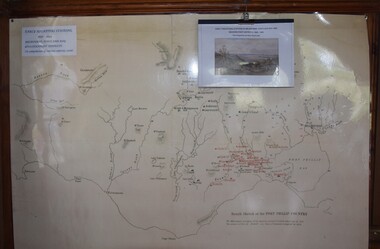 Buninyong Visitor Information Centre
Map, Early Squatters Stations 1837-1838
The map shows rivers and pastoral holdings from 1837 to 1838. Stations occupied around Geelong in 1837 are shown in red and those occupied in 1838 are shown in black. Reproduction of a coloured map shows pastoral stations around the Geelong area from 1837-1940. pastoralism, stations, farming, settlement, squatters -
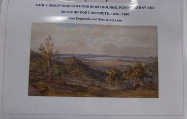 Buninyong Visitor Information Centre
Booklet - Index to Map, Early Squatters' Stations in Melbourne, Portland Bay and Western Port Districts, 1836-1840
Photocopied copy of an index.Horizontally bound A4 typed listing with coloured illustration on the front page and a clear plastic cover sheet.non-fictionPhotocopied copy of an index.settlers, farming, pastoralism -
 Buninyong Visitor Information Centre
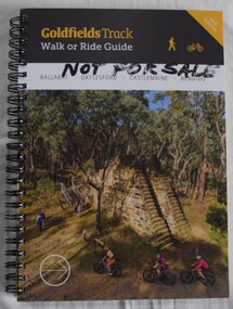
Book, Gib Wettenhall, Goldfields Track: Walk or Ride Guide. 2nd Edition, 12.2017
The guide was written by Gib Wettenhall in collaboration with the Great Dividing Trail Association and Goldfields Tracks Inc. The book gives detailed information about the track including historical notes, maps and numerous photographs. Members of the Buninyong Visitor Centre and the local community actively supported the extension of the Great Dividing Trail from Ballarat through to Buninyong. Spiral bound book with photograph on cover showing mining works and tourists visiting. Title is on a black section. 'Not for Sale' handwritten in Texta on the cover.great dividing trail, goldfields, cycling, walking, tracks -
 Buninyong Visitor Information Centre
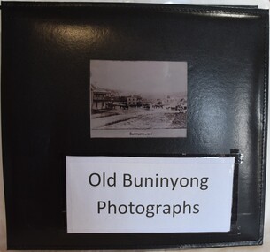
Album - Photograph Album, Old Buninyong Photographs (Early Buninyong)
The album was compiled by Derek Leather using photographic reproductions of images of Buninyong. The album includes early maps, streetscapes, monuments and buildings.Significant images of nineteenth century Buninyong streetscapes.Black, hard-covered album with thirty-two fixed photographs and five lose photographs. Compiled by Derek Leather, former Shire of Buninyong councillor. Old Buninyong Photographsbuninyong, derek leather, streetscapes -
 Warrnambool and District Historical Society Inc.
Booklet - Warrnambool Visitor's Handbooks 1979-2024, Collett, Bain and Gaspar, Printers, 1979-2014
This is a collection of eight Warrnambool Visitor handbooks produced between 1979 and 2014 by the City of Warrnambool Tourist Information Centre. They contain maps of Warrnambool, lists of services, accommodation and tourist attractions as well as many advertisements for local businesses.These handbooks give a useful snapshot of businesses and tourist attractions in Warrnambool for each of the years covered. (1979, 1980, 1986, 1990, 1993, 1994, 1995, 2014)[.1a] A 48 page booklet with white pages and blue printing. The front cover has a coloured photograph of Flagstaff Hill with boats on a man made lake in the foreground looking across Lake Pertobe toward South Warrnambool. [.1b] A coloured bifold brochure. The front cover has a fisherman on a cray-boat holding a crayfish in the lower section. The top quarter has a blue back ground with white printing. The rear cover is red and has small photos of the Hopkins River and the Framlingham Forest. [.2] A 48 page booklet with white pages and black printing. The front cover is white with black writing on the left hand side and a colour photograph of the Loch Ard peacock. The Warrnambool Premier Town stylised logo of seven Norfollk pines above blue waves is in the top right hand corner. There is a blank ink Warrnambool Library stamp underneath the logo. The rear cover has photographs of The Twelve Apostles and the Hopkins Falls and the Premier Town Logo [.3] A 40 page booklet with mainly black printing on white paper. There are three fold out maps of Warrnambool and the surrounding district. The glossy cover has a black background with a colour photograph of the Twelve Apostles taken at sunset. The rear cover has three small of Proudfoot's boathouse on the Hopkins River, Flagstaff Hill, and the main beach area. The front cover has black writing inside to peach coloured rectangles. The inside rear cover has a fold out coloured tour map of Western Victoria. [.4] A 40 page booklet printed on glossy white paper with coloured photographs and black and red printing. The front cover has a photograph of The Twelve Apostles surrounded by a white border. There is red writing in the upper border. There is a sandy coloured writing superimposed across the bottom of the photograph and a Victoria's Shipwreck Coast logo in the bottom right hand corner. [.5] A 44 page booklet printed on white paper with black printing. The cream coloured cover has a pale red rectangle with blue writing on the right hand facing edge and includes two stylised Norfolk pines and with waves underneath. There is is an intersecting blue rectangle with cream printing. [.6] A 48 page booklet printed on white paper with black printing. The cover is brown with a cream vertical strip containing black writing on the right hand side. There is a stylised map from Geelong to Mount Gambier showing the Great Ocean Road across the cover. [.7] A 48 page booklet printed on white paper with black print. The glossy colour cover has a photograph of a Southern Right whale fluke. There is white printing on a the blue background of the sky and sea. The bottom left hand side of the front cover has a Tourism Victoria logo made of jigsaw puzzle pieces. The back cover has a stylised coloured map of The Great Ocean Road located in a white rectangle at the top of the page. Within the rectangle is a small map of Australia locating Victoria and the part of Victoria covered by the map. [.8] A 64 page A5 coloured booklet printed on white pages with black print. The white front cover has black and grey print with a colour photograph of two people holding coffee cups watching four race horses being exercised on the beach and in the water of Lady Bay in the early morning. The bottom right hand corner has a Tourism Victoria logo. The rear cover has a mainly blue back ground with a pink orange and green colour splats contains words advertising the 2015 Fun 4 Kids Festival [.1a] Warrnambool The Heart of Victoria's Great Southwest Visitor's Handbook [.1b] Warrnambool City for all seasons; The Heart of Victoria's Great Southwest [.2] Warrnambool visitor's handbook Warrnambool Premier Town 1979-1982 [.3] Warrnambool Handbook Victoria [.4] Warrnambool The Shipwreck Coast [.5] Welcome to Warrnambool Warrnambool Visitors Handbook 1993-1994 [.6] Welcome to Warrnambool Visitors Handbook 1994-95 Rear cover: Warrnambool Centre of Victoria's Shipwreck Coast on Australia's Great Ocean Road [.7] Warrnambool Shipwreck Coast - Great Ocean Road; You'll love every piece of Victoria; Visitors Handbook [.8] Warrnambool Great Ocean Road Official Visitor Guide; It's a wonderful Warrnambool; You'll love every piece of Victoria visitvictoria.com. Rear Cover Live entertainment.Workshops.Creativity.Action 28 June - 5 July 2015 Australia's Best Children's Festival F4K The ultimate winter school holiday adventure Fun 4 kids festival Warrnambool For more information visit Fun4kids.com.au Warrnambool great Ocean Road Victoriawarrnambool, visitor handbooks, tourist information guides, warrnambool maps -
 Bendigo Historical Society Inc.
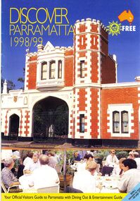
Book - STRAUCH COLLECTION: DISCOVER PARRAMATTA
BHS CollectionDiscover Parramatta 1998/99 your official visitors guide to Parramatta with dining out & entertainment guide with photographs and a map.australia, history, parramatta, australia - history - nsw - parramatta -
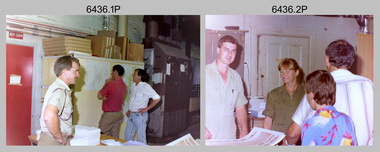
 Bendigo Military Museum
Photograph - Army Survey Regiment Open Day - Map Production, Fortuna, Bendigo, 1990
These 35 photographs were taken at an Army Survey Regiment Open Day at Fortuna Villa, Bendigo on the 24th of February 1990. This occasion was one of several events held to commemorate the 75th anniversary of the formation of the Royal Australian Survey Corps. Although historical tours of Fortuna occurred on a regular basis, this was the first technical open day since 1972. The Royal Australian Survey Corps recognised that an Open Day was the best way for the local community in Bendigo to gain an insight into the unit’s important role as Defence’s map production agency, its technical equipment, and its economic importance to Bendigo. It also gave them an opportunity to tour through historic Fortuna Villa. This occasion is covered in more detail in page 143 of Valerie Lovejoy’s book 'Mapmakers of Fortuna – A history of the Army Survey Regiment’ ISBN: 0-646-42120-4. Refer to items 6434.27P and 6436.18P for more photos of the Open Day taken inside Fortuna, the garden areas and production areas of Lithographic Squadron. Photo prints of some of these photos were scanned and catalogued in items 6247.30P and 6291.6P.These 35 photographs were taken at an Army Survey Regiment Open Day held at Fortuna, Bendigo on the 24th of February 1990. The 35mm colour and black & white negatives photographs were scanned at 96 dpi and are part of the Army Survey Regiment’s Collection. .1) - Photo, black & white, 1990. CPL Neale ‘Tex’ Houston with visitors in Aerotriangulation Section. .2) - Photo, black & white, 1990. L to R: MAJ Peter Clark and WO2 Neil ‘Ned’ Kelly with visitors in Aerotriangulation Section. .3) - Photo, black & white, 1990. SGT Bruce Hammond with visitors in Aerotriangulation Section. .4) - Photo, colour, 1990. SGT Bruce Hammond with visitors in Aerotriangulation Section. .5) - Photo, colour, 1990. SGT Steve Gloster with visitors in Aerotriangulation Section. .6) - Photo, colour, 1990. L to R: CPL Noel Brinsmead and CPL Darren Wilkinson with visitors in Aerotriangulation Section. .7) - Photo, colour, 1990. L to R: CPL Noel Brinsmead with visitors in Aerotriangulation Section. .8) - Photo, colour, 1990. MAJ Peter Clark with visitors in Aerotriangulation Section. .9) - Photo, colour, 1990. CPL Mark Lander with visitors in Plotting Section. .10) - Photo, colour, 1990. SSGT Andy Boath with visitors in Plotting Section. .11) - Photo, colour, 1990. SPR Stuart Bowd with visitors in Plotting Section. .12) - Photo, colour, 1990. CAPT Roger Hancock with visitors in Plotting Section. .13) & .14) - Photo, colour, 1990. AUTOMAP 2 - CPL Peter Peterson with visitors. .15) - Photo, colour, 1990, AUTOMAP 2 - L to R: SSGT Graham Johnston, SPR Grant Davis with civilian visitors. .16) - Photo, colour, 1990, AUTOMAP 2 - L to R: CPL Steve McGuiness, SSGT Graham Johnston with civilian visitors. .17) - Photo, colour, 1990, AUTOMAP 2 - civilian visitors. .19) - Photo, colour, 1990, AUTOMAP 2 - L to R: unidentified, SPR Tony Jackson, CPL Mark Westbrook, SSGT Bob Bright, with civilian visitors. .20) - Photo, colour, 1990, AUTOMAP 2 - L to R: WO2 Adrian ‘Charlie’ Creedy, CPL Mark Westbrook, SPR Mick Duggan with civilian visitors. .21) - Photo, colour, 1990, AUTOMAP 2 - L to R: SPR Mick Duggan, CO LTCOM Rene van den Tol, SSGT Bob Bright, CPL Mark Westbrook with civilian visitors. .22) - Photo, colour, 1990, AUTOMAP 2 - L to R: SPR Damien Nolan, unidentified, SPR Peter Smyth with civilian visitors. .23) - Photo, black & white, 1990, AUTOMAP 2 - L to R: SPR Peter Smyth, CAPT Steve Hledik, SGT Martin Evans, MAJ Neil Taylor with civilian visitors. .24) - Photo, black & white, 1990, AUTOMAP 2 - L to R: SPR Mick Duggan, CPL Mark Westbrook with civilian visitors. .25) - Photo, black & white, 1990, AUTOMAP 2 – LCPL Sandy Winn with civilian visitor. .26) - Photo, black & white, 1990. Display of digital storage media. .27) & .28) - Photo, colour, 1990. Cartography - SPR Ian Baldwin with civilian visitors. .29) - Photo, black & white, 1990. Cartography - SPR Ian Baldwin with civilian visitors. .30) - Photo, black & white, 1990. Cartography - SGT Sherri (Dally) Burke with civilian visitors. .31) - Photo, colour, 1990. Cartography - L to R: SGT Sherri (Dally) Burke, SSGT Dennis Learmonth with civilian visitors. .32) - Photo, colour, 1990. Cartography – SGT Barry Hogan with civilian visitors. .33) & .34) - Photo, colour, 1990. Cartography – CPL Dan Cirsky with civilian visitors. .35) - Photo, colour, 1990. Cartography – L to R: SPR Jeanette (Lane) Dury-Lane, CPL Diane (Thomas) Soutar with civilian visitors..1P to .35P – no annotationsroyal australian survey corps, rasvy, army survey regiment, army svy regt, fortuna, asr, automap 2 -
 Bendigo Military Museum
Photograph - Army Survey Regiment Open Day – Lithographic Squadron, Fortuna, Bendigo, 1990
These 18 photographs were taken at an Army Survey Regiment Open Day at Fortuna Villa, Bendigo on the 24th of February 1990. This occasion was one of several events held to commemorate the 75th anniversary of the formation of the Royal Australian Survey Corps. Although historical tours of Fortuna occurred on a regular basis, this was the first technical open day since 1972. The Royal Australian Survey Corps recognised that an Open Day was the best way for the local community in Bendigo to gain an insight into the unit’s important role as Defence’s map production agency, its technical equipment, and its economic importance to Bendigo. It also gave them an opportunity to tour through historic Fortuna Villa. This occasion is covered in more detail in page 143 of Valerie Lovejoy’s book 'Mapmakers of Fortuna – A history of the Army Survey Regiment’ ISBN: 0-646-42120-4. Refer to items 6434.27P and 6435.35P for more photos of the Open Day taken inside Fortuna, the garden areas and Map Production areas of Air Survey and Cartographic Squadron. Photo prints of some of these photos were scanned and catalogued in items 6247.30P and 6291.6P.These 18 photographs were taken at an Army Survey Regiment Open Day held at Fortuna, Bendigo on the 24th of February 1990. The 35mm colour and black & white negatives photographs were scanned at 96 dpi and are part of the Army Survey Regiment’s Collection. .1) - Photo, colour, 1990. Print Troop – WO2 Rob Bogumil with visitors. .2) - Photo, colour, 1990. Print Troop – L to R: SPR Ross Anza, LCPL Janet Murray with visitors. .3) - Photo, black & white, 1990. Print Troop – L to R: LCPL Janet Murray, MAJ Bob Coote, SPR Gary Lord with visitors. .4) - Photo, black & white, 1990. Photo Troop – L to R: WO2 Keith Fenton RE UK Exchange, SGT Steve Burke with visitors. .5) - Photo, colour, 1990. Photo Troop – SGT Steve Burke with visitors. .6) - Photo, colour, 1990. Photo Troop – L to R: unidentified, SGT Steve Burke with visitors. .7) - Photo, colour, 1990. Print Troop – L to R: CPL Peter Breukel, WO2 Keith Fenton RE. UK Exchange with visitors. .8) - Photo, black & white, 1990. Photo Troop - WO2 Keith Fenton RE. UK Exchange. .9) - Photo, black & white, 1990. Print Troop - civilian visitors. .10) - black & white, Print Troop, 1990. - L to R: civilian visitors, SSGT Ian Nichols, CPL John ‘Flash’ Anderson. .11) - Photo, black & white, 1990. Print Troop - L to R: SSGT Ian Nichols, CPL Dale Hudson, Planeta printing press, with civilian visitors. .12) - Photo, colour, 1990. Print Troop - L to R: SSGT Ian Nichols, CAPT Roger Hancock with civilian visitors. .13) - Photo, colour, 1990. Print Troop - LT Marty Lyons with civilian visitors. .14) - Photo, black & white, 1990. Print Troop - L to R: LT Marty Lyons, unidentified with civilian visitors. .15) - Photo, black & white, 1990. Orthophoto Mapping Section - L to R: SSGT Peter Imeson, SGT Bob Garritty with civilian visitors. .16) - Photo, colour, 1990. Optronics raster scanner - WO2 Adrian ‘Charlie’ Creedy with civilian visitors. .17) - Photo, colour 1990. Outside Photo Troop office - L to R: SSGT Rhys De Laine, WO2 Rob Bogumil. .18) - Photo, black & white, 1990. Photo Troop - civilian visitors..1P to .18P – no annotationsroyal australian survey corps, rasvy, army survey regiment, army svy regt, fortuna, asr, litho sqn -
 Falls Creek Historical Society
Flyer - Falls Creek Visitors Information 1992 & 1994
... Creek Falls Creek Trail maps Falls Creek Visitor Information Two ...These publications were developed by the Falls Creek Ski Lifts Pty. Ltd. to promote activities and facilities at Falls Creek for the Winter Seasons of 1992 and 1994. They include maps of Falls Creek Village and the surrounding slopes as well as pricing for ski lifts and packages. Advertisements for Frying Pan Inn and Cloud 9 Restaurant are featured.These items are important because they document seasonal activities at Falls Creek Alpine Resort over time.Two glossy coloured flyers featuring images and information about skiing and trails at Falls Creek. Prices for different lift passes, ski gear rental and season passes are included.falls creek marketing, ski packages falls creek, falls creek trail maps, falls creek visitor information -
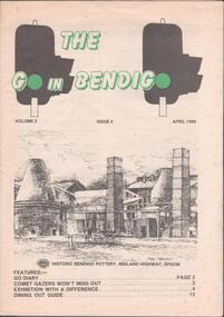 Bendigo Historical Society Inc.
Magazine - THE GO IN BENDIGO - MAGAZINE, April 1986
Magazine - 16 page guide for visitors and residents of Bendigo. Vol.2, Issue 4, April 1986. Includes tourist attractions, wineries, dining out, with a map on the back page. Sketch of the Bendigo Pottery by Stan Thomas on front cover. Editor Barry McNaught. Publisher not mentioned. bendigo attractions, bendigo pottery, stan thomas, barry mcnaught, rosalind park, gail tavener, arakoon resort -
 Warrnambool and District Historical Society Inc.
Booklet - Booklet Collection: City of Warrnambool Tourist Guides, Collett, Bain and Gaspar, Warrnambool
This is a collection of sixteen tourist guides dating from the mid 1970's to 2013. These contain listings of businesses, accommodation, eateries and events in Warrnambool and district. They also include maps of Warrnambool and surrounds, advertising and photographs of various attractions. While mainly covering Warrnambool a small number of the guides cover the South West Region. These directories have mainly been published by the Warrnambool City Council and are a selection of the types of information provided to visitors at the Tourist information centre during this time period.These tourist guides give snapshots of the City of Warrnambool for the years covered and will be useful for research.[.1] An 8 page paper booklet with black printing and a black & white photo of the pond at the Botanical Gardens on the front cover. [.2] two photocopied A4 black and white pages from the book "On the Trail" K Winser 1956 (Main Roads of Australia) [.3] A trifold colour brochure with a stylised map of the coast on the yellow and blue front cover. The inside has stylised colour drawings on Warrnambool attractions. The rear cover has coloured photographs of bush, Liebig Street and Fletcher Jones gardens [.4] A trifold black and white brochure with a black line drawing of a whale on the front cover. [.5] A trifold white card with mauve printing. The front cover has a line drawing of the former Timor Street post office and a map of businesses and landmarks in Timor Street. The reverse side contains a brief history of Warrnambool. [.6] A 98 page stapled booklet with a foreword by Vanda Savill. There are 4 pages of coloured photographs. The remainder are black and white photographs. The front cover is purple with white writing in the lower third. There is an outline of the coast and five colour photographs of district attractions. The inside middle page has a map of the Western wonderland region. The content covers towns in this area. Content relating to Warrnambool is in the last six pages. [.7] Twelve loose photocopied black and white pages. The front cover has the Warrnambool Premier Town 1988-1991 logo and a photo of a Southern Right Whale and calf. The bottom right hand corner has a Standard Warrnambool logo. [.8] 44 page booklet printed with blue ink. The staples have been removed. The glossy front cover has blue printing with a coloured photo of Flagstaff Hill Maritime Village pond. The centre pages has a fold out map of the City of Warrnambool. The rear cover has photos of The Twelve Apostles and Hopkins Falls. [.9] 4 loose photocopied pages with Warrnambool Library and Corangamite Regional Library Service Warrnambool City Library black ink stamps. The front page line drawing illustrations of Warrnambool attractions [.10] A single sheet of glossy white paper folded in half to make four pages. The front page has a Warrnambool premier town logo 1979-1982 and blue printing and a visitor survey. [.11] A conference pack of light card folded to make a pocket containing three brochures, a shipwreck coast tourist directory and a Australian Heritage Parks Association conference program dated 24 to 27 May 1992. The front cover of the pack has green writing over a stylised upward arrow. There is a City of Warrnambool logo in the top right hand corner and two film strips diagonally across the cover containing photographs of Warrnambool. The rear cover has a coloured Warrnambool Premier Town logo. [.12] A 63 page stapled booklet with coloured photographs of Warrnambool. The front cover has black writing on white background. There is a coloured photograph of Flagstaff Hill in the middle of the cover and a Warrnambool City and Visit Victoria logos on the lower edge. The middle pages has a coloured of the city of Warrnambool with an inset map of Allansford. [.13] A single large sheet of white paper folded in ten to make a brochure. The front cover has black printing. The rear cover has a purple ink stamp for the City of Warrnambool Tourist Information Centre. When folded out the reverse side has a green, grey and white map of the South West Region of Victoria. [.14] A 48 page colour booklet on glossy paper. The front cover has white writing on a blue background and includes photographs of the Twelve Apostles, the Promenade walk, Flagstaff Hill and a southern right whale's tail. The rear cover has photographs of The Twelve apostles, a passenger train from Melbourne passing the Lake Pertobe playground, and a rural scene. There is white writing and a white Warrnambool City logo on a blue background. The centre pages have a stylised green and blue map of the city of Warrnambool. [.15] A 48 page colour booklet on glossy paper. The front cover has white writing over colour photographs of two people at a lookout, Flagstaff Hill, three southern right whales and a child at the Lake Pertobe playground. The lower edge has blue upper case writing on a white background. The rear cover has a colour photograph of the Twelve Apostles. The lower white border on the rear covers has a a blue and green City of Warrnambool logo and blue writing. The centre pages have a stylised green and blue map of the city of Warrnambool. [.16] A 64 page colour booklet on glossy paper. The front cover has black writing on a black background and there is a photograph of a southern right whale's tail. The lower edge has the Warrnambool City and Visit Victoria Logos. The centre pages have maps of Warrnambool and surrounds. [.1] This week in Warrnambool Vol 2 No. 5 Thurs 1st Feb. For the time of your life [.2] Warrnambool Way [.3] Warrnambool The Holiday Host on the South West Coast with compliments City of Warrnambool and Warrnambool Chamber of Commerce [.4] MMI Insurance presents Whales Giants of the Deep Whale Watcher's Logbook Warrnambool [.5] Warrnambool History began in Timor Street [.6] Western Wonderland Tourist Association [.7] A Premier Arrow Tour of Warrnambool Victoria's Premier Town Australia's Southern Right Whale Nursery [.8] Warrnambool The Heart of Victoria's Great Southwest Visitor's Handbook [.9] What to see in Warrnambool Victoria's Premier City 1979-1982 [.10] Win a Free Holiday & $200 Cash in Victoria's Premier Town [.11] Advancing Warrnambool together! [.12] Great Ocean Road Warrnambool Official Visitor Guide [.13] Tourist guide to the South West Region Victoria All it needs is you [.14] Warrnambool visitor guide 2005 the great ocean road experience attractions accommodation entertainment dining [.15] Warrnambool Visitor Guide 2006 the great ocean road experience Attractions Accommodation Entertainment Dining [.16] Official Visitors' Guide Warrnambool Victoria Australia Discover the Great Ocean Road warrnambool, warrnambool tourist guides -
 Melbourne Tram Museum
Pamphlet, Department of Infrastructure (DOI), "Melbourne's Free City Circle Tram", 2005
Pamphlet - folded to DL size, 8 fold, titled "Melbourne's Free City Circle Tram" and on rear "Official Visitors Guide to Melbourne". Details the City Circle tram, c2005 - has route via Harbour Esplanade - map shows various points, the Golden Mile heritage walk. Has the Victoria government, City of Melbourne and Yarra Trams logos. Provides information on the points of interest and the Visitor Centre. Gives a short history of Melbourne's tram and has a photo of V214 See Reg Items 1199, 866 and 2993 for other versions.trams, tramways, city circle, yarra trams, docklands, tram 856, tram 888, tram 214, tram 3004 -
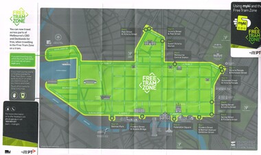 Melbourne Tram Museum
Map, Public Transport Victoria (PTV), "Using myki and the Free Tram Zone", 2015
Folded paper map with glued card in two of the corners to give the document some strength or usability (24 folds), titled "Using myki and the Free Tram Zone" details the extent of the free tram zone or showing the tram lines that the free travel is allowed, locations, land marks, contact numbers and has the PTV logo in the top right hand corner and the Myki logos. The reverse details how the Myki system works, the various types of tickets, how to buy, visitor packs and using and managing Myki tickets.trams, tramways, yarra trams, ptv, maps, free tram, melbourne, myki -
 Melbourne Tram Museum
Pamphlet, Public Transport Victoria (PTV), "City Circle", 2019
3 fold, DL pamphlet for Melbourne visitors & tourists describing the city circle tram. Provides running times with map showing various Melbourne tourist attractions.trams, tramways, city circle, melbourne, passengers, tourist guides, route 35 -
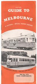 Melbourne Tram Museum
Pamphlet, J B Publications, "Visitors Guide to Melbourne", May. 1974
Pamphlet - 28 pages, centre stapled titled "Visitors Guide to Melbourne", dated 20 May 1974. Has on front cover trams W7 1032 and PCC 1041 with the caption "Melbourne's Trams - the old and the new" Has many advertisements, a small map, places of interest including Sovereign Hill, Leonda, driving in central Melbourne and wearing of seat belts. Has photo looking north along Swanston St - see image 2. Welcome by Minister for Tourism Murray Byrne.trams, tramways, melbourne, visitors, guides, w7 class, 1041, tram 1032, tram 1041 -
 Melbourne Tram Museum
Map, The Met, "Melbourne City Guide", March 1991
Map issued by The Met, March 1991 based on a Melway map of the Central city area providing details of tram, bus and trains, attractions, major institutions, tourism information, and dining out areas or streets. Demonstrates a map produced by The Met to assist Melbourne visitors.Map - 14 fold printed on gloss paper.trams, tramways, the met, maps, melbourne, cbd -
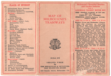 Melbourne Tram Museum
Map, Melbourne & Metropolitan Tramways Board (MMTB), "Map of Melbourne Tramways", 1934
Map booklet consists of three pages of bus and tram round trips, 3 center pages for a map of electric and cable trams, route numbers, and points of interest. Has 4 pages giving an index to routes and first and last trams to and from the City. Shows points where suburban routes are intersected by City routes. One page of places of interest. Dated 1934/35.Demonstrates methods of giving information to visitors to Melbourne and yields information about tram services at the time in Melbourne.Map - 2 octavo cards stapled and folded into 12 pages. All printing is in black with red headings and highlights except for the map which is in four colours.tramways, trams, mmtb, map, timetables, tourist trips -
 Melbourne Tram Museum
Pamphlet, Public Transport Corporation (PTC), "Free City Circle Tram", mid 1990's
Pamphlet - eight fold to DL size, full colour, titled "Free City Circle Tram" with a photo of a City Circle tram passing Flinders St station. Has information about Melbourne trams, the Melbourne Town Hall, Visitor Information, Walking Trails, a map of the route, with places of interest shown. Map shows the service via Spencer St. Has photos of 2013 and 909 as well. Has the City of Melbourne, Department of Infrastructure and Public Transport Corporation logos. Possible produced during the mid 1990's given the various logos used. .1 - As above, but with Yarra Trams and State Government logos See Reg Items 1387 and 2703 for other versions.trams, tramways, city circle, melbourne, public transport corporation, ptc -
 Bendigo Historical Society Inc.
Document - VICTORIA HILL - VISITOR PLANS FOR VICTORIA HILL
Handwritten carbon copy and typed copy of notes on 1st and 2nd stage plans for a tourist area on approx. 20 acres at Victoria Hill. First stage was to clean up the area, locate and sign post shafts, engine beds, etc and prepare a topographical map with these features on it. Second stage was to arrange for the purchase of typical miners homes and shops in the vicinity to be restored for inspection by visitors. Mining equipment to be placed in the area. Prepare brochures for sale. Set up a mining museum.Prepare an area near BCV 8 with direction finder to mining and general features, as this has the best natural ground level view in the City. Notes prepared by Albert Richardson.mine, gold, victoria hill, victoria hill, visitor plans for victoria hill, darrel mcclure, bendigo city council, bendigo historical society, central nell gwynne, caleb thomas, bcv 8, lazarus, old chum, new chum, victoria, repeater station (p. m. g.)