Showing 124 items
matching water mill
-
 Bendigo Historical Society Inc.
Newspaper - JENNY FOLEY COLLECTION: LOOP-PILE
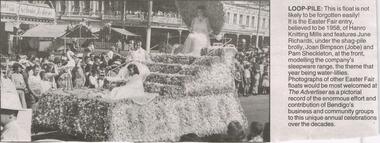
Bendigo Advertiser "The way we were" from Friday, May 28, 2004. Loop-pile: this float is not likely to be forgotten easily! It is the Easter Fair entry believed to be 1958 of Hanro Knitting Mills and features June Richards, under the shag-pile brolly, Joan Simpson (Jobe) and Pam Sheckelton at the front, modelling the company's sleepwear range, the theme that year being water-lilies.newspaper, bendigo advertiser, the way we were -
 Bendigo Historical Society Inc.
Newspaper - AILEEN AND JOHN ELLISON COLLECTION: BENDIGO ADVERTISER FRIDAY, APRIL 10, 1964
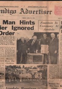
Bendigo advertiser from Friday, April 10, 1964. On the front page two photos and an article 'Axedale receives piped water after 19 year struggle' one photo shows the State opposition leader Mr. Stoneham operating a drinking fountain at the opening of the Axedale water reticulation system. At right the Minister for water supply Mr. Mibus. Others in the picture are: from left Councillors T. H. Grigg and J. Mills of Strathfieldsaye Shire and Mr. L. J. Ellison chairman of the Axedale Water trust. The other photo show Minister Mibus meeting with local children.newspaper, bendigo advertiser, axedale -
 Bendigo Historical Society Inc.
Newspaper - LONG GULLY HISTORY GROUP COLLECTION: THE MINE FLOODING CRISIS - VICTORIA QUARTZ
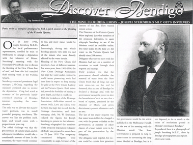
Copy of an article in the Bendigo Weekly titled The Mine Flooding Crisis - Joseph Sternberg MLC gets involved by James Lerk. Joseph Sternberg MLC travelled to Melbourne to arrange a deputation with the Minister of Mines to discuss the flooding of the New Chum line of reef. Pumping was mentioned but it would be expensive and would take time and the water would keep rising. They would also have to find a suitable pumping plant. The New Chum Drainage Association had kept the water under control. Delegates wanted the Government to subsidise the removal of the water.bendigo, history, long gully history group, the long gully history group - bendigo weekly, james lerk, victoria quartz, joseph sternberg, the honorable p mcbride, j h craig, new chum reef, new chum drainage association, new chum railway, mills lavis and elliot, mr w sparkman, melbourne herald, alan spicer -
 Bendigo Historical Society Inc.
Tool - MERCURY BUCKET
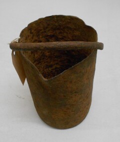
Cast iron mercury bucket, used to hold mercury, potentially in the process of recovering minute pieces of gold mixed in soil and sediments. See research page for description of one process of using mercury to extract gold.gold mines, mining equipment, mercury bucket, miners used mercury in a number of ways to amalgamate gold, with each mill or battery operator having their preferred method depending on the nature of the ore. by the late 1850s the most common way of crushing goldbearing quartz ores or consolidated alluvial cements was in a stamp battery. the battery featured heavy iron stamp heads held in a frame, with each head often weighing up to 500 pounds (226 kg) or more (see msv 1880, page 45) (birrell 2005). stamp heads were lifted and dropped by a rotating overhead cam shaft driven by a steam engine or water wheel. ore was fed into a large cast-iron battery box, mixed with a steady stream of water, and pulverised by the stamp heads. in some batteries, mercury was placed in the base of the boxes to amalgamate with freed gold. the violent agitation of the mercury in the mortar box, however, could cause the mercury to break into myriad tiny globules that were carried away by the water with the tailings, thus losing a certain amount of gold in the process (thompson 1867; ritchie & hooker 1997). the water and sand slurry was splashed by the falling stamps from the box through fine mesh screens and onto inclined wooden tables below the mortar box (figure 2). the tables were covered with copper sheets or plates coated with mercury, which caught and amalgamated with a portion of the gold. the grey putty-like amalgam was periodically scraped off the sheets and retorted in a furnace to collect the gold and recover the mercury for reuse. mercury was inevitably lost from the plates, while poor maintenance resulted in further losses of gold and mercury in the tailings. mercury use and loss from gold mining in 19th century victoria. peter davies1, susan lawrence, and jodi turnbull, department of archaeology and history, la trobe university. -
 Bendigo Historical Society Inc.
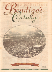
Newspaper - LONG GULLY HISTORY GROUP COLLECTION: BENDIGO'S CENTURY VOLUME THREE: 1920 - 1929
Newspaper supplement titled Bendigo's Century Volume Three: 1920 - 1929. Front page has a photo of The Duke and Duchess of York visit to Bendigo, 1927. Each year has heading of Who's Who, Weather, Sport and Business. First years are 1910 - 1919 titled The way we were. 1920 is titled Prince hailed. 1921 - City racks up a milestone. 1922 - Furore erupts. 1923 - Felons escape from city gaol. 1924 - Bid to finish RSL memorial. 1925 - Foul odour over sewerage plan. 1926 - Lest we forget Bendigo's fallen. 1927 - Royal Visit captures city. 1928 - Four shot in farm tragedy. 1929 - Billie's trip to remember.bendigo, history, long gully history group, the long gully history group - bendigo's century - volume three: 1920 - 1929, bendigo advertiser, duke and duchess of york, cr e m vains, r putnam, a j taylor, j h jackson, w crowley, sandhurst football club, george lansell, st peter's church, bendigo junior technical school, prince of wales, unity mine, mr w wilson, badak tin mining syndicate, mr t w ortonmr h scarborough, mr raleigh, general sir w r birdwood, the soldiers' memorial committee, bendigo city council, rsl memorial hall, captain g c wilson, lietenant r j parer, lieutenant j c mcintosh, cr j p carolin, h k morris, e a morris, turf tavern hotel, rev donald baker, all saints' pro--cathedral, keck's nursery, bendigo amalgamated goldfields, rising sun hotel, leanne mcdonnell, most rev john mccarthy, sir john quick, prime minister billy hughes, state rivers and water supply commission, diptheria, edna stevens, bendigo railway workshops, watson sustenance fund, sir joseph cook, dr lanza, bendigo amalgamated goldfields, bendigo benevolent asylum, miner's phthisis, bendigo gas company, electric light company, bendigo sewerage authority, commonwealth bank, cr curnow, the earl of stradbroke, dame nellie melba, princess theatre, lt-col g hurry, h sw lawson, countess of stradbroke, clunes woollen mills, girton college, mrs polglaise, mrs kennedy, gold discovery memorial, cr m g giudice, victorian co-operative freezing company, bendigo brick and tile company, mr lawson, soldiers' memorial, windermere hotel, toni riley pharmacy, bendigo gaol, mr a a dunstan mla, new red white and blue mine, claude de vere, walter osborne, sir john and lady quick, jonathan smalley, bendigo advertiser, st paul's bells, mr t cambridge, epsom public hall, bendigo school of mines, major lansell, mr h s w lawson, cr david andrew, colonel hurry, mr s bruce, bendigo sewerage authority, eppalock weir scheme, bendigo football league, r s l memorial, major g v lansell, lempriere, mr s m bruce, sandhurst hotel, market square, big hill tunnel, bendigo football league, bendigo united cricket club, south bendigo rex, sacred heart cathedral, hercules mine, gillies, aids & appliance shop, anne caudle centre, fizelle & mulqueen, south new moon mine, bendigo sewerage authority, mr a a kelley, epsom sewerage works, white hills botanical gardens, mr j sternberg mlc, bendigo book of remembrance, bendigo football league, senator general drake-brockman, captain dyett, school of mines, handschin and romus, hanro (aust.) bendigo knitting mills, charles handschin, farmers' union, andrew sunstan mla, country progressive party, john allan, captain g j c dyett, eahlehawk ufs dispensary, data fundamentals, the duke and duchess of york, the hercules mine, cr j a michelsen, lansell family, bendigo agricultural society, huntly shire council, bendigo creek trust, south african war memorial, cr j h curnow, st paul's church of england diamond jubilee, bendigo chamber of commerce, bendigo freezing works, bendigo pottery, bendigo trotting club, new red white and blue mine, the conservatory, cr e g batchelder, hercules mine, billie rigby, bendigo railway station, travellers' aid society, eppalock weir, the state rivers and water supply commission, bendigo railway workshops, frank grove, cr curnow, electric supply company, state electricity commission, australian aero club, bendigo preserving company, jardine, busbridge, feeman, mr h pearce, bfl, fred wood -
 Melbourne Water
Transparency, Staff and Chauffeurs at the O'Shannassy Weir Quarters, 8th April, 1921
The O'Shannassy Weir was a small Weir created in 1911 and completed in 1913, and was the originating point of outflow into the Aqueduct. In 1928, it was replaced by the much larger O'Shannassy Reservoir. The Weir had water moving along the Aqueduct to the Surrey Hills Reservoir. Many structures at the Weir precinct have survived and remain in-situ.The O'shannassy Weir and Aqueduct contains a wide range of intact and diverse features. This demonstrates the way in which the Board constructed and managed the water supply that flowed through farmland and forest areas subject to timber milling. The caretakers residences that are located along the aqueduct were utilised by caretakers who were responsible for maintaining one of their four sections of the channel. This transparency is significant for its historic association to the establishment of the weir and to those who worked on the project, and at the quarters. weir, o'shannassy, aqueduct, reservoir, melbourne water, mmbw, staff -
 Bendigo Historical Society Inc.
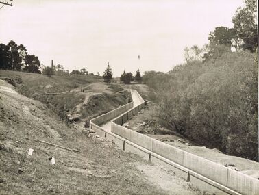
Photograph - JOSEPH BRADY COLLECTION: FLUMING BETWEEN MALMSBURY RESERVOIR AND CALDER HIGHWAY, 1934
Black and white photograph: image shows concrete channel snaking down hill, top LH side appears to be bluestone mill with tall chimney. Trees on RH side of channel. Comments on the back of the photo 'Between Malmsbury Res and Calder Hwy. 8 feet wide 4 foot 6 inches deep. Taken 1934. JA 10/81 concrete grand fluming at 12.5 miles Main channel 8 feet wide 4 foot 6 inches high. Constructed 1928.'place, water, coliban race, john brady collection. coliban race -
 Bendigo Historical Society Inc.
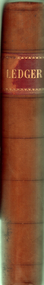
Book - BUSH COLLECTION : LEDGER BOOK 1888 TO 1920
... Water and Kerang Roller Mill Coy... Contract West Z West H M Water and Kerang Roller Mill Coy Yeates ...a. Book with a mottled blue-grey cover with brown leather spine and extends 5.5 cm to front and back. Corner edges also had the leather, two are missing and the other two are dilapidated. A red stuck on tape near the top of the spine had Ledger printed with some gold edging, most of which is worn off. Inside the front and back covers is a red, blue and white marble pattern. Front and back covers have been reinforced with white tape. 542 page Ledger Book for a general produce merchant. Probably Albert Bush. Alphabetical index at front. Entries in black ink on all pages and date from 1888 to 1920. Loose 4 page foolscap inside front cover listing Rolling Stock and Value. b. A pocket in the back of the book contains 6 pieces of paper relating to business and finance. Items include Discounts and Commission from 1888 to 1899, a note on insurance, a note dated June 2/90 headed Mr A Bush Sandhurst Dr to S A Bush & Co listing monthly amounts of money from Jan 1890 and 1889. Some amounts are with the name G P Reddie.Another one is a Building A/C dated 1889. Another is a balance sheet written on a page with another one written on the back and dated 1893. One written on paper headed Bush's Stores, Main Street, Bairnsdale and printed S.A.Bush & Co. It looks like a list of repayments listed in 8 bills. The other side of the page refers to Bill of Sales for Yeates & Baker and Bill of Sales held by the Bank of New South Wales. There is also a copy of two letters addressed to A Bush, one dated Oct 17.06 from H Hopkins referring to the late Mr Baker's property in Sale. The other is addressed to A Bush Esq and signed Harry Hopkins and also signed by Albert Bush and dated Nov 28 1906 in reference to the sale of a property.business, retail, bushs, bush collection - ledger book 1888 to 1920, abbott & co, allcock ?, australian producers & traders ltd, bush s a, bush albert, broome sp, brealey w h, blogg bros, b'daledistrict farmers co-op coy ltd, bush and hopkins, berry henry, brockhoff & co, bush mrs albert, colonial bank, corden i s & co, crosby h m, cannon j e, dudgeon and arnell, drevermann & coy, fry bros, felton grimwade & coy, fyansford maunfacturing coy, gearing jas, hawthorn rhodes & coy, henebery john, harper r & co, holford's contract, jack a & co, kellie wm, kitchen & co, kronheimer & co, miller d, lewis & whitty, levy bros and coy, melbourne chilled butter coy, mooney i, mitchell & coy, mann mrs, mceacharn & son, macrobertson, mckenzie i & co, parsons bros & coy ltd, peterson & coy, phoenix biscuit coy, reddie g p estate, ross bros, gippsland news, rosella preserving coy, rolfe and coy, robur tea coy, ross, ryan w, russo and santamria, sniders i ? b, swallow and ariell ltd, sutherland john, service & co jas, smallman mrs, thomas w c, sandhurst & n d trustees coy, voght george, victoria soap & candle coy, vogt k, vickers and gardner's contract, west z, west h m, water and kerang roller mill coy, yeates and watson, yeates and baker, yates and c ? arthur, yeates jas -
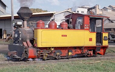 Puffing Billy Railway
Tank Locomotive, 0-6-2 T No.1 "Delta", 1950
0-6-2 Tank Locomotive No.1 "Delta" Gauge 2'0" Identification: 1 Delta Type: 0-6-2T Builder: Perry Engineering, Mile End, South Australia Builder's number: Perry 7967.50.4 of 1950 Building date: 1950 Current status - Static Exhibit Wheel Arrangement 0-6-2T Cylinders (Diameter X Stroke) 10 inches X 18 inches Boiler Pressure 180 psi Driving Wheel (Dia.) 28 ½ inches Weight 16 tons Coal Capacity 27 cubic feet Water Capacity 500 gallons The Perry Engineering Co, Mile End, South Australia built a total of 18 locomotives for the 2’0” gauge tramways used by the sugar industry in Queensland. This 0-6-2T locomotive was built by Perry Engineering Co. Ltd. of Mile End, Adelaide as their Builder's No. 7967.50.4 of 1950. It was used at Qanaba Mill, Bundaberg where it was known as No.1 "Delta". / Qanaba Mill No.1 No. 1 “DELTA” 0-6-2 TANK LOCOMOTIVE Gauge: 2 foot Built by Perry Engineering Company of South Australia in 1950 (Builder’s number 7967.50.4), “DELTA” is a medium sized Australian designed locomotive featuring Walschaert’s valve gear driving piston valves. Weighing 16 tons (16.3 tonnes) it was one of the post-war narrow gauge steam locomotives, which worked in the canefields of Queensland until 1978. “DELTA” worked at various sugar mills in the Bundaberg area and was finally withdrawn from service at Quanba Mill after a life of 28 years. Obtained by the Puffing Billy Preservation Society in 1981. Delivered to Australian Estates Co., Kalamia Mill named DELTA in 1950. Purchased by Fairymead Mill as No 20 DELTA. Purchased by Millaquin Sugar for Qanaba Mill as No. 1 DELTA, 1970 Withdrawn from service, 1978. Obtained by Puffing Billy Preservation Society for display at the Puffing Billy Museum.Historic - Industrial Narrow Gauge Railway - Steam Locomotive used in Queensland in Sugar Mill service. Locomotive No.1 "Delta" - Steam Locomotive - made of steel, and wrought ironDelta0-6-2 tank locomotive no.1 "delta" perry engineering - puffing billy railway perry 7967.50.4 of 1950, puffing billy, qunaba sugar mill, bundaberg, perry engineering, delta, steam locomotive, 0-6-2 tank locomotive no.1 -
 Clunes Museum
Photograph - PHOTOGRAPHS, INTERKNIT KNITTING MILL
.1 TANKS AT REAR OF FACTORY TO FILTER AND PURIFY WATER .2 MR. F. ANNEAR OPERATING A LARGE PLANT OF HOSIERY MACHINES .3 SOUTH CLUNES SCHOOLinterknit, tanks, machinery, south clunes school, mr f annear -
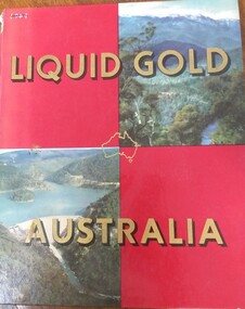 Tatura Irrigation & Wartime Camps Museum
Book, Clive Turnbull, Liquid Gold Australia, 1960
The story of the most fertile regions of the Victoria: the Goulburn Valley and North Eastern Victoria, the adjoining territory of the Riverina district of NSW and the Snowy Mountains Hydro Electric and Irrigation Scheme.Hard Cover. 2 Burgundy blocks and 2 photographs of mountains and water storage on front cover. "Liquid Gold Australia" in gold lettering and map of Australia. 2 Plain burgundy blocks, photograph of power pole and peach trees on back cover.irrigation, water, goulburn valley, north eastern victoria, snowy mountains hydro electric scheme -
Tatura Irrigation & Wartime Camps Museum
Book, Personal Reminiscences, 1902
School prize awarded to James Reilly in 1902Hard back blue cover. Title in blue on gold background. Sketch of man in canoe on water. 238 pages.Presented to J A Reilly 1902personal reminiscences, ballantyne rm, tatura primary school, reilly's flour mill, james reilly, school prizes, tatura state school -
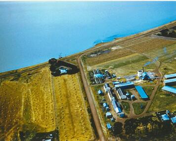 Lake Bolac & District Historical Society
Colour photograph, Lake Bolac Flax Mill, 1960
Aerial view of the Lake Bolac Flax Mill, circa 1960. Note the pump housing in front of Guy Rance's home, the polluted water entering the lake from the pipeline and the stooks of flax to the left of the road opposite the Mill.lake bolac, flax mill, 1960, rance -
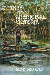 Victorian Aboriginal Corporation for Languages
Book, Aldo Massola, Journey to Aboriginal Victoria, 1969
Looks at the Aboriginal community from the time of white contact, across many parts of Victoria. Chap.1; Melbourne - early missions, camp of Native Police, corroboree trees, canoe trees, grave &? headstone of Derrimut; quarries at Keilor, excavation sites at Green Gully &? Keilor; quarry at Mt. William, notes on inheritance of quarries Coranderrk settlement - Barraks grave, notes on his life; Chap.2; Geelong - Yawangi group of the Wothowurong tribe, camping grounds in area quarries; Notes on William Buckley, Gellibrand (a notable Aboriginal), graves in the Western Cemetery; Chap.3; Colac - war between Colac &? Geelong tribes; Mission at Birregurra, reason for failure of Buntingdale Mission; brass plate to Coc-coc-coine; reserve at Elliminyt, native ovens, camp sites, initiation site &? ritual; quarry sites, axegrinding factory, rock pecking &? engraving; dried hand &? 3 Aboriginal skulls found; Chap.4; The south-west coast - middens, camp sites notes on Framlingham Stn., fish traps at Tyrendarra; Chap.5; The far west - massacres of Aborigines near Casterton; camp sites, oven mounds; the first cricket team formed; Aboriginal cemetery; Chap.6; Hamilton - camps; Mount Rouse Station, axegrinding grooves at Nareeb Nareeb, shelters described, fish traps, massacre at Lake Condah; mission; canoes; Chap.7; Camperdown - legend about Lake Bullen Merri; obelisk erected in memory of Aborigines of district especially chief Wombeetch Puyuun; Jarcoort tribe; fish weirs, camps, intertribal fights between Booluc-burrers, Jarcoorts &? Ellengermote groups; bartering place at Mount Noorat; articles traded, legend of Flat-Top Hill; Chap.8; Ballarat - camp at Lake Wendouree; White Stone Lagoon; legends concerning Mt. Buninyong &? waterfalls at Lal-lal; camp sites; pygmy-type implements near Meredith, quarry at Glue Pot Rocks near Durdidwarrah; brass plate of King Billy; Chap.9; Ararat - Tjapwurong territory; camp sites, quarries, shield &? canoe trees; Bunyip belief at Lake Buninjon of Muk-jarawaint &? Pirtkopen-noot tribes, gives legend; stone implements; mill stones; fish weirs; stone arrangement near Lake Wongan; ground drawing of a bunyip, paintings in rock shelter near Mt. Langi Ghiran; Chap.10; Maryborough - camps, oven mounds, rock wells, stone arrangement at Carisbrook; camp sites at Mt. Franklin; Chap.11; Charlton - belief in Mindye (snake); canoe trees, ovens, camp sites, water holes, rock wells, stone implements; method of rainmaking; Chap.12; Horsham-Stawell, The Wimmera - Wotjobaluk land; camps, fish traps at Toolondo; Black Range cave paintings, Flat Rock shelters (detailed account of these paintings); Bunjils Cave; Chap.13; Horsham-Stawell, The Mallee - camp sites, implements; Ebenezer Mission, Willie Wimmera taken to England by Rev. Chase to become a missionary, died in England; Chap.14; The Murray River, Mildura Swan Hill - Battle of the Rufus; ceremonial ground, Lake Gol Gol, canoe &? shield trees; stone implements; camp sites, fire place arrangements; fish traps; oven mounds; Chap.15; The Murray River, Swan Hill-Echuca - legend about Lake Boga; camps, oven mounds, the Cohuna skull, Kow Swamp, method of burial; Chap.16; Shepparton ovens; brass plates of King Paddy of Kotupna &? King Tattambo of Mulka Stn., native well, camps; Chap.17; Wangaratta -camps, quarry, rock holes, the Faithful massacre; grinding rocks at Earlston; Chap.18; The High Plains - Ya-itma-thang; camps, Bogong moth feasts, native paths for trade &? intertribal fights, articles traded; painted shelters; Koetong Ck. Valley, near Mt. Pilot &? near Barwidgee Ck.; Chap.19; Dandenong - water holes, list of 8 holes in Beaumaris - Black Rock area; camps, middens, stone implements (microliths), legend of Angels Cave, stone axes, Native Police Force, Narre Narre Warren Station, legend about rocks on Bald Hill, kangaroo totemic site; Chap.20; Wonthaggi- Yarram - natives visit Phillip Is., murder of William Cook and Yankee by five Tasmanians (listed as Bon Small Boy, Jack Napoleon Timninaparewa, Fanny Waterpoordeyer, Matilda Nattopolenimma and Truganini) near Cape Patterson, men; camp sites, middens, legend of White Rock; Chap.21; Sale - Bairnsdale, The Lakes Country middens, camps; legend at Wulrunjeri; story of a white woman supposedly living with with the Tutangolung tribe, efforts made to prove story; canoe trees; Chap.22; Sale-Bairnsdale, The Inland Braiakolung tribe, camps, implements, canoe &? shield trees; Ramahyuck Mission, grinding rocks, fights with Omeo tribe; native tracks, death through enemy magic - procedure, belief in ghosts; Chap.23; Lakes Entrance and the Country to the east - Kroatungolung people, legend of Kalimna Valley; camps, stones of Nargun, bunyip, devils at Lake Tyers, excavation at Buchan, carbon dates; middens, ochre at Cape Conrad, stone fish-hook file at Thurra River; note on Bidwel tribe; Each chapter gives historical details, early contacts, relationships with settlers; Aboriginal place names and detailed description of sites and geographical features.b&w photographs, b&w illustrations, colour illustrationsgeelong, colac, hamilton, camperdown, ballarat, ararat, maryborough, charlton, horsham, stawell, murray river, shepparton, wangaratta, dandenong, wonthaggi, yarram, sale, bairnsdale, lakes entrance -
Creswick Campus Historical Collection - University of Melbourne
Artwork, Pinus insignis logs ready for milling, Creswick Nursery and Plantations, 1928
Metal framed photograph. Copied and enlarged sepia image.Photograph -
Creswick Campus Historical Collection - University of Melbourne
Document, 1918- 1924
Saw Milling Leases RegisterDocument -
 National Wool Museum
Letter
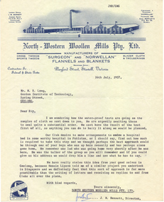
Letter, on "North Western Woollen Mills Pty Ltd" letterhead, 16th July 1957, regarding water proofing test resultswool - research wool - testing textile testing, gordon institute of technology north western woollen mills pty ltd, lang, dr w. roy, wool - research, wool - testing, textile testing -
![Sheet, water meter, [Commonwealth Woollen Mills, Geelong: "Venturi" Water Meter No1255]](/media/collectors/510b3f7f023fd725b4cd52cc/items/54065ff39821f50e3cc9fa37/item-media/54065ff39821f50e3cc9fa38/item-fit-380x285.jpg) National Wool Museum
National Wool MuseumSheet, water meter, [Commonwealth Woollen Mills, Geelong: "Venturi" Water Meter No1255]
... Mills, Geelong: "Venturi" Water Meter No1255] Sheet, water meter ...Acquired when "Classweave Industries" closed down.textile machinery, federal woollen mills ltd classweave industries pty ltd commonwealth woollen mills -
![Sheet, water meter, [Commonwealth Woollen Mills, Geelong: "Venturi" Water Meter No1255]](/media/collectors/510b3f7f023fd725b4cd52cc/items/54065ff39821f50e3cc9fa3b/item-media/54065ff39821f50e3cc9fa3c/item-fit-380x285.jpg) National Wool Museum
National Wool MuseumSheet, water meter, [Commonwealth Woollen Mills, Geelong: "Venturi" Water Meter No1255]
... Mills, Geelong: "Venturi" Water Meter No1255] Sheet, water meter ...Acquired when "Classweave Industries" closed down.textile machinery, federal woollen mills ltd classweave industries pty ltd commonwealth woollen mills -
National Wool Museum
Sheet, water meter, [Commonwealth Woollen Mills, Geelong: "Venturi" Water Meter No1255]
... Mills, Geelong: "Venturi" Water Meter No1255] Sheet, water meter ...Acquired when "Classweave Industries" closed down.textile machinery, federal woollen mills ltd classweave industries pty ltd commonwealth woollen mills -
 Stawell Historical Society Inc
Photograph - Aunde Album 29, Watching yarn come of Spools, 2002
Aunde / Norwellan Textiles North Western Woolen Mills became Norwellan Textiles then AUNDEColour photo: Water damaged. Portrait Yarn entering weaving machineindustry, aunde -
 Stawell Historical Society Inc
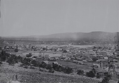
Photograph, View of Stawell from Big Hill 1874 showing mines looking towards South end of Black range -- 4 Photos
Visible Nelsons Criterion Hotel, Wimmera Crushing Mill, Odd Fellows Arms hotel, F.H. Oliver & Co Grain Merchant, Reefs Restaurant.Holtermann Black and White photograph of Stawell from Big Hill with mining in foreground. April 1874. Wimmera Crushing Mill and settling pond at centre of photograph. Stawell water supply centre left of photo. Black Range in Background.mining, panorama -
 Parks Victoria - Days Mill and Farm
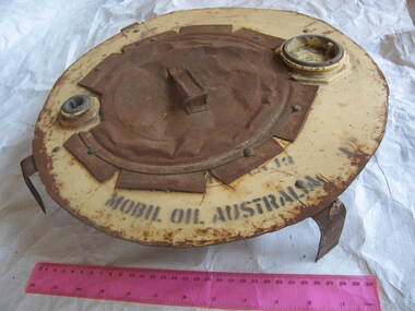
Functional object - Lid
Unknown. Possibly lid of water tank?Handmade remodelled lid, enamelled, cream colour, circular. Shape possibly cut with tin snips. Underside has 2 braces in cross shape riveted to lid. Braces bent down at edges of lid (possibly to fit on base?). Upper side, has lids, 1 toward top and 1 at bottom. Central metal piece with handle riveted to lid."MOBIL OIL AUSTRALIA"/ "USE ONLY/ Rheem/ RHEEM SPANNER"