Showing 204 items
matching webster street
-
 Eltham District Historical Society Inc
Photograph - Aerial Photograph, Landata, Lower Plenty, Vic, Apr. 1963
Centred on present day Old Eltham Road near Araluen Centre, Lower Plenty bounded by Cromwell Street to north, Yarra River to south, Main Road at Mount Pleasant Road to east and Panorama Avenue to west. Historic Aerial Imagery Source: Landata.vic.gov.au Aerial Photo Details: Project No :486 Project : MELBOURNE (1963) PROJECT Run : 7 Frame : 231 Date : 04/1963 Film Type : B/W Camera : RC8 Flying Height : 5100 Scale : 9600 Film Number : 1805 GDA2020 : 37°44'03"S, 145°07'56"E MGA2020 : 335420, 5822027 (55) Melways : 21 F10 (ed. 42)aerial photo, neil webster collection, 1963-04, araluen, cromwell street, eltham, lower plenty, main road, melway 21f10, mount pleasant road, old eltham road, panorama avenue, yarra river -
 Eltham District Historical Society Inc
Photograph - Aerial Photograph, Landata, Eltham, Vic, Apr. 1963
Centred on present day Eltham Lower Park bounded by Brougham Street to north, Yarra River and Fitzsimons Lane Bridge to south, Main Road at Kent Hughes Road to east and Bolton Street to west. Historic Aerial Imagery Source: Landata.vic.gov.au Aerial Photo Details: Project No :486 Project : MELBOURNE (1963) PROJECT Run : 7 Frame : 232 Date : 04/1963 Film Type : B/W Camera : RC8 Flying Height : 5100 Scale : 9600 Film Number : 1805 GDA2020 : 37°44'03"S, 145°08'33"E MGA2020 : 336329, 5822040 (55) Melways : 21 H10 (ed. 42)aerial photo, neil webster collection, 1963-04, bolton steet, brougham steet, eltham, eltham lower park, fitzsimons lane bridge, kent hughes road, melway 21h10, yarra river -
 Eltham District Historical Society Inc
Photograph - Aerial Photograph, Landata, Eltham, Vic, Apr. 1963
Centred on present day Griffith Park Road, Eltham bounded by Mount Pleasant Road to north, Yarra River and Templestowe to south, Main Road at Reynolds Road to east and Falkiner Street to west. Historic Aerial Imagery Source: Landata.vic.gov.au Aerial Photo Details: Project No :486 Project : MELBOURNE (1963) PROJECT Run : 7 Frame : 233 Date : 04/1963 Film Type : B/W Camera : RC8 Flying Height : 5100 Scale : 9600 Film Number : 1805 GDA2020 : 37°44'04"S, 145°09'10"E MGA2020 : 337237, 5822053 (55) Melways : 22 A10 (ed. 42)aerial photo, neil webster collection, 1963-04, eltham, falkiner street, griffith park road, melway 22a10, mount pleasant road, reynolds road, templestowe, yarra river -
 Eltham District Historical Society Inc
Photograph - Aerial Photograph, Landata, Eltham North, Vic, Apr. 1972
Centred on present day Eltham North reserve near Eltham North Primary School, Eltham North bounded by Allendale Road to north, Bellevue Road to south, Zig Zag Road and Beard Street to east and Ryans Road to west. Historic Aerial Imagery Source: Landata.vic.gov.au Aerial Photo Details: Project No :985 Project : MELBOURNE 1972 Run : 26 Frame : 190 Date : 04/1972 Film Type : B/W Camera : RC10 Flying Height : 5700 Scale : 9600 Film Number : 2636 GDA2020 : 37°41'52"S, 145°08'52"E MGA2020 : 336705, 5826102 (55) Melways : 11 J12 (ed. 42)aerial photo, neil webster collection, 1972-04, allendale road, beard street, bellevue road, eltham, eltham north, eltham north reserve, melway 11j12, ryans road, zig zag road, eltham north primary school -
 Eltham District Historical Society Inc
Photograph - Aerial Photograph, Landata, Eltham, Vic, Apr. 1972
Centred on present day Parsons Road, Eltham bounded by Allendale Road to north, Frank Street to south, Research Shops and Raglan Road to east and Zig Zag Road to west. Historic Aerial Imagery Source: Landata.vic.gov.au Aerial Photo Details: Project No :985 Project : MELBOURNE 1972 Run : 26 Frame : 192 Date : 04/1972 Film Type : B/W Camera : RC10 Flying Height : 5700 Scale : 9600 Film Number : 2636 GDA2020 : 37°42'00"S, 145°09'59"E MGA2020 : 338360, 5825897 (55) Melways : 22 D1 (ed. 42)aerial photo, neil webster collection, 1972-04, allendale road, eltham, zig zag road, frank street, melway 22d1, parsons road, raglan road, research (vic.), research shops, eltham barrel -
 Eltham District Historical Society Inc
Photograph - Aerial Photograph, Landata, Eltham, Vic, Apr. 1972
Centred on present day Main Road at Pryor Street, Eltham bounded by Park West Road to north, Napoleon Street to south, Woodridge Estate to east and Ryans Road to west. Historic Aerial Imagery Source: Landata.vic.gov.au Aerial Photo Details: Project No :985 Project : MELBOURNE 1972 Run : 27 Frame : 47 Date : 04/1972 Film Type : B/W Camera : RC10 Flying Height : 5700 Scale : 9600 Film Number : 2636 GDA2020 : 37°42'45"S, 145°09'12"E MGA2020 : 337223, 5824470 (55) Melways : 22 A4 (ed. 42)aerial photo, neil webster collection, 1972-04, eltham, eltham railway station, woodridge estate, eltham shops, main road, melway 22a4, napoleon street, park west road, pryor street, ryans road -
 Eltham District Historical Society Inc
Photograph - Aerial Photograph, Landata, Eltham, Vic, Apr. 1972
Centred on present day Ryans Road at Sandra Avenue, Eltham bounded by Progress Road to north, Brougham Street to south, Bible Street to east and Outlook Crescent to west. Historic Aerial Imagery Source: Landata.vic.gov.au Aerial Photo Details: Project No :985 Project : MELBOURNE 1972 Run : 27 Frame : 48 Date : 04/1972 Film Type : B/W Camera : RC10 Flying Height : 5700 Scale : 9600 Film Number : 2636 GDA2020 : 37°42'41"S, 145°08'38"E MGA2020 : 336392, 5824574 (55) Melways : 21 H4 (ed. 42)aerial photo, neil webster collection, 1972-04, eltham, bible street, brougham steet, melway 21h4, outlook crescent, progress road, ryans road, sandra avenue, montmorency -
 Eltham District Historical Society Inc
Photograph - Aerial Photograph, Landata, Montmorency, Vic, Apr. 1972
Centred on present day Olympic Avenue at Grand Boulevard, Montmorency bounded by Meruka Drive to north, Main Road to south, Main Road to east and Alban Street to west. Historic Aerial Imagery Source: Landata.vic.gov.au Aerial Photo Details: Project No :985 Project : MELBOURNE 1972 Run : 28 Frame : 206 Date : 04/1972 Film Type : B/W Camera : RC10 Flying Height : 5700 Scale : 9600 Film Number : 2635 GDA2020 : 37°43'21"S, 145°07'46"E MGA2020 : 335154, 5823329 (55) Melways : 21 E7 (ed. 42)aerial photo, neil webster collection, 1972-04, eltham, alban street, grand boulevard, lower plenty, main road, melway 21e7, meruka drive, montmorency, olympic avenue -
 Eltham District Historical Society Inc
Photograph - Aerial Photograph, Landata, Eltham, Vic, Apr. 1972
Centred on present day Diamond Creek Trail at the Eltham Leisure Centre bounded by Central Park to north, Main Road at Falkiner Street to south, MacMahon Ball Paddock to east and Grand Boulevard at Buena Vista Drive to west. Historic Aerial Imagery Source: Landata.vic.gov.au Aerial Photo Details: Project No :985 Project : MELBOURNE 1972 Run : 28 Frame : 207 Date : 04/1972 Film Type : B/W Camera : RC10 Flying Height : 5700 Scale : 9600 Film Number : 2635 GDA2020 : 37°43'25"S, 145°08'20"E MGA2020 : 335985, 5823223 (55) Melways : 21 G7 (ed. 42)aerial photo, neil webster collection, 1972-04, eltham, buena vista drive, central park, diamond creek trail, eltham leisure centre, falkiner street, grand boulevard, macmahon ball paddock, main road, melway 21g7 -
 Eltham District Historical Society Inc
Photograph - Aerial Photograph, Landata, Eltham, Vic, Apr. 1972
Centred on present day Dalton Street at Mount Pleasant Road, Eltham bounded by Arthur Street to north, Yarra River and Kent Hughes Road to south, Eucalyptus Road to east and Susan Street to west. Historic Aerial Imagery Source: Landata.vic.gov.au Aerial Photo Details: Project No :985 Project : MELBOURNE 1972 Run : 28 Frame : 208 Date : 04/1972 Film Type : B/W Camera : RC10 Flying Height : 5700 Scale : 9600 Film Number : 2635 GDA2020 : 37°43'29"S, 145°08'54"E MGA2020 : 336816, 5823118 (55) Melways : 21 J8 (ed. 42)aerial photo, neil webster collection, 1972-04, eltham, arthur street, dalton street, eucalyptus road, kent hughes road, melway 21j8, mount pleasant road, susan street, yarra river -
 Eltham District Historical Society Inc
Photograph - Aerial Photograph, Landata, Eltham, Vic, Apr. 1972
Centred on present day Mays Road at Stringybark Road, Eltham bounded by Nyora Road to north, Yarra River to south, Reynolds Road to east and Bible Street to west. Historic Aerial Imagery Source: Landata.vic.gov.au Aerial Photo Details: Project No :985 Project : MELBOURNE 1972 Run : 28 Frame : 209 Date : 04/1972 Film Type : B/W Camera : RC10 Flying Height : 5700 Scale : 9600 Film Number : 2635 GDA2020 : 37°43'33"S, 145°09'28"E MGA2020 : 337647, 5823013 (55) Melways : 22 B8 (ed. 42)aerial photo, neil webster collection, 1972-04, eltham, bible street, mays road, melway 22b8, nyora road, reynolds road, stringybark road, yarra river -
 Eltham District Historical Society Inc
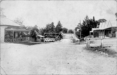
Photograph, Peter Pidgeon, Main Road at Pitt Street, Eltham, 2 Aug. 2022
Main Road looking north from Pitt Street. Comparison photo: SEPP_0626 - Main Road north of Pitt Street, c.1910 On the far left is Mrs Mary Ann Morris' house and shop and Hill's House. William Morris was the publican for the Evelyn Hotel which was on the opposite corner of Pitt Street and Main Road. Also believed to be the Scarce house at some stage, Mrs Emily Scarce was President of the Australian Women's National League. On the right is Webster's then the Commercial Bank of Australia branch, the Methodist Church just behind it on John Street. To the immediate right out of visibility is Watson's Eltham Hotel. Part of a presentation by Peter Pidgeon to the Society, 13 August 2022 showcasing a series of photographs taken by John Henry Clark over the period 1895 to 1930. John Henry Clark was the youngest of three boys born to William Henry Clark (1823-1877) and Maria White (1843-1914). He and his brothers, William Charles Clark (1872-1945), Clement Kent Clark (1874-1912) operated a photography business (Clark Bros.) from 25 Thomas Street, Windsor near Prahran during the period c.1894 to 1914. Following death of Clement in September 1912 and their mother in 1914, the Clark Bros business appears to have dissolved, the premises demolished, and a new house was under construction in 1915. John set up business independently in 1914 operating out of 29 Moor Street, Fitzroy where he is registered in the 1914 and 1915 Electoral Rolls. By 1916 John had relocated to Eltham where he continued his practice as a photographer and took many of the early images around the district of Little Eltham. Around 1930 John changed professions and opened a small cobbler's shop in 1931 near the pond opposite Dalton Street adjacent to the Jarrold family cottage. He never married and continued his profession as a bootmaker from this little shop, maintaining a close relationship with Mrs Jarrold for the rest of their lives. His bootmaker shop remains today beside the Whitecloud cottage and is one of only three remaining shops in the area from the early 20th century.Comparative photo taken 2022 with one taken from same location over 100 years earlier by noted local photographer J.H. ClarkBorn Digitaleltham, j.h. clark photo (2022), main road, pitt street -
 Eltham District Historical Society Inc
Document - Property Binder, 801 Main Road, Eltham
1. Plan: Henry Dendy's Eltham Land 1857-1867: showing Diamond Creek, Bridge Street, Maria Street now Main Road, John Street, Pitt Street, St Margaret's Church 1861, and Eltham Community Centre 1987. 2. Photocopy extract from "Henry Dendy and his emigrants" by L A Schumer, re Portions 12 and 13, Parish of Nillumbik. 3. The President and Councillors of the Shire of Eltham request the pleasure of ____ at the Official Opening of the Eltham Community Centre, Cnr Main Road and Pitt Street, Eltham by the Honorable R.J. Hamer E.D., M.P., Premier of Victoria on Saturday, 22nd April, 1978 at 3.30pm 4. Souvenir Program, Opening of Eltham Community Centre 22 April 1975. 5. Invitation to attend Official Opening of Eltham Community Centre by R J Hamer, Premier of Victoria, 22 April 1975. 6. Flier for Eltham Reception and Conference Centre, photographs of interiors during events. 7. Newspaper article: Eltham buries present for the future, Diamond Valley News 19 November 1985 Eltham, photograph of burying time capsule outside Eltham Community Centre, photograph of Bill Baker and Sid Brown outside old blacksmith shop the original site of Eltham town centre. 8. Letter Peter Butler Shire of Eltham to Eltham District Historical Society, 6 July 1987, detailing process for naming of the halls at the Eltham Community Centre.6 July 1987. 9. Plan of Main Road Eltham - it depicts buildings and occupiers from Pitt Street to Luck Street in the first half of the 20th century. This plan was compiled as a joint efforts by members of the Shire of Eltham Historical Society at a general meeting in Eltham during the 1980s. Newspaper article: Swimming pool and community centre receive major revamps, Diamond Valley Leader, 21 October 2015.main road, eltham, eltham community centre, henry dendy, eltham reception and conference centre, bill baker, sidney brown blacksmith, tme capsule, arthur street, babe taylor house, bakery, boarding house, bradley house, bridge street, brown blacksmith, burgoyne's shop, cockcrofts store, commercial bank of australasia, david lyon house, davis, dr cordner, dr hall, dudley street, eltham hotel, eltham obelisk, eltham war memorial, garnet burges, graham, hawker, henry street, john lyon, len perron, luck street, lyons garage, map, mechanics insitute, monteith house, mrs morris shop, our lady help of christian’s primary school, panther place, pitt street, prior street, shillinglaw cottage, shops, stones mixed shop, websters house, wesleyan methodist church, york street -
 Eltham District Historical Society Inc
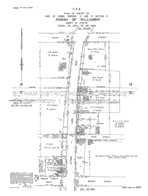
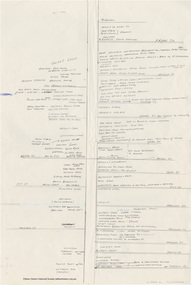
Document - Survey Plan, Country Roads Board, SP 6800, Eltham-Yarra Glen Road; Bridge St to Henry St, 1958
... Plan W.L. Chynoweth Pty Ltd York Street Neil Webster Collection ...1958 C.R.B. Plan of Survey of Part of Crown Portions 12 and 13 Section 4 Parish of Nillumbik, County of Evelyn Eltham-Yarra Glen Road., Shire of Eltham Shows Surveyor field notes, property ownership and building type and construction.1958, a.m. gahan, a.s & s.j. davis, annie ellen davies, bridge street, country roads board, d.a. lyon, dave lyon, eltham, flora towell, g.e. gallagher, henry street, j. lyon, k. greene, main road, p.a. gahan, survey plan, w.l. chynoweth pty ltd, york street, neil webster collection -
 Eltham District Historical Society Inc
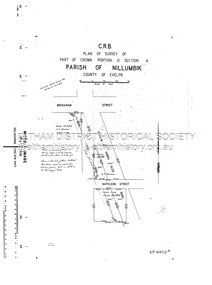
Document - Survey Plan, Country Roads Board, SP 6801, Eltham-Yarra Glen Road; Brougham St to Bridge St, 1958
1958 C.R.B. Plan of Survey of Part of Crown Portion 12 Section 4 Parish of Nillumbik, County of Evelyn Eltham-Yarra Glen Road, Shire of Eltham Shows Surveyor field notes, property ownership and building type and construction.a.j. collis, a.s. & c.g.h. fitzpatrick, board of land & works, bridge street, brougham steet, commonwealth bank of australia, country roads board, eltham, eltham rsl sub-branch, f.h. collis, f.m. smith, f.n. & e.j. burgoyne, franklin street, h.c. & r.e. burgoyne, j. jorgenson, j.f. & j.e. morris, j.n. & h.c. burgoyne, j.s. blow, john street, main road, p.e. smith, pitt street, r.j. dripps, s.j. taylor, survey plan, trustees of the eltham methodist church, 1958, eltham-yarra glen road, neil webster collection -
 Eltham District Historical Society Inc
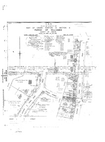
Document - Survey Plan, Country Roads Board, SP 6802, Eltham-Yarra Glen Road; Brougham St to Dalton St, 1958
... Road A.F. Munday Bible Street Brougham Steet Country Roads ...1958 C.R.B. Plan of Survey of Part of Crown Portion 12 Section 4 Parish of Nillumbik, County of Evelyn Eltham-Yarra Glen Road, Shire of Eltham Shows Surveyor field notes, property ownership and building type and construction.1958, eltham-yarra glen road, a.f. munday, bible street, brougham steet, country roads board, dalton street, eltham, j.p. & e.a. sanders, j.w. & e. m. graham, l.c. skipper, l.m. jarrold, main road, napoleon street, survey plan, neil webster collection, franco and co -
 Eltham District Historical Society Inc
Document - Survey Plan, Country Roads Board, SP 6313, Eltham-Yarra Glen Road; Luck St to Henry St, 1956
1956 C.R.B. Plan of Survey of Part of Crown Portion 13 Section 4 Parish of Nillumbik, County of Evelyn Eltham-Yarra Glen Road, Shire of Eltham Shows Surveyor field notes, property ownership and building type and construction.eltham-yarra glen road, country roads board, eltham, main road, survey plan, 1956, a.l. lyon, a.w. brinkkotter, arthur street, c.r. burkett, dudley street, e.n. staff, eltham war memorial trust, henry street, luck street, pryor street, the board of land & works, the equity trustees executors and agency coy ltd, the roman catholic trusts corporation, victorian railways commision, neil webster collection -
 Eltham District Historical Society Inc
Document - Survey Plan, Country Roads Board, SP 6559-6560, Eltham-Yarra Glen Road; Elsa Ct to Luck St, 1957
1957 C.R.B. Plan of Survey of Part of Crown Portion 13 Section 4 and Crown Allotment 1 Section 1 Parish of Nillumbik, County of Evelyn Eltham-Yarra Glen Road, Shire of Eltham Shows Surveyor field notes, property ownership and building type and construction.eltham-yarra glen road, country roads board, eltham, main road, survey plan, 1957, a.m. & a.a. iowerson, a.mcg. hepburn, cecil street, coffee lounge, diamond street, e.g. murrell, elsa court, h.b. woodhead, j.c. & s.i. harding, la ronde, luck street, r.m. & v.m. white, r.n. mowatt, the board of land & works, w.g. hains, neil webster collection -
 Eltham District Historical Society Inc
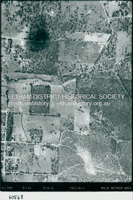
Photograph - Aerial Photograph, Landata, Eltham, Main Road; Henry St to Bellevue Rd, Dec. 1945
... Road Luck Street Main Road Pryor Street Neil Webster Collection ...Eltham, Main Road; Henry St to Bellevue Rd, and east along Luck St to present day Eltham East School Historic Aerial Imagery Source: Landata.vic.gov.au Aerial Photo Details: Project No :5 Project : MELBOURNE AND METROPOLITAN AREA PROJECT Run : 36 Frame : 60549 Date : 12/1945 Film Type : B/W Camera : EAG4 Flying Height : 10200 Scale : 6000 Film Number : 228 GDA2020 : 37°42'45"S, 145°08'59"E MGA2020 : 336903, 5824465 (55) Melways : 21 K4 (ed. 42)aerial photo, arthur street, bellevue road, bible street, diamond street, dudley street, elsa court, eltham, eltham east primary school, gahan house, henry street, livingstone road, luck street, main road, pryor street, neil webster collection -
 Eltham District Historical Society Inc
Photograph - Aerial Photograph, Landata, Eltham, Luck St; Bible St to Beard St, Dec. 1945
Centred on present day Eltham East Primary School, east of Main Rd along Luck St to Beard St Historic Aerial Imagery Source: Landata.vic.gov.au Aerial Photo Details: Project No :5 Project : MELBOURNE AND METROPOLITAN AREA PROJECT Run : 36 Frame : 60548 Date : 12/1945 Film Type : B/W Camera : EAG4 Flying Height : 10200 Scale : 6000 Film Number : 195 GDA2020 : 37°42'46"S, 145°09'18"E MGA2020 : 337371, 5824456 (55) Melways : 22 A4 (ed. 42)aerial photo, eltham, arthur street, beard street, bible street, eltham east primary school, frank street, henry street, luck street, stanley avenue, wycliffe crescent, neil webster collection -
 Eltham District Historical Society Inc
Photograph - Aerial Photograph, Landata, Eltham, Main Road; Mt Pleasant Rd to Railway Rd, Dec. 1945
Centred on Main Rd and Henry St, Eltham bounded by Railway Road to north, Mount Pleasant Road at Main Road to south, top of the hill in Arthur Street to east and Karingal Drive at Sherbourne Road to west. Historic Aerial Imagery Source: Landata.vic.gov.au Aerial Photo Details: Project No :65 Project : MELBOURNE AND METROPOLITAN PROJECT NO. 2 Run : 8 Frame : 70 Date : 01/1951 Film Type : B/W Camera : EAG9 Flying Height : 12200 Scale : 12000 Film Number : 1419 GDA2020 : 37°43'06"S, 145°08'45"E MGA2020 : 336589, 5823811 (55) Melways : 21 J6 (ed. 42)aerial photo, eltham, main road, henry street, arthur street, bolton street, eltham-yarra glen road, neil webster collection, 1951-01, dave lyon house, ernie andrew house, karingal road, melway 21j6, mount pleasant road, railway road -
 Glen Eira Historical Society
Document - Monkleigh, Gladstone Parade, 12, Elsternwick
... Parade Gladstone Road Carlingford Street Ellis Jabez Webster ...Three items aout this property:1/Copy of pages from Andrew Wards, Caulfield Conservation study document dated October, 1994. Gives a brief history of land owners and occupants of Monkleigh and copy of photo dated October, 1994. The document includes a brief history and a description of the house features. 2/Hand written research by Claire Barton taken from 'Trove' regarding former resident of 'Monkleigh' who went to World War One. 3/Printout dated 18/02/2014 from Roll of Honour - Charles Clifton Elliott with location of his name at theralian War Memorial.elsternwick, hume lucy, kooyong park estate, gladstone parade, gladstone road, carlingford street, ellis jabez, webster joseph, wimberley colin, vale chas., judge g.t., ward andrew, architectural styles, victorian style, architectural features, monkleigh, elliot charles clifton, elliott charles clifton, elliot e b mrs, elliott e b mrs, house names, station managers, world war 1914-1918 -
Glen Eira Historical Society
Letter - Elsternwick Fire Station, Selwyn Street
A one page typed letter, dated 18/02/1974, from the National Trust of Australia (Victoria) to the owner of the building at 2 Selwyn Street Elsternwick, the former Metropolitan Fire Brigade building, stating that the National Trust has recorded the building.joseph j webster pty ltd, fire stations, brick, architectural features, metropolitan fire brigade, selwyn street, elsternwick, companies, national trust of australia (victoria) -
 Eltham District Historical Society Inc
Document - Map, Doug Orford, Main Road, Eltham (c..1930s-1970s), c.2010
Map of Main Road with listings of all properties (shops/homes) from Mount Pleasant Road through to Pryor Street from the 1930s on to about the 1970sandrew store, andrews newsagency, arthur street, babe taylor house, bakery, barbers blue gum store, blue gum, boarding house, bootmakers cottage, bottle shop, bradford butcher shop, bradford house, bradley house, brdbury house, bridge street, brooker, brougham steet, brown blacksmith, browne's grocer, bryant, burgoyne post office, burgoyne's shop, capewell butcher shop, catholic church, catholic school, chandlers lolly shop, cheddar black, chiropractor, cockcroft, commercial bank of australia, copelands chemist, copelands dairy, d. hall house, dave lyon house, david lyon house, dr cordner, dr loosli, dr r. bradbury, dudley street, eltham, eltham bakehouse, eltham courthouse, eltham fire brigade, eltham living and learning centre, eltham pre-school, eltham railway station, eltham shire office, eltham station masters house, eltham war memorial, f. collis store, feed store, fountain hotel, franklin street, gadd's blacksmith, gahan house, garnet burges, george bird grocer, gollings, grant house, harry hawker, headmaster's resience, henry street, hepburn house, hills house, isherwood house and shop, jack ryan, jack shallard, james house, jarrold cottage, jim ryan, john lyon house, kilpatrick, le brocq, leather and harness, len parsons, lock-up, lyon bros garage, main road, map, mathews house, mclean's produce store, mechanics institute, methodist church, methodist hall, milkbar, mills bootmaker, miss george, monteith house, mount pleasant road, mrs bradbury, mrs davis house, mrs jewell, mrs mbremner store, mrs morris shop, napoleon street, obelisk, panther place, peter gahan, pitt street, plumber, police residence, poultry and market garden, pryor street, railway house, rains newsagency, real estate agent, reeves general store, s. bradbury, shillinglaw cottage, staffs general store, stones mixed shop, tennis court, timber yard, w. walker, w.b. andrew corn store, warren's general store, water trough, watsons hotel, websters house, whitecloud cottage, whites general store, williams bootmaker, wingrove cottage, wingrove park, woodyard, york street, franco and co -
Ballarat Clarendon College
Book
Books donated to the Weatherly Library at Ballarat College from old collegian J J McGowan in 1939. Jack entered Ballarat College in 1882. (Family Links) Son of Sam McGowan 15 Webster St, brother of Arthur.Twelve books of various titles and sizes, including a four volume set of The Waverley NovelsBook plates inside front cover: Crest / Ballarat College Library / PRESENTED BY / J J McGowan 1939.... Handwritten on flyleaf of Waverley novels: To dear Jack / From his Sisters / January 1st 1886j-j-mcgowan, jack-mcgowan, weatherly-library, ballarat-college, 1939, arthur-mcgowan -
 Greensborough Historical Society
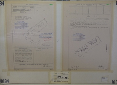
Planning Document, Subdivision Plan #1034. 50 Hume Street, 03/02/1982
Plan of Strata Subdivision at 50 Hume Street Greensborough for 7 units.An example of hard copy subdivision plans from the Greensborough area. Mainly from the Shire of Diamond Valley era (1964-1994).Plan (2 sheets) mounted on heavy card.Stamped and handwritten Council permissions, dates and other details.subdivision plan -
 Eltham District Historical Society Inc
Negative - Photograph, Main Road, Eltham, c.1910
... melbourne Main Road looking north from Pitt Street. On the far left ...Main Road looking north from Pitt Street. On the far left is Mrs Mary Ann Morris' house and shop and Hill's House. William Morris was the publican for the Eveyn Hotel which was on the opposite corner of Pitt Street and Main Road. Also believed to be the Scarce house at some stage, Mrs Emily Scarce was President of the Australian Women's National League. On the right is Webster's then the Commercial Bank of Australia branch, the Methodist Church just behind it on John Street. To the immediate right out of visibility is Watson's Eltham Hotel.This photo forms part of a collection of photographs gathered by the Shire of Eltham for their centenary project book,"Pioneers and Painters: 100 years of the Shire of Eltham" by Alan Marshall (1971). The collection of over 500 images is held in partnership between Eltham District Historical Society and Yarra Plenty Regional Library (Eltham Library) and is now formally known as the 'The Shire of Eltham Pioneers Photograph Collection.' It is significant in being the first community sourced collection representing the places and people of the Shire's first one hundred years.Digital image 4 x 5 inch B&W Negshire of eltham pioneers photograph collection, eltham, main road, scarce house, cba bank, gas lamp, hill's house, hostelry, john street, methodist church, pitt street, websters house, mrs morris shop -
 Australian Queer Archives
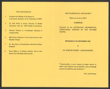
Ephemera, Australian Transsexual Association (ATA), The Transsexual and society : Where are we at in 1981? : a seminar, 1981
Additional text: "The participants: 1. Professor Ian Webster is Professor of Community Medicine at the University of NSW; 2. Dr Bob Webb is former Director of Health Education with the NSW Health Commission; 3. Roberta Perkins is a Sociologist majoring in transsexuality; 4. Bill Crews is Director of the Crisis Centre of the Wayside Chapel; 5. Dr. Ron Barr is a Psychiatrist with Prince Henry Hospital; 6. Bruce Miles is a Sydney solicitor who is well known for defending needy people."transexual, transgender -
Ringwood and District Historical Society
News Sheet, J. N. Webster, Town Clerk, City of Ringwood News Sheet February 1970, Feb-70
Tabloid 8 pages produced by the City of Ringwood for information of citizensCity of Ringwood News Sheet February 1970 containing photographs and current news items, list of councillors, funds received, funds expended, roads, buildings, street lighting, library, sports, health, welfare. +Additional Keywords: Hubbard, B.J., JP, Mayor / Aus, N. / Martin, R.J. / McRae, J.M. / Smart, G.R.G. / McCubbin, J.C.B., JP / Vergers, P., JP / Morris, S.C., JP / Palmer, Patricia E. -
 Federation University Historical Collection
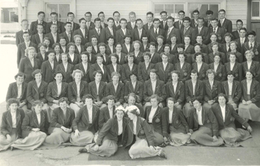
Photograph, Ballarat Teachers' College, 1953
The Ballarat Teachers' College is a predecessor institution of Federation University Australia. This photograph is reproduced in the 1953 edition of 'Extra Muros', the annual magazine of the Ballarat Teachers' College. Group of first year student of the Ballarat Teachers' College in the grounds of Dana Street Primary School, where their College was located. Back Row: D. Henderson, R. Veal, J. Brasier, D. Nunn, Ken Johnson, G. Osborne, P. Brumby, Graeme Anson, R. Williams, R. Romanes. M. Brennan, M. Jeffey, A. Brown. 2nd Row: John Dixon, K. Ryan, L. Coad, P. Callahan, John Gilbert, H. McLachlan, S. Morgan, J. Campbell, G. Keller, Ian Webster, R. Bryant, J. Hullick, K. Rogers, K. Greenway, B. Thomas. 3rd Row: J. Cameron, M. Simpson, M. McNeil, H. Cornish, C. Brown, A. Mead, Margaret Bywaters, D. Wallish, T. Everett, B. Wallace, A. Flavell, Gwen Brereton, M. Gebbie, V. Rodber, R. Dudley. 4th Row: M. Harvey, M. Beeson, Pat Wilkinson, M. Stevenson, L. Place, M. Barker, J. Bray, Gl. Evans, Gw Evans, D. Vary, Janifer Rogerson, P. Grubb, J. van Leeuwan, D. Bautovich. 5th Row: J. Filcock, J. Watts, B. Peterson, J. McArdle, Helen Sadler, J. Plush, Bette Harvey, R. Rule, E. Leach, D. Carroll, A. unn, B. Laurissen, V. James, J. Higgins. 6th Row: J. Turton, T. Nicoll, J. Wiltshire, A. Bolster, L. Howard, M. Corbett, M. Mill, M. McKay, I. Paul, J. Phelan, P. Ross, J. Piper, W. Jones. Front Row: N. McPherson, G. Lougheed, B. Tonks, I. Work, L. Hall, R. Mason, E. Menadue, E. Mercovich, J. McMillan, P. Fogarty. ballarat teachers' college, d. henderson, r. veal, j. brasier, d. nunn, k. johnston, g. osborne, p. brumby, g. anson, r. williams, m. jeffey, a. brown., k. ryan, l. coad, p. callahan, j. gilbert, h. mclachlan, s. morgan, j. campbell, g. keller, i. webster, r. bryant, j. hullick, k. rogers, k. greenway, b. thomas., m. simpson, m. mcneil, h. cornish, c. brown, a. mead, m. bywaters, d. wallish, t. everett, b. wallace, a. flavell, g. brereton, m. gebbie, v. rodber, r. dudley., m. beeson, p. wilkinson, m. stevenson, l. place, m. barker, j. bray, gl. evans, gw evans, d. vary, janifer rogerson, p. grubb, j. van leeuwan, d. bautovich., 5th row: j. filcock, j. watts, b. peterson, j. mcardle, h. sadler, j. plush, b. harey, r. rule, e. leach, d. carroll, a. unn, b. laurissen, v. james, j. higgins., t. nicoll, j. wiltshire, a. bolster, l. howard, m. corbett, m. mill, m. mckay, i. paul, j. phelan, p. ross, j. piper, w. jones., g. lougheed, b. tonks, i. work, l. hall, r. mason, e. menadue, e. mercovich, j. mcmillan, p. fogarty., r. romanes, m. brennan, j. dixon, j. cameron, m. harvey, j. turton, n. mcpherson, ken johnson, graeme anson, john gilbert, ian webster, margaret bywaters, gwen brereton, 4th row: m. harvey, pat wilkinson, helen sadler, bette harvey, a. nunn, john dixon