Showing 71 items
matching weight measurement
-
 Department of Energy, Environment and Climate Action
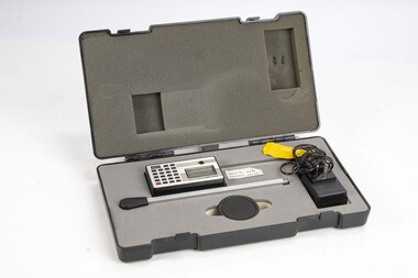
Planimeter (Digital)
The heavy weight is pinned onto the map and the tracing arm is used to follow the boundary to be measured. Reading from the digital scale the area in square centimetres could be measured. Knowing the scale of the mapsheet the figure was converted to areas or hectares Generally at least three measurements were taken to ensure accuracy and precisionPlanimeter used to measure areas from scale maps. Kent Planitron UP103forests commission victoria (fcv), forest measurement, surveying -
 Ballarat Tramway Museum
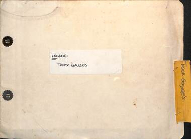
Administrative record - Report, State Electricity Commission of Victoria (SECV), "Legend - Track gauges", 1954/55
Record shows the condition of the rail head at many points throughout the Ballarat system. Gives the type of rail, its weight, gauge, location and date of measurement See item 9127 for a report on the Special Work. Some sections measured in May 1954, rest May 1955Demonstrates a detailed report into the condition and wear of the Ballarat Tramways trackwork in 1954/1955.Report - within a manila card folder with steel clips containing about 44 drawings on drawing paper of rail sections.Outside cover in ink "Legend Track Gauges"ballarat, secv, trackwork, rails, reports -
 Ballarat Tramway Museum
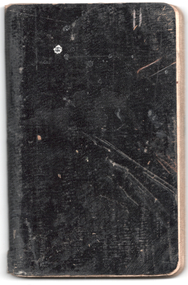
Administrative record - Ballarat Rail Profiles, Electric Supply Co. of Vic (ESCo), 2/1916
On the inside cover "Profiles of various parts of the tramway tracks, Ballarat Feb. 22, 1916. The profiles have been drawn in pencil from measurements at many locations. Gives the outline of the rail showing wear since 1905, location, and rail weight.Demonstrates and ESCo record of rail track wear after some 10 years of operation.Notebook - black card cloth based covers containing approx 50 ruled pages.tramways, ballarat, tracks, rail profiles, rails, esco -
 Linton and District Historical Society Inc
Pennyweights, Set of Standard Troy weights
Incomplete set of standard Troy weights (Pennyweights), used in the valuation and measurement of precious metals. Set consists of 6,5,4,2,1 and 1//2 pennyweights (3 is missing), and 6,5,4, and 2 grains (1 and 3 are missing).pennyweights, weights and measures, troy weights -
 Flagstaff Hill Maritime Museum and Village
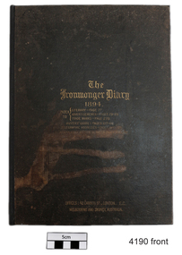
Book, The Ironmonger Diary 1894, circa 1894
The Ironmonger Diary 1894 is titled on top of the inner pages "The Ironmonger Diary and Text Book". The inner pages contain blank diary pages, two weeks to an opening, with a light weight, blank pink page between the weeks. There are also Cash Book pages. The front and back sections of the diary contain product advertisements for ironmonger's wares, hardware, household goods, farm machinery, bicycles and even some clothing. There are Tables of measurements, a green-aged section called Classified List of Trade Marks and Brands, The Buyer's Guide and a list of Hallmarks on Plate (such as gold) and the years of manufacture.The Ironmonger Diary 1894 is a hard covered book bound book with gold lettering on the front cover and spine. The front cover includes an index to the information inside. It is titled on top of the inner pages "The Ironmonger Diary and Text Book". The inner pages contain blank diary pages, two weeks to an opening, with a light weight, blank pink page between the weeks. There are also Cash Book pages. The front and back sections of the diary contain product advertisements for ironmonger's wares, hardware, household goods, farm machinery, bicycles and even some clothing. There are Tables of measurements, a green-aged section called Classified List of Trade Marks and Brands, The Buyer's Guide and a list of Hallmarks on Plate (such as gold) identifying the years of manufacture.Pencilled letters on the Hallmarks on Plate page beside some of the letters, identifying the letter on the Hallmark. On the cover is also stamped in gold lettering "OFFICES: 42 CANNON ST, LONDON. E.C./MELBOURNE AND SYDNEY, AUSTRALIA"flagstaff hill, warrnambool, shipwrecked-coast, flagstaff-hill, flagstaff-hill-maritime-museum, maritime-museum, shipwreck-coast, flagstaff-hill-maritime-village, ironmonger diary, 1894, hardware catalogue, hardware diary -
 Flagstaff Hill Maritime Museum and Village
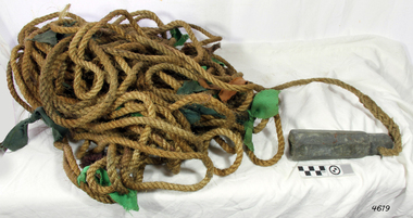
Equipment - Lead line
The lead line or hand lead is a simple navigational instrument used as a depth finder to measure the depth of water under the ship’s keel and to take samples of the sea bed. The long line may be marked at regular intervals with tags of different coloured and textured fabric, such as rope, leather and cloth. Each tag was a code to represent a certain depth. The leadsman’s eyes and hands could distinguish the depth easily as he drew in the lead line, day or night and in poor weather conditions. A standard set of codes for the tags was used so that the depth of the sea could be easily and quickly read. The measurement used was a Fathom, which equals 1.83 metres. The codes were: - 2 fathoms = 2 strips of leather 3 fathoms = 3 strips of leather 5 fathoms = white duck fabric 7 fathoms = red bunting fabric 10 fathoms = leather with a hole 13 fathoms = blue serge fabric 15 fathoms = white duck fabric 17 fathoms = red bunting 20 fathoms = 2 knots The lead weight could be between 7 -14 pounds (3.5 – 6.5kg) and the rope would be approximately 25 fathoms (45m). The hollowed-out end of the weight would hold a stick substance such as tallow or wax, which would pick up samples from the sea bed which would show whether the vessel was close to, or far away from, the shore. The leadsman would stand at the front of the vessel and cast the lead line into the sea. When it hit bottom he would note the tag marker nearest the surface of the water and call out his finding. Then he would haul it up again and examine the kind of matter that adhered to the end of the weight, whether it be sand, mud, gravel, or the colour of it. This information would be given to the ship’s helmsman or navigator and would help indicate the proximity to the land.This handheld lead is an example of early marine navigational equipment used by sailors to travel the seas to measure the depth of the water and sample the nature of the seabed. It helps to understand the history and progress made from the very basic to the sophisticated technology of today.Lead line, sounding line or depth finder. The long length of rope has a heavy lead weight attached to the end. Coloured fabric tags are tied onto the rope at regular intervals, representing different depths. The concave base of weight holds sticky substances such as tallow or beeswax, providing an adhesive surface to collect samples of sea bed like sand, shells or pebbles. flagstaff hill, warrnambool, shipwrecked coast, flagstaff hill maritime museum, maritime museum, shipwreck coast, flagstaff hill maritime village, lead line, depth finder, hand lead, sounding lin, leadsmane, navigation instrument, leadline, hand lead line -
 Broadmeadows Historical Society & Museum
Machine - Scales
Fairbanks weighing scales (to weigh 2 lb) - Fairbanks' most famous invention then became the platform scale for weighing heavy objects. This item is significant as it demonstrates a by-gone method of weighing mail. It is also significant as it uses pre-metric measurements, placing its age before 1966.Post office scales with two dishes and five weights ranging from 1 oz to 2 lb.To weigh 2 lb - Fairbanks, Birminghamscales, postage, mail -
 University of Melbourne, Burnley Campus Archives
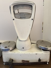
Machine - Scales, W & T Avery Ltd, Set of manual scales with weights, Mid 20th Century
... Scales measurement weighing weights AVERY FOR TRADE ...Avery metal manual scales with measurement in grams - with adjustable chrome feet. Accompanied by an array of weights of varying brands (Mercury, MSC, unmarked) 2 x 7LB, 3 x 4LB, 1 x 3LB, 1 x 2LB, 3 x 1LB, 8OZ and 4OZ.AVERY FOR TRADE VICTORIAN PATTERN APPROVAL No. V8 To Weigh Chart MARKED BY 2 GRAM DIVISIONS MADE IN ENGLAND BY W&T AVERY LTD BIRMINGHAM No 1215 BFH/S - 680767scales, measurement, weighing, weights -
 Department of Energy, Environment and Climate Action
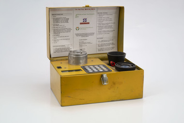
Prototype fuel moisture meter
Bushfire behaviour is influenced by many things including temperature, relative humidity, forest type, fuel quantity and fuel dryness, topography and even slope. Wind has a dominant effect on the Rate of Spread (ROS), and also bushfire size, shape and direction. Fuel arrangement is as important as fuel quantity (tonnes/ha). Fibrous and ribbon bark, together with elevated and near-surface scrub fuels act as ladders which lead flames into the tree canopy. But the availability of fuel to burn depends largely on its moisture content. When it exceeds 20-25% not much will burn, whereas 12-15% is generally ideal for fuel reduction burning, but if the moisture content drops as low as 7-10% virtually everything will ignite, and fire behaviour becomes extreme. During the afternoon of the Ash Wednesday bushfires on 16 February 1983 fuel moisture contents were recorded at Stawell as low as 2.7%. Fine fuels like leaves and bark can rapidly absorb moisture after a shower of rain, or from the air when the Relative Humidity (RH) is high, and the temperature is low. Conversely, they can also dry out very quickly. So even though the overall fuel quantity in the forest doesn’t change, the fine fuel availability can increase rapidly from zero after rain to many tonnes per hectare as the fuel dries out. This can happen over a few hours on hot and windy days. Heavy fuels like logs on the ground take longer to dry out. Since the 1930s foresters, firefighters and researchers have been working to develop quick and reliable techniques for measuring fuel moisture content. One of the most accurate methods is slowly drying a sample of fuel in a conventional oven for 24-48 hours to remove all the moisture and measuring the weight difference, but this takes time and is not practical in the field when rapid measurements are needed. But oven drying is often used as a benchmark to compare other methods. Microwave ovens are faster but can cause uneven drying and even char the fuel. They are also not very practical for use in the field. Some mathematical models rely on weather records such as rainfall, wind speed, evaporation, cloud cover, shading, relative humidity, slope, aspect and season of the year to predict soil and fuel moisture. The Keetch-Byram Drought Index of soil dryness is the most common. But complex fuels with leaves, twigs, grass etc make the predictive models often inadequate for fine fuels. The most common technique in Victorian forests until recently was the trusty Speedy Moisture Meter. Originally developed in England during the 1920s for measuring moisture in wheat and other grains it was adapted for Australian forest fuels in the 1950s (I think). Fuel was first ground using a Spong mincer, often attached to the bullbar of a vehicle, and a small sample placed into the Speedy together with a measure of calcium carbide and then sealed. A chemical reaction created gas pressure which was read on the external dial. There were important techniques with cleaning, mincing and using the chemicals with the Speedy to give reliable readings, but it was quick, inexpensive, robust, portable and practical in the field. It was used routinely before igniting a fuel reduction burn or measuring fuel moisture differentials on slash burns. But in about 1996, Karen Chatto and Kevin Tolhurst from the Department’s Creswick Research Station developed the Wiltronics Fuel Moisture meter which measured electrical resistance. Wiltronics is an Australian owned company operating from Ballarat. The final result was a kit that was portable, accurate and could reliably measure fuel moisture contents between 3% and 200%. Although expensive, it is now widely used by fire agencies around the world which has virtually relegated the Speedy to the back cupboard.Prototype Fuel moisture meterT-H Fine Fuel Meterforests commission victoria (fcv), bushfire, forest measurement -
 Alfred Hospital Nurses League - Nursing Archive
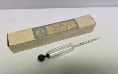
Instrument - Specific gravity urinometer, Diabetes Urinometer
Glass urine specific gravity measure.Cream coloured manufacturers box labelled with a pale blue and cream label: "Diabetes Urinometer and Specimen Tube. Manufacturer Precision Glass Instrument Co, Melbourne". Blown glass urinometer used to measure the specific gravity of urine. It consists of 3 parts: I. The float: is the air containing part II. Weight: the lower end of urinometer (metal ball bearings) III. Stem- Has calibrations with numbers marked to measure the specific gravity Missing urine holding specimen tubeHospital type diabetes urinometer 60 degrees F Precision Glass Instrument Co. Melb. Measurements on stem from 000 to 030 urine specific gravity measure, urine testing -
 Bendigo Military Museum
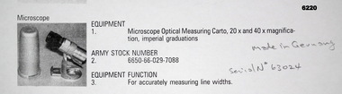
Instrument - Microscope Optical Measuring Cartographic, Hensoldt Wetzlar, Circa 1960
A very accurate microscope for measuring cartographic line-weights (thickness) during the Mapping process. Could be used to measure positive or negative line-weights or scribed lines in imperial measurements. Used at the Army Survey Regiment during the manual production of maps or charts.Silver alloy protecting Tube 5.5cms diameter and 12cms in height containing a Cartographic Microscope with imperial measurements. The Microscope is capable of 20 to 40 times magnification.Manufactured by "HENSOLDT WETZLAR" Serial Number 63024royal australian survey corps, rasvy, fortuna, army survey regiment, army svy regt, asr