Showing 392 items matching "werribee"
-
 Melbourne Legacy
Letter, Creation of Western Branch of Melbourne Legacy, 1999
These are letters from 1999 concerning the formation of the Western Branch of Melbourne Legacy, and other branch matters. The Footscray/Sunshine branch and the Williamstown/Werribee branch were merged in 1999. The documents give information about Junior Legatees and Widows under their care, and a brief history of the Williamstown/Werribee branch.The letters bring to our notice the amalgamation of two branches due to declining Legatee numbers and the ability of the remaining Legatees to provide the service of care under the Legacy Charter. White A4 paper with black type. One letter hand written in black ink. Some notations hand written in ink.branch, membership -
 Ballan Shire Historical Society
Map - Map. Moorarbool East and West, Country Lands in the Parishes of Moorarbool East and Moorarbool West. Counties of Bourke and Grant
This is a map of "Country Lands" around the Werribee River, north of Ballan in the Counties of Bourke and Grant.A relatively small map, paper on a material backing. Shows topographical features, roads and property divisions. Scale of forty chains to one inch. The map is dated March 31st, 1859.There is a small inscription under the chain scale that reads "No 58/364 John Phillips ? Survey 1st August 1858". The name Dugald McPherson is hand written on one of the blocks of land.moorarbool west, moorarbool east, dugald mcpherson, county of bourke, county of grant, werribee river, ballan -
 Federation University Historical Collection
Map, Melbourne, Victoria, 1933
Printed colour map.melbourne, port phillip bay, werribee river, werribee, port melbourne, hobson's bay -
 Clunes Museum
Book, DESIGNED BY PETER BUCKMASTER, WOOL PAST THE WINNING POST: A HISTORY OF THE CHIRNSIDE FAMILY, 1978
A BIOGRAPHY WRITTEN BY HEATHER B. RONALD OF THE HISTORY OF THE CHIRNSIDE FAMILY SOME OF WHO SETTLED ON LAND NEAR CLUNES, VICTORIA A SUMMARY OF THE CHIRNSIDE FAMILY'S MOVE TO THE AUSTRALIAN COLONIES AND THEIR CONTRIBUTION TO THE WOOL INDUSTRY IN THE 1800'S AND ONWARDSHARDCOVER BOOK BOUND IN BLUE LFABRIC WITH A GOLD EAGLE EMBOSSED ON THE FRONT COVER, COMPLET WITH DUST COVER. THE DUSTCOVER FRONT COVER HAS A COLOUR IMAGE OF A COLONIAL HOMESTEAD IN THE BACK GROUND WITH A LOADED DRAY PULLED BY OXEN TWO FIGURES WITH BULL WHIPS AT EITHER SIDE OF THE THE ANIMALS 203 PAGESnon-fictionA BIOGRAPHY WRITTEN BY HEATHER B. RONALD OF THE HISTORY OF THE CHIRNSIDE FAMILY SOME OF WHO SETTLED ON LAND NEAR CLUNES, VICTORIA A SUMMARY OF THE CHIRNSIDE FAMILY'S MOVE TO THE AUSTRALIAN COLONIES AND THEIR CONTRIBUTION TO THE WOOL INDUSTRY IN THE 1800'S AND ONWARDS book, chirnside family, clunes first sheep run -
 Bendigo Historical Society Inc.
Document - CONSERVATORY BUILDING
7 page document on the building and various relocations of the Conservatory building first erected in the Melbourne Botanic Gardens in 1880 and used as a Palm House. Other locations: Melbourne Zoo 1940 Werribee Zoo 1970 CoGb 2001 - gifted for White Hills Botanic ardens Included in the Bendigo Botanic Gardens Master plan as a long term action for reconstruction.bendigo, buildings, conservatory bendigo botanic gardens -
University of Melbourne, Burnley Campus Archives
Booklet, Anne Goudie, Agriculture Science, 1960
This subject was taught to school students who came to Burnley College for tuition. -
 Westbourne Grammar Heritage Collection
Photograph - The Site for Westbourne 1977
In 1975 a School Council subcomittee was formed to select a new principal to instigate the development of secondary schooling at Williamstown Grammar. By 1977 the appointed principal, John Roberts Pascoe, had worked tirelessly assessing options in and around Williamstown and looking for support for the school's expansion plans. He found that support in the Werribee Council and Werribee community, which recognised the potential of an independent school for the expanding area. In 1977, based on demographic research and feasibility studies, fifty acres of land was purchased on Sayers Rd. at Truganina (then Werribee). This photograph shows that land, the site for the new secondary school for Williamstown Grammar, looking east at the corner of Sayers Rd & Marquands Rd, which would be a very different view today.Colour photograph of a cloudy sky and cleared land with a perspective line of telegraph poles extending from the right into the middle background.campus, secondary, expansion -
 Melton City Libraries
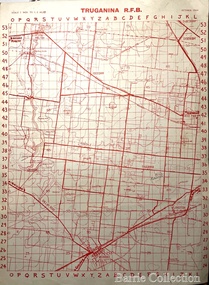
Map, Truganina R.F.B, 1964
The Mount Cotterill Group encompassed the Rural Fire Brigades of Melton, Rockbank, Sydenham, Toolern Vale, Truganina, and Werribee and later Diggers RestMap belonging to the Truganina Fire Brigade emergency services -
 Bacchus Marsh & District Historical Society
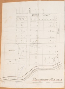
Map, Langmann's Estate Bacchus Marsh
The date of this map has not been determined. It bears the signature of D.A. Little upon of a portion of the map. Little was Bacchus Marsh Shire Secretary and Engineer between 1886 and 1914 which dates the map to some time between 1886 and 1914.A single page paper map showing a portions of land in part of Bacchus Marsh.The area shown is described as Langmann's Estate. The area is bounded by the Werribee River, Fisken Street, Waddle Street(sic.) (Waddell) and Lord Street. The map is pasted into a bound volume containing 76 maps or plans in total. High resolution digital image stored on BMDHS computer network. bacchus marsh victoria maps -
University of Melbourne, Burnley Campus Archives
Document, Edna Walling, McLennan, John Paul, 1917-1966
Photocopy - typed 1. Photocopy - handwritten Letter to Mr McLennan from HC Wilson, Department of Agriculture Victoria Agricultural Division Research Farm Werribee. Request for trees to be sent from Burnley 2. Memo for Mr McLennan Department of Agriculture Victoria Agricultural Division, Melbourne 9th August 1917. From A Richardson, Agricultural Superintendent, Order for trees to be sent to Werribee 3. Historical notes 4. Notes from Edna WallingHandwritten historical notes + diagrams, memo, letter from Edna Walling. Dates 8/8/1917 9/8/1917edna walling, handwritten notes, 1910s, 1917, john paul mclennan, burnley gardens -
 Eltham District Historical Society Inc
Newsletter, Newsletter, No. 15 November 1980
Contents: • Next meeting: Lucky Dip – Examination of Council historical records • Werribee Park excursion • Eltham Community Festival • Yarra Valley Metropolitan Park The Shire of Eltham Historical Society was formed in October 1967. The first newsletter of the Society was issued May 1978 and has been published continuously ever since on a bi-monthly basis. With the cessation of the Shire of Eltham in late 1994, the Society's name was revised to Eltham District Historical Society and this name first appeared with issue No. 103, July 1995. The collection of the Society's newsletters provides a valuable resource on the history of the Society's activities, office bearers and committee members, guest speakers and subjects of historical interest pertinent to the former Shire of Eltham and the Eltham District.A4 photocopied newsletter distributed to membersnewsletter, eltham district historical society, shire of eltham historical society -
 Ringwood and District Historical Society
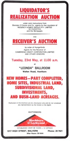
Pamphlet, Liquidator's and Receiver's Auction, Highland Boulevard, Ringwood, Victoria, and other locations - Circa 1980
Multi-fold brochure with Order of Sale list of home sites, industrial land, subdivisional land and bushland acreages being auctioned at "Leonda" Ballroom, Hawthorn, Vic., Tuesday 23rd May (year not documented, circa 1980). Brochure includes 8 homesites with handwritten sales notations for Lots 94, 99, 100, 102, 104 and 105 Highland Boulevard, Ringwood at 11.30a.m., and at 11.45a.m., 3 completed homes at Lots 86, 88 and 89 & 5 near-completed homes Lots 74, 75, 76, 77 and 79 Highland Boulevard. Auctioneers - Blackburn & Lockwood Pty Ltd., 1017 High Street, Malvern, Phone 207821 After Hours 20 4444.Liquidator's Realization Auction under joint instructions from Brendan O'Connor and Co., agents for the Liquidator of Regency Homes Group Pty. Limited (in Liquidation) and the Mortgagee. Receiver's Auction by order of Hungerfords, Agents for the Receiver of Cambridge Credit Corporation Limited and other vendors. Order of Sale property locations include Mulgrave, Ringwood, Doncaster, Portartlington, Geelong, Altona, Mooroolbark, Scoresby, Gembrook, Maidstone, Port Melbourne, Laverton, Werribee, Werribee North, and Sunshine. -
 B-24 Liberator Memorial Restoration Australia Inc
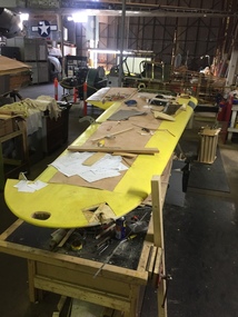
Airspeed Oxford aircraft (Replica under construction), c.1940
This type first flew in 1937 and by the start of WWII it was the preferred aircraft in all Empire Air Training Schemes for multi-engine pilot training. By the beginning of WWII the Airspeed Oxford was the preferred aircraft in all Empire Air Training Schemes for multi-engine pilot training. As of April 2014, no Airspeed Oxfords remain in the world in airworthy condition and there are very few complete air frames. There are reportedly some restoration-to-fly projects underway, one in New Zealand.Full-sized replica of an Airspeed Oxford aircraft. This type of aircraft was described as a multi-engine three-seat advanced military trainer monoplane. It was a wooden construction using plywood and fabric covering and powered by two 375 HP Armstrong Siddeley Cheetah 10 engines. Parts originally used a base for this reconstruction were reckoned to be from an Oxford Mk 2 with registration A25 LX181 which was based at Point Cook and used extensively in training from the Werribee Aerodrome. -
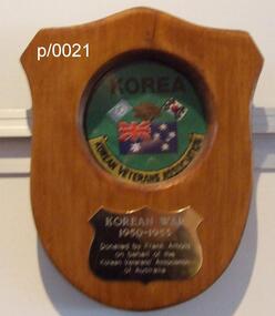 Waverley RSL Sub Branch
Plaque Korean War KVA (Korean Vetrans Association), Korean War KVA (Korean Vetrans Association)
http://www.austkoreavets.asn.au/content/application.html Membership application/renewal is to be printed, completed and mailed to The Treasurer, KVAA Inc.Attn: Gerry Steacy. 1 Kent Court, Werribee, Victoria 3030, Australia.Wooden Plaque 15cm x 13cmKorean War KVA (Korean Vetrans Association) -
 Bacchus Marsh & District Historical Society
Map, O'Hagan v Shire of Bacchus Marsh, Allotment 5, Sec 16, Parish of Korkuperrimul
The purpose for this map being created or the date when it was made has not been established. It appears to be documentation relating to a legal dispute by a landowner named O'Hagan and the Shire of Bacchus Marsh. Features identified on the map are allotment 5, section 16, Parish of Korkuperrimul, a 'cultivation paddock', a section of the Werribee River, the path of a section of a 'Main Channel', and a barrier or filled in section across the Werribee River called 'Lee's Filling'. The O'Hagan is likely to be Patrick O'Hagan, 1829-1914 who arrived in Bacchus Marsh in 1864 and was a prominent citizen and landowner in the area for many years until his death in 1914.Single page map showing allotment 5, section 16 in the Parish of Korkuperrimul, Scale 4 chains to inch. Part of a set of maps which are pasted into a bound volume containing 76 maps or plans in total. High resolution digital image stored on BMDHS computer network. Stamped: Munzt, Bace and Muntz, Civil Engineers and Licensed Surveyors , 388 Collins Streetbacchus marsh victoria maps, water supply structures and establishments, watercourses -
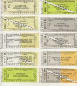 Melbourne Tram Museum
Ephemera - Ticket/s, Public Transport Corporation (PTC), Set of 21 The Met Neighbourhood tickets, 1989
Set of 21 The Met Neighbourhood tickets - May to August 1989. Conditions of use printed on rear. Printed on white paper. 1. Dandenong Neighbourhood - 183516 2. Ditto concession - 208212 3. Dandenong plus one Neighbourhood - 019512 4. Ditto concession - 018513 5. Ringwood Neighbourhood - 144534 6. Ditto concession - 168995 7. Werribee Neighbourhood - 018612 8. Ditto concession - 018959 9. Werribee plus inner Neighbourhood - 014015 10. Ditto concession - 008168 11. Ringwood plus one Neighbourhood - 024729 12. Ditto concession - 0198882 13. Inner Neighbourhood - B089291 14. Ditto concession - A088033 15. Inner plus one Neighbourhood - 359210 16. Ditto concession - 224012 17. Broadmeadows Neighbourhood - 044541 18. Ditto concession - 038635 19. Broadmeadows Plus Inner Neighbourhood - 034587 20. Ditto concession - 024933 21. Greensborough Plus One Neighbourhood concession - 003016trams, tramways, tickets, the met, ptc, neighbourhood tickets -
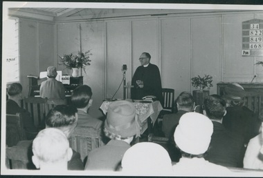 Uniting Church Archives - Synod of Victoria
Photograph, Undated c.1950s
Rev. John Wade was stationed at: 1934 Wangaratta; 1936 Cudgewa; 1941 Monbulk; 1942 Chaplain; 1943 Womboota, NSW; 1947 Horsham, Pimpinio; 1951 Werribee; 1957 Preston; Home Missions Director at the time of the formation of the Uniting Church.B & W photograph of the Rev. John Wade addressing a congregation. He is dressed in clerical stock and collar and academic grown. The congregation includes a woman at the keyboard of an harmonium."Rev. John Wade"wade, john, home missions, methodist -
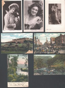 Bendigo Historical Society Inc.
Postcard - WES HARRY COLLECTION: 7 POSTCARDS, 1905 - 09
Group of seven postcards, three of them depict actresses and four are of various scenes around Victoria. (a) Miss Billie Bourke, (b) Carrie Moore, © Miss Carrie Moore as 'Honour in' Tom Jones ', (d) Bourke street on 8 hours day, Melbourne Victoria, (coloured) (e) Fairy Bend, River Yarra, Warburton (colour) (f) Werribee Gorge near Bacchus Marsh Victoria (colour) (g) Lawn Gardens, Flemington, Melbourne (colour).postcard, photograph, various themes, billie bourke, carrie moore, actresses, theatre, melbourne, flemington, werribee gorge, bacchus marsh, fairy bend, river yarra, warburton, bourke street, 8 hours day -
 Victorian Aboriginal Corporation for Languages
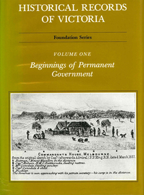
Book, Pauline Jones, Historical records of Victoria : volume 1 : beginnings of permanent government, 1981
Reproductions of various transactions and reports dealing with the early government of Port Phillip, including laws, surveyors? and administrators? reports, bills, requisitions, prices, police reports, and miscellaneous other documents dealing with the early administration of Port Phillip.victorian history, port phillip, governor bourke, geelong, john batman, treaty, william lonsdale, william buckley, werribee -
 Uniting Church Archives - Synod of Victoria
Photograph, Undated c.1950s
Rev. John Wade was a Methodist Minister stationed at: 1934 Wangaratta; 1936 Cudgewa; 1941 Monbulk; 1942 Chaplain; 1943 Womboota, NSW; 1947 Horsham, Pimpinio; 1951 Werribee; 1957 Preston; Home Missions Director at the time of the formation of the Uniting Church.B & W head and shoulders photograph of the Rev. John Wade."Rev. John Wade"wade, john, home missions, methodist, minister -
 Ballarat Heritage Services
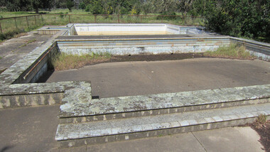
digital photographs, Lisa Gervasoni, Cocoroc pre olympic pool, c2010-2017
In 1892 the Melbourne and Metropolitan Board of Works established the Metropolitan Sewage Farm on the western bank of the Werribee River, to treat the effluent from Melbourne's new sewerage system.This area was isolated and too far from Melbourne, so the Cocoroc village was built to house the workers.Colour photograph of the Cocoroc Swimming Pool. This pool was built by the town's residents.swimming pool, sport, swimming, pre olympic, concrete, cocoroc, cocoroc swimming pool -
 Federation University Historical Collection
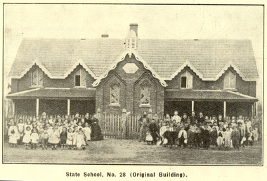
Booklet, Back to Bacchus Marsh, 1930, 1930
The 1930 Back to Bacchus Marsh celebrations were held on 23 to 28 October 1930. The committee were Cr L.M. Gugdale (president), A.W. Bond (General secretary), W. Grant Morton, J.G. Wells, Dr E. McDonald, Charles Dickie, G.H. Anderson, F.M. Crisp, W.R. Vigor. Bacchus Marsh State School No. 28 was established in 1851 as a National School in a rented building on the right-hand side of Bacchus Marsh-Melbourne Road, just beyond Woolpack Inn. Several willow trees mark the site. H.G. Ball was the first Head Teacher of the school, and the enrolmen towas 34. In 1854 Governor Charles Hotham visited the school. In 1855 two new schools, East and West, were recommended. School No. 28 closed in 1862 and the sitre was sold. The present school site was purchased in 1865 for 67 pounds. The cost of the building was 782 pounds. (Visions and Realisations, Vol 3., 1973) A clock purchased by public subscription was placed in the front of the building to the memory of scholars who served during World War One. (Back to Bacchus Marsh, 1930)Brown covered book of 44 pages. Contents include Bacchus Marsh and its soldiers, Red Cross, Lerderderg Gorge, Werribee Gorge, Lerderderg Park, Coimadai, Darely Firebrick Co., Myrniong, Underbank, Balliang, Rowsley, Parwan, schoosl, churches, Shire Council, Federal Milk Pty Ltd, Bacchus Marsh Milk, Old Maddingley Bridge Images include: * Bacchus Marsh looking east, 1930 * Bacchus Marsh Looking West, 1872 * Bacchus Marsh Looking West, 1930 * Aerial View of Bacchus Marsh Township looking east * Aerial View of Bacchus Marsh Township looking south * Bacchus Marsh Agricultural Society & Pastoral Society, 1893 (named), * Original Bacchus Marsh State School No 28 * Holy Trinity Bacchus Marsh * Bacchus Marsh Baptist Church * St Bernard's Catholic Church * Bacchus Marsh Methodist Church * St Andrew's Presbyterian Church Bacchus Marsh * View of Maddingley Park, showing Original Courthouse, 1890 * Werribee Gorge * Underbank Stud Farm * Ballarat State School Number 28. Signed 'C. Hodgson'bacchus marsh, maddingley, maddingley park, underbank, lerderderg park, coimadai, darely firebrick co., myrniong, balliang, rowsley, parwan, schoosl, churches, shire council, federal milk pty ltd, bacchus marsh milk, old maddingley bridge, police, police paddock, maddingley gates, crisp, mccormack, cain, harkness, howe, bence, mcdonald, mcfarlane, cosgrave, flagg, burnip, scott, lodge, cameron, vallance, bacchus marsh state school, bacchus marsh state school no 28., geology, r.w. thompson, lederderg gorge, weribee gorge, comadai, darley firebrick company -
Federation University Historical Collection
Booklet, Baxter & Stubbs, Printers and Bookbinders, Ballarat School of Mines Students' Magazine, Jubilee Year, 1920, 1920
Editorial, Fumes from the lab, Flotation process, A few notes on explosives, Trip to Werribee Gorge, Trip to Daylesford,Arts & Crafts gossip, Echoes of the past, Sport, Shun Military notes, The Junior Techs, Answers to correspondents, Sport, School notes, In memoriam, Maurice CopelandWhite soft covered magazine.ballarat school of mines, magazine -
 Melbourne Water
Photographic View Book, The Melbourne & Metropolitan Board of Works - Water Supply, Sewerage etc. ...Photographic Views, 1908
In 1891 The Melbourne and Metropolitan Board of Works (MMBW) was formed and became responsible for Melbourne's water supply. Melbourne had grown to a city of half a million people. To provide water to this rapidly growing city (especially the eastern suburbs), and to supplement the 1857 Yan Yean Reservoir, Melbourne's first water supply, the Watts River (near Healesville) was tapped. It supplied water to Melbourne, via the Maroondah aqueduct. In May 1892 the MMBW's first engineer-in-chief, Mr William Thwaites began construction on Melbourne's sewerage system. A treatment farm was built at Werribee and a pumping station was built at Spotswood (now the site of the Scienceworks Museum) to send the city's waste to Werribee. The first Melbourne homes were connected to the sewerage system in 1897. This book showcases the MMBW's infrastructure achievements and documents costs, requirements and key personnel involved in the development of the water supply and sewerage schemes.The introduction states "The water supply sources and headworks are in many cases situated in remote places and the sewerage works are chiefly underground. The Board has therefore resolved that these photographs of some of the scenes and works should be collected and bound for general information. August 1908" This book is in excellent condition and provides a detailed insight into the previous 17 years of work and the Board personnel of the MMBW leading up to 1908. It is of historical importance to the history of Melbourne for the photographic documents of places that were not generally open to the public, and for Melbourne Water in its detailed history of the MMBW in the early twentieth century. Photographic view book with hard khaki coloured cardboard cover and blue fabric binding. 120 Pages. Glossy paper with black and white plates and text about the MMBW, and scenic views and places of interest in association with the MMBW. The Melbourne & Metropolitan Board of Works - Water Supply, Sewerage etc. ...Photographic Views...mmbw, board members, sewerage, water supply, historic views, photographs -
 Lakes Entrance Historical Society
Photograph - Lakes Entrance Grid location, 1999
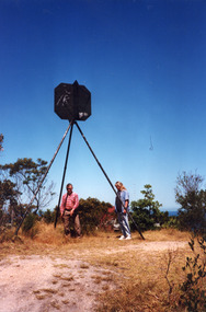
Lakes Entrance Grid reference, Cunninghame 8522.3.4 896.082, on ten acre site with trig point, it is from this point that all the survey for the surrounding areas was undertaken. Part of the Vic Geodetic Survey initiated in 1860 by Ellery Survey started from triangulation base in Werribee. (Grid ref B'dale 8422)Colour photograph of the Victoria Geodetic Survey Triangulation Station, Trig Station, situated off Ocean View Parade, Merrangbaur Hill. Location is indicated by ground point and standing structure, situated on an elevated bush block. Lakes Entrance Victoriasurveying, township planning -
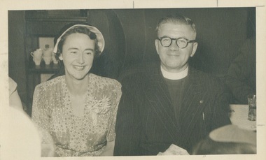 Uniting Church Archives - Synod of Victoria
Photograph, Undated c.1952
Rev John Edward Smith: b.1900; 1932 ordained Kergunyah; 1935 Port Campbell; 1937 Wycheproof; 1940 Werribee; 1947 Bendigo, St. John's; 1952 Albury; 1955 Essendon; 1967 Apollo Bay united; 1969 retired; 1971 emeritus, Presbytery of Melbourne West; 1986 died.B & W matte photograph of the Rev. J.E. Smith and an unidentified woman sitting together at a church function..presbyterian, minister, rev. john edward smith, albury, essendon -
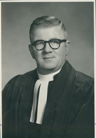 Uniting Church Archives - Synod of Victoria
Photograph, Undated c.1955
Rev John Edward Smith: b.1900; 1932 ordained Kergunyah; 1935 Port Campbell; 1937 Wycheproof; 1940 Werribee; 1947 Bendigo, St. John's; 1952 Albury; 1955 Essendon; 1967 Apollo Bay united; 1969 retired; 1971 emeritus, Presbytery of Melbourne West; 1986 died.B & W head and shoulders studio portrait of the Rev. John Edward Smith in clerical dress.presbyterian, minister, st. john's essendon, rev john edward smith -
Eltham District Historical Society Inc
Document - Folder, Murphy, James and descendants
James Murphy was a mining surveyor involved with the Caledonia diggings. Contents Note from Ray Blake, 26 April 2000: Ms Murphy said her people had traditionally owned all of inner Melbourne, north to the Great Divide, West to Werribee River, East to Mt Baw Baw, South to Mordialloc Creek.Newspaper clippings, A4 photocopies, etcjames murphy -
 Eltham District Historical Society Inc
Book, Melway Publishing, Melway Greater Melbourne street directory : including Geelong, Phillip Island, Healesville, Bellarine & Mornington Peninsulas, 2002
Edition 29. Coloured detailed maps accessed by a street or location index. Cover: 20 additional pages of new maps, extended coverage of Bellarine Peninsula, further coverage of Werribee South, Public Transport Information, latest official suburb boundaries, CBD "hook turn" intersections map, over 1200 new streets, 1 atlas (24, 886 p.) : col. maps ; ISSN 03113957streets, roads, melbourne, maps, melway -
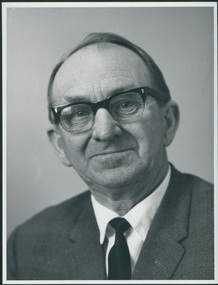
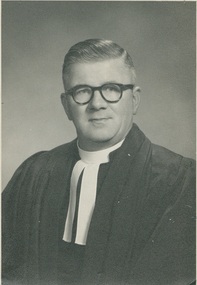 Uniting Church Archives - Synod of Victoria
Photograph, Undated c.1955
The Rev John Edward Smith was born in 1900, ordained in 1932 and died 1986. He served in 1935 Port Campbell; 1937 Wychproof; 1940 Werribee; 1947 Bendigo St. John's; 1952 Albury; 1955 Essendon St. John's and 1967 Apollo Bay. He retired in 1969 and in 1971 was appointed Emeritus Presbytery Melb. West.Black and white head and shoulders studio portrait of Rev. John Edward Smith. He is wearing glasses, looking at the camera and is wearing his clerical regalia. The back has the photographer's name and address, also that of the Rev Smith. It laso has various numbers and measurements indicating that the photograph was to be used in a publication."Rev. J. (John) Edward Smith. 853 Mt. Alexander Road, Essendon, W.5 PHONE FU1085" "The Dover Studio 17 HOLMES ROAD, MOONEE PONDS"presbyterian ministers, john edward smith, st john's presbyterian church essendon