Showing 4371 items
matching west street
-
 Stawell Historical Society Inc
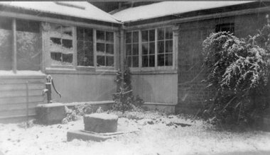
Photograph, Police House in Stawell West -- Corner of Griffin Street and Leslie Street with snow 1949
... Police House in Stawell West -- Corner of Griffin Street...Police Superintendents House Stawell West Corner of Griffin... House in Stawell West -- Corner of Griffin Street and Leslie ...Police Superintendents House Stawell West Corner of Griffin Street and Leslie Street with snow 1949stawell -
 Stawell Historical Society Inc
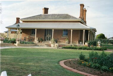
Photograph, Police House in Stawell West -- Corner of Griffin Street and Leslie Street -- 3 Photos -- Coloured
... Police House in Stawell West -- Corner of Griffin Street...Three Colour Photo of Police House Stawell West Corner... West -- Corner of Griffin Street and Leslie Street -- 3 Photos ...Three Colour Photo of Police House Stawell West Corner of Griffin Street and Leslie Streetstawell -
 Stawell Historical Society Inc
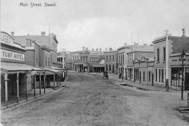
Photograph, Main Street Stawell looking West across Layzell Street intersection c 1900's
... Main Street Stawell looking West across Layzell Street...Main Street Stawell looking West across Layzell Street... grampians Main Street Stawell looking West across Layzell Street ...Main Street Stawell looking West across Layzell Street intersection. J Chadwick Drapers sign visible in centre of photo. Patrick Street runs off to the left of the photo behind wooden building the Foresters Hotel . Turf Hotel on left of photo. Horse drawn buggy near centre of photo. Circa 1900's. Same as 6730-2 & 0539 Turf Hotel on left, Forester Hotel on corner of Patrick Street, verandah of D. Fern Hotel / Times Office, McKeller Building. Across Main street in distance is J Allingham Draper, New Union Bank, Chadwick Drapers / Liddiard's , D. Telford Produce, Bank of Victoria, Oriental Bank / O'Driscoll's, J. Punchard furniture, A.B. Clemes, Bennett & Briston, Union Bank Australia, R.W, Dane Grocer on corner of Layzell Street. Same as 6730-2 0539 PostcardMAIN STREET STAWELL - on front stawell businesses streetscape -
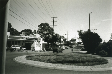 Ringwood and District Historical Society
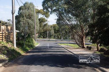
Photograph-B&W, Joan Walker, East Ringwood 2000- Roundabout in Railway Avenue cnr Wenwood Street looking West (railway line on right hand side), 2000
... Wenwood Street looking West (railway line on right hand side)... Wenwood Street looking West (railway line on right hand side)- B&W... in Railway Avenue cnr Wenwood Street looking West (railway line ...East Ringwood 2000- Roundabout in Railway Avenue cnr Wenwood Street looking West (railway line on right hand side)- B&W Photo from Album 6501 -
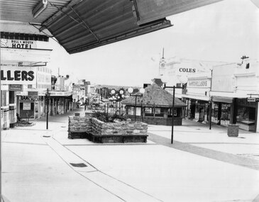 Stawell Historical Society Inc
Photograph, Main Street looking West from Fountain Area down Gold Reef Mall c1984
... Main Street looking West from Fountain Area down Gold Reef...Main Street looking West from Fountain Area down Gold Reef... grampians Main Street looking West from Fountain Area down Gold Reef ...Main Street looking West from Fountain Area down Gold Reef Mall Shows Rotunda and planter boxes. Bull and Mouth Hotel at left of photo Geo Mitchell at right. C1984stawell businesses, streetscape -
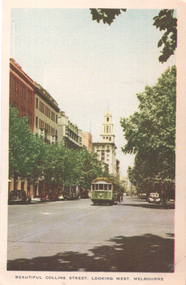 Melbourne Tram Museum
Postcard, Nucolorvue Publishing, "Beautiful Collins Street looking west Melbourne", 1930s
... "Beautiful Collins Street looking west Melbourne"...Niucolorvue postcard titled "Beautiful Collins Street... Victoria. "Beautiful Collins Street looking west Melbourne ...Niucolorvue postcard titled "Beautiful Collins Street looking west Melbourne", looking west from near Exhibition St. Has W2 class tram 532, route 44 eastbound. In the background is the T&G building.Yields information about Collins St, during the 1930s.Postcard - printed, unused, coloured, by Nucolorvue Productions, Mentone Victoria.trams, tramways, w2 class, collins st, tram 532 -
 Frankston RSL Sub Branch
Bugle, 1911
... 38 West Street, Charing Cross Road, London, United Kingdom ...The bugle was most likely used in the First World War for ceremonial and military operational functions. Bugles were an effective means of passing fixed messages and times over the noise and distance of battles and battlefields. Henry Potter & Co was a well known manufacturer of military bugles for the First World War. Copper bugle with brass trim, mouthpiece and brass retaining chain. inscribed "ANZACS" "The Great War, 1914 - 1918"world war one, ww1, brass, musical instrument, bugle, henry potter -
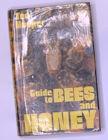 Victorian Apiarists Association
Publication, Guide to Bees and Honey (Ted Hooper), 1976
... Link House, West Street, Poole, Dorset, Great Britain ...A5 sized hard cover book. Inner cover dark brown. Outer cover sleeve has a photo of a Queen Bee surrounded by workers on the front with yellow writing. On the back is a photo of a bee collecting pollen. On the inside of the front cover is a blurb about the book, on the inside of the back cover is a list of books published by Blandford Press 260 pages -
 Melbourne Tram Museum
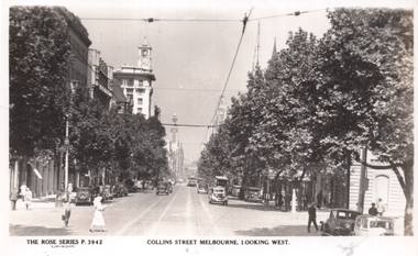
Postcard, Rose Stereograph Co, "Collins Street looking west", late 1930s
... "Collins Street looking west"... west, shows a view from Exhibition Street with several motor... west, shows a view from Exhibition Street with several motor ...Rose Series postcard No. P 3942, Collins Street looking west, shows a view from Exhibition Street with several motor cars. A W2 class tram with route number boxes is in the far distance, and some pedestrians, including a lady in a white habit or uniform. The T&G building sports its original tower as built in 1929. Yields information about Collins St. mid to late 1930s.Postcard - printed real photograph with Rose Stereograph Co. name on the rear.trams, tramways, collins st, w2 class -
 Ringwood and District Historical Society
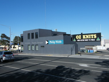
Photograph, 135 Maroondah Highway, looking south-west across Ringwood Street intersection, in 2008. Showing Philip Webb real estate, formerly the SEC
... 135 Maroondah Highway, looking south-west across Ringwood... Haines, RDHS, in 2008. 135 Maroondah Highway, looking south-west ...Photographic record by Russ Haines, RDHS, in 2008. -
 Ringwood and District Historical Society
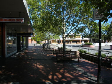
Photograph, Looking west towards Ringwood Street, in Civic Place, Ringwood in 2008, near to Midway Arcade. Showing JB Clearance Centre and Post Office across the road
... Looking west towards Ringwood Street, in Civic Place... Haines, RDHS, in 2008. Looking west towards Ringwood Street ...Photographic record by Russ Haines, RDHS, in 2008. -
 Ringwood and District Historical Society
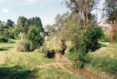
Photograph, Mullum Mullum Creek on 29th Oct 1989, north bank 100m west of Harrison Street, Unknown date
... Mullum Mullum Creek on 29th Oct 1989, north bank 100m west... Creek on 29th Oct 1989, north bank 100m west of Harrison Street ...Digital photograph -
 Eltham District Historical Society Inc
Photograph - Digital Photograph, Jim Connor, View looking west along Luck Street from near Commercial Place,. Eltham, 18 April 2018
... View looking west along Luck Street from near Commercial... - born digital View looking west along Luck Street from near ...Former McEwans the Bunnings builing on right, now Aldijim connor collection, eltham shopping centre, luck street -
 Eltham District Historical Society Inc
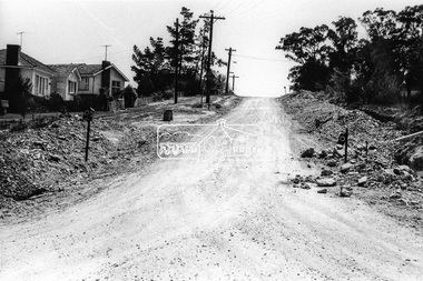
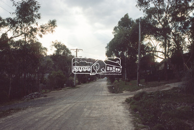
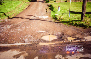
Photograph, Looking west along Bridge Street from intersection with Bible Street, Eltham, c.September 1966, 1966c
... Looking west along Bridge Street from intersection with... Looking west along Bridge Street from intersection with Bible ...Black and white photographic printOriginally located in a Filmpro King Size Prints processing envelope $3.01 Shire of Eltham 9/9/66 and noted as Calrossie Ave area and crossed out Eltham-Yarra Glen Road, Bridge Street to Elsa Court existing conditions mid 1967bible street, bridge street, road construction, streets -
 Eltham District Historical Society Inc
Photograph, Looking west along Bridge Street towards intersection with Bible Street, Eltham, c.September 1966, 1966c
... Looking west along Bridge Street towards intersection with... Looking west along Bridge Street towards intersection with Bible ...Black and white photographic printOriginally located in a Filmpro King Size Prints processing envelope $3.01 Shire of Eltham 9/9/66 and noted as Calrossie Ave area and crossed out Eltham-Yarra Glen Road, Bridge Street to Elsa Court existing conditions mid 1967bible street, bridge street, road construction, streets -
 Eltham District Historical Society Inc
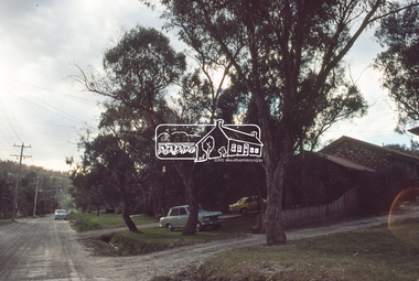
Photograph, Looking west along Brougham Street near No. 101, Eltham, c. September 1966, 1966c
... Looking west along Brougham Street near No. 101, Eltham, c... Looking west along Brougham Street near No. 101, Eltham, c ...Black and white photographic printOriginally located in a Filmpro King Size Prints processing envelope $3.01 Shire of Eltham 9/9/66 and noted as Calrossie Ave area and crossed out Eltham-Yarra Glen Road, Bridge Street to Elsa Court existing conditions mid 1967brougham steet, road construction, streets -
 Eltham District Historical Society Inc
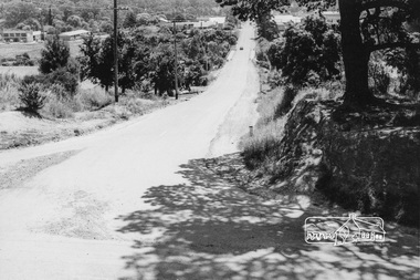
Slide, Quinn Estate looking west along Cressy Street, Montmorency, c.Oct. 1980
... Quinn Estate looking west along Cressy Street, Montmorency... Street Housing estate Infrastructure Montmorency Quinn Estate ...One of a series of images of roads and infrastructure focussed on the Quinn Estate in Montmorency taken by Eltham Shire Council Planning and Engineering officers. They provide perspective of the changes in housing styles and road development that began sweeping in from the mid 1970s with increasing urbanisation of what was once more outlying suburbs and regions.35 mm colour positive transparency Mount - Kodak Kodachrome CardProcessed Oct 1980cressy street, housing estate, infrastructure, montmorency, quinn estate, roads -
 Eltham District Historical Society Inc
Slide, Quinn Estate looking west along Cressy Street, Montmorency near no. 29, c.Oct. 1980
... Quinn Estate looking west along Cressy Street, Montmorency... Street Housing estate Infrastructure Montmorency Quinn Estate ...One of a series of images of roads and infrastructure focussed on the Quinn Estate in Montmorency taken by Eltham Shire Council Planning and Engineering officers. They provide perspective of the changes in housing styles and road development that began sweeping in from the mid 1970s with increasing urbanisation of what was once more outlying suburbs and regions.35 mm colour positive transparency Mount - Kodak Kodachrome CardProcessed Oct 1980cressy street, housing estate, infrastructure, montmorency, quinn estate, roads -
 Eltham District Historical Society Inc
Photograph, Looking west along Brougham Street, Eltham, c.1988, 1988c
... Looking west along Brougham Street, Eltham, c.1988... streets Colour photograph Looking west along Brougham Street ...Road construction works on Brougham Street prior to sealing, outside No. 21.Colour photographbrougham street, eltham, road construction, streets -
 Eltham District Historical Society Inc
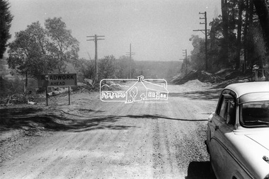
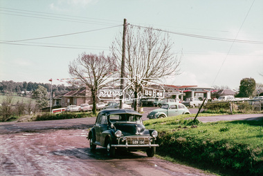
Photograph, Looking west from Brougham Street near Eltham Courthouse across Main Road, 30 August 1967, 1967
... Looking west from Brougham Street near Eltham Courthouse... - Agfacolor Service (Blue stepped) Looking west from Brougham Street ...35mm Colour positive transparency Mount - Agfacolor Service (Blue stepped)brougham steet, eltham, eltham courthouse, main road, mobil service station -
 Eltham District Historical Society Inc
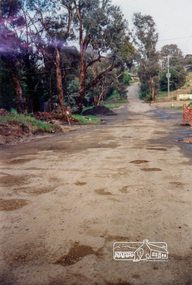
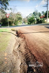
Photograph, Road surface conditions around Eltham: Looking west along Franklin Street at intersection with Bible Street, 7 Aug 1996, 1996
... Road surface conditions around Eltham: Looking west along... conditions around Eltham: Looking west along Franklin Street ...Shows sections of Franklin, John and Napoleon streets were still unmade as of late 1996 and the condition of those roads with potholes at the intersections with Bible Street.Reflects on the changing nature of the local street-scape and housesRoll of 35mm colour negative film, 7 stripsKodak Gold 100-5eltham, napoleon street, bible street, franklin street, john street -
 Eltham District Historical Society Inc
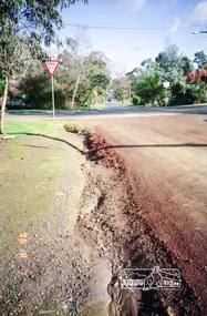
Photograph, Road surface conditions around Eltham: Looking west along John Street at the intersection with Bible Street, 7 Aug 1996, 1996
... Road surface conditions around Eltham: Looking west along... conditions around Eltham: Looking west along John Street ...Shows sections of Franklin, John and Napoleon streets were still unmade as of late 1996 and the condition of those roads with potholes at the intersections with Bible Street.Reflects on the changing nature of the local street-scape and housesRoll of 35mm colour negative film, 7 stripsKodak Gold 100-5eltham, napoleon street, bible street, franklin street, john street -
 Eltham District Historical Society Inc
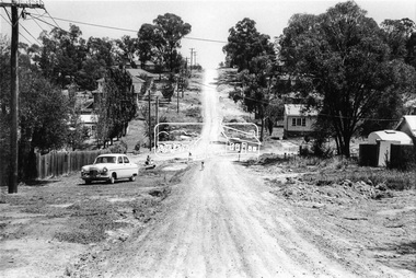
Photograph, Looking west along Bridge Street and across intersection at Main Road, Eltham, February 1968, Feb 1968
... Looking west along Bridge Street and across intersection at... Looking west along Bridge Street and across intersection at Main ...In February 1968 an unknown person took a series of photos from the Eltham Hotel at Pitt Street heading north along Main Road through the shopping centre to just north of Elsa Court covering the length of the section of Main Road which was duplicated shortly thereafter. Shows the condition and environment of the streesscape of Main Road, Eltham immediately prior to the duplication between Pitt Street and Elsa Court through the shopping centre. Also shows a number of shops and businesses that operated at that time.Black and white photographduplication, eltham, main road -
 Eltham District Historical Society Inc
Photograph, Looking west along Bridge Street, from Main Road, Eltham, February 1968, Feb 1968
... Looking west along Bridge Street, from Main Road, Eltham... and white photograph Looking west along Bridge Street, from Main ...Shows the Diamond Creek bridge and part of Susan Street In February 1968 an unknown person took a series of photos from the Eltham Hotel at Pitt Street heading north along Main Road through the shopping centre to just north of Elsa Court covering the length of the section of Main Road which was duplicated shortly thereafter. Shows the condition and environment of the streesscape of Main Road, Eltham immediately prior to the duplication between Pitt Street and Elsa Court through the shopping centre. Also shows a number of shops and businesses that operated at that time.Black and white photographduplication, eltham, main road, bridge street, susan street -
 Eltham District Historical Society Inc
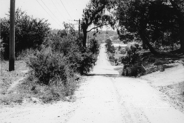
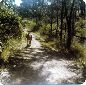
Photograph, Richard Pinn, Jah on Maroondah Aqueduct trail west of Afton Street, early 1980s, 1980s
... Jah on Maroondah Aqueduct trail west of Afton Street, early... Aqueduct trail west of Afton Street, early 1980s Photograph Richard ...Colour photographmaroondah aqueduct -
 Eltham District Historical Society Inc
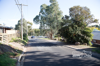
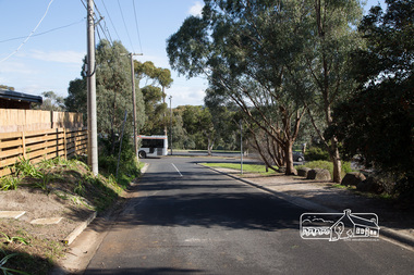
Photograph, Peter Pidgeon, Looking west along York Street, Eltham, 20 May 2017, 20 May 2017
... Looking west along York Street, Eltham, 20 May 2017... Digital Looking west along York Street, Eltham, 20 May 2017 ...Born Digitaleltham, main road, york street, le pine funeral home -
 Eltham District Historical Society Inc
Photograph, Peter Pidgeon, Looking west along York Street, Eltham, 20 May 2017, 20 May 2017
... Looking west along York Street, Eltham, 20 May 2017... Digital Looking west along York Street, Eltham, 20 May 2017 ...Born Digitaleltham, main road, york street, le pine funeral home