Showing 172 items
matching yallock
-
 Mont De Lancey
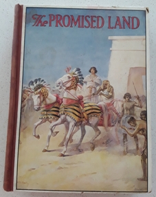
Book, Catherine Shaw et al, The Promised Land, 1928
A collection of Bible stories about The Promised Land retold by Catherine ShawHardcover children's religious instruction book, The Promised land, with picture of an Egyptian chariot race in biblical times with red lettering for title at top of illustration. Brown spine with black printed title, 6 crowns and publisher name. Black and white and coloured illustrations throughout.fictionA collection of Bible stories about The Promised Land retold by Catherine Shaw books, fiction, biblical stories, children's books -
 Linton and District Historical Society Inc
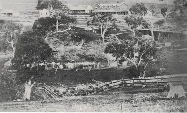
Photograph, Early Pitfield, Showing Bridge, Store and Hotel
Identified by inscription on the back of the photograph as "Early Pitfield", and the buildings as "Matthew Hamilton Baird's . . . hotel & store". Information from Joan Hunt (see 'Pitfield/Kaleno' file) says the Emu Inn or Pitfield Hotel was at Pitfield/Wardy Yallock township on the road from Skipton to Geelong. Part of this area - foreground, to the left, was called "Buncle's Flat", named after John Buncle, a carpenter who lived in a cottage there with his family. An early timber inn on the Wardy Yallock Creek was owned first by Peter Hardie and then by Edward Langhorne/John McNamara in the 1840s and a mail run from Geelong was established to it in 1846. Matthew Hamilton Baird was the lessee or owner from 1852, and Benjamin Fernald from about 1860. In 1853, the nearby store, at that time owned by William Whitecross, caught fire. The fire spread to the hotel and both buildings were destroyed. The hotel was replaced by the brick or stone building seen in the photograph.Small black and white copy of original photograph which shows trees, fencing and farm buildings in foreground, and in the background a large stone or brick building plus smaller timber buildings (dwellings?) situated along a roadway. On the right of the photograph the road goes over a large bridge of timber construction.On back of photograph: "Early Pitfield showing Matthew Hamilton Baird's store (stone?) & hotel & store".pitfield bridge, pitfield hotel, pitfield township, buncle's flat, emu inn, buildings, hotels, matthew hamilton baird, benjamin fernald, edward langhorne, john mcnamara, william whitecross -
 Mont De Lancey
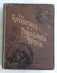
Book, Talbot Baines Reed, The Adventures of a Three Guinea Watch, c 1883
A vintage early 1800's adventure story for teenage boys with black lined illustrations. A boy is given a watch for his 13th birthday as he goes off to school. The watch narrates his own story as he changes 'owners' and travels to London, a pawn shop, a university, to the seaside, India and back to..... There are strong religious themes throughout.A vintage early 1800's brown hardcover children's book with the title The Adventures of a Three Guinea Watch printed in gold diagonal letter on the front cover with a black lined illustration of two boys playing with a fob watch sitting inside a large barrel. The spine has the title and RTS symbol for the publisher printed in gold lettering. The back cover has a black lined drawing of a boy reading a book in front of a bookcase with the heading: THE BOYS OWN BOOKSHELF printed in a banner above. There are flowers and butterflies too. The frontispiece illustration depicts a woman and a man with a boy in football clothes talking. It is covered with faded tissue paper. The title page has the title, author, publisher details and the same black lined illustration as is featured on the back cover. Throughout the book are many black lined illustrations. At the back is page of further Books for Boys published by The Religious Tract Society. The author,Talbot Baines Reed wrote school stories for boys. Pp. 226.fictionA vintage early 1800's adventure story for teenage boys with black lined illustrations. A boy is given a watch for his 13th birthday as he goes off to school. The watch narrates his own story as he changes 'owners' and travels to London, a pawn shop, a university, to the seaside, India and back to..... There are strong religious themes throughout.children's books, books, children's stories, adventure stories, teenage stories, boys' stories -
 Mont De Lancey
Book, A.J. Downing et al, The Fruits and Fruit-Trees of America, 1890
A textbook about the Fruits and Fruit-Trees of America; The Culture, Propagation, and Management, in the Garden and Orchard, of Fruit Trees generally; with descriptions of all the finest varieties of fruit, native and foreign , cultivated in this country.A large homemade green cloth covered book, The Fruits and fruit-Trees of America by A.J. Downing, Second Edition by Charles Downing. It has diagrams and outline drawings of fruit, native and foreign cultivated in America. A section at the back is headed - Key to French Names. An Index to the Different Fruits is included along with a General Index. Appendixes I, II and III has a General Index with synonymous names in Italic. Tanning, foxing and stains are noted. 1098p. plus 193p. for Appendixes.non-fictionA textbook about the Fruits and Fruit-Trees of America; The Culture, Propagation, and Management, in the Garden and Orchard, of Fruit Trees generally; with descriptions of all the finest varieties of fruit, native and foreign , cultivated in this country.horticulture, agriculture, fruit growing -
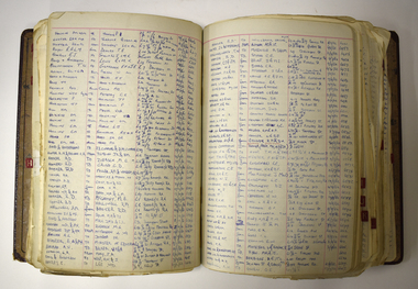 Warrnambool and District Historical Society Inc.
Administrative record - Store Keeper's Ledger, John Stewart Store keeper, 1890-1905
This ledger is a record of the sales of John Stewart from 1890 to 1905 in the districts of Warrnambool, Garvoc, Hamilton and Horsham. John Stewart was a printer and store keeper in Warrnambool from 1890 to 1895. He was also connected to several hotels in the district- the Pieter Both Hotel in Warrnambool in Raglan Parade, ( his wife was the Licensee in 1897), the Yallock Inn in Garvoc ( his wife was the licensee 1899), and hotels in Hamilton and Horsham.The Ledger is of some interest as it contains the names of many local people at the end of the 19th Century. It is a handy research tool. This ledger has 542 pages. It has a hard cover with a dark green cloth cover with leather binding on the spine and corners of the cover. There is a red label on the spine with gold printing and patterning. The inside of the cover has a mottled pattern. There is an alphabetical index at the front. The pages have red ruled lines and hand written entries in ink. John Stewart the original Owner of this book was beside being Printer & Storekeeper in Warrnambool 1890-1895 was Licensee of Peter (sic) Both Hotel -Warrnambool 1895 Garvoc Hotel Garvoc 1899 Caledonian Hotel Hamilton 1902 Criterion Hotel Horsham 1904 Farmers Union Hotel Horsham 1905 Presented to The City of Warrnambool April 1969 by his Son Roy A Stewart Written by J. Stewart's Grandson Bryce A Carter 13th April 1969john stewart printer and store keeper, pieter both hotel, garvoc hotel -
 Mont De Lancey
Book, W.f. Morris, Bretherton: Khaki or Field-Grey?, 1929 - (reprint 1935)
A tale of mystery and identity, first published in 1929 is an account of the brutal conditions at the battlefront in WW1 between English and German soldiers. It is an espionage thriller with a twisting and unusual plot with the English soldier G Bretherton as the main character.Green hardcover book for boys, with the title Bretherton Khaki or Field-Grey? by W.F. Morris as well as the publisher Geoffrey Bles printed in black lettering with the symbol of a bird. 319p. 319p.fictionA tale of mystery and identity, first published in 1929 is an account of the brutal conditions at the battlefront in WW1 between English and German soldiers. It is an espionage thriller with a twisting and unusual plot with the English soldier G Bretherton as the main character.war fiction, romance fiction, spies fiction -
 Mont De Lancey
Book, J.D. Morell, M.A., LL.D, A Grammar of the English Language, c1861
Written by an Inspector of Schools, this book approaches grammar from logic principles, with the stated aim to be clear and brief so as not to confuse the young scholar.A dark green homemade hardcover book, title - A Grammar of the English language together with an exposition of The Analysis of Sentences by J.D.Morell, M.A., LL.D. It has tables, lists, exercises as well as an appendix. 130p. plus an appendix of 63p. pencil and ink markings throughout. Foxing, stains and discoloration noted.non-fictionWritten by an Inspector of Schools, this book approaches grammar from logic principles, with the stated aim to be clear and brief so as not to confuse the young scholar.education, english, grammar -
 Mont De Lancey
Book, W. Fream, LL.D, Elements of Agriculture A Textbook, 1892
An English textbook for elementary work on Agriculture adapted for use in rural and other schools and classes.A plain blue hardcover textbook, Elements of Agriculture by W. Fream, LL.D. The spine has the title, author symbol for The Royal Agricultural Society of England, price 2/6 and the publisher John Murray written in gold lettering. it has three parts to the contents, the soil, the plant and the animal along with an Index of plants and a general index. At the back there are listed pamphlets published by the Society and books relevant to the topic. Diagrams, illustrations, tables and charts are included. 450p.non-fictionAn English textbook for elementary work on Agriculture adapted for use in rural and other schools and classes.agriculture, farming -
 Mont De Lancey
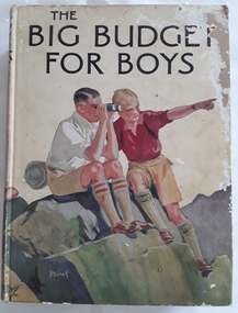
Book, Blackie and Son Limited, The Big Budget for Boys, c1930's
Book read by family members, especially Lance Sebire who was awarded it from Sunday School in 1936Large hardcover children's book for boys with coloured picture on front cover of two boys sitting on a rock, one looking through binoculars and the other pointing into the distance. The title, The Big Budget for Boys is printed in black lettering on the front and spine with an illustration of another boy and the publisher. The back cover is also illustrated in colour with two more boys reading a map. The collection of adventure stories have black and white illustrations throughout.Mrs Les Gaudion's Class - Methodist Sabbath School Wandin Yallock. Awarded to Lance Sebire for Diligence and Attendance. Mr J H Lord Supt. Harold Blanksby Sec. May 18th 1936. The Book Depot, 288 Little Collins Street (Methodist Book Buildings)adventure, young people's fiction, children's fiction, children's book -
 Melbourne Tram Museum
Photograph - Photo card Melbourne album sheets 1920c
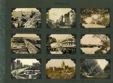
Part of an album of photo cards - cigarette card size - that depicted Melbourne and other country towns c1920. Sheet 1 - Melbourne - Elizabeth St, Collins St, Spring St, St Kilda Rd, Swanston St, Princes Bridge and Exhibition buildings. Sheet 2 - Healesville, Lorne, Brighton, Albury, Bendigo, Woori Yallock and Queenscliff - three cards have been removed prior to acquisition. Sheet 3 - Queen Victoria Gardens, Alexandra Avenue, Exhibition Gardens, St Kilda Road, Botanic Gardens - three cards have been removed prior to acquisition.Set of three album sheets containing up to 9 small printed photos on each sheet of Melbourne and some country towns.melbourne, victoria, tramways, gardens -
 Warrnambool and District Historical Society Inc.
Functional object - Farming Equipment Branding Iron, Circa 1840
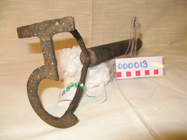
Armyne, George and Lemuel Bolden were original landholders of large parts of land in the Western district. Portions of it extended from Pirron Yallock in the East to almost as far as Portland. The head station was at Grasmere. They were noted breeders of shorthorn cattle in fact they were some of the first men to bring the breed to Victoria and thus helped to pioneer the Australian Shorthorn breeding Industry. This branding iron was found at Lyall Park, originally 640 acres selected by William Lyall at Cooramook. It is believed to be a branding iron dating from when the land was occupied by the Bolden Brothers. The Bolden Brothers were the first to erect considerable lengths of fencing in the Warrnambool area. If this item is an authentic Bolden piece of property then it is the oldest artefact from the time of white settlement that is held by the Warrnambool and district Historical society. The item itself while a common farming implement and which was found on a farm originally owned by the Bolden Brothers is a link with the earliest part of Warrnambool’s history.Short, round wooden handle with metal brand in the shape of the letter T with two thirds circle attached to vertical part of T. Daub of paint at end of handle . T 5Paper label attached with green tape with 931 in texta and hand written on back,” branding iron reputed to have been used by Bolden Bros Grasmere c 1840. warrnambool, bolden brothers, armyne bolden, george bolden, lemuel bolden, branding iron, shorthorn cattle -
 Eltham District Historical Society Inc
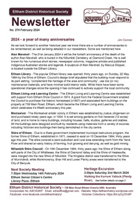
Journal - Newsletter, Newsletter, No. 274 February 2024
Contents: • 2024 – a year of many anniversaries by Jim Connor • Our Next Meeting - 7.30pm Wednesday 14th February 2024 • Heritage Excursion - Saturday 2nd March 2024 – Walking the Kurrum Yallock (Plenty River) • The beginning of Local Government in Eltham by Jim Connor • Alan Marshall – An Anniversary by Jim Connor • Book Review – Michael Wilson, Eltham Goldsmith and Sculptor – My Journey • Montsalvat People by Richard Pinn o Justus Jorgensen (1893-1975) o Betty Roland (1903-1996) • Two Eltham Women Served in WW1 by Terry Beaton • Brief Comparison Between WW1 and WW2 by Terry Beaton • Recollections of Marcus Skipper • Eltham Cemetery Stories by Liz Pidgeon o Lena Cooper Skipper, nee Wilshire, 1889-1970, Painter and Montsalvat Founder • Experience Eltham Cemetery: The founding members by Julia Drew The Shire of Eltham Historical Society was formed in October 1967. The first newsletter of the Society was issued May 1978 and has been published continuously ever since on a bi-monthly basis. With the cessation of the Shire of Eltham in late 1994, the Society's name was revised to Eltham District Historical Society and this name first appeared with issue No. 103, July 1995. The collection of the Society's newsletters provides a valuable resource on the history of the Society's activities, office bearers and committee members, guest speakers and subjects of historical interest pertinent to the former Shire of Eltham and the Eltham District.A4 newsletter distributed to members (Digital and A4 photocopy)newsletter, eltham district historical society -
 City of Kingston
Photograph - Colour, Paul Tresize, 1998
The name Mordialloc was derived from the name Moody Yallock, which comes from the Bunurong language. The Bunurong Peoples are the Traditional Owners of this area. The name means “high water” or “high creek”. In 1839, colonial authorities declared the mouth of the creek, and an additional 830 odd acres as an Aboriginal Reserve, although this proclamation was never gazetted. The reserved land included part of the Carrum Carrum Swamp which was abundant with wild life and natural resources. Regular encroachments, including land sales which began in 1863, were made on the land until 1878 when the Reserve was declared closed, and the land was opened up to land sales. Market gardening and suburban house lots quickly began to develop, and Mordialloc became a renowned picnic and holiday site. Mordialloc Creek is a popular bay side destination for local and visitors, and is a site for boating, kayaking, fishing and swimming, along with many other activities.Colour photograph of Mordialloc Creek, looking out to the bay. Many small fishing and leisure craft are moored on either side of the banks of the creek. To the right hand side can be seen parklands, while the left hand side has a small inlet in which more small crafts are moored.mordialloc, bunurong, traditional owners, suburbs, boats, fishing, waterways -
 City of Kingston
Photograph - Colour, 1998
The name Mordialloc was derived from the name Moody Yallock, which comes from the Bunurong language. The Bunurong Peoples are the Traditional Owners of this area. The name means “high water” or “high creek”. In 1839, colonial authorities declared the mouth of the creek, and an additional 830 odd acres as an Aboriginal Reserve, although this proclamation was never gazetted. The reserved land included part of the Carrum Carrum Swamp which was abundant with wild life and natural resources. Regular encroachments, including land sales which began in 1863, were made on the land until 1878 when the Reserve was declared closed, and the land was opened up to land sales. Market gardening and suburban house lots quickly began to develop, and Mordialloc became a renowned picnic and holiday site. Mordialloc Creek is a popular bay side destination for local and visitors, and is a site for boating, kayaking, fishing and swimming, along with many other activities.Colour photograph of Mordialloc Creek, looking inland.Small fishing and leisure boats are moored on either side of creek, with a view of the Mordialloc Bridge Hotel in the background.mordialloc, bunurong, traditional owners, suburbs, boats, fishing, waterways, hotel -
 City of Kingston
Photograph - Colour, Paul Tresize, 1998
The name Mordialloc was derived from the name Moody Yallock, which comes from the Bunurong language. The Bunurong Peoples are the Traditional Owners of this area. The name means “high water” or “high creek”. In 1839, colonial authorities declared the mouth of the creek, and an additional 830 odd acres as an Aboriginal Reserve, although this proclamation was never gazetted. The reserved land included part of the Carrum Carrum Swamp which was abundant with wild life and natural resources. Regular encroachments, including land sales which began in 1863, were made on the land until 1878 when the Reserve was declared closed, and the land was opened up to land sales. Market gardening and suburban house lots quickly began to develop, and Mordialloc became a renowned picnic and holiday site. Mordialloc Creek is a popular bay side destination for local and visitors, and is a site for boating, kayaking, fishing and swimming, along with many other activities.Colour photograph of Mordialloc Creek, looking inland. Boats are moored on either side of the creek and the Bridge Hotel is visible in the background.mordialloc, bunurong, traditional owners, suburbs, boats, fishing, waterways, hotel -
 City of Kingston
Photograph - Colour, Paul Tresize, 1998
The name Mordialloc was derived from the name Moody Yallock, which comes from the Bunurong language. The Bunurong Peoples are the Traditional Owners of this area. The name means “high water” or “high creek”. In 1839, colonial authorities declared the mouth of the creek, and an additional 830 odd acres as an Aboriginal Reserve, although this proclamation was never gazetted. The reserved land included part of the Carrum Carrum Swamp which was abundant with wild life and natural resources. Regular encroachments, including land sales which began in 1863, were made on the land until 1878 when the Reserve was declared closed, and the land was opened up to land sales. Market gardening and suburban house lots quickly began to develop, and Mordialloc became a renowned picnic and holiday site. Mordialloc Creek is a popular bay side destination for local and visitors, and is a site for boating, kayaking, fishing and swimming, along with many other activities.Colour photograph of Mordialloc Creek with boats moored on both sides of the street and Pompei's boat yard visible on the right hand side of the creek., Main Street and St Brigid's Catholic Church are visible in backgroundmordialloc, bunurong, traditional owners, suburbs, boats, fishing, waterways, hotel, church -
City of Kingston
Photograph - Colour, Paul Tresize, 1998
The name Mordialloc was derived from the name Moody Yallock, which comes from the Bunurong language. The Bunurong Peoples are the Traditional Owners of this area. The name means “high water” or “high creek”. In 1839, colonial authorities declared the mouth of the creek, and an additional 830 odd acres as an Aboriginal Reserve, although this proclamation was never gazetted. The reserved land included part of the Carrum Carrum Swamp which was abundant with wild life and natural resources. Regular encroachments, including land sales which began in 1863, were made on the land until 1878 when the Reserve was declared closed, and the land was opened up to land sales. Market gardening and suburban house lots quickly began to develop, and Mordialloc became a renowned picnic and holiday site. Mordialloc Creek is a popular bay side destination for local and visitors, and is a site for boating, kayaking, fishing and swimming, along with many other activities.Colour photograph of Mordialloc Creek with boats moored on both sides of the street and Pompei's boat yard visible on the right hand side of the creek., Main Street and St Brigid's Catholic Church are visible in background.mordialloc, bunurong, traditional owners, boats, fishing -
 Mont De Lancey
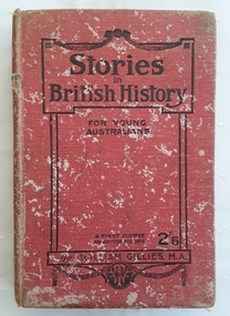
Book, William Gillies, M.A, Stories in British History for Young Australians, 1920
A simple study in British History for secondary school students with a fold out map of the British Empire at the time - published in 1920. There is a list of the dynasties and kings and queens and a table of Periods in British History which can be referred to.A badly damaged red cloth covered hardcover book with the title: Stories in British History for Young Australians printed in black lettering on the front cover with the publisher, a round publisher symbol and 2/6 at the bottom. The title is printed on the spine. This is a First Course in British History by William Gillies, M.A. Inside, opposite the title page, is a lined sketch of Oliver Cromwell. Black white illustrations, maps and photographs are included. At the back is an Index as well as three additional recommended titles of other history books. Considerable markings, lists and a love poem is scribbled at the back. It is quite damaged and worn through use. Pp.315.non-fictionA simple study in British History for secondary school students with a fold out map of the British Empire at the time - published in 1920. There is a list of the dynasties and kings and queens and a table of Periods in British History which can be referred to.great britain - history, history, textbooks -
 Eltham District Historical Society Inc
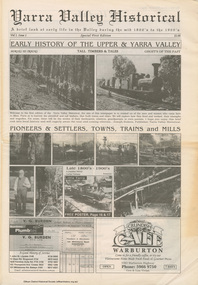
Work on paper (item) - Newspaper, Joseph Dubois, Yarra Valley Historical: a brief look at early life in the Valley during the mid 1800's to the 1900's
Volume 1, Issue 1. Early History of the Upper and Yarra Valley. "Welcome to the fist edition of the Yarra Valley historical, the aim of this newspaper is to remind us of the men and women who came here to mine, farm or harvest the plentiful and tall timbers, that built towns and cities..." Estimated date of publication 2010. The newspaper is full of potted histories of places with historical photographs, maps and timelines. Acknowledgment and citations for source material given. Advertisements for business's at the time of publicaion. Lilydale, De Castella family, p2. Mount Evelyn p6. Wandin [Anker family] p7. Seville [William Henry Smith; Mr and Mrs Thomas Payne; Duck family; Chandler family] p8. Woori Yallock p10. Yellingbo p11. Hoddles Creek p12. Launching Place p13. Yarra Junction p14. Reminiscences of Don 'Ripper' Reid p18. Wesburn p20. Warburton Village Settlement p22. Warburton p23. Big Pats Creek p26. McMahons Creek / Reefton [Brimbonga School] p27. Gladysdale / Gilderoy [Saxton family] p28. Powelltown p30.lilydale, mt evelyn, wandin, seville, woori yallock, yellingbo, hoddles creek, launching place, yarra junction, don reid, reminiscences, wesburn, warburton, big pats creek, mcmahons creek, reefton, gladysdale, gilderoy, powelltown, newspaper -
 Otway Districts Historical Society
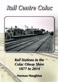
Book, Norman Houghton, Rail Centre Colac, 2014
Colac was the centre of a spidery rail network over which were carted anything and everything by Victorian Railways, the common carrier throughout the area. The main line through the region was the 35 km rail route from Birregurra (and thence to Geelong) though Colac to Pirron Yallock (and thence to Warrnambool and Port Fairy) from March, 1877, to July, 1883. The first branch line ran from Irrewarra to Beeac in 1889, which then extended in stages to Cressy and on the Ballarat. The second branch line was the 31 km long Birregurra to Forrest in 1891. The cost of building railways into mountainous terrain meant the third branch line was a narrow-gauge 2 foot 6 inch line, first of all to Beech Forest in 1902, and then to Crowes in 1911, for a total of 71 km. The final rail connection was the 16 km branch from Colac to Alvie to facilitate the transport of onions, opening in 1923. Each line had its own character and peculiarities derived from its foundation, geography and economic base. As a general rule, the loadings on the branch lines had greater output tonnage than inwards, the reverse of the main line. The lines traversed agricultural and timber areas where inputs like seed, grass, fertiliser and labour were minor, compared with the output, timber, wool, cream, butter, cheese fruit, potatoes, onion, grain and livestock.Rail Centre Colac. Rail stations in the Colac Otway Shire, 1877 to 2014. Norman Houghton. 1st ed. Norman Houghton; Geelong (Vic); 2014. vi, 262 p.; illus., maps, index. Soft cover.colac; cressy; forrest; beech forest; crowes -
 Surrey Hills Historical Society Collection
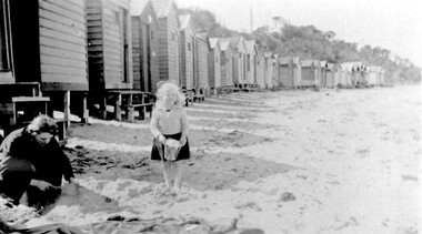
Photograph, Beatrice Mary Stalker, later Mrs Howard Breedon Everard, at the beach, 1930s
Mary Stalker’s engagement notice in The Argus in July 1947 indicates that she was the youngest daughter of Mr & Mrs A M Stalker of Montlare [Monclair] Avenue, North Brighton. It announces her engagement to ”Cr Howard Breedon Everard JP Ev-Ron, Woori Yallock, Youngest son of Hon WH Everard Wellington St Kew and the late Mrs Everard.” Beatrice Mary Stalker was born in 1919. Her parents were Alexander MacLaren Stalker (1885-1970/1973) and Charlotte Eleanor Hayward (1884-1953) who were married in 1911. Her sisters were Joan Winnock Stalker, Betty Neil Stalker and Ruth McLaren Stalker. Charlotte was a teacher prior to her marriage. Alexander, an accountant, lived in Wattle Valley Road, Canterbury in 1910. From 1912-1931 they are listed at ‘Benwerrin’, Wandsworth Road, Surrey Hills. Mary Stalker married in 1949 and by 1954 she and Howard were living at 44 Wandsworth Road, Surrey Hills, which was their home for decades. Howard was born in 1914 and died in October 2010: "EVERARD. - Howard Breedon. In loving memory of Howard, who lived life to the full to the very end of his 96 years. Greatly loved and honoured by Mary, Rosemary, David, Elizabeth, John and extended families." Beatrice Mary Everard died on 25 September 2019, aged 93. it is assumed that the woman in the photo is Mary's mother, Charlotte Eleanor Stalker (nee Hayward). The photo taken at the beach in 1930's may have been at Brighton, given the family’s later association with the suburb. This photo documents part of the social history of a family with a long and strong association with Surrey Hills. The backdrop of the typical bathing boxes used for changing into swimsuits, for lunch and for storing sports and beach gear, documents beach recreation and culture of the 1930s. Given the family's later residence in Brighton, this may well have been taken at Brighton Beach. For many years in the late nineteenth century, Brighton was Melbourne's favourite seaside destination. The now iconic bathing boxes were a response to Victorian ideas of morality and sea bathing. There are 82 Brighton bathing boxes, which protected by a heritage overlay because of their uniform scale and proportion, building materials, sentry order alignment. All retain their classic Victorian architectural features with timber framing, weatherboards and corrugated iron roofs. They remain as they did over one hundred years ago, as licensed bathing boxes. Service amenities such as electricity or water were never connected.A black and white photograph of a lady and little girl on the beach. There is a row of bathing boxes behind them.(miss) mary stalker, bathing boxes, (mrs) mary everard, (miss beatrice mary stalker, (mrs) beatrice mary everard, (mrs) charlotte eleanor stalker, (miss) charlotte eleanor hayward -
 Eltham District Historical Society Inc
Photograph, Fay Bridge, Footbridge, Fort Knox Self Storage, 197 Sherbourne Road, Eltham, n.d
The footbridge which extended from the facility to the landscaped garden and water features is now gone. The footbridge and garden were previously part of a former hat factory in Sherbourne Road Eltham which has in the past been used for various purposes and presently a self storage business. The Karingal Yallock Creek passes through the front of the land and the creek environs are the subject of significant and unusual landscaping works, including some cascading water channels. Some of the landscaping was damaged by the Christmas Day floods of 2011, but the main elements remain intact. The landscaped area (as distinct from the factory itself) is the subject of a Heritage Overlay under the Nillumbik Planning Scheme. The basis of this overlay is a Heritage Report by Graeme Butler and Associates in 2006. As well as an assessment of the landscaped area, it includes one background information on the history of the site (although a complete history would require more research). The site was part of Crown Portion 3 of the Parish of Nillumbik that remained as the Montmorency Farm until early in the twentieth century. The 1911 subdivision of this farm created Lot 7 of some seven acres, which is the site of this factory. The Heritage Report lists the various owners of the site. From the rate records and aerial photos it is concluded that the site was used as an orchard and farmland until the 1940s. William F Crellin, orchardist, owned the site from 1912 to 1923. Then Edmund Williams owned it until 1951. In 1955 the site was owned by Rupert V. Kirsch and this is the name anecdotally associated with the hat factory, where the well-known brand of Fayrefield Hats were manufactured. There is some belief that this was built about the time of the Second World War and that hats for the armed forces were made there.fay bridge collection, eltham, fayrefield hat factory, foot bridge, sherbourne road, footbridge, fort knox eltham -
 Eltham District Historical Society Inc
Photograph, Upper Yarra Dam, Spring Tour, 22 Oct 1995, 22/10/1995
EXPLORING THE UPPER YARRA (Newsletter No. 105, November 1995, by Bettina Woodburn) We enjoyed the Spring Excursion, this year "Exploring the Upper Yarra" - in spite of the constant rain and the countryside under the cloud cover, especially in the valleys, being mainly shiny shades of green. The occasional fields of buttercups, clumps of arum lilies and splendid rhododendron and other flowering bushes became very special. The Cobb and Co coach was warm and a cosy retreat as we zig-zagged on the highways and byways to glimpse the Yarra River, upstream and down, its secret places, and particularly the many bridges. Russell excelled as 'Poet Laureate', reading from Dacre Smyth's book. This 1979 publication includes paintings of all the bridges along the river with poems and brief descriptions of each one. Some of the bridges are in out of the way places and are not very well known. We looked forward to hearing the poetry as much as seeing the ' constructions'…Big Pat (was he short or tall, lean or fat? He did win the two hundred pound reward for discovering gold and had the creek named after him), about the 'Eddies'?, and the disliked 'meccano' bridge in Warburton, etc. etc. The hot roast lunch in the old Reefton Hotel was also most welcome. It was easy to imagine it peopled by miners and early settlers. Starting by crossing the new (1974) concrete bridge at Warrandyte we headed through Wonga Park with views to the Christmas Hills and to the escarpment of the Yering Gorge, which causes flood waters to back up through the Yarra Glen plain, so avoiding disasters downstream. At the end of a long driveway we found the wooden, privately owned Henley Bridge (1935 after the 1934 floods). This facilitates access to different parts of Henley Farm and to Lilydale. Everard Park, named after Blanche Shallard's father, a State Member for 17 years, below the Highway Yarra crossing was in need of care. It is 10 miles from Yarra Glen by road but, as "Yarra Marra” canoeists well know, 32 winding miles down by water. After more delightful countryside scenes we joined the Warburton Highway at Woori Yallock. From the old Railway Station at Launching Place the Centennial Trail for walkers, cyclists and ' horse riders has replaced the rails. The line from Lilydale was opened in 1901, and the last diesel freight train ran to Warburton in 1965. It continued to rain as we had morning tea in Warburton in a shelter between footbridges. From here we continued upstream past the Bridge to O'Shannasy Lodge and Reservoir, Starvation Creek, and the Peninsular tunnel (miners dug it as at Pound Bend) which we visited (scrambling down those steps!) on our return after lunch. Our furthermost point was the Upper Yarra Dam Reserve (and vast catchment area). Finished in 1957 after ten years work and 100 years after Yan Yean, it supplies much of Melbourne's water. After crossing the 30m Launching Place Bridge to the Eltham side of the Yarra and Healesville, we saw in the distance the Yarra Glen Timber Trestle Bridge over the river flats "the longest for years in the land it was said!" Harry's dream of "better weather over the Divide" unfortunately didn't come true, but I'm sure we 36 members will retain happy memories of a day that was wet and green and filled with Bridges. Bettina Woodburn - October 1995 Record of the Society's history of activities - Spring 1995 excursionColour photographshire of eltham historical society, activities, upper yarra dam, henley bridge -
 Eltham District Historical Society Inc
Photograph, Upper Yarra Dam, Spring Tour, 22 Oct 1995, 22/10/1995
EXPLORING THE UPPER YARRA (Newsletter No. 105, November 1995, by Bettina Woodburn) We enjoyed the Spring Excursion, this year "Exploring the Upper Yarra" - in spite of the constant rain and the countryside under the cloud cover, especially in the valleys, being mainly shiny shades of green. The occasional fields of buttercups, clumps of arum lilies and splendid rhododendron and other flowering bushes became very special. The Cobb and Co coach was warm and a cosy retreat as we zig-zagged on the highways and byways to glimpse the Yarra River, upstream and down, its secret places, and particularly the many bridges. Russell excelled as 'Poet Laureate', reading from Dacre Smyth's book. This 1979 publication includes paintings of all the bridges along the river with poems and brief descriptions of each one. Some of the bridges are in out of the way places and are not very well known. We looked forward to hearing the poetry as much as seeing the ' constructions'…Big Pat (was he short or tall, lean or fat? He did win the two hundred pound reward for discovering gold and had the creek named after him), about the 'Eddies'?, and the disliked 'meccano' bridge in Warburton, etc. etc. The hot roast lunch in the old Reefton Hotel was also most welcome. It was easy to imagine it peopled by miners and early settlers. Starting by crossing the new (1974) concrete bridge at Warrandyte we headed through Wonga Park with views to the Christmas Hills and to the escarpment of the Yering Gorge, which causes flood waters to back up through the Yarra Glen plain, so avoiding disasters downstream. At the end of a long driveway we found the wooden, privately owned Henley Bridge (1935 after the 1934 floods). This facilitates access to different parts of Henley Farm and to Lilydale. Everard Park, named after Blanche Shallard's father, a State Member for 17 years, below the Highway Yarra crossing was in need of care. It is 10 miles from Yarra Glen by road but, as "Yarra Marra” canoeists well know, 32 winding miles down by water. After more delightful countryside scenes we joined the Warburton Highway at Woori Yallock. From the old Railway Station at Launching Place the Centennial Trail for walkers, cyclists and ' horse riders has replaced the rails. The line from Lilydale was opened in 1901, and the last diesel freight train ran to Warburton in 1965. It continued to rain as we had morning tea in Warburton in a shelter between footbridges. From here we continued upstream past the Bridge to O'Shannasy Lodge and Reservoir, Starvation Creek, and the Peninsular tunnel (miners dug it as at Pound Bend) which we visited (scrambling down those steps!) on our return after lunch. Our furthermost point was the Upper Yarra Dam Reserve (and vast catchment area). Finished in 1957 after ten years work and 100 years after Yan Yean, it supplies much of Melbourne's water. After crossing the 30m Launching Place Bridge to the Eltham side of the Yarra and Healesville, we saw in the distance the Yarra Glen Timber Trestle Bridge over the river flats "the longest for years in the land it was said!" Harry's dream of "better weather over the Divide" unfortunately didn't come true, but I'm sure we 36 members will retain happy memories of a day that was wet and green and filled with Bridges. Bettina Woodburn - October 1995 Record of the Society's history of activities - Spring 1995 excursionRoll of 35mm colour negative film, 3 stripsKodak Gold 200-4shire of eltham historical society, activities, upper yarra dam, henley bridge -
 Eltham District Historical Society Inc
Photograph, Upper Yarra Dam, Spring Tour, 22 Oct 1995, 22/10/1995
EXPLORING THE UPPER YARRA (Newsletter No. 105, November 1995, by Bettina Woodburn) We enjoyed the Spring Excursion, this year "Exploring the Upper Yarra" - in spite of the constant rain and the countryside under the cloud cover, especially in the valleys, being mainly shiny shades of green. The occasional fields of buttercups, clumps of arum lilies and splendid rhododendron and other flowering bushes became very special. The Cobb and Co coach was warm and a cosy retreat as we zig-zagged on the highways and byways to glimpse the Yarra River, upstream and down, its secret places, and particularly the many bridges. Russell excelled as 'Poet Laureate', reading from Dacre Smyth's book. This 1979 publication includes paintings of all the bridges along the river with poems and brief descriptions of each one. Some of the bridges are in out of the way places and are not very well known. We looked forward to hearing the poetry as much as seeing the ' constructions'…Big Pat (was he short or tall, lean or fat? He did win the two hundred pound reward for discovering gold and had the creek named after him), about the 'Eddies'?, and the disliked 'meccano' bridge in Warburton, etc. etc. The hot roast lunch in the old Reefton Hotel was also most welcome. It was easy to imagine it peopled by miners and early settlers. Starting by crossing the new (1974) concrete bridge at Warrandyte we headed through Wonga Park with views to the Christmas Hills and to the escarpment of the Yering Gorge, which causes flood waters to back up through the Yarra Glen plain, so avoiding disasters downstream. At the end of a long driveway we found the wooden, privately owned Henley Bridge (1935 after the 1934 floods). This facilitates access to different parts of Henley Farm and to Lilydale. Everard Park, named after Blanche Shallard's father, a State Member for 17 years, below the Highway Yarra crossing was in need of care. It is 10 miles from Yarra Glen by road but, as "Yarra Marra” canoeists well know, 32 winding miles down by water. After more delightful countryside scenes we joined the Warburton Highway at Woori Yallock. From the old Railway Station at Launching Place the Centennial Trail for walkers, cyclists and ' horse riders has replaced the rails. The line from Lilydale was opened in 1901, and the last diesel freight train ran to Warburton in 1965. It continued to rain as we had morning tea in Warburton in a shelter between footbridges. From here we continued upstream past the Bridge to O'Shannasy Lodge and Reservoir, Starvation Creek, and the Peninsular tunnel (miners dug it as at Pound Bend) which we visited (scrambling down those steps!) on our return after lunch. Our furthermost point was the Upper Yarra Dam Reserve (and vast catchment area). Finished in 1957 after ten years work and 100 years after Yan Yean, it supplies much of Melbourne's water. After crossing the 30m Launching Place Bridge to the Eltham side of the Yarra and Healesville, we saw in the distance the Yarra Glen Timber Trestle Bridge over the river flats "the longest for years in the land it was said!" Harry's dream of "better weather over the Divide" unfortunately didn't come true, but I'm sure we 36 members will retain happy memories of a day that was wet and green and filled with Bridges. Bettina Woodburn - October 1995 Record of the Society's history of activities - Spring 1995 excursionRoll of 35mm colour negative film, 2 stripsKodak Gold 100-4shire of eltham historical society, activities, upper yarra dam, henley bridge