Showing 183 items
matching yarra street (kew)
-
 Kew Historical Society Inc
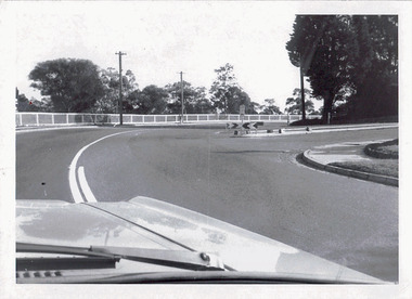
Photograph - Boulevard at Molesworth Street, c.1980
... of kew Yarra boulevard molesworth street "BOULEVARD AT MOLESWORTH ...One of a series of photographs donated by the City Engineer of the former City of Kew, relating to road works and rubbish removal.One of a series of photographs of core local government services as practised by the City of Kew. The photographs are an accurate record of council works of the period.Original black and white photographic of the Yarra Boulevard near the corner of Molesworth Street, Kew"BOULEVARD AT MOLESWORTH ST"city of kew, local government -- city of kew, yarra boulevard, molesworth street -
 Kew Historical Society Inc
Photograph - Macauley's, Kew, 1924
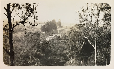
Henry Beater Christian (1886-1962) , was a descendant of one of the earliest settler families in Kew. Employed at the Kew Asylum as a 'public servant', he was a skilled amateur photographer, photographing numerous scenes in Kew and on his travels around Victoria. The majority of his photographs date from 1916 to 1929. His finest photographs are housed in two photograph albums. A very rare, early panoramic view of Macauley's boat house on the Yarra River at Kew.Digital copy of a photograph from page 2 of the 47-page photograph album containing 261 gelatinous silver images, loaned by Diane Washfold with permission given to digitise and hold a copy in our collection. The photograph is of Macauley's boat sheds on the Yarra River at Kew. The boat sheds was located at the west end of Molesworth Street. The photograph is taken from the Yarra Bend Park side of the river looking down on the boat house from above. The canoes belonging to Macauley's are lined up on the river bank. "Macauley’s Kew"henry beater christian (1886-1962), landscape photography, kew (vic.) — yarra river, christian-washfold collection, photograph albums, macauley's boat sheds -
 Kew Historical Society Inc
Photograph - Macauley's, Kew, 1924
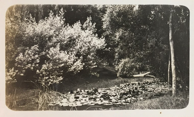
Henry Beater Christian (1886-1962) , was a descendant of one of the earliest settler families in Kew. Employed at the Kew Asylum as a 'public servant', he was a skilled amateur photographer, photographing numerous scenes in Kew and on his travels around Victoria. The majority of his photographs date from 1916 to 1929. His finest photographs are housed in two photograph albums. Digital copy of a photograph from page 2 of the 47-page photograph album containing 261 gelatinous silver images, loaned by Diane Washfold with permission given to digitise and hold a copy in our collection. The photograph is of waterlilies planted at Macauley's boat sheds on the Yarra River at Kew. The boat sheds were located at the west end of Molesworth Street. "Macauley’s Kew"henry beater christian (1886-1962), landscape photography, kew (vic.) — yarra river, christian-washfold collection, photograph albums, macauley's boat sheds -
 Kew Historical Society Inc
Photograph - Macauley's, Kew, 1924
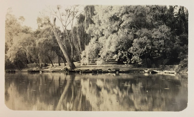
Henry Beater Christian (1886-1962) , was a descendant of one of the earliest settler families in Kew. Employed at the Kew Asylum as a 'public servant', he was a skilled amateur photographer, photographing numerous scenes in Kew and on his travels around Victoria. The majority of his photographs date from 1916 to 1929. His finest photographs are housed in two photograph albums. A fine, early view of Macauley's boat sheds on the Yarra River at Kew.Digital copy of a photograph from page 2 of the 47-page photograph album containing 261 gelatinous silver images, loaned by Diane Washfold with permission given to digitise and hold a copy in our collection. The photograph is of Macauley's boat sheds on the Yarra River at Kew. The boat sheds were located at the west end of Molesworth Street. The photograph is taken from the Yarra Bend Park side of the river, or from a boat on the river. The canoes belonging to Macauley's are lined up on the river bank. "Macauley’s Kew"henry beater christian (1886-1962), landscape photography, kew (vic.) — yarra river, christian-washfold collection, photograph albums, macauley's boat sheds -
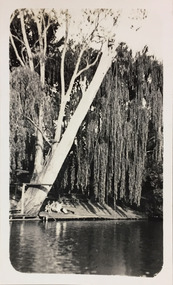 Kew Historical Society Inc
Photograph - Macauley's, Kew, 1924
Henry Beater Christian (1886-1962) , was a descendant of one of the earliest settler families in Kew. Employed at the Kew Asylum as a 'public servant', he was a skilled amateur photographer, photographing numerous scenes in Kew and on his travels around Victoria. The majority of his photographs date from 1916 to 1929. His finest photographs are housed in two photograph albums. A fine, early view of the river bank at Macauley's boat sheds on the Yarra River at Kew.Digital copy of a photograph from page 2 of the 47-page photograph album containing 261 gelatinous silver images, loaned by Diane Washfold with permission given to digitise and hold a copy in our collection. The photograph is of the river bank at Macauley's boat sheds on the Yarra River at Kew. The boat sheds were located at the west end of Molesworth Street. The photograph is taken from the Yarra Bend Park side of the river, or from a boat on the river. A group, probably members of the photographer's family, are sitting underneath a giant weeping willow."Macauley’s Kew"henry beater christian (1886-1962), landscape photography, kew (vic.) — yarra river, christian-washfold collection, photograph albums, macauley's boat sheds -
 Kew Historical Society Inc
Photograph - Macauley's, Kew, 1924
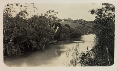
Henry Beater Christian (1886-1962) , was a descendant of one of the earliest settler families in Kew. Employed at the Kew Asylum as a 'public servant', he was a skilled amateur photographer, photographing numerous scenes in Kew and on his travels around Victoria. The majority of his photographs date from 1916 to 1929. His finest photographs are housed in two photograph albums. A fine, early view of Macauley's boat sheds on the Yarra River at Kew. It is also one of the earliest views of Carnsworth, a notable mansion in Studley Park. Digital copy of a photograph from page 2 of the 47-page photograph album containing 261 gelatinous silver images, loaned by Diane Washfold with permission given to digitise and hold a copy in our collection. The photograph is of a stretch of the Yarra River at Kew. In the foreground are the boats of Macauley's Boat Sheds. On the horizon is the red brick tower of J Lewis Carnegie's house 'Carnsworth' in Stawell Street. "Macauley’s Kew"henry beater christian (1886-1962), landscape photography, kew (vic.) — yarra river, christian-washfold collection, photograph albums, macauley's boat sheds, carnsworth -- stawell street -- kew (vic.) -
 Kew Historical Society Inc
Photograph - Yarra River, Kew, 1925
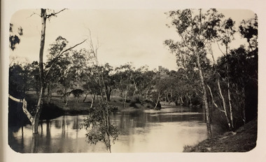
... christian (1886-1962) landscape photography kew (vic.) — yarra river ...Henry Beater Christian (1886-1962) , was a descendant of one of the earliest settler families in Kew. Employed at the Kew Asylum as a 'public servant', he was a skilled amateur photographer, photographing numerous scenes in Kew and on his travels around Victoria. The majority of his photographs date from 1916 to 1929. His finest photographs are housed in two photograph albums. Digital copy of a photograph from page 3 of the 47-page photograph album containing 261 gelatinous silver images, loaned by Diane Washfold with permission given to digitise and hold a copy in our collection. A photograph of a stretch of the Yarra River at Kew. In the distance rises J Lewis Carnegie's mansion 'Carnsworth' in Stawell Street."Yarra Rvr / Kew / 1925"henry beater christian (1886-1962), landscape photography, kew (vic.) — yarra river, christian-washfold collection, photograph albums, carnsworth -
 Kew Historical Society Inc
Photograph - Yarra River, Studley Park, 1924
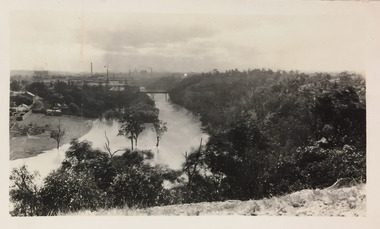
Henry Beater Christian (1886-1962) , was a descendant of one of the earliest settler families in Kew. Employed at the Kew Asylum as a 'public servant', he was a skilled amateur photographer, photographing numerous scenes in Kew and on his travels around Victoria. The majority of his photographs date from 1916 to 1929. His finest photographs are housed in two photograph albums. Digital copy of a photograph from page 7 of the 47-page photograph album containing 261 gelatinous silver images, loaned by Diane Washfold with permission given to digitise and hold a copy in our collection. This photograph was taken during a flood year when the Yarra encroached on the grounds of the Abbotsford Convent. In the distance, the Johnston Street Bridge separates the viewer from the industrialised landscape of Fairfield."Studley Park / Kew"henry beater christian (1886-1962), landscape photography, kew (vic.) — yarra river, christian-washfold collection, photograph albums, fairfield, kew, johnston street bridge, studley park -
 Kew Historical Society Inc
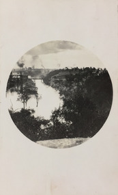
Photograph - Yarra River, Studley Park, 1924
Henry Beater Christian (1886-1962) , was a descendant of one of the earliest settler families in Kew. Employed at the Kew Asylum as a 'public servant', he was a skilled amateur photographer, photographing numerous scenes in Kew and on his travels around Victoria. The majority of his photographs date from 1916 to 1929. His finest photographs are housed in two photograph albums. Digital copy of a photograph from page 7 of the 47-page photograph album containing 261 gelatinous silver images, loaned by Diane Washfold with permission given to digitise and hold a copy in our collection. This photograph was taken during a flood year, perhaps 1923, when the Yarra encroached on the grounds of the Abbotsford Convent. In the distance, the Johnston Street Bridge separates the viewer from the industrialised landscape of Fairfield. In developing the photo, Henry Christian employed a circular frame to artistically focus the view. He empkloyed this technique for what he may have viewed as his best photographs. "Studley Park / Kew"henry beater christian (1886-1962), landscape photography, kew (vic.) — yarra river, christian-washfold collection, photograph albums, fairfield, kew, johnston street bridge, studley park -
 Kew Historical Society Inc
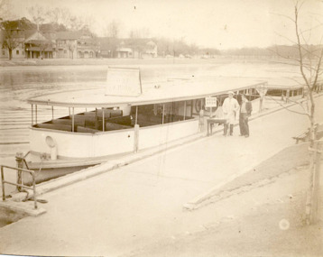
Photograph - Hicks Bros Launch at Princess Walk, circa 1953
Commercially-operated boat tours on the Maribyrnong and Yarra Rivers in Melbourne were a major tourist attraction, especially in the first half of the twentieth century. A number of companies ran ferries and motor-launches to locations such as the Riverview Tea Gardens (1909-1947) at Ascot Vale, and the Hawthorn Tea Gardens on the corner of Power Street and Riversdale Road. One of the families which ran these services was Hicks Bros, which from circa 1921 operated a ferry service from Princess Walk (Melbourne) to Studley Park. This is one of a series of 17 black and white undated photographic proofs donated to the Kew Historical Society in 2013 by the Queenscliffe Historical Museum. The series includes images of individuals, tea rooms, ferries, motor launches, ocean liners and tugs. In 1953, the owner of Hicks Bros was involved in an inquest into the drowning of a Ukrainian tourist on a ferry operated by Melbourne Ferries, a rival firm. In published reports of the inquest, reference is made to a number of photographs taken by Robert Irvine Atchison, part-owner of Hicks Bros. As the reverse of the photographs indicates copyright is held by the State of Victoria, the collection may have derived from that year.Historically significant and rare image of one of the major tour boat services which operated on the Yarra River.Faded black and white photographic proof of a ferry owned by Hicks Bros on the River Yarra at Princess Walk. Two employees stand beside the first of a number of wooden ferries. On the south side of the river, there are the pavilions of a number of boat clubs.ferries, motor launches, yarra river, maribyrnong river, studley park, princess walk, riverview tea gardens, hawthorn tea gardens, tourism - melbourne (vic.), hicks bros, hicks bros launches -
 Kew Historical Society Inc
Photograph - Motor launch at Princess Walk, circa 1953
Commercially-operated boat tours on the Maribyrnong and Yarra Rivers in Melbourne were a major tourist attraction, especially in the first half of the twentieth century. A number of companies ran ferries and motor-launches to locations such as the Riverview Tea Gardens (1909-1947) at Ascot Vale, and the Hawthorn Tea Gardens on the corner of Power Street and Riversdale Road. One of the families which ran these services was Hicks Bros, which from circa 1921 operated a ferry service from Princess Walk (Melbourne) to Studley Park. This is one of a series of 17 black and white undated photographic proofs donated to the Kew Historical Society in 2013 by the Queenscliffe Historical Museum. The series includes images of individuals, tea rooms, ferries, motor launches, ocean liners and tugs. In 1953, the owner of Hicks Bros was involved in an inquest into the drowning of a Ukrainian tourist on a ferry operated by Melbourne Ferries, a rival firm. In published reports of the inquest, reference is made to a number of photographs taken by Robert Irvine Atchison, part-owner of Hicks Bros. As the reverse of the photographs indicates copyright is held by the State of Victoria, the collection may have derived from that year.Historically significant and rare image of one of the major tour boat services which operated on the Yarra River.Faded black and white photographic positive proof of a moto launch (tourist ferry) at Princess Walk. The undated photographic positive was probably taken in the 1950s.tugboats, melbourne, motor launches, ferries, hawthorn tea rooms, hicks bros launches, princess walk, yarra river, tourism, transport -
 Kew Historical Society Inc
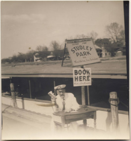
Photograph - Hicks Bros Launch at Princess Walk, circa 1953
Commercially-operated boat tours on the Maribyrnong and Yarra Rivers in Melbourne were a major tourist attraction, especially in the first half of the twentieth century. A number of companies ran ferries and motor-launches to locations such as the Riverview Tea Gardens (1909-1947) at Ascot Vale, and the Hawthorn Tea Gardens on the corner of Power Street and Riversdale Road. One of the families which ran these services was Hicks Bros, which from circa 1921 operated a ferry service from Princess Walk (Melbourne) to Studley Park. This is one of a series of 17 black and white undated photographic proofs donated to the Kew Historical Society in 2013 by the Queenscliffe Historical Museum. The series includes images of individuals, tea rooms, ferries, motor launches, ocean liners and tugs. In 1953, the owner of Hicks Bros was involved in an inquest into the drowning of a Ukrainian tourist on a ferry operated by Melbourne Ferries, a rival firm. In published reports of the inquest, reference is made to a number of photographs taken by Robert Irvine Atchison, part-owner of Hicks Bros. As the reverse of the photographs indicates copyright is held by the State of Victoria, the collection may have derived from that year.Historically significant and rare image of one of the major tour boat services which operated on the Yarra River.Faded black and white photographic proof of a ferry owned by Hicks Bros on the River Yarra at Princess Walk. The ferry has signage confirming the company (Hicks Bros Launches) and the destinations (Studley Park, Hawthorn Tea Rooms). A man, probably Robert Atchison, co-owner of the ferry service, in a captain's hat is selling tickets. Above the roof line of the ferry can be seen the boat houses on the opposite bank. ferries, motor launches, yarra river, maribyrnong river, studley park, princess walk, riverview tea gardens, hawthorn tea gardens, tourism - melbourne (vic.), hicks bros, hicks bros launches -
 Kew Historical Society Inc
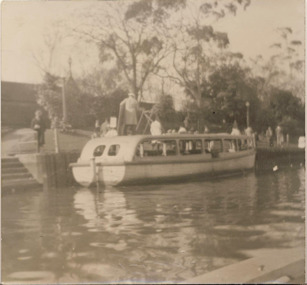
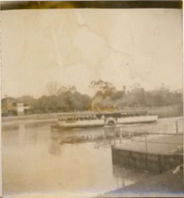
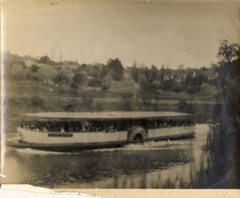
Photograph - Ferry on the Yarra River, circa 1953
Commercially-operated boat tours on the Maribyrnong and Yarra Rivers in Melbourne were a major tourist attraction, especially in the first half of the twentieth century. A number of companies ran ferries and motor-launches to locations such as the Riverview Tea Gardens (1909-1947) at Ascot Vale, and the Hawthorn Tea Gardens on the corner of Power Street and Riversdale Road. One of the families which ran these services was Hicks Bros, which from circa 1921 operated a ferry service from Princess Walk (Melbourne) to Studley Park. This is one of a series of 17 black and white undated photographic proofs donated to the Kew Historical Society in 2013 by the Queenscliffe Historical Museum. The series includes images of individuals, tea rooms, ferries, motor launches, ocean liners and tugs. In 1953, the owner of Hicks Bros was involved in an inquest into the drowning of a Ukrainian tourist on a ferry operated by Melbourne Ferries, a rival firm. In published reports of the inquest, reference is made to a number of photographs taken by Robert Irvine Atchison, part-owner of Hicks Bros. As the reverse of the photographs indicates copyright is held by the State of Victoria, the collection may have derived from that year.Historically significant and rare image of one of the major tour boat services which operated on the Yarra River.Faded black and white photographic proof of a ferry, possibly one of a number owned by Hicks Bros on the River Yarra. The single storey wooden ferry has a wheel that is motor driven. The popularity of ferry services is indicated by the number of passengers on board.ferries, motor launches, yarra river, studley park, princess walk, hawthorn tea gardens, tourism - melbourne (vic.), hicks bros, hicks bros launches -
 Kew Historical Society Inc
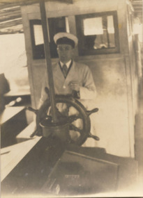
Photograph - Hicks Bros Motor Launch, circa 1953
Commercially-operated boat tours on the Maribyrnong and Yarra Rivers in Melbourne were a major tourist attraction, especially in the first half of the twentieth century. A number of companies ran ferries and motor-launches to locations such as the Riverview Tea Gardens (1909-1947) at Ascot Vale, and the Hawthorn Tea Gardens on the corner of Power Street and Riversdale Road. One of the families which ran these services was Hicks Bros, which from circa 1921 operated a ferry service from Princess Walk (Melbourne) to Studley Park. This is one of a series of 17 black and white undated photographic proofs donated to the Kew Historical Society in 2013 by the Queenscliffe Historical Museum. The series includes images of individuals, tea rooms, ferries, motor launches, ocean liners and tugs. In 1953, the owner of Hicks Bros was involved in an inquest into the drowning of a Ukrainian tourist on a ferry operated by Melbourne Ferries, a rival firm. In published reports of the inquest, reference is made to a number of photographs taken by Robert Irvine Atchison, part-owner of Hicks Bros. As the reverse of the photographs indicates copyright is held by the State of Victoria, the collection may have derived from that year.Historically significant and rare image of one of the major tour boat services which operated on the Yarra River.Faded black and white photographic proof of worker of a ferry service, steering a ferry on the Yarra River. He wears a captain's peaked hat and a coat.ferries, motor launches, yarra river, studley park, princess walk, hawthorn tea gardens, tourism - melbourne (vic.), hicks bros, hicks bros launches -
 Kew Historical Society Inc
Photograph - Morell Bridge, Yarra River, circa 1953
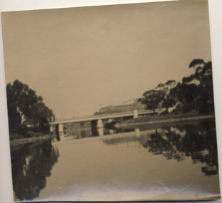
This is one of a series of 17 black and white undated photographic proofs donated to the Kew Historical Society in 2013 by the Queenscliffe Historical Museum. The series includes images of individuals, tea rooms, ferries, motor launches, ocean liners and tugs. Faded black and white photographic positive proof of the Morell Bridge (formerly the Anderson Street Bridge) across the Yarra River near the Botanical Gardens. Princess Bridge can be seen through the arches of the Morell Bridge. The undated photographic positive was probably taken in the 1950s.melbourne, transport, bridges -- yarra river, morell bridge, anderson street bridge, yarra river -
 Kew Historical Society Inc
Photograph - Ferry on the Yarra River, circa 1953
Commercially-operated boat tours on the Maribyrnong and Yarra Rivers in Melbourne were a major tourist attraction, especially in the first half of the twentieth century. A number of companies ran ferries and motor-launches to locations such as the Riverview Tea Gardens (1909-1947) at Ascot Vale, and the Hawthorn Tea Gardens on the corner of Power Street and Riversdale Road. One of the families which ran these services was Hicks Bros, which from circa 1921 operated a ferry service from Princess Walk (Melbourne) to Studley Park. This is one of a series of 17 black and white undated photographic proofs donated to the Kew Historical Society in 2013 by the Queenscliffe Historical Museum. The series includes images of individuals, tea rooms, ferries, motor launches, ocean liners and tugs. In 1953, the owner of Hicks Bros was involved in an inquest into the drowning of a Ukrainian tourist on a ferry operated by Melbourne Ferries, a rival firm. In published reports of the inquest, reference is made to a number of photographs taken by Robert Irvine Atchison, part-owner of Hicks Bros. As the reverse of the photographs indicates copyright is held by the State of Victoria, the collection may have derived from that year.Historically significant and rare image of one of the major tour boat services which operated on the Yarra River.Faded black and white photographic proof of a ferry, possibly one of a number owned by Hicks Bros on the River Yarra. The single storey wooden ferry has a wheel that is motor driven. The popularity of ferry services is indicated by the number of passengers on board.ferries, motor launches, yarra river, studley park, princess walk, hawthorn tea gardens, tourism - melbourne (vic.), hicks bros, hicks bros launches -
 Kew Historical Society Inc
Journal, Kew Historical Society, Newsletter No.138, March 2022
Exhibitions and grants / Robert Baker p1. Office Bearers / p2. History News: acquisitions; Victorian Collections; grants & sponsors; 2022 McIntyre Lecture / p3. Madford: a former mansion in Wellington Street / Robert Baker p4. Life on the River: Macauley's Boathouse / Julie King p5. What's A Quoll? - lively and appealing squirrel-like spotted cats / Suzanne McWha p7. In March 1922 / Trove p8. A Coronation Dress: from Westminster Abbey to Kew / Suzanne McWha & Felicity Renowden p9. The Yarra Yarra Jazz Band / Brad Miles p11. Membership & Donations p12.Published quarterly since 1977, the newsletters of the Kew Historical Society contain significant research by members exploring relevant aspects of the Victorian and Australian Framework of Historical Themes. Frequently, articles on people, places and artefacts are the only source of information about an aspect of Kew, and Melbourne’s history.non-fictionExhibitions and grants / Robert Baker p1. Office Bearers / p2. History News: acquisitions; Victorian Collections; grants & sponsors; 2022 McIntyre Lecture / p3. Madford: a former mansion in Wellington Street / Robert Baker p4. Life on the River: Macauley's Boathouse / Julie King p5. What's A Quoll? - lively and appealing squirrel-like spotted cats / Suzanne McWha p7. In March 1922 / Trove p8. A Coronation Dress: from Westminster Abbey to Kew / Suzanne McWha & Felicity Renowden p9. The Yarra Yarra Jazz Band / Brad Miles p11. Membership & Donations p12.kew historical society (vic.) -- periodicals., kew historical society (vic.) -- newsletters, kew historical society (vic.) -- journals -
 Kew Historical Society Inc
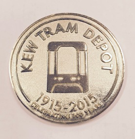
Souvenir - Medallion, Kew Tram Depot 1915-2015, 2015
Kew tram depot is located on the corner of Barkers Road and High Street, Kew, a suburb of Melbourne, Australia. Operated by Yarra Trams, it is one of eight tram depots on the Melbourne tram network. The depot opened on 8 May 1915.Commemorative medallion in blue presentation box, given to the Kew Historical Society on the anniversary of the Kew Depot in 2015.Front: Schematic engraving of tram with the words "Kew Tram Depot : 1915-2015 : Celebrating 100 Years". Reverse: Schematic engraving of exterior of Depot, surrounded by the words "Commemorating all staff who have contributed to the success of Kew Depot".kew tram depot, commemorative medallions, tramways memorabilia -
 Kew Historical Society Inc
Photograph, 'Yarra Bluff', Redmond Street, c.1965
This work forms part of the collection assembled by the historian Dorothy Rogers, that was donated to the Kew Historical Society by her son John Rogers in 2015. The manuscripts, photographs, maps, and documents were sourced by her from both family and local collections or produced as references for her print publications. Many were directly used by Rogers in writing ‘Lovely Old Homes of Kew’ (1961) and 'A History of Kew' (1973), or the numerous articles on local history that she produced for suburban newspapers. Most of the photographs in the collection include detailed annotations in her hand. The Rogers Collection provides a comprehensive insight into the working habits of a historian in the 1960s and 1970s. Together it forms the largest privately-donated collection within the archives of the Kew Historical Society.'Yarra Bluffs' was the home of George Henry (1831-1906) and Allegra Charnock Mott (1831-1905), newspaper proprietor (and also a friend of John Inglis, father of Kew doctor, Edgar Inglis, who bought land adjacent to this property in the 1890s). Walter was a son who drowned in the Yarra in a swimming accident January 2, 1890. George & Allegra had fourteen children and the family continued newspaper publishing interests from 1853 until 1986, over four generations.' (Andrew Mott, 2015)[Annotation on reverse by Dorothy Rogers] "Walter Mott's house - formerly Yarra Bluff, Redmond St Kew. This was formerly the back entrance. It is now 2 flats. The upper is occupied by the present owner Mr. Tyler. Walter was drowned in the Yarra. He built the house about ____. He commenced the Kew Mercury in 188_. Back view of George Motts home (1890) Redmond Street".walter mott, yarra bluff, studley park, dorothy rogers -
 Kew Historical Society Inc
Photograph, J E & B L Rogers, 'Ivy Grange', Malmsbury Street, c. 1965
Rate Book evidence records that by 1870 Charles Vickers, architect, was the occupier of this house, having an NA.V. at that date o f£1105, although it is apparent that the house was in fact built by 1864, from the dat; set in the brickwork above the main door. In 1873 the property was purchased by David Beath, a merchant, and it was in the following year that the house was first recorded as 'Ivy Grange'. Beath was a deeply religious man and was a foundation member of both the Congregational and the Presbyterian (the Church of Scotland) Churches of Kew . He added, probably the tower wing, to the house in 1877 when architects Crouch and Wilson called tenders in that year 'for the erection of bluestone additions to (a) villa at Kew, for Davis Beath Esq.' The house was again added to in 1885 by the leading firm Reed, Henderson and Smart. For a number of years in the 1920s 'Ivy Grange' was used as a private mental hospital and is currently a guest house. In 1921 a fete was held at Ivy Grange in aid of building a new church (Sacred Heart, Kew): "Garden Fete in Aid of New Church, Kew. A SUCCESSFUL FUNCTION. Beautiful weather favoured the opening of a garden fete at "Ivy Grange," the residence of Mr. and Mrs. J. Lawlor, Malmsbury and Princess streets, Kew, on last Saturday afternoon, in aid of the fine new Church of the Sacred Heart, Kew, which is now receiving its finishing touches. Not content to wait for the official opening, the lady stallholders did a good business on the previous evening. The ceremony was performed" by the Very Rev. Dean Hegarty, P.P., V.F. (Carlton), with whom were associated the Rev. J. Manly, P.P. (Kew), and the Rev. R. S. Benson, P.P. (South Yarra), Mr. and Mrs. J. Lawlor, and others. Fr. Manly, who was cordially received, said he desired to thank Mr. and Mrs. Lawlor for lending their charming grounds, and for the trouble, time and expense they had given to preparing for the fete. He wished to thank Dean Hegarty for coming to open the fete. The Dean had been a dear and lifelong friend of the late Fr. O'Donoghoe, the beloved pastor of the Kew parish. Next June the Dean would celebrate the golden jubilee of his priesthood, so they could see that he was not a young man. (Laughter.) He hoped that the fete would be a great success, and that when his Grace the Archbishop —: (applause) — should open the new church, he (the speaker) would be able to present a satisfactory financial statement. (Applause.) Dean Hegarty, who was very cordially received, said it was a source of great pleasure to him to come to Kew, of which he entertained many pleasant recollections. The new church would have delighted the heart of their late beloved pastor, but it had pleased God to take him to a holler temple. His mantle had fallen on worthy shoulders, in the person of Fr. Manly—(applause)—who was carrying on the work of the parish well and vigorously. (Applause.) Some wondered how these great works were successfully accomplished. The prime factor in the wonderful progress of the Church— the work of the people, priests and nuns—was their deep, abiding Catholic faith. (Applause.) Kew was not by any means a large parish, yet look at the magnificent church that Fr. Manly was building on the hill! He said to his people, "Come, follow me, and we shall win through." (Applause.) It gave him great pleasure to declare the fete open, and he wished it the highest measure of success. (Prolonged applause.) Mr. J. Lawlor, who was greeted with applause, in moving a hearty vote of thanks to Dean Hegarty for his presence and support, said he knew of the great work done by the Dean in Gippsland, where he (the speaker) lived when a young man. The Dean ministered to a parish at that time as large as was the diocese of Sale to-day. The Dean and Fr. Manly reflected credit on the pioneer priests, who had laid well and solidly the foundations, of religion in Victoria. (Applause.) He was glad that reference had been~made to the work of their late beloved pastor, Fr. O'Donoghoe. : Mr. Pierce Cody seconded the motion, which, was carried by acclamation. The Dean,* in acknowledging the compliment, paid a tribute to Mr. and Mrs. Lawlor for their great generosity in connection with the fete, and complimented them on their successful efforts. (Applause.). A cafe chantant, organised by Mr. John. Sullivan, was contributed to by Misses G. Hornal, M. O'Donnell, Ella Burke, Eileen Burke, Alice Marsh, and M. Carrucan, and Messrs. T. Hammond, J. Donovan, J. Sullivan, and Fr. Lanigan. Mrs. J. Donovan was at the piano. St. Vincent de Paul Boys' Orphanage Band (South Melbourne) rendered selections. The stalls ware as follow:—Cake and Sweets Stall: Mesdames Needham, Treacey, Lynch and Cody. Fancy Stall: Mesdames Lawlor, J. P. Martin, M. Treacey, Simpson, Giddons and A. Molton, and Miss, Shirley. Refrestiment Stall: Mesdames Shiels, Hunter, Kealy, Duane and the Misses Turner and Delahunty; Produce Stall: Mesdames O'Sullivan, Mareli, Carrucan, and Kennedy. Mr. P. J. Kennedy acted as hon. general secretary. The fete was continued in the evening, the grounds being brilliantly illuminated. (Advocate (Melbourne, Vic. : 1868 - 1954), Thursday 7 April 1921, page 13) In 1930 it was acquired by the Carmelite Fathers for use as a novitiate: "IVY GRANGE," KEW." Acquired for Carmelite Novitiate. The valuable property, "Ivy Grange," Kew. which" belonged to the McGuiness family has been acquired by the Carmelite Fathers for a novitiate." (Advocate (Melbourne, Vic. : 1868 - 1954), Thursday 18 September 1930, page 18This work forms part of the collection assembled by the historian Dorothy Rogers, that was donated to the Kew Historical Society by her son John Rogers in 2015. The manuscripts, photographs, maps, and documents were sourced by her from both family and local collections or produced as references for her print publications. Many were directly used by Rogers in writing ‘Lovely Old Homes of Kew’ (1961) and 'A History of Kew' (1973), or the numerous articles on local history that she produced for suburban newspapers. Most of the photographs in the collection include detailed annotations in her hand. The Rogers Collection provides a comprehensive insight into the working habits of a historian in the 1960s and 1970s. Together it forms the largest privately-donated collection within the archives of the Kew Historical Society.Ivy Grange, cnr Malmsbury and Princess Streets, Kew. Ivy Grange. Home of David Beath. Commenced 1864, Tower Wing added 1877. Chap 38.ivy grange, malmsbury street, dorothy rogers, david beath, charles vickers, crouch and wilson, kew houses -
 Kew Historical Society Inc
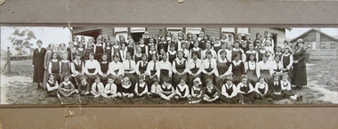
Photograph - Woodbury Ladies’ College, 1919
Woodbury College is an indirect predecessor of Preshil School in Kew. Woodbury College was founded in Glenferrie Road by a Miss Harcourt, former principal of Sydenham College, Moonee Ponds. Miss Harcourt maintained the school until the goodwill was purchased in 1908 by Miss LJ Macey, who had previously operated Lillsden Ladies' College in Edgevale Road, between c.1891 and c.1903. The first school was in a rented building on the south side of Cotham Road between Atkins and Davis Streets. In 1910, a new school building was built on the corner of Uvadale Grove and Cotham Road [the building is still extant as of 2020]. Woodbury College was operated by Miss LJ and Miss HJ Macey until 1920. In 1921, the school amalgamated with the newly formed St Andrew's College, Mont Victor Road, Kew (Vic) under the leadership of Rev JT Lawton [who had previously been principal of St Andrew's School of the 'Pathfinder' in South Yarra]. Miss Macey was for a period the Headmistress of the amalgamated school. Another teacher at the school was Miss Margaret JR Lyttle, who in 1931, left St Andrew's to form the Preshil School.A rare panoramic photograph of Woodbury College in Kew, Victoria. The photograph is part of a large collection of original manuscripts and ephemera relating to the school.Panoramic photograph of the students and teachers of Woodbury College, Cotham Road (Kew). Students identified in the photograph include: Back Row, 5th from left Betty Paton; 4th from right - Jean Strickey (sic).Annotation to reverse: "Woodbury College (Miss L.J. Massey) established Cotham Rd Kew. Est. at this venue 1908. Later joined by Rev. J.T. Lawton & formed a school in Mount Victor Rd Kew St Andrew’s College in 1921.’ woodbury college, cotham road (kew), education, schools, kew, l.j. massey, j.t. lawton, st andrew's college -
![Studley Park [Toll] Bridge, Kew](/media/collectors/550653872162f11fb04854aa/items/579ebf04d0cdd117c4c0815f/item-media/579ebf3ad0cdd117c4c0953e/item-fit-380x285.jpg) Kew Historical Society Inc
Kew Historical Society IncPhotograph, Studley Park [Toll] Bridge, Kew, 1870s
‘Studley Park Bridge’ or ‘penny bridge’ linked Church Street in Abbotsford and what is now Yarra Bend Park. The privately constructed bridge opened in 1857, gaining its popular name from the toll charged at the Abbotsford end. The engineer of the 485ft wide bridge was Mr. Austin and the builder was ‘Mr Grant, who threw the bridge over the Niagara’. Following the opening of Johnston Street Bridge, declining tolls led to the Bridge falling into disrepair. Badly damaged by the flood of 1891, the Bridge was compulsorily acquired by the Government in 1899, and later dismantled and sold for firewood.This work forms part of the collection assembled by the historian Dorothy Rogers, that was donated to the Kew Historical Society by her son John Rogers in 2015. The manuscripts, photographs, maps, and documents were sourced by her from both family and local collections or produced as references for her print publications. Many were directly used by Rogers in writing ‘Lovely Old Homes of Kew’ (1961) and 'A History of Kew' (1973), or the numerous articles on local history that she produced for suburban newspapers. Most of the photographs in the collection include detailed annotations in her hand. The Rogers Collection provides a comprehensive insight into the working habits of a historian in the 1960s and 1970s. Together it forms the largest privately-donated collection within the archives of the Kew Historical Society.A print, taken in the 1960s by Dorothy Rogers, from an original albumen silver photograph now in the collection of the Kew Historical Society. The photograph shows the toll bridge (also known as the Penny Bridge) from the northern end."P[enny] Toll Bridge - built 1857. from old photo"studley park bridge, penny bridge, bridge, timber bridge, toll bridge -
 Kew Historical Society Inc
Plan, Studley Park Estate, 1910
Prue Sanderson, in her groundbreaking ‘City of Kew Urban Conservation Study : Volume 2 - Development History’ (1988), summarised the periods of urban development and subdivisions of land in Kew. The periods that she identified included 1845-1880, 1880-1893, 1893-1921, 1921-1933, 1933-1943, and Post-War Development. These periods were selected as they represented periods of rapid growth or decline in urban development. An obvious starting point for Sanderson’s groupings involved population growth and the associated economic cycles. These cycles also highlighted urban expansion onto land that was predominantly rural, although in other cases it represented the decline and breakup of large estates. A number of the plans in the Kew Historical Society’s collection can also be found in other collections, such as those of the State Library of Victoria and the Boroondara Library Service. A number are however unique to the collection.The Kew Historical Society collection includes almost 100 subdivision plans pertaining to suburbs of the City of Melbourne. Most of these are of Kew, Kew East or Studley Park, although a smaller number are plans of Camberwell, Deepdene, Balwyn and Hawthorn. It is believed that the majority of the plans were gifted to the Society by persons connected with the real estate firm - J. R. Mathers and McMillan, 136 Cotham Road, Kew. The Plans in the collection are rarely in pristine form, being working plans on which the agent would write notes and record lots sold and the prices of these. The subdivision plans are historically significant examples of the growth of urban Melbourne from the beginning of the 20th Century up until the 1980s. A number of the plans are double-sided and often include a photograph on the reverse. A number of the latter are by noted photographers such as J.E. Barnes.Coloured lithograph of a subdivision plan of the Studley Park Estate, bordered by Yarra, Willsmere Road and the Outer Circle Railway line. The estate was listed in 1910 and was the subject of a planning dispute between the developer and the Town of Kew in relation to flood levels and the suitability of the land for housing. In many cases the names of streets were subsequently changed. The layout was also affected by the creation of the Eastern Freeway. A newspaper report of the day described the subdivision as a: "GOLDEN OPPORTUNITY. We are pleased to submit for PRIVATE SALE that magnificent ESTATE, situated only 4 1/2 miles from the Melbourne General Post Office, STUDLEY PARK ESTATE. KF/NV. Doubtless the CHEAPEST LAND EVER OFFERED having extensive frontages to the prettiest spot on the River Yarra and the National Park, commanding lovely river and landscape views, and acknowledged to be the finest land available so close to the city. The PRICES ARE EXTREMELY MODERATE; The TERMS ARE SIMPLY MARVELLOUS. NO DEPOSIT. NO DEPOSIT. NO DEPOSIT. Allotments and prices to suit everyone."subdivision plans - kew, studley park estate -
 Kew Historical Society Inc
Plan - Subdivision Plan, Goldthorns House Estate, 1940
Pru Sanderson, in her groundbreaking ‘City of Kew Urban Conservation Study : Volume 2 - Development History’ (1988), summarised the periods of urban development and subdivisions of land in Kew. The periods that she identified included 1845-1880, 1880-1893, 1893-1921, 1921-1933, 1933-1943, and Post-War Development. These periods were selected as they represented periods of rapid growth or decline in urban development. An obvious starting point for Sanderson’s groupings involved population growth and the associated economic cycles. These cycles also highlighted urban expansion onto land that was predominantly rural, although in other cases it represented the decline and breakup of large estates. A number of the plans in the Kew Historical Society’s collection can also be found in other collections, such as those of the State Library of Victoria and the Boroondara Library Service. A number are however unique to the collection.The Kew Historical Society collection includes almost 100 subdivision plans pertaining to suburbs of the City of Melbourne. Most of these are of Kew, Kew East or Studley Park, although a smaller number are plans of Camberwell, Deepdene, Balwyn and Hawthorn. It is believed that the majority of the plans were gifted to the Society by persons connected with the real estate firm - J. R. Mathers and McMillan, 136 Cotham Road, Kew. The Plans in the collection are rarely in pristine form, being working plans on which the agent would write notes and record lots sold and the prices of these. The subdivision plans are historically significant examples of the growth of urban Melbourne from the beginning of the 20th Century up until the 1980s. A number of the plans are double-sided and often include a photograph on the reverse. A number of the latter are by noted photographers such as J.E. Barnes.The first subdivision of Goldthorns created the Goldthorns Hill Estate. Following that subdivision, seven additional lots were offered between Normanby Road, Argyle Road and Lady Loch’s Drive on the proviso that the estate, including Goldthorns was not sold as a single lot. The subdivision plan advises that the lots are situated in one of the most charming and popular residential areas in Kew and is surrounded by modern homes. Typically, the subdivision plan proposes the advantage of its proximity to Cotham Road and the tram to Collins Street. Because of the elevation of Goldthorns, much is made of the ‘bright, sunny and extensive outlook to the Northern Ranges’ and that it overlooks the Yarra Valley. One of the more interesting aspects of the plan is that it shows the outline of Goldthorns in the mid to late 1920s. Its profile today remains virtually the same."Goldthorns" House Estate at topsubdivision plans - kew, goldthorns house estate -
 Kew Historical Society Inc
Plan - Subdivision Plan, Oswinia Estate, East Kew, c.1925
Prue Sanderson, in her groundbreaking ‘City of Kew Urban Conservation Study : Volume 2 - Development History’ (1988), summarised the periods of urban development and subdivisions of land in Kew. The periods that she identified included 1845-1880, 1880-1893, 1893-1921, 1921-1933, 1933-1943, and Post-War Development. These periods were selected as they represented periods of rapid growth or decline in urban development. An obvious starting point for Sanderson’s groupings involved population growth and the associated economic cycles. These cycles also highlighted urban expansion onto land that was predominantly rural, although in other cases it represented the decline and breakup of large estates. A number of the plans in the Kew Historical Society’s collection can also be found in other collections, such as those of the State Library of Victoria and the Boroondara Library Service. A number are however unique to the collection.Subdivision plans are historically important documents used as evidence of the growth of suburbs in Australia. They frequently provide information about when the land was sold on which a built structure was subsequently constructed as well as evidence relating to surveyors and real estate and financial agents. The numerous subdivision plans in the Kew Historical Society's collection represent working documents, ranging from the initial sketches made in planning a subdivision to printed plans on which auctioneers or agents listed the prices for which individual lots were sold. In a number of cases, the reverse of a subdivision plan in the collection includes a photograph of a house that was also for sale by the agent. These photographs provide significant heritage information relating house design and decoration, fencing and household gardens.The ‘Oswinia Estate’ subdivision in East Kew was planned and auctioned in the first half of the 1920s. 169 allotments were created in the triangular section of land bordered by High Street, Burke Road and the Government Boulevard (later Kilby Road). The only piece of land excluded was that where the previous Kew Pound had been located at the east tip of the triangle. Allotments were created fronting Glass, High, Namur, Oswin Streets, Irymple Avenue, and the Government Boulevard. The name for the Estate was derived from Oswin’s farm, which had been one of the largest landholdings in East Kew. The selling agents annotated the plan in our collection with crosses indicating those lots that had been sold. The inset locality plan is particularly interesting as it shows the route and stations of the Outer Circle Railway. When the subdivision plan was created, it included the proposed bridge over the Yarra at Burke Road. The bridge was to be officially opened in 1926.subdivision plans - east kew, oswinia estate, high street, glass street, namur street, government boulevard - kilby road, irymple street, oswin street -
 Kew Historical Society Inc
Plan - Subdivision Plan, Boulevard Estate - Boulevard Section, 1930-1936
Pru Sanderson, in her groundbreaking ‘City of Kew Urban Conservation Study : Volume 2 - Development History’ (1988), summarised the periods of urban development and subdivisions of land in Kew. The periods that she identified included 1845-1880, 1880-1893, 1893-1921, 1921-1933, 1933-1943, and Post-War Development. These periods were selected as they represented periods of rapid growth or decline in urban development. An obvious starting point for Sanderson’s groupings involved population growth and the associated economic cycles. These cycles also highlighted urban expansion onto land that was predominantly rural, although in other cases it represented the decline and breakup of large estates. A number of the plans in the Kew Historical Society’s collection can also be found in other collections, such as those of the State Library of Victoria and the Boroondara Library Service. A number are however unique to the collection.The Kew Historical Society collection includes almost 100 subdivision plans pertaining to suburbs of the City of Melbourne. Most of these are of Kew, Kew East or Studley Park, although a smaller number are plans of Camberwell, Deepdene, Balwyn and Hawthorn. It is believed that the majority of the plans were gifted to the Society by persons connected with the real estate firm - J. R. Mathers and McMillan, 136 Cotham Road, Kew. The Plans in the collection are rarely in pristine form, being working plans on which the agent would write notes and record lots sold and the prices of these. The subdivision plans are historically significant examples of the growth of urban Melbourne from the beginning of the 20th Century up until the 1980s. A number of the plans are double-sided and often include a photograph on the reverse. This plan shows a subdivision with two sections: the ‘Boulevard Section’ and the ‘Riverside Section’. The first of these sections bordered Burke Road between Kilby Road and the farm beside the Yarra. Kilby Road, Munro Road, Burke Road and Old Burke Road bordered the 102 lots in the Boulevard Section of the plan. The streets within the Section included Walbundry Avenue, Inverness Way, Riverside Avenue, Cascade Street and Kyora Parade. These street names, at least in this subdivision plan linked the two Sections of the subdivision. At a later date, the City of Kew decided to alter the street names. Walbundry, Inverness, Riverside, Cascade and Kyora were all renamed as ‘Drives’ (e.g. Kyora Drive). The subdivision plan is of interest in that it names High Street in Kew as Doncaster Road. It also shows the location of the wooden church that was later removed to Yarraville on the corner of Kilby Road and High Street. The plan predates later developments such as the S. E. Dickens Supermarket.subdivision plans - east kew, boulevard estate, munro road -- kew east (vic.), kilby road -- kew east (vic.), burke road -- kew east (vic.), walbundry avenue -- kew east (vic.), inverness way -- kew east (vic.), riverside avenue -- kew east (vic.), cascade drive -- kew east (vic.), nyora parade -- kew east (vic.) -
 Kew Historical Society Inc
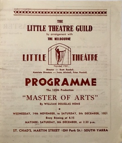
Programme - Theatre Programme, Master of Arts / by William Douglas Home, 1951
Arthur Henry Dear was an employee of the City of Kew, acting as Hall Keeper of the Kew Recreation Hall in Wellington Street, and later the new Kew City Hall in Cotham Road. The Arthur Dear Collection contains memorabilia - tickets, programmes, invitations - as well as his identification badge. Items in the collection dates from the 1940s to the 1960s. The Kew Recreation Hall (Wellington Street) and later the Kew City Hall (Cotham Road) were major locations in suburban Melbourne in the postwar period for civic and private events including theatre productions and exhibitions. The Arthur Dear Collection (in conjunction with the scrapbooks compiled by Marion Tilley) provide a comprehensive snapshot of performing arts in Kew during the 1940s, 1950s and 1960s. The collection includes valuable data about performances, performers, directors etc., during this period. Programme produced by The Little Theatre Guild for Master of Arts by William Douglas Home. The production was held at St. Chads, Martin Street, South Yarra in November and December 1951.The programme includes a cast list. 4 pp.arthur dear collection, the little theatre company, performing arts -- kew -- victoria, kew recreation hall -- wellington street, city of kew, theatre memorabilia -
 Kew Historical Society Inc
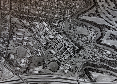
Photograph - Aerial Photograph, Aerial Photograph of Willsmere, circa 1980, c. 1980
This aerial photograph shows the Kew Cottages, and doctors/clergy residences on the north side of Wills Street, before the State Government sold the land for residential development. The doctors residences in Wills street were made of 'Glen Iris' Olympic Bricks. According to neighbours of the time most of the buildings were demolished overnight in the 1980s.Aerial photograph of Willsmere and the Kew Cottages bounded by the Boulevard, the Chandler Highway, Princess Street and Fellows Street. The roundabout at the intersection of Princess Street, Wills Street, and Eglinton Street is at the top left. The Eastern Freeway is at the lower edge of the photograph.kew cottages, eastern freeway, willsmere, yarra river, aerial photographs -- kew (vic), kew boulevard, willsmere mental hospital, kew mental hospital, kew childrens cottages -
 Kew Historical Society Inc
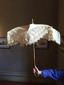
Accessory - Cream Silk & Lace Parasol, c.1900
Joseph Butterworth COOMBS (1842-1901), was an accountant who founded a successful mercantile trading company. At the time of his marriage to Caroline Mary MICHEL in 1869, Coombs had already purchased ten acres of Studley Park. The acreage included land on the west of Fenwick Street that extended along lower Stawell Street to the corner of Yarra Street, all of it connected directly to the Yarra environs. A right of way to Studley Park Road was on the title, though Coombs went on to purchase more land, some of which faced Studley Park Road. In addition to owning the Studley Park acreage, Coombs later acquired 1,201 acres of land abutting the Acheron River. While retaining the Kew property he became a Taggerty Councillor and was Shire President for a time. J.B. Coombs died at Acheron Station in 1901 (aged 59 years). A few months after, tenders were called to repair the Kew dwelling, the Fenwick Street property now appearing in records with the name ‘Hope Mansell’. Caroline Coombs remained at Hope Mansell until she died in 1924, survived by three sons and five daughters. Not long after her death, advertisements appeared for the sale of the Studley Park land. The sale seems to have been a mechanism for distribution of the Estate, as the following year the original ten acre holding was transferred to members of the family. The eldest daughter Mabel married William Younger who, with his brother Alexander, developed Younger and Mackie Courts, both south of Studley Park Road. [Research: Kerry Fairbank]In 1961, the granddaughter of Joseph and Caroline Coombs, Mabel Isola (Younger) Grattan, donated ten 19th century dresses and parasols to the Kew Historical Society. The costumes, now known as the 'Coombs Collection', are the earliest recorded items of clothing to enter the Society's collection. Each of the items in the Coombs Collection, of which this item forms a part, is historically, aesthetically and socially significant. As a collection, the costumes includes outstanding examples of morning wear, day dresses, wedding dresses, and clothing accessories, providing evidence of outstanding dressmaker skills in Victoria during the mid to late Victorian period. One of a pair of cream silk parasols, each bordered by overlapping bands of beige lace. The underlying structure and mechanism includes a bent cane handle and black metal expanding spokes. The lace borders are layered to create an overlapping fringe. The high-domed umbrellas may have been created for a bridal party."Coombs Collection"coombs collection, clothing accessories, parasols -
 Kew Historical Society Inc
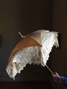
Accessory - Cream Silk & Lace Parasol, c. 1900
Joseph Butterworth COOMBS (1842-1901), was an accountant who founded a successful mercantile trading company. At the time of his marriage to Caroline Mary MICHEL in 1869, Coombs had already purchased ten acres of Studley Park. The acreage included land on the west of Fenwick Street that extended along lower Stawell Street to the corner of Yarra Street, all of it connected directly to the Yarra environs. A right of way to Studley Park Road was on the title, though Coombs went on to purchase more land, some of which faced Studley Park Road. In addition to owning the Studley Park acreage, Coombs later acquired 1,201 acres of land abutting the Acheron River. While retaining the Kew property he became a Taggerty Councillor and was Shire President for a time. J.B. Coombs died at Acheron Station in 1901 (aged 59 years). A few months after, tenders were called to repair the Kew dwelling, the Fenwick Street property now appearing in records with the name ‘Hope Mansell’. Caroline Coombs remained at Hope Mansell until she died in 1924, survived by three sons and five daughters. Not long after her death, advertisements appeared for the sale of the Studley Park land. The sale seems to have been a mechanism for distribution of the Estate, as the following year the original ten acre holding was transferred to members of the family. The eldest daughter Mabel married William Younger who, with his brother Alexander, developed Younger and Mackie Courts, both south of Studley Park Road. [Research: Kerry Fairbank]In 1961, the granddaughter of Joseph and Caroline Coombs, Mabel Isola (Younger) Grattan, donated ten 19th century dresses and parasols to the Kew Historical Society. The costumes, now known as the 'Coombs Collection', are the earliest recorded items of clothing to enter the Society's collection. Each of the items in the Coombs Collection, of which this item forms a part, is historically, aesthetically and socially significant. As a collection, the costumes includes outstanding examples of morning wear, day dresses, wedding dresses, and clothing accessories, providing evidence of outstanding dressmaker skills in Victoria during the mid to late Victorian period. One of a pair of cream silk parasols, each bordered by overlapping bands of beige lace. The underlying structure and mechanism includes a bent cane handle and black metal expanding spokes. The lace borders are layered to create an overlapping fringe. The high-domed umbrellas may have been created for a bridal party. This umbrella cannot be opened due to the silk being shattered."Coombs Collection"coombs collection, clothing accessories, parasols