Showing 110530 items
matching roads
-
 Pyrenees Shire Council
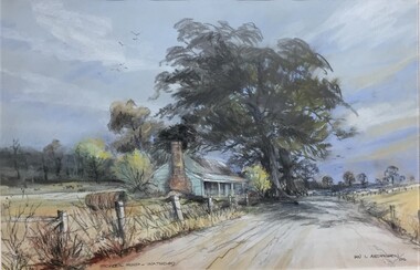
painting, Ian L Anderson, School Road, Waterloo by Ian L Anderson, 1995
significant as a work of art by local Pyrenees artist, locally significant to the Central Highlands Region of Victoria as a representation of local landscape and/or culture pastel drawing of a street scene with old house, trees and unpaved road"Signed: IAN L ANDERSON 95 (lower right) Titled: SCHOOL ROAD - WATERLOO (lower centre) Verso (affixed): ""SCHOOL ROAD - WATERLOO"" PASTEL AND CHARCOAL PENCIL PAINTING by IAN L. ANDERSON 14 MILLAR CRESCENT MT WAVERLEY 3145 signed: Ian Anderson '95 $500" -
 Clunes Museum
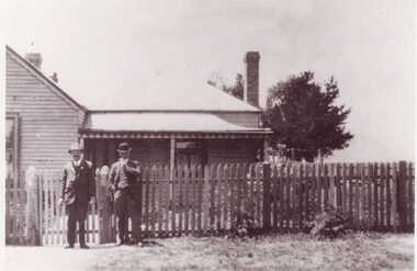
Photograph
BLACK AND WHITE PHOTOGRAPH OF TWO MEN STANDING IN FRONT OF A WEATHER BOARD HOUSE - WOLFENDEN HOUSE. CORNER LESLIE AND SMEATON ROAD CLUNES.HAND WRITTEN IN BLACKLEAD PENCIL WOLFENDEN HOUSE CNR. LESLIE AND SMEATON ROAD.local history, photography, photographs, early citizens -
 Halls Gap & Grampians Historical Society
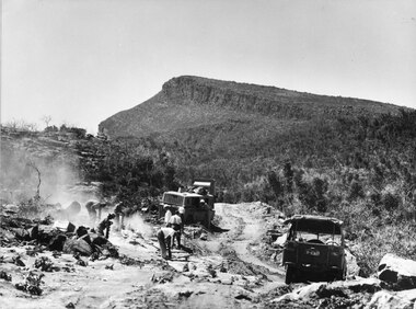
Photograph - B/W
... Roads ...Photo shows men & machinery forming the road up Mt William. There are 8 men, 1 bull-dozer, 1 jeepaccess routes, roads, access routes, mt william road -
 Whitehorse Historical Society Inc.
Photograph - Strip photo/ photocopy, Railway Road Blackburn
East end of Railway Road Blackburn August 1996.Railway Road East end Blackburnrailway road, blackburn, 1976 -
 Anglesea and District Historical Society
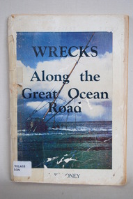
Book, J Loney, Wrecks Along the Great Ocean Road, 1967
Book first published in 1967 dealing with the shipwrecks along the Great Ocean Road. Illustrated with both maps and photographs and with a chrononolgy of the list of wrecks from pre-1800 through to 1958.Title: WRECKS / Along the / Great Ocean / Road J.K. LONEYjack loney, dewey no 910.453, book -
 Melbourne Tram Museum
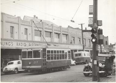
Photograph - Black & White Photograph/s, CLC, early 1950's?
Photograph, Black and White, Birney No. 217 on the Russell St route, Footscray in Barkly St , Cnr Commercial road, just to the west of Geelong Road. Note the tram and bus stop signs on the pole with the traffic lights, and the bus in front of the tram. One of the buildings has an "Ealing's radio electrical sign" Early 1950's?In ink on the rear: "MMTB X217 on Russell Street route at Footscray. / In Barkly St Cnr Commercial Road, immediately west of Geelong Road. / /5" Has KSK number CLC36 in to right hand corner.trams, tramways, footscray, birney, tram stops, bus stops, russell st, barkly st, buses, tram 217 -
 Whitehorse Historical Society Inc.
Map, Nunawading Road District, 01/04/1863
Plan of proposed new road - April 1863 & estimated expenses.Plan of proposed new road - April 1863 & estimated expenses. Scale 20 chains per inch. Proclaimed Roads 149.Plan of proposed new road - April 1863 & estimated expenses.nunawading road district, roads and streets -
![Cotham Road [Kew]](/media/collectors/550653872162f11fb04854aa/items/6132d605e06408664db73aee/item-media/6132d631e06408664db73d5f/item-fit-380x285.jpg) Kew Historical Society Inc
Kew Historical Society IncPhotograph - Cotham Road [Kew], c.1985
... roads ...Original colour positive photograph of the junction of Cotham Road and High Street in Kew, showing businesses of the period, including the Westpac Bank (left), the Greyhound Hotel, Coles and the newsagency (right)"Cotham Rd"cotham road, high street -- kew (vic.), roads -
 Melbourne Tram Museum
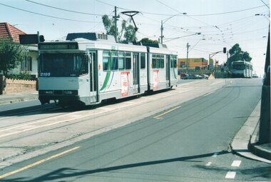
Photograph - Colour Print/s, Colin Rough, 14/03/2003 12:00:00 AM
Colour prints taken by Colin Rough at the North Coburg tram terminus, Sydney Road, 14/3/2003. Tram B2 2105 is waiting on B 2022 to leave. Route 19. Cross street is Bakers Road.On rear in ink various notes about the location and date - 14/3/03, North Coburg Terminus, Sydney Roadtrams, tramways, north coburg, sydney road, route 19, b class, tram 2105, tram 2022 -
 Hymettus Cottage & Garden Ballarat
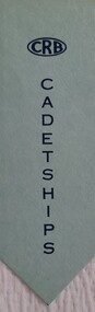
Work on paper - Bookmark, CRB Cadetships
... Roads ...The Country Roads Board was established in 1913 to co-ordinate the construction and maintenance of main roads and bridges and it was abolished in 1983 making way for a new body.crb, roads, victoria -
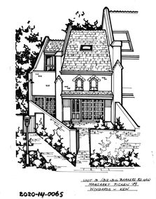 Hawthorn Historical Society
Drawing - Property Illustration, 3/312-316 Barkers Road, Hawthorn
'After training as a Cartographic Draftsman within the mining industry, I worked as a property illustrator for real estate firms in the eastern suburbs of Melbourne for 23 years from 1983. I initially photographed houses with a Polaroid camera and made a 'thumbnail' sketch while there. The photos were used to scale off a sketch in pencil and then that sketch was overlaid with drafting film and the 'pen and ink' completed. The pens I used were the Rotring ‘Rapidigraph’ drafting pens. The ink was also made by Rotring (German).The film was ‘Rapidraw’, polyester drafting film, double matte. It takes a very fine line and doesn’t bleed. As well as house sketches, there were often floor plans and site plans ordered. Aerial sketches were ordered when the property needed an overall view.' (Margaret Picken, 2020)This property illustration is one of a series created by Margaret Picken for a range of real estate agents in Melbourne between c. 1983 and c. 2006. Each work is signed and dated by the artist.Gift of Margaret Picken, 2020Pen and ink property illustration on drafting film of 3/312-316 Barkers Road, Hawthorn by Margaret Picken.Unit 3/312-316 Barkers Road, Haw, Margaret Picken '89. Woodards - Kew.artist - margaret picken 1950- -
 City of Kingston
Pamphlet - Colour, Smith, Nicolson Pty. Ltd, Cheltenham Estate, c. 1890
Sales plan for land in the suburb of Cheltenham, bounded by Point Nepean Road and Swinden Avenue, including Evesham Road and Wallingford Street.The developing urban area of Cheltenham within the City of Kingston. This land sale pamphlet illustrates the subdivision of land within the municipality and the changing demographic of the district as new houses are constructed close to infrastructure.Colour pamphlet advertising for private sale Cheltenham Estate. Incorporates a map of the estate bordered by Point Nepean Road and Swinden Avenue, including Evesham Road, and Wallingford Street.Handwritten in red ink on subdivison 45: D / H Handwritten in red ink on subdivision 46: Anderson Handwritten in red ink on subdivisions 88, 87, 77 and 56: K / D Handwritten in red ink on subdivision 86: D / H Handwritten in red ink on subdivision 63 and 62: Hudson Handwritten in red ink on subdivision 59 [indecipherable] Handwritten in red ink on subdivision 58: aB Handwritten in red ink on subdivision 57: Lavosh Handwritten in grey pencil on subdivision 28, 26, 24, 67, 58, 49: B Handwritten in grey pencil on subdivisions 78 and 79: Paint Handwritten in purple pencil on subdivsion 114 and 86: B land sales, estate, cheltenham -
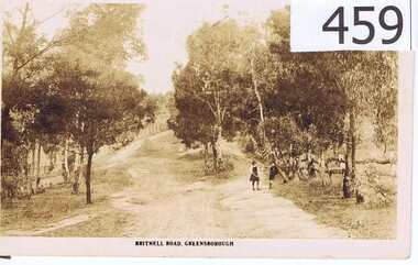 Greensborough Historical Society
Postcard, The Rose Stereographs, Britnell Road, Greensborough, 1920s
This postcard shows us what Britnells Road (now Mountainview Road) looked like in the WW1 era. Britnell Road is a former name of the Mountain View Road section between St Helena Rd and Sherbourne Rodd.A sepia toned postcard featuring a photograph of a rural road scene.2 photo mount remains on rear, nil on front.britnell road, greensborough, mountain view road. -
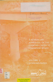 Eltham District Historical Society Inc
Book, A Review and Appraisal of the Diamond Creek to Ringwood Study, volume 2, working paper, by Loder and Bayly, 1979
... Roads ...Volume 2: Working papers. This report is a review and appraisal of the Outer Ring Road Study Diamond Creek to Ringwood prepared for The Road Planning Liaison Committee by the Joint Road Planning Group for the The City of Doncaster & Templestowe and The Shire of Eltham by Loder & Bayly Planning & Engineering Consultants. "This paper attempts to set a framework for an evaluation of the recommended road link between Diamond Creek and Ringwood." Various perspectives are examined. Includes fold out maps.91 p, maps, 27 cm.melbourne ring road, roads, freeways -
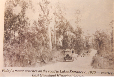 Lakes Entrance Historical Society
Photograph, Foleys motor coaches on the road to Lakes Entrance, 1920 c
Sepia toned photograph showing Foleys motor coaches on road to Lakes Entrance possibly near Bennetts Brook, coach and trailer in front A Ford and trailer behind, tall trees on either side of road, telephone poles on right side. East Gippsland VictoriaFoleys motor coaches on the road to Lakes Entrance c 1920 Courtesy East Gippsland Historical Societytransport -
 Eltham District Historical Society Inc
Slide - Photograph, Bridge Street, Eltham, c.June 1990
... roads ...Intersection of Main Road and Bridge Streets, Eltham. Before reconstruction of Main Road, this intersection had deep cutting embankments on all four corners. Roadworks and private development have levelled the land on the low side of the road. The Eltham War Memorial was originally located on the north western corner. in 1919. 35mm colour positive transparency (1 of 36) Mount - Agfa CS System grey 8 dotsroads, bridge street, eltham -
Whitehorse Historical Society Inc.
Map, Burwood Road, Box Hill City, 15/02/1952 12:00:00 AM
Plan of subdivision of 19 blocks in Burwood Road, Burwood.Plan of subdivision of 19 blocks in Burwood Road, Burwood between Greenwood Street and Middleborough Road. Marked as Survey Plan No 5442.Plan of subdivision of 19 blocks in Burwood Road, Burwood. land subdivision, burwood road, burwood, greenwood street, burwood, middleborough road, burwood -
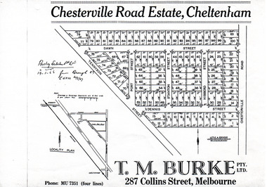 City of Moorabbin Historical Society (Operating the Box Cottage Museum)
Flyer - Chesterville Road Estate, Cheltenham, 1947
Chesterville Road Estate, consisting of 101 building lots, was sold by private sale in late 1947.Example of the progress of the Municipality of MoorabbinPhotocopy of advertising flyer for sale of real estate sales - plan of building blocks for saleChesterville Road Estate, Cheltenham - plan of subdivisiontennyson street, port street, dennis street, station street, dawn street, hubbard street, chesterville road, cheltenham, real estate, auction -
Glenelg Shire Council Cultural Collection
Photograph - Photograph - Road Making, n.d
Port of Portland Authority ArchivesBack: PHT purple stamp. '2/28 252 1.6.54 Breakwater Access Road Re-alignmentport of portland archives, battery point -
 City of Kingston
Pamphlet - Colour, Highett Town, 1888
Sales plan for land in the suburb of Highett, bounded by Highett Road, Worthing Terrace and the railway line, and incorporating Major Street and Train Street.The developing urban area of Highett within the City of Kingston. This land sale pamphlet illustrates the subdivision of land within the municipality and the changing demographic of the district as new houses are constructed close to infrastructure.Colour pamphlet advertising for private sale the Station Entrance Estate, Highett. Incorporates a map of the estate bordered by Wickham Road, Railway Parade, Highett Road and Point Nepean Road.land sales, highett -
 City of Kingston
Pamphlet - Colour, Fergusson & Mitchell Lith, Sandringham Rises, c. 1888
Sales plan for land in the suburb of Sandringham, bounded by Bluff Road, Bay Road and William Street, and incorporating Frances Street.The developing urban area of Highett (then called Sandringham) within the City of Kingston. This land sale pamphlet illustrates the subdivision of land within the municipality and the changing demographic of the district as new houses are constructed close to infrastructure.Colour pamphlet advertising for sale 35 lots in Sandringham Rises, Sandringham. Incorporates a map of the estate bordered by Bluff Road, Bay Road and William Street, including Frances Street.Handwritten in grey pencil next to the words 'THREE O'CLOCK': 1888 Handwritten in blue ben next to the words '& BUSINESS SITES': 1888land sales, sandringham, highett -
 Stawell Historical Society Inc
Photograph, Harris Bridge – Red Bend Road -- Great Western
Harris Bridge – Red Bend Road Great Western.Black & white photo of Bridge. Photo is out of focus so hard to work out.Harris' Bridge Red bend Road Great Westernstawell -
 Eltham District Historical Society Inc
Photograph, Kangaroo Ground - St Andrews Road
... roads ...Five colour photographs of Kangaroo Ground/St Andrews Road, Kangaroo Ground/Panton Hill arearoads, st andrews road, kangaroo ground/st andrews road, panton hill, kangaroo ground -
 Whitehorse Historical Society Inc.
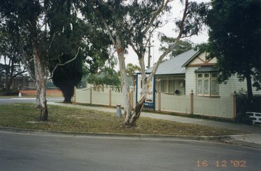
Photograph, Whitehorse Road, Mitcham No.427
427 Whitehorse Road, Mitcham was owned by the Copp family in the 1950s.|See also NP2519-2520 and NP2560, NP3245Coloured photograph of renovated old house at 427 Whitehorse Road, Mitcham, taken in 2002 from Whitehorse Roadwhitehorse road, mitcham no.427 -
 Whitehorse Historical Society Inc.
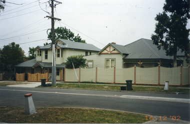
Photograph, Whitehorse Road, Mitcham No.427
427 Whitehorse Road, Mitcham, was owned by the Copp family in the 1950s|See also NP2519-2520 and NP2560, NP3244Coloured photograph of renovated old house at 427 Whitehorse Road, Mitcham, taken in 2002 from Dunlaven Roadwhitehorse road, mitcham no.427 -
 Melton City Libraries
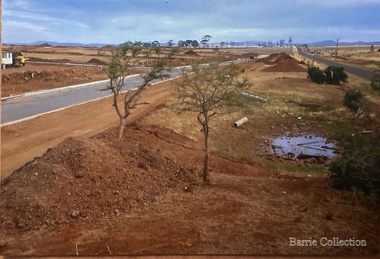
Photograph, West Melton-Coburns Road, 1969
Coburns Road - 19th c family descendents living in Melton. Coburn Primary School Cr George Coburn. 1930’s. December 1935 Shire President Cr Geo Coburn convened meeting to form the Bush Fire Brigade. Road construction of Service road and beginnings of West Melton subdivision. West Melton-Early Division View of Coburns Road. council, local significant events -
 Glen Eira Historical Society
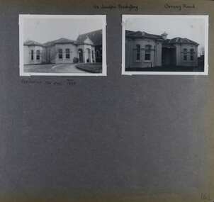
Album - Album page, St Joseph's Presbytery, Orrong Road, Circa 1972
This photograph is part of the Caulfield Historical Album 1972. This album was created in approximately 1972 as part of a project by the Caulfield Historical Society to assist in identifying buildings worthy of preservation. The album is related to a Survey the Caulfield Historical Society developed in collaboration with the National Trust of Australia (Victoria) and Caulfield City Council to identify historic buildings within the City of Caulfield that warranted the protection of a National Trust Classification. Principal photographer thought to be Trevor Hart, member of Caulfield Historical Society. Most photographs were taken between 1966-1972 with a small number of photographs being older and from unknown sources. All photographs are black and white except where stated, with 386 photographs over 198 pages. St Joseph's buildings and grounds are contributory properties to HO72 Elsternwick Estate and environs - City of Glen Eira.Page 162 - two photographs of St Joseph's Presbytery, Orrong Road.Handwritten: St Joseph's Presbytery Orrong Road [top right] / PREVIOUSLY "THE EMS" 1908 [under left photo] / 162 [bottom right]trevor hart, orrong road, curved windows, decorative brackets, arched windows, bay window, portico, slate roof, st joseph's presbytery, catholic church, st joseph's church, st joseph's primary school, porte cochere, the ems, elsternwick, rendered walls, clergy residences, drives, late victorian style, house names -
Glenelg Shire Council Cultural Collection
Photograph - Photograph - Blacknose Quarry Access Road, 29/09/1952
Port of Portland Authority ArchivesFront: 'Blacknose Quarry Access Road 25-9-52 Looking South' printed bottom fram Back: purple PHT stamp -
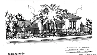 Hawthorn Historical Society
Drawing - Property Illustration, 26 Barkers Road, Hawthorn
'After training as a Cartographic Draftsman within the mining industry, I worked as a property illustrator for real estate firms in the eastern suburbs of Melbourne for 23 years from 1983. I initially photographed houses with a Polaroid camera and made a 'thumbnail' sketch while there. The photos were used to scale off a sketch in pencil and then that sketch was overlaid with drafting film and the 'pen and ink' completed. The pens I used were the Rotring ‘Rapidigraph’ drafting pens. The ink was also made by Rotring (German).The film was ‘Rapidraw’, polyester drafting film, double matte. It takes a very fine line and doesn’t bleed. As well as house sketches, there were often floor plans and site plans ordered. Aerial sketches were ordered when the property needed an overall view.' (Margaret Picken, 2020)This property illustration is one of a series created by Margaret Picken for a range of real estate agents in Melbourne between c. 1983 and c. 2006. Each work is signed and dated by the artist.Gift of Margaret Picken, 2020Pen and ink property illustration on drafting film of 26 Barkers Road, Hawthorn by Margaret Picken.26 Barkers Road, Hawthorn, Margaret Picken '90. Woodards - Hawthorn, rear 35 Elm T, Hawartist - margaret picken 1950- -
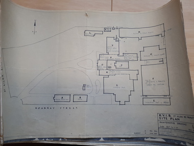 Vision Australia
Plan - Image, RVIB Maintenance drawing, April 1963 - November 1966
A series of maintenance drawings were made or copied by an architectural firm. These plans include: 1 - St Kilda Road Property - a site map of the buildings and grounds with the names of the various areas added. 2 - St Kilda Road Central Building (copied from a RAAF drawing) showing rooms on the ground floor. 3 - St Kilda Road Central Building (copied from a RAAF drawing) showing rooms on the first floor. 4 - St Kilda Road Central Building roof plan. 5 - St Kilda Road Factories showing the layout on the ground floor. 6 - St Kilda Road Factories showing the layout on the first floor. 7 - St Kilda Road building showing all three floors of the building rented out to Alfred Hospital. 8 - St Kilda Road caretaker, factory, fundraising and rehabilitation training buildings. 9 - Raleigh Street, Prahran hostel layout for both girls and boys.9 pages of plans of buildings on St Kilda road siteVarious - see individual plansmyer house, royal victorian institute for the blind, plans, raleigh street hostel, alfred hospital