Showing 659 items matching " survey plan"
-
 Canterbury History Group
Book, Allom Lovell Sanderson Pty Ltd, Conservation Management Plan, Frognall Canterbury Vic. Vol 1
Contains the conservation analysis and broad conservation management plan as well as a description of the physical condition of the buildings for RAAF Frognall.canterbury, mont abert road, frognall, verulan, mountfield, gall> james, towers, stables, staircases, royal australian air force, city of camberwell, elgar's special survey -
University of Melbourne, Burnley Campus Archives
Plan, Horticultural Project Conservation and Management Plan Wombat Park, 1994
Photocopies of plan drawn by M. Gilbert of Survey Area C-G, with numbered plant list. (Miffy Gilbert's final thesis, 1994, Conservation Analysis & Management Plan Wombat Park Daylesford - see AGHS website)m. gilbert, wombat park, management plan, daylesford, gardens, plant list -
 Bendigo Military Museum
Administrative record - Royal Australian Survey Corps - Planning for Field Survey Operations for 1:250,000 - LtCol JK Herridge (RASvy) 1960, LtCol JB Herridge (RASvy), April 1960
... This 13 x page document contains notes on planning... - Planning for Field Survey Operations for 1:250,000 - LtCol JK ...This 13 x page document contains notes on planning for RASvy Field Survey Operations in Northern Command during 1958 and 1959 with helicopter support available for field operations for 1:250,000 mapping. The Document was written by LtCol JB Herridge (RASvy) at the School of Military Survey Balcombe April 1960.13 x foolscap pages of typed text, stapled and four holed punchedHand written "53" in top RH cornerroyal australian survey corps, rasvy, fortuna, army survey regiment, army svy regt, asr, school of military survey, sms -
 Ringwood and District Historical Society
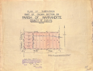
Map - Plan of Subdivision, Part of Crown Section 24, Parish of Warrandyte, County of Evelyn - 1951
Survey map of residential allotments in Berringa Road and Milne Road, Park Orchards, Victoria. Russell Francis Kinnane, Licensed Surveyor, 4th October, 1951. -
 Ringwood and District Historical Society
Map - Plan of Subdivision, Part of Crown Section 24, Parish of Warrandyte, County of Evelyn - undated, circa 1951
Survey map of residential allotments in Milne Road, east of Berringa Road, Park Orchards, Victoria. -
 Bendigo Historical Society Inc.
Map - LOCAL AREA PLANS, See above
Map: Compilation of maps: Village of Redcastle dated april 14 1861, Township of Yarraberb dated 14 July 1874, Hamlet of White Hills dated December 27 1872, Road survey of Toolleenmap, parish plan, redcastle, yarraberb, white hills, toolleen -
 Ballarat Heritage Services
Photograph - Photograph - Colour, Flag of St Alipius', Ballarat East, 2004, 23/09/2004
"Centenary of Fnrst Mass at Ballarat Friday last marked the centenary of the arrival of the first priest and the celebration of the first Mass in Ballarat. The Rev. Patrick Dunne reached the diggings on October 17, and on Sunday, October 19, 1851, in a bark hut near Brown Hill, he celebrated Mass. Worshippers had to kneel on quartz gravel. The weather had been the worst experienced in Victoria for a number of years, and most of the creeks between Melbourne and Ballarat were flowing torrents, but Father Dunne (who came from the Coburg mission), carrying the barest necessities and the sacred vestments, set out for Ballarat on horseback. He had to ford and swim his horse across the creeks. When most of his congregation left for the Castlemaine diggings Father Dunne returned to Melbourne. In August, 1852, Rev. Matthew Downing became Ballarat's first resident priest. He built a large wooden structure with a canvas roof which served as a church, but later erected at the Gravel Pits the first permanent church. This church was the largest of any house of worship on any goldfield in the colony. It cost £ 100, contributed solely by Father Downing and his flock. Soon after he got the authorities to survey a large piece of land at the back of the township as a burial ground and procured a grant of £500 for fencing it. A grant of £250 was also obtained for the improvement of the chapel and fittings of a school, where Michael Campion Carey opened the first school. Rev. Patrick Smyth succeeded Father Downing, who was followed by Rev. P. Madden, who in 1857 began to plan the erection of St. Patrick's Church. The foundation stone of this was laid by Bishop Goold on February 12, 1858, and the church was opened for the first time on November 8, 1863." (Melbourne Advocate 25 October 1951)Two colour photographs showing the St Alipius' Catholic Church flag - a blue cross and border on white. st alipius, church, ballarat east, flag -
University of Melbourne, Burnley Campus Archives
Plan, Alton-Hascombe Feature Survey, c. 1990
... Feature Survey Plan ...1 tracing paper and 2 paper copies of plan by Department of Conservation, Forests and Lands, Division of Survey and Mapping, of adjoining gardens Alton and Hascombe at Mount Macedon, Victoria. Scale 1:1000. Plan of properties includes buildings, gardens and paddocks. 1 copy has significant buildings coloured.feature survey, mount macedon, gardens, alton, hascombe -
University of Melbourne, Burnley Campus Archives
Plan, Glenferrie PR. S. No. 1508: Detail Survey, 1982
... . No. 1508: Detail Survey Plan ...Original and 2 copies of Public Works Department, Victoria plans of Glenferrie Primary School for the Department of Education SU 2241.2. Shows site plan of area bounded by Manningtree Road and Wattle Road. Pit Schedule of storm water and sewer pits.glenferre primary school, survey, victoria public works department, storm water, trees, p. manley (draftsman) -
Bialik College
Document (series) - Box of strategic planning booklets and documents
strategy, elc, religion, 2000s, 1990s, 1980s, 2010s, promotionstrategy, elc, religion, 2000s, 1990s, 1980s, 2010s, promotion -
Surrey Hills Historical Society Collection
Work on paper - Vertical file, Cragg, Thomas
A vertical file containing the following information: 1. Extract from research of Alan Holt re Elgar Survey (Holt file 28): Memorandum of agreement 14.3.1882 and plan (3 pages). -
 University of Melbourne, Burnley Campus Archives
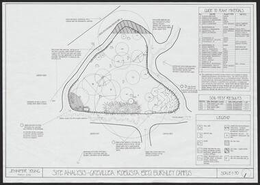
Plan, Jennifer Young, Grevillea Robusta Bed Burnley Campus, 2006
(1) Site Analysis by Jennifer Young, March 2006. (2) Plant Survey by Jennifer Young, March 2006. (3) Plant Plan - photocopy of rough hand-drawn planjennifer young, grevillea robusta, burnley horticultural college, landscaping, soil types -
 Linton and District Historical Society Inc
Mining survey document, Mining Survey Document, 1890
Document drawn up in relation to an application for a mining lease made by Isaac Walker of Linton. Application no. PP16, Lease no. 1351. Application was made for a mining lease on land in Sussex Street, Linton, which was occupied by Sarah Dawe and family. Original document is held at PROV Ballarat. Item and series details are recorded in handwriting on the lower part of the document.Photocopy of original document, which shows a plan of Allotments 3 & 4, Section 1A, Township of Linton, Parish of Argyle.mining applications, mining leases, plans, documents, isaac walker, dawe family, sarah dawe née carpenter -
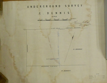 Bendigo Historical Society Inc.
Plan - MARKS COLLECTION: PLAN OF UNDERGROUND SURVEY G. DENNIS MINE
... MARKS COLLECTION: PLAN OF UNDERGROUND SURVEY G. DENNIS MINE... parchment 'underground survey G. Dennis' printed on top of plan ...Plan drawn on heavy parchment 'underground survey G. Dennis' printed on top of plan. Plan shows boundary lines and peg site. P. Bonati claim marked on bottom of plan. B. Letter with plan on letterhead 'City of Sandhurst, Town Hall, July 2nd. 1873' Addressed to Mr. George Dennis, Sir, In reply to your letter of the 19th. ulto I am empowered to state that subject to the formation of the road referred to, your existing rights are conserved, and the council will undertake not to object to the renewal of your lease. The only conditions being that you shall not sink a shaft in the street or attempt to obstruct it when formed. I have the honor to be, Sir, your obedient servant, Geo Fletcher, Town Clerk.bendigo, mining, g. dennis claim -
 Bendigo Historical Society Inc.
Plan - FORTUNA COLLECTION: FORTUNA VILLA
Originally built by Christopher Ballestedt (1796-1869) and his son Theodore. The Ballestedt's pioneered open cut and quartz mining on the Bendigo gold field. They were very successful. After Christopher's death, Theodore continued until 1871 when he sold Fortuna, their mines and equipment to George Lansell for 30,000 pounds.Four large plans of Fortuna villa. Scale 1:50 Australian survey office - Victoria Department of Administrative services. Fortuna Bendigo - Army Survey Regiment. Dept. of Defence - Army. Terrestrial Photogrammetric Survey. Project number: 8001/2. Reg. File: 64/531. Survey File:631. Draftsman: M.A. Osciak. Surveyed by G. Tucker. Date of Survey: 14/05/79. There are 4 large such plans in a plastic bag the measurement of the plans is approx. 115cm X 80 cm.plan, bendigo, fortuna villa -
 Ringwood and District Historical Society
Document - Map, Plan of Subdivision - Part of Crown Allotments 14A & 14C, Parish of Ringwood, County of Mornington, Vol 5378 Fol 511 - 1927
Department of Lands and Survey photocopy dated 17/1/1951, page number 12308.Map includes Canterbury Road, Heathmont Road, Dickasons Road, Bennett Avenue, Orchid Street and Allens Road, Heathmont, Vic. -
University of Melbourne, Burnley Campus Archives
Plan, Royal Botanic Gardens Melbourne, 1978
Plan of RBG with grid references. Produced by Dept. of Crown Lands and Survey, Victoria, Division of Survey and Mapping. Prepared in 1978 from surveys completed in 1976. (1) 2 copies plan. Main areas, buildings, etc., labelled, beds outlined. (2) Original coloured plan and reduced size photocopy. More labelling, particularly beds (handwritten). Labelled Jeremy J. Wallace with handwritten notes on reverse re a project. (3) Reduced size photocopy. Handwritten labelling of beds. (4 - 11) Enlarged photocopies of sections of (1) Handwritten notes and plant labelling. (1). Photgraphed copies by FRESCO 510131-TA. (12) Plan on a grid, coloured. "No Public Access," areas marked.jeremy j. wallace, royal botanical gardens melbourne, department of crown land and survey division of survey and mapping, ornamental lakes -
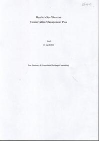 Bendigo Historical Society Inc.
Document - HUSTLERS REEF RESERVE CONSERVATION MANAGEMENT PLAN
Conservation management plan (112 pages) prepared by Lee Andrews & Associates, Heritage Consultants, in 2011, for the Hustlers Reef Reserve. The reserve cover the site of the former Great Extended Hustlers Mine site. Leigh McKinnons amendments to the plan are included with the document. History of the site, a physical survey and analysis, comparative analysis, cultural significance and conservation policy are addressed in the document.bendigo, mining, great extended hustlers mine site -
 Bendigo Historical Society Inc.
Document - HUSTLERS REEF - PLANS & SECTIONS TO ACCOMPANY BULLETIN NO 33
Pink page pasted onto cream card titled Plans and Sections to accompany Bulletin No 33. Hustler's Line of Reef, Bendigo by H S Whitelaw, by Authority: Albert J. Mullett, Government Printer, Melbourne. Plate No 1 to No 34. Mines mentioned: Fortuna Hustler's Mine, Hustler's Royal Reserve No 2 Mine, Hustler's Royal Reserve Mine Park Shaft, Great Extended Hustler's Mine, Hustler's Reef and Hustler's Reef No 1 Mines, Hustler's Reef Mine, Comet Mine, United Hustler's and Redan Mine, K. K. Mine, Hustler's Consols Mine, Fortuna Hustler's Mine. Department of Mines Geological Survey of Victoria 1914. Written on the back: Lightning Hill area to Summer Hill.document, hustlers reef, plans & sections to accompany bulletin no 33, geological survey of victoria, department of mines, hustler's line of reef, h s whitelaw, fortuna hustler's mine, hustler's royal reserve no 2 mine, hustler's royal reserve mine park shaft, great extended hustler's mine, hustler's reef mine, hustler's reef no 1 mine, comet mine, united hustler's mine, redan mine, k k mine, hustler's consols mine, fortuna hustler's mine, hustler's consols mine, albert j mullett, government printer melbourne -
 Bendigo Historical Society Inc.
Map - GREAT EXTENDED HUSTLER'S MINE - PLAN OF THE GREAT EXTENDED HUSTLER'S MINE
Plan of the Great Extended Hustler's Mine on the Hustler's Line of Reefs, Bendigo. Bulletin No 33, Plate No X. Lease No 7382. Plan has map of streets. Mine was located in the block bounded by Langston and Anderson Streets and was between the Hustler's Anticline at Surface and the Lightning Hill Anticline at Surface. Latham & Watson's Shaft is also mentioned. Levels are numbered and a table shows the Levels and their Depths. Geological Survey of Victoria. Signed by H A Whitelaw, Underground Survey Office, Bendigo, September 1913. This item has not been scanned or photographed.mining, parish map, great extended hustler's mine, hustler's line of reefs, mining lease no 7382, geological survey of victoria, underground survey office bendigo, h a whitelaw, latham & watson's shaft -
 Bendigo Historical Society Inc.
Map - GREAT EXTENDED HUSTLER'S MINE - PLAN OF THE GREAT EXTENDED HUSTLER'S MINE
Plan of the Great Extended Hustler's Mine. Bulletin No 33, Plate No XI. Shows No 2 Shaft, Latham & Watson's Shaft, levels and their depths and some geographical features. Geographical Survey of Victoria emblem and signed by H A Whitelaw, Underground Survey Office, Bendigo, September 1913. Has reference to photos.mining, parish map, great extended hustler's mine, no 2 shaft, latham & watson's shaft, geological survey of victoria, underground survey office bendigo, h a whitelaw -
 Bendigo Historical Society Inc.
Map - FORTUNA HUSTLER'S MINE - PLAN OF THE FORTUNA HUSTLER'S MINE
... Underground Survey Office Bendigo Plan of the Fortuna Hustler's Mine ...Plan of the Fortuna Hustler's Mine, Bulletin No 33, Plate No II. Geological Survey of Victoria. Signed by H A Whitelaw, Underground Survey Office Bendigo, September 1913. Map shows levels and depths. There are smaller drawings of some sections of some levels. mining, parish map, fortuna hustler's mine, plan of the fortuna hustler's mine, geological survey of victoria, h a whitelaw, underground survey office bendigo -
University of Melbourne, Burnley Campus Archives
Plan - Photocopy, Proposed Reserve for Horticultural and Experimental Garden in the Survey Paddock Richmond, 1862-1948
... burnley Horticultural and Experimental Garden Survey ...Photocopy of Plan Gazetted 01.08.1863. From Central Plan Office Department of Natural Resources.Original signed by Clement Hodgkinson, Deputy Surveyor General. Stamped Department of Lands and Survey 7.12.48 Neg.18377. Handwritten notes on back "Melb Roll 23, R.19(A)"burnley, horticultural and experimental garden, survey paddock, richmond, clement hodgkinson -
University of Melbourne, Burnley Campus Archives
Plan, Horticultural & Experimental Garden in the Survey Paddock Richmond, 1862
... . Horticultural & Experimental Garden in the Survey Paddock Richmond Plan ...Plan of site with area drawn in. From Office Dept. of Natural Resources.Handwritten on original: "To accompany letter from the Hon. Sec. of the Horticultural Society of Victoria to the Hon. The President of the Board of Land Works. A. Purchas, C.E. 9 October 1862 R 19 A1." and "Memo: The trees to be planted 50 feet apart in each row. AP"burnley, horticultural society of victoria -
 Bendigo Historical Society Inc.
Document - Geological Survey of Victoria, Hustlers Line of Reef, Bendigo, April, 2014
Seven men were killed at the Great Extended Hustler's mine disaster on 2nd May 1914 by an explosion of dynamite occurring as the men were waiting at the plat to ascend the mine at the end of their shift. No blame was attached to anyone in the findings of the inquisition. It was unknown what caused the dynamite to explode. This document formed part of the research done at the time by Bendigo Historical Society, of the 100 years commemoration of the mine disaster, held at Hustler's Hill in 2014. Seven page photocopy of Department of Mines, Bulletin, Geological Survey of Victoria, Hustlers Line of Reef, Bendigo, No. 33 by H.S. Whitelaw. Includes plan of Hustlers Royal Reserve No. 2, (main shaft) showing location on Pall Mall, and location of Post Office and Law Courts; plan of location of Hustlers Royal Reserve No. 2 (Park Shaft) showing Jail (sic), Camp Hill State School, two 'lagoons' in between tennis court, croquet court and bowling green; a plan of the Great Extended Hustler's Shaft and two copied images of Hustler's Hill showing mining buildings, poppet heads and chimneys. Comet, K.K., Hustler's No. 1, Old Comet and United Hustler's and Redan Mines are shown in the images. great extended hustlers, goldmining, accident, quartz, mining, k.k. mine, comet mine, hustler's line of reef, old comet, united hustler's, redan -
 Bendigo Historical Society Inc.
Letter - MERLE HALL COLLECTION: ROSALIND PARK CREATIVE VILLAGE BENDIGO PROJECT LETTERS, 1995
MERLE HALL COLLECTION: ROSALIND PARK CREATIVE VILLAGE BENDIGO PROJECT LETTERS Merle Hall Collection: Rosalind Park Creative Village Bendigo Project Letters from Maery Hall (Gabriel). 6 December 1995 To: Merle Hall Arts Bendigo From Maery Hall Content: Outline of what is involved in the design and working of the project. Enclosed are three page of the design outline, one page of tool drawings, three sheets of sketches, photograph of small mosaic sketch using rocks I brought back from my last visit. The letter also contains: Materials, Tools, labour, other needs, Time, Costs and the Council’s role. 6 November 1995 To: Merle Hall Secretary Arts Bendigo From Maery Hall Content: Contains a rough sketch of the project. Note that the sketch is missing. 29 January 1997 To: Merle Hall Arts Bendigo From Maery Gabriel Content: Contains a drawing for the remaining pavement areas that I submitted before and measurements for the actual slabs for 22 square m. for the two. The result will be 2 (saddle reefs) in style. Also mentioned are two options for payment. Receipts also included for the last two payments and the saw. Thank you for sending the form of transfer for the saw. (Note the drawing is missing) 10 April 1997 To: Merle Hall Arts Bendigo From Maery Gabriel (artist in Mosaic) Content: Thank you for your letter of 9 March and further discussions on costs and layouts. 25 Feb 1997 To: Maery Gabrel, ‘Morningswood’ Peterson’s Road Ellinbank 3821 From Merle Hall Secretary Arts Bendigo Content: Apologies for the delay in not answering last letters and drawings. Mentions the need to meet with the Council to discuss the completion of the project and the need to enquire about funding from the Premier’s ‘community support fund’ 9 March 1997 To: Maery Gabrel From Merle Hall Secretary Arts Bendigo Content: Follow-up letter from 25 Feb 1997 concerning the last sections of the mosaic project. Outcome of meeting with Bernard Smith of the City of Greater Bendigo One local business sponsor prepared to donate a small amount towards completion of the project P.S. Sharon Hackett: the painter would love to receive her questionnaire from you. 22 Dec 1996 To: Maery Gabrel From Merle Hall Secretary Arts Bendigo Content: Enclosed is a form to cover transfer of ownership of the diamond saw as recommended by an adviser. P.S. the transfer is made out to ‘Hall’ - your name under our contracts. I’ve used your name for the address. 20 Dec 1996 To: Maery Gabrel From Merle Hall Secretary Arts Bendigo Content: Arts Bendigo Inc. of P.O. Box 563, Bendigo, 3552, agrees to the transfer of ownership to Maery Hall of ‘Morningswood’, Peterson’s Rd., Ellinbank, 3821 of one ‘Stubbie electric Bricksaw. Purchased from DEMBICON on May 25th, 1996 Diamond Blade for $1650, now valued at $1200 Part payment for the contractor of a mosaic pavement around the poppet lookout in Rosalind Park Bendigo. 30 Nov 1995 To: Maery Gabrel From Merle Hall Secretary Arts Bendigo Content: The enclosed survey sketches just arrived. Formal approval from the commissioners. Early next year the poppet head will be re-painted and have scaffolding there for a time but shouldn’t be a problem. 9 January 1996 To: Maery Gabrel From Merle Hall Secretary Arts Bendigo Content: Summary of discussions with the John Little V.A.C. and Roni Schell from ‘Future Connections’ re her DEET submission and Bernard King from the City and one of the Commisioners. A non-specific plan for being ‘contracted and not employed’ An expectation the ‘Future Connections’ would then offer you separate contract to conduct workshops for their clients and develop tutorials. 9 November 1995 To: Maery Hall From Merle Hall Secretary Arts Bendigo Content: Sketches enclosed for the poppet head site and comments on them from the City Council. 20 January 1997 From: Maery Gabiel Artist in Mosaic (formerly Maery Hall) To: Merle Hall Secretary Arts Bendigo Content: Receipt of $5000 plus one ‘Stubbie Electric Bricksaw, with stand, serial number 0002056 being payment under contract no. 2 for work on mosaic payments in Bendigo. 20 May 1996 List of Materials and equipment required for Mosaic and tools to be mademaery hall, arts bendigo -
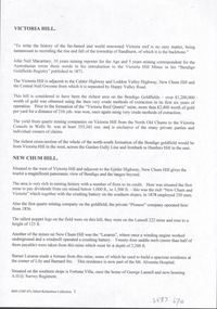 Bendigo Historical Society Inc.
Document - VICTORIA HILL - VICTORIA HILL AND NEW CHUM HILL
Typed notes on Victoria Hill and New Chum Hill. Notes give location, value of gold and plans for a mining museum.document, gold, victoria hill, victoria hill and new chum hill, john neil macartney, the age, the australasian, bendigo goldfields registry 1871, victoria reef quartz mine, north old chum, victoria consols, new chum and victoria, pioneer, lansell 222 mine, lazarus, barnet lazarus, mt. alvernia hospital, fortuna villa, george lansell, a. h. q. survey regiment, central red white and blue, hudsons, burrowes & sterry, b c v channel 8, bendigo and district tourist association, section 14 of the lands act 1958, mr a r richardson, cr t r flood, tourist association -
 Monbulk RSL Sub Branch
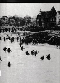
Book, Time-Life Books, The second front, 1977
... overlord Text and photographs survey the planning and execution ...Text and photographs survey the planning and execution of Operation Overlord, the Allied invasion of Germanoccupied Europe on June 6, 1944.Index, bib, ill, , maps, p.208.non-fictionText and photographs survey the planning and execution of Operation Overlord, the Allied invasion of Germanoccupied Europe on June 6, 1944.world war 1939-1945 - campaigns - western europe, operation overlord -
University of Melbourne, Burnley Campus Archives
Plan, Plan of Richmond Park, 1872
... and Survey, 6th Sept. 1872. Plan of Richmond Park Plan ...Plan of Richmond Park L4461. Shows Horticultural Society's Garden without extra land used for Field Station (see 11.0363, but earlier). Surveyed and drawn by A.L. Martin, Authorized Surveyor. Photo-lithographed at the Department of Lands and Survey, 6th Sept. 1872.Handwritten notes on reverse and another railway line marked in pencil.railway lines, swan street, yarra river, richmond park, horticultural society, orchard -
 University of Melbourne, Burnley Campus Archives
Plan, Plan of Richmond Park, 1886-1948
(1) Black and white photographed copy of an original coloured plan. Plan of Richmond Park with Horticultural Society Gardens marked in. Includes additional land which became the Field Station. Original plan dated 31 August 1872, note of Crown Grant to the Board of Land & Works and Richmond City Council 1886; showing land, "Permanently Preserved for the Gardens". Stamp, "Department of Lands and Survey Photographed at the Central Plan Office 1/1 Plate 7.12.48" (2) Also 2 photocopies, 1 reduced - possibly used in a publication1 photocopy has "Figure 1. Plan of Burnley Gardens circa 1863 [sic]gardens, richmond, horticultural society of victoria, richmond park, a.l. martin