Showing 1004 items
matching w north
-
 Bendigo Historical Society Inc.
Map - LANSELL'S BIG 180 MINE - LOCALITY OF LANSELL'S NO 180 SHAFT
Buff coloured photocopy of the location of Lansell's No 180 Shaft and showing the positions of Underground Workings near the intersection of Lily St and Alley St. Also mentioned are the North Old Chum Shaft and the New Chum and Victoria Co Shaft. Luffman Brothers has been written in in pen and initialled A R. Printed at the bottom is: Surveyed by E. T. Brown, under the direction of A. W. Howitt, Secretary for Mines for the - (the rest is cut off).map, bendigo, mining plan, lansell's big 180 mine, locality of lansell's no 180 shaft, north old chum co shaft, new chum and victoria co shaft, luffman brothers, e t brown, a w howitt -
 Bendigo Historical Society Inc.
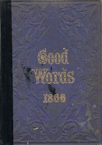
Book - GOOD WORDS 1866
A damaged hard covered book titled ''Good Words 1866.'' Edited by Norman Macleod, D.D. 'one of Her Majesty's chaplains for Scotland.'' Illustrated by J. Wolf, R.P. Leitch, W. Small, G.J. Pinwell, A.B. Houghton, J.W. North, M.E. Edwards, and others. Strahan & Co., Magazine Publishers, London and New York. 858p. Ill. 1866.Norman Macleod, Editorbooks, collections, essays, books, book, non fiction, essays, illustrations, poetry, collections, fiction, literature -
 Bendigo Historical Society Inc.
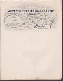
Document - CAMBRIDGE PRESS COLLECTION: LETTERHEAD - ADVANCE BENDIGO AND THE NORTH LEAGUE
... Advance Bendigo and the North League Cr W H Taylor Cr G D Garvin ...Advance Bendigo and the North League, Allan's Walk, Pall Mall, Bendigo. Letterhead printed in dark blue and grey. At the top are sun rays above a cloud? On the right it has a map showing Bendigo and a large area to the North, North East and North West. On the left is an oval shape with the names of the Patron, His Worship the Mayor of Bendigo Cr. W. H. Taylor, President: Cr. G. D. Garvin, J.P., Vice-President W. Cowling, Esq, Executive Committee, Cr. J. Michelsen, J. L. Shoosmith, Cr. W. H. Taylor, J. Jeffrey, Dr. A. Beischer, C. L. Stilwell,A. L. Bolton O.B.E., W. Wallace, Lt. Col. G. V. Lansell, M.L.C.business, printers, cambridge press, cambridge press collection, advance bendigo and the north league, cr w h taylor, cr g d garvin j.p., w cowling, c m dawe, cr j michelsen, j l shoosmith, cr w h taylor, j jeffrey, dr a beischer, c l stillwell, a l bolton o.b.e., w wallace, lt col g v lansell m.l.c. -
 Bendigo Historical Society Inc.
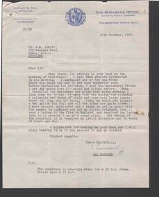
Document - BILL ASHMAN COLLECTION: CORRESPONDENCE
... - Correspondence Palmerston North City Council Dr W N Abbott J Hearmsuth ...Letter, dated 28 October, 1947, from J. Hearmsuth? To Dr. W. N. Abbott. The writer thanks Dr. Abbott for sending him the book on the working of Scalebuoys. The one installed at the Gas Works had done wonderful work and they required very little attention.sciences, instruments - general, scalebuoy, bill ashman collection - correspondence, palmerston north city council, dr w n abbott, j hearmsuth? -
Port Melbourne Historical & Preservation Society
Container - Bottle, W H Dawbarn & Son, Port Melbourne, Aire & Calder Co, c. 1885
Dug from Browns Hill tip, North Melbourne, purchased by Peter LIbbis at Bottle Fair in 1998. Refer photo of Bay Street Dawbarn's factory, item 13.11Soda bottle with stopper, pale green glass inscribed ' W.H. Dawbarn & Son, Port Melbourne' and also 'Brieffits', 'Aire & Calder Co. Makers, London' John Lamont pattern c1885 base inscribed 'Breffit's bottle'As descriptionindustry - manufacturing, w h dawbarn & son -
Port Melbourne Historical & Preservation Society
Photograph - Ken Turner, age one, in Nott Street, Port Melbourne, 1920s
B&W lasercopy, one of five on a page of photos of Bert Turner family of Nott Street: Ken Turner, age one, in Nott Street. In the background can be seen the doctor's surgery/home at 141 Bridge St. (south-east corner of Nott St.) and the grocer shop and residence at 180-2 Nott St (north-east corner of Bridge St.)domestic life, built environment - domestic, bert turner, lily norton turner -
Port Melbourne Historical & Preservation Society
Photograph - Tug, Howard Smith at No 4 North Wharf, c. 1960
Photo of the tug Howard Smith laying at No 4 North Wharf between jobs (2 prints: one colour, one B&W)transport - shipping, howard smith - tug -
Port Melbourne Historical & Preservation Society
Map - West and North Melbourne, MMBW, 21 Feb 1936
Melbourne and Metropolitan Board of Works plan No 24 of West and North Melbourne Docklands,1936signed A.W. Walkermmbw, melbourne and metropolitan board of works, a w walker -
Port Melbourne Historical & Preservation Society
Photograph - Bruno, Joe, Teresa and Tony Cannatelli sitting on the bonnet of a Ford Falcon, Bay Street, Port Melbourne, 1969
B&W photo of Bruno, Joe, Teresa and Tony Cannatelli sitting on the bonnet of a Ford Falcon, north side of Bay Street, outside Faram's, near Raglan Street, 1967built environment - commercial, transport - motor vehicles, antonio cannatelli, joe cannatelli, bruno cannatelli, teresa cannatelli -
Port Melbourne Historical & Preservation Society
Photograph - Bay Street, Port Melbourne from the North East, Charles Nettleton, 1875 - 87
On City of Port Phillip CD ROMCOPYRIGHT CITY OF PORT PHILLIP. Image taken from City of Port Phillip CD-ROM B&W photo of Bay St from the North East 1875-85. In the background are many masted ships at Town Pier and Railway Pierbuilt environment - commercial, piers and wharves, business and traders, cohen & marks, london & dublin loan office, cheap boot and shoe store, bay street -
 Port Melbourne Historical & Preservation Society
Photograph - View from north, Excelsior Hall, Port Melbourne, Gary Spivak, 2000
Taken by Gary Spivak, an officer of the City of Port Phillip involved with the reconstruction of heritage buildings to create low cost housing. this project was under his direction.B&W photos of Excelsior Hall 2003, prior to redevelopment into units 13 - view of hall from Northbuilt environment - civic, town planning, heritage, excelsior hall, rsl, returned services league -
Port Melbourne Historical & Preservation Society
Photograph - Railway reserve, looking from Bridge Street, Port Melbourne towards the city, 1950s
B&W photo of the railway reserve, looking from Bridge St towards the city. North Port Station is in the centre, Albion Hotel and Dunlop on the left. A large plantation of elm trees is on the left. CoPP image.transport - railways, parks and gardens, north port railway station, dunlop, albion hotel, railway reserve -
Port Melbourne Historical & Preservation Society
Photograph - Photograph board, Seven aerial views of J Kitchen & Sons site, Port Melbourne, J Kitchen & Sons Pty Ltd. Port Melbourne 1951, 1951
Large brown cardboard with seven (7) B&W aerial photographs pasted on it. Taken in 1951. Photo 1 - South East direction with Boundary Street in foreground, Kitchens buildings and Football Ground (cricket being played) Photo 2 - South West direction towards the Bay showing Station and Princes Piers, with ships in the distance. Photo 3 - almost directly above Kitchens Photo 4 - directly above kitchens Photo 5 - looking West including the Yarra River Photo 6 - looking North with Kitchen's storage and football ground in foreground Photo 7 - looking north east with football ground in foregrpound left and Yarra River top right.industry - manufacturing, built environment - industrial, piers and wharves - princes pier, piers and wharves - station pier, sport - australian rules football, sport - cricket, sport - recreational grounds, j kitchen & sons pty ltd, port melbourne football and cricket ground, north port oval -
Port Melbourne Historical & Preservation Society
Document - Ticket, Port Melbourne Railway United Football Club, 1938
1938 Season ticket for the Port Melbourne Railway United Football Club (Port second eighteen), sponsored by the Railway Hotel in Raglan Street near North Port station.'Mr J Wilson'archibald (arch) todd, sport - australian rules football, hotels, j wilson, r frawley, thomas griffin, d l hart, l potter, e danziger, r kent, j reynolds, j le clercqq, james edward earl, michael thomas woodruff, j woodruff jnr, r powell, a summers, c ware snr, miss a frawley, w conthwaite, d mitchell, j smith, port melbourne railway united football club, port melbourne junior football club, railway club hotel -
Port Melbourne Historical & Preservation Society
Photograph - Graham Street overpass nearing completion, Port Melbourne, Douglas Smallpage, 1970
B&W photograph - Graham Street overpass nearing completion, viewed from north. Opened early 1971engineering - bridges, centenary bridge -
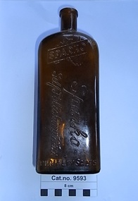 Coal Creek Community Park & Museum
Bottle, glass, c. 1942-1951
TROVE : Weekly Times (Melbourne, Vic. : 1869 - 1954), Wednesday 17 June 1942, page 13 '…………… CHANDLER'S for Better Value!............ "SPARKO" SELF POLISHING WAX . . . . at 1/- large bottle…... (D. & W. CHANDLER LTD.) 276 BRUNSWICK STREET, FITZROY. J4145 (7 lines) 234 FLINDERS LANE, MELBOURNE. T4175 (4 lines) VICTORIA MARKET, BALLARAT. COLAC, HORSHAM, WANGARATTA, WARRNAMBOOL'. TROVE :Age (Melbourne, Vic. : 1854 - 1954), Saturday 15 September 1951, page 28 ‘…… TRAVELLERS calling on country stores in Victoria. We have an excellent line. Apply Sparko Speciality Sales Service, 17 Perry-street, Collingwood. JA3042. — TRAVELLERS, calling north of the river, we have additional lines, contact Sparko Specialty Sales Service, 17 Perry-street, Collingwood. JA3042……………………’ Brown rectangular bottle for stopper seal, with ridged pattern of ridges on both sides and back. Text embossed around base , on two sides at the shoulder, on the front side and on base.Embossed on rear shoulder 'POISONOUS NOT TO BE TAKEN', running around the four sides at bottom 'THE PROPERTY OF SPARKO SPECIALITY SALES SERVICE', on front at shoulder, a logo of a silhouette of Australia with a band diagonally across containing the word 'SPARKO'. on front running down the bottle 'Sparko Self Polishing Wax'. On base AGM logo, 'F451', 'D45', 'M. on edge of base '34A' in mirror text. -
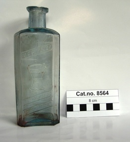 Coal Creek Community Park & Museum
Bottle, glass, Between 1889-1957
Rectangular clear blue tinted glass bottle with text and illustration of a mortar & pestle embossed on side.'W. G. STROVER' . Illustration of mortar & pestle. 'RATHDOWNE ST. NORTH CARLTON'. -
Port Melbourne Historical & Preservation Society
Photograph, North Ports Cricket Club, 1922/23
... - Cricket North Ports Cricket Club W H Cooke Large sepia photograph ...North Ports Cricket Club were runners up in the Sports Depot Competition 1922.23. It appears to have been presented to W H COOKE as a token of esteem .Although players are named, due to damaged condition of the surround identification is difficult. Large sepia photograph mounted on crumbling brown card .sport - cricket, north ports cricket club, w h cooke -
 Bendigo Historical Society Inc.
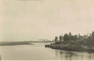
Postcard - ACC LOCK COLLECTION: B&W PHOTO OF A RIVER, EGYPT, POSTCARD, 1914-1918
Poastcard, WW1, B&W photo of one of the river Nile tributaries. Trees on the right side bank and palm trees in the distance beyond a small craft on the river. Handwritten in ink on the back - North of one of the tributaries of the Nile. Egypt Dec '15 Also handwritten in pencil - more of right side to appearpostcard, postcard, ww1, egypt, river nile -
Bendigo Historical Society Inc.
Booklet - Out & About around Bendigo
BHS CollectionBooklet of 95 pages. Red and yellow front covers with colour and B&W photos. Brief descriptions of townships around and north of Bendigo illustrated with B&W photos plus a map on page 5. Insert of sketch map of Kamarooka Forest and bird guide to forest. Edited by Jean and Ken Arnold. Published by Crown Castleton Publishers, Bendigo and printed by Centre State Printing, Maryborough, Victoria. 'M & J Qualtrough' sticker on title pagebendigo, townships -
Bendigo Historical Society Inc.
Booklet - Bendigo Goldfield, Geological Survey Report No 93
Soft cover booklet of 50 pages. Geological Survey Report No 93. Bendigo Goldfield. Spring Gully, Golden Square, Eaglehawk By C.E. Willman and H.E.Wilkinson. Colour photo of the North Deborah mine poppet-head on a pale-yellow front cover. Illustrated with B&W photos, maps and sketches. Published 1992 by the Department of Manufacturing and Industry Development , Victoria Errata page pasted inside front cover. M & J Qualtrough sticker on title page. bendigo goldfield, geological survey -
 Monbulk RSL Sub Branch
Book, Norman Bartlett, Australia at arms, 1955
An anthology of true life stories from many wars, told by Australians who served in New Zealand, the Sudan, South Arica, China, Mesopotamia, Gallipoli, Palestine, France, North Africa, Crete, Malaya and New Guinea.ill (plates) (b/w)non-fictionAn anthology of true life stories from many wars, told by Australians who served in New Zealand, the Sudan, South Arica, China, Mesopotamia, Gallipoli, Palestine, France, North Africa, Crete, Malaya and New Guinea.australia - military history, australia - military - personal narratives -
 Bendigo Historical Society Inc.
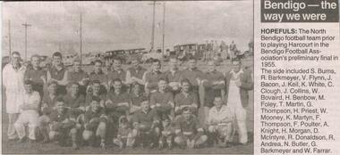
Newspaper - JENNY FOLEY COLLECTION: HOPEFULS
Bendigo Advertiser "The way we were" from Monday, October 25, 2004. Hopefuls: the North Bendigo football team prior to playing Harcourt in the Bendigo Football Association's preliminary final in 1955. The side included S. Burns, R. Barkmeyer, V. Flynn, J. Bacon, J. Keil, K. White, C. Clough, J. Collins, W. Bovaird, H. Benbow, M. Foley, T.Martin, G. Thompson, H. Priest. W. Mooney, K. Martyn, F. Thompson, F. Poulter, A. Knight, H. Morgan, D. McIntyre, R. Donaldson, R. Andrea, N. Butler, G. Barmeyer and W. Farrar.newspaper, bendigo advertiser, the way we were -
 Bendigo Historical Society Inc.
Document - LONG GULLY HISTORY GROUP COLLECTION: JOHN JEWELL
Five typed pages outlining the life of John Jewell from his birth in Cornwall to his marriages, immigration to Australia and his living in Ballarat, North Queensland and then to Bendigo where he worked at the Kentish Mine and was later the Manager. He also managed the Carlisle and Unity Batteries, was involved in a number of organisations and lent large sums of money to the Methodist Church in McIntyre Street Bendigo. There is a photo of John in his later life, one of his houses, John surrounded by 7 of his Grandchildren. and his headstone.bendigo, history, long gully history group, the long gully history group - john jewell, richard jewell, charity jewell (nee tippett), history of jewell family in cornwall, mrs frieda lee (nee jewell), sarah jewell, elizabeth tozer, john tippett jewell, henry tozer, nanny odgers, 'cadeueus', william john jewell, elizabeth jewell, john jewell, richard james jewell, kentish mine, george henry jewell, sarah ann clark, frederick albert victor jewell, william leslie norman jewell, mr j b watson, carlisle company, john jewell junior, carlisle battery, unity battery, the bendigonian 6/7/1909, long gully imperial football club, mining managers association, star of eaglehawk i.o.o.f., hopetoun band, carlisle mine cricket club , bell's reef co maldon, long gully fire brigade, dr simmonds, lanner, white hills cemetery, r bennetts, j cox, w arkinstall, w steen, g cox, t delchuray, mr a hicks mlc, mr w verece, messrs norris and son, passby mine, ah poo & co (workers of the sand), mr w farmer -
 Bendigo Historical Society Inc.
Document - LONG GULLY HISTORY GROUP COLLECTION: EAGLEHAWK & NOTED EVENTS
Notes on Eaglehawk compiled by H Biggs mentions early settlement, discovery of gold, separation of Eaglehawk from the Marong District Roads Board, Nominations for Council and Newspapers. Noted Events compiled by June Parry mention events from 1839 to 1876 and some in 1928. These included early settlement, gold discovery at The Rocks, Churches, hospital, Bendigo Advertiser, Theatre Royal, Police Office, Post Office, Census, First Council Works, Telegraph, Mining Company, Mining Board, Public Market, various buildings built, Rates, Schools, and very early trams.bendigo, history, long gully history group, the long gully history group - eaglehawk & noted events, h biggs, june parry, james mouat, joseph crook, marong district roads board, camp hotel, charles sherratt, mt alexander north run, grice and heape, ravenswood, gibson and fenton, mrs john kennedy, mrs patrick farrel, mr j a paton, mr lachlan mclachlan (bendigo mac), bendigo hospital, bendigo advertiser, theatre royal, lieutenant governor sir charles and lady hotham, harney's bridge, e j ennor, sandhurst fire brigade, mr townsend, bendigo water works, cornish & co, post office, bendigo pottery, bendiog agricultural society, benevolent asylum, bendigo gas company, cattle yards, coliban water supply scheme, cr w v simons, j mouat, sir henry barkly, sandhurst borough, eaglehawk borough, cr john mcintyre, duke of edinburgh, latham and watson's mine, galatea (model ship), st paul's church of england, rev g p despard, bendog rifle association, strathfieldsaye shire hall, corporate high school, bendigonian society, richard andrews, easter fair, g aspinall, j burnsides, viscount canterbury (sir h manners sutton), beehive stores, mining exchanges, annual waverley prize, bendigo water works, city fire brigade, city family hotel, bendigo united friendly society medical institute and dispensary, jewish synagogue, masonic hall, school of mines, j h abbott, australian natives association, temperance hall, royal princess theatre, albion hall, central state school, high school, gravel hill state school, early trams, electricity commission -
 Bendigo Historical Society Inc.
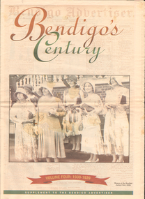
Newspaper - LONG GULLY HISTORY GROUP COLLECTION: BENDIGO'S CENTURY VOLUME FOUR: 1930 - 1939
Newspaper supplement titled Bendigo's Century Volume Four: 1930 - 1939. Front page is titled Bendigo's Century and has a photo of some women at the Bendigo Jockey Club, 1930s. Each year has heading of Who's Who, Weather, Sport and Business. First years are 1930 - 1939 titled A look back when. The page has photos of the Eaglehawk Cricket Club's first A Grade cricket premier ship team (1932 - 1933)., The monument to the late Bendigo mining magnate Ernst Mueller in Rosalind Park, The Bendigo Stock Exchange in the early 1930's - pictured are L L Dungey, T Williams, M P Kelly, C Mueller, E Hommoloff, R Kelly, T H Busst, T Hall, R Trembath, E A Woolcock, and C Burridge, the Carshalton mine in 1936 and The Edith and G V Lansell Laboratory at the Bendigo Hospital. 1930 - a photo of St Andrew's Church, the sundial outside the RSL Memorial Hall, The late Monsignor Rooney and The late John Douse Langley. The Ironbark Mine was the top gold producer. 1931 - Radio station goes on air, 1932 - Sir John dies, 1933 Bodyline men come to town, 1934 - Heroic rescues, 1935 - Hospital's new wing opened, 1936 - King mourned, 1937 - Beehive store towers above, 1938 - Mining shows mixed results and 1939 - Outbreak of war sobering.bendigo, history, long gully history group, the long gully history group - bendigo's century - volume four: 1930 - 1939, eaglehawk cricket club, ernst mueller, the bendigo stock exchangel l dungey, t williams, m p kelly, c mueller e hommoloff, r kelly, t h busst, t hall, r tremabath, e a woodcock, c burridge, charshalton mine, edith and g v lansell laboratory, st andrew's church, rsl memorial hall, mr gordon carter, sir john monash, state electricity commission, cr r watson, colonel gt v lansell, empire press congress, bendigo advertiser, mr e j hogan, eppalock weir, lyric theatre, bendigo red cross, mrs george mackay, st andrew's presbyterian church, mrs william hunter, right rev john douse langley, monsignor rooney, bendigo art gallery, the ironbark mine, coliban water, mr w wright, station 3bo, amalgamated wireless of australia ltd, advance bendigo group, the north league, st aidan's orphanage, bendigo freezing works, mr w wright, bendigo advertiser, mr w j stephens, advance bendigo group, north league, garden gully united gold mining company, bendigo football league, sir john quick, john quick snr, ironbark foundry, bendigo evening news, bendigo independent, bendigo advertiser, deakin governmnet, sir charles kingsford smith, southern cross, eppalock weir, bendigo art gallery, the hercules mine, gillies, aids & appliance shop, anne caudle centre, bill woodfull, harold larwood, dr john mccarthy, the hercules, douglas jardine, don bradman, sacred heart cathedral, joseph stapleton, john lynch, bert mcconchie, new red white and blue mine, royal humane society, william james, vernon shaw, south new moon mine, bendigo hospital, bendigo base hospital, duke of gloucester, rsl memorial hall, electricity commission, eaglehawk borough council, the plaza, backhaus estate, amalgamated freezing company, fortuna villa, mrs edith lansell, colonel lansell, the hercules mine, toni riley pharmacy, boardwalk, barkly hyett, the big blue consolidated company, the bendigo hospital, eaglehawk football team, kurmala wing of the bendigo base hospital, sir isaac isaacs, lyric theatre, sir john quick, hanro knitting mills, st luke's toddlers home, st aidan's orphanage, rsl memorial hall, lord and lady huntingfield, cr michelsen, bendigo art gallery, bendigo agricultural show, new blue mine, joseph stapleton, bendigo law association, bendigo hospital committee of management, bendigo rotary club, mr j mcrae, education department, andrew sunstan, sir stanley argyle, bendigo football league, north blue mining company, cr staples, king george v, king edward viii, cr j a michelsen, andrew mclay, bendigo advertiser, cohn bros, mrs wallis simpson, king george vi, capping mine shafts 1936, bendigo art gallery, madge freemen, william john leslie cross, judge wasley, the myer emporium, the baptist church, salvation army, ron masters, the central nell gwyn, sir john quick, leanne mcdonnell, windermere hotel, rev donald baker, john rumbold, central nell gwynne, the beehive building, the beehive store, james buick and co, thomas hope henderson, buick henderson & co, mr goodison, mr r o henderson, lt-col henderson, angus mackay, bendigo sewerage authority, mr s gordon moore, commercial bank of sydney, bendigo advertiser, edward alan morcom, polio, dr gardner kerr, the right rev conald baker, ridley theological college -
 Bendigo Historical Society Inc.
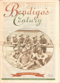
Newspaper - LONG GULLY HISTORY GROUP COLLECTION: BENDIGO'S CENTURY VOLUME FIVE: 1940 - 1949
Newspaper supplement titled Bendigo's Century Volume Five: 1940 - 1949. Each year has heading of Who's Who, Weather, Sport and Business. Front page is titled Bendigo's Century and has a photo of a group of soldiers in uniform and with rifles. They were district servicemen on leave in 1944. Each year has heading of Who's Who, Weather, Sport and Business. First years are 1940 - 1949 titled Bendigo as it was. It has two photos of women wading through the 1949 Pall Mall flood waters and one of Miners in the crib room of the Central Deborah Mine. They are Jackie Lewis, Bob Johnson, W Landy, Ryga Yates and Les Johnson. 1940 - Army moves in to racecourse, 1941 - Devastating fire at pottery, 1942 - Forces expand, 1943 - Nation's eyes on Bendigo, 1944 - News dawns of D-day landing, 1945 - City cheers the end of the war, 1946 - Celebrations begin in city, 1947 - Gallery gets top paintings, 1948 - Water plan looks good and 1949 - Flood takes a toll on city.bendigo, history, long gully history group, the long gully history group - bendigo's century - volume five: 1940 - 1949, bendigo advertiser, central deborah mine, jackie lewis, bob johnson, w landy, ryga yates, les johnson, central nell gwynne, department of defence, bendigo jockey club, 8th division, robert menzies, deborah mine, bendigo decentralisation vigilance committee, cr w h taylor, bendigo war funds organisation, the easter fair society, bendigo agricultural show committee, mr e g ham, mr j v fairbairn, cr a staples, the bendigo chamber of commerce, richard hartley smith abbott, captain harley abbott, bendigo art gallery, bill woodfull, bendigo high school, north deborah mine, boardwalk, toni riley pharmacy, windermere hotel, cr g a pethard, coliban system, north deborah mine, bendigo pottery, bendigo trades hall council, private lawrence burstall, major-general g j rankin mhr, andrew dunstan, ordnance factory, royal australian navy, hmas bendigo, sec offices, muioof, ymca, georger addlem, fred addlem, cr a j anderson, pauline buvhan thompson, leslie thompson, edward joseph leonski, bendigo football league, mr j dedman, william stephens, forest street methodist church, pte charles phillips, pte w e durward, pte t foley, william john stephens, central nell gwynne, air chief marshall sir arthur tedder, cr taylor, united nations, flying officer, r bruce tuff, flight lieutenant owens, royal air force, commonwealth war workers housing trust scheme, mr s mckinnon, bendigo decentralised vigilance committee, ravenswood estate, john lienhop mlc, margaret (peggy) brennan, strathfieldsaye shire council, school of mines, bendigo base hospital, william george ashman, ashman's tailors, bendigo jockey club, victorian football association, bendigo east swimming pool, deborah anticline, specimen hill methodist church, north deborah, adolf hitler, benito mussolini, australian 7th division, cr galvin, bendigo war funds organisation, hmas bendigo, lt-commander jackson, bendigo football league, central deborah mine, victoria day, cr truscott, bendigo gaol, lansellstowe, awas barracks, bendigo citizens committee, john cain snr, ordnance factory, bendigo agricultural society, the duke of gloucester, duchess of gloucester, bendigo tennis association, north deborah, gillies famous pies, aids & appliance shop, mrs georgina scott, dr j a neptune scott, alfred sisley, corot, daubigney, louis sonnenberg, gas employees' union, john lienhop, soldier settlement commission, burnewang estate, king george vi, princess elizabeth, lt philip mountbatten, mr e j w herbert, ansett airways, reg ansett, most rev, dr john mccarthy, dr bernard stewart, michael giudice, bendigo united breweries, bendigo lyric photo plays, bendigo sun newspaper, shamrock hotel, west bendigo progress association, alan mcdonald, south bendigo football club, albert collier, j t webbo, mervyn tresize, state rivers and water supply commission, eppalock reservoir, public works committee, bendigo rotary club, john edgar, bendigo base hospital, albert dunstan, benevolent home, magetti's wine hall, wallace reef wine hall, magetti family, albert magetti, lance galvin, bradford cotton spinnings (victoria) pty otd, arthur syer, stanley crossman, albert arthur dunstan, rev dr henry backhaus, city family hotel, lyric theatre, bank of australasia, city club hotelcolonial mutual building, r matchett & co, lansellstowe, leonard lansell, bendigo bas hospital, australian women's army service, mr hollway, kenworth (aust) ltd, foggitt jones's bacon factory, gordon sayers, sandhurst trustees, dr john drowley, alexander hislop, royal mint, north deborah mine, ironbark south mining company, central nell gwynne company, new chum syncline -
 Bendigo Historical Society Inc.
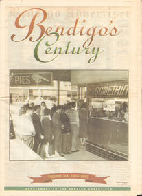
Newspaper - LONG GULLY HISTORY GROUP COLLECTION: BENDIGO'S CENTURY VOLUME SIX: 1950 - 1959
Newspaper supplement titled Bendigo's Century Volume six: 1950 - 1959. Front page has a photo of Gillies' famous corner, 1954. Each year has heading of Who's Who, Weather, Sport and Business. First year is 1950 titled Gillies: it's a Bendigo icon. 1951 is titled It's party time. 1952 - City mourns King George. 1953 - Mining ceases. 1954 - City thrilled at royal visit. 1955 - Push to save old Joss House. 1956 - Olympic fever grips Bendigo. 1957 - State Cabinet visits Bendigo. 1958 - Plan to keep historic mine. 1959 - Water storage woes solved. Back page has the Gillies Story.bendigo, history, long gully history group, the long gully history group - bendigo's century - volume six: 1950 - 1959, gillies' corner, bendigo advertiser, john lienhop mlc, north deborah mine, les gillies, alan gillies, norm gillies, black swan hotel, sir dallas brooks, cr a g weynton, bert mundy, cr poulston, the northern district school of nursing, lister house, the bendigo free library, rev dr c irving, shamrock hotel, sir albert dunstan, the most rev dr john mccarthy, jack davey, 1950 empire games, hercules gold mines, amy castles, ben templeton, cobb & co, cr norman oliver, reg parker, fred amer, les hammer, colonel george victor lansell, john quick, mr l w galvin, mr p j clarey mhr, hanro knitting mills, flooding, bendigo pottery, snow fall, the last lamp-lighter, the north deborah, aids & appliance shop, boardwalk, the late king george vi, the north deborah, beehive building, st paul's, st kilian's, upper reserve, bendigo trades hall, bendigo blackout, bendigo hospital, shamrock hotel, gerald smith, britannia hotel, mr a j harris, william morris (billy) hughes, andrew hampson, deborah anticline, north deborah, central deborah, diamond hill mine, north nell gynne mine, robert ross haverfield, sandhurst commercial courier, arthur moore lloyd, robert ross haverfield, angus mackay, jj casey, james henderson, david stuart, bendigo independent, colonel george lansell, bendigo base hospital, bendigo town hall, victorian electric traction association, the most rev b d stewart, st vincent's memorial college, commonwealth athletic club, south atlas racetrack, harp and shamrock hotel, mr and mrs f drake, cr f w clayton, cr r poulston, j h abbott & co, sir george lansell, clan macleod, bendigo gaol, queen alexandra fountain, belfast hotel, commonwealth bank, st vincent's college, lyric threatre, des duguid, brian cahill, lord's raceway, red white & blue extended gold mining company nl, central napoleon gold miningcompany nl, joss house, harry john, bendigo advertiser, mr leggatt, university of melbourne, anz bank, golden drive-in theatre, bank of australasia, john brown industries, bendigo football league, bendigo trotting club, faith leech, racv, bendigo sewereage authority, bendigo base hospital, bendigo benevolent asylum, henry bolte, jack davey, russell oakley, neville stilwell, channel seven, bendigo's olympic pool, annie caudle centre, strathfieldsaye aerodrome committee, southern airlines, cr d j osborn, cairn curran reservoir, state savings bank, commonwealth bank of australasia, belfast hotel, bennett's arcade, eppalock weir, bendigo cenotaph, sir edmund herring, cr a s craig, bendigo creche, bendigo high school, bendigo pottery, shamrock hotel, the venerable ronald richards, bishop riley, all saints cathedral, mr albert bush, bendigo arcade company ltd, woolworths, bull's head hotel, pike's corner, arcade hotel, upper coliban reservoir, cr tom flood, crystal egg co, sailor's guide, central deborah, central nell gwynne mine, bendigo benevolent home, ron masters, george daniel, eppalock dam, water commission, public works committee, bendigo central victoria telecasters ltd, channel nine, royal princess theatre, sir george lansell, volunteer defence corps, bendigo independent, countess erna cadorin, count ettore cadorin, ernst mueller, sutex pty ltd, dick turner, marco cavasassi -
 Bendigo Historical Society Inc.
Document - VICTORIA HILL - VICTORIA HILL, NEW CHUM LINE LEASES
Drawing of leases with lease numbers, names of owners and names of mines on the New Chum Line of Reef. Lease numbers are: L296, L1505, L5394, L7486, 130, L1286, L3941, L6299, L7427, L323, L3175, L812, L3757, L3888, L6198, L703, L1130, L703, L3321, L3347, L3884, L4167, L4357, L6296, L55, L239, L962, L1494, L1708, L239, L962, L3320, L4779, L6457, L129, L961, L3926, L5566, L19, L959, L4652, L4895, L5371, L7740, L960, L4415, L4793.document, gold, victoria hill, victoria hill, victoria hill new chum line leases, j wybrants, s h mcgowan, north old chum n l, c & t ballerstedt, ballerstedt & son, geo lansell, j holmes, victoria reef company, h hawkins, victoria reef quartz mining co n l, g n craig, j g wheadon, wells & gibbs, midway co, s g cole, gibbs ballerstedt & wells united mining co, w barker, humboldt g m co, great central victoria co n l, howard and neumann, endeavor qtz mining co, woodward & gibbs, endeavor co, smith horner white and tipping, albert co, h birch, victoria consols mining co, victoria reef, sullivan jackson, nicholas ballerstedt & jones, ironbark quartz mining co, j h abbott, ironbark co n l, h y north, new chum consolidated g m co, d macdougall, h von der heyde, hercules & energetic co n l -
Bendigo Historical Society Inc.
Document - VICTORIA HILL - THE DEEP MINES OF BENDIGO
Photocopied article titled 'The Deep Mines of Bendigo. Gold at 2, 070 feet'. From The Argus (Melbourne, Vic. : 1848 - 1954), Friday 16 march 1888, page 5. Article mentions gold being found at the greatest depth at which that metal has yet been obtained in Australia. Mentioned are the six deepest shafts in the Bendigo district. They are: Lansell's No 180, Victory and Pandora, Victoria Quartz, North Old Chum, New Chum Victoria and the Great Extended Hustler's. There was a deeper shaft at Stawell, the Magdala. Also mentioned are yields, amounts crushed, dividends paid and calls.document, gold, victoria hill, victoria hill, the deep mines of bendigo, the argus 16/3/1888, new chum and victoria, lansell's no 180, victory and pandora, victoria quartz, north old chum, new chum victoria, great extended hustler's, the magdala at stawell, mr w w barker, mr robert jackson