Showing 727 items
matching white major.
-
 Melbourne Legacy
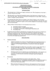
Document, Melbourne Legacy, Board of Management, Statement of Objectives and Policy Guidelines, December, 1989
Document notes the declining number of Legatees and increasing number of elderly widows. Importance of Widows Clubs. The provision of accommodation to elderly widows. Handicapped dependants. Funding of youth and educational activities. Expenditure control.Document recognises some major problems facing Legacy into the future and seeks to address these problems.White A4 paper x 4 pages of policy guidelines.Black type, notation in red biro top right hand corner, page one. Notation in blue biro, top left hand side, page four.objectives, policies -
 Melbourne Legacy
Letter, To Robert Bowring from Rob C. Allison, 2000
A file copy of a letter sent from Legatee Rob Allison to Robert Bowring (6th November 2000) in answer to a request regarding the origins of the first Dawn Service. Legatee Rob Allison signed himself as the Chairman, Advisory Tradition and History Committee. To research his response he consulted the AWM and summarised the content in the letter and enclosed four articles. Unfortunately the four articles sent to Robert Bowring are not included here. L/- Rob Allison makes reference to information obtained from Dr Richard Reid (historian at the Australian War Memorial and then the Commonwealth Branch of the Department of Veterans Affairs). Also Rob Allison makes reference to Lyn Witheridge (Australian War Memorial and later with the Centenary Federation Secretariat). He was addressing the rumour that there was a Dawn Service held in Albany WA in 1914 when the first convoy in WW1 from Australia was about to sail from Albany. The letter also makes reference to a gathering at Toowoomba QLD on Anzac morning 1919, however that rumour suggest that flowers were placed on returned soldiers graves, L/- Allison cast doubt about the placing of flowers on graves of returned service personnel, because only Major General Bridges and the Australian Unknown Soldier were the only two WW1 troops killed in action, to be returned to Australia.A record that members of the public approached Legacy with questions about military and post war history. Legatee Allison made an effort to research and base his reply on evidence.White paper with black type, a facsimile of a letterTelephone No 61395620309 top right.research, world war one -
 Melbourne Legacy
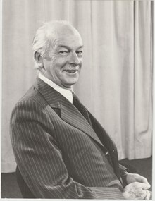
Document - Article, Legatee K D (Ken) Green, President 1981
A formal photo and a cutting from from a Melbourne Legacy President's report showing a photo of Legatee Ken Green (President of Melbourne Legacy in 1981). It was collected to be a record of a photo of past presidents. Legatee Ken Green served with the 15th Australian Field Company RAE 2nd AIF during World War 2. He continued with Citizen Military Forces after the war. He attained the rank of Major General with the 3rd Division between 1970-73. He joined Melbourne Legacy in 1959 on the nomination of Legatees Robert Myers and John Standish. The article was part of an album of past presidents from 1965 to 1989. The folder included biographical details and obituaries, eulogies and death notices of prominent Legatees. The items have been catalogued separately.A record of Legatee Ken Green a past president of Legacy. The information was collected to record the lives of prominent legatees in a folder.Black and white photo plus an article with a black and white photo of Legatee Ken Green - President 1981.past presidents, ken green -
 Melbourne Legacy
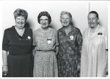
Photograph, Caulfield Widows Committee, 1991
Four Legacy widows from the Caulfield Legacy Widows Club.It was used in an issue of The Answer. From the name badges, they are (L to R): Shirley Cornish - Vice President, Mavis Major - Committee Member, Illegible - President, and Pauline Thompson - Secretary. It is believed that the date was 1991 due to the reference number from the photographic studio 911030B-28 means 3 October 1991, along with 00645, 00646, 00647, 00648, 00649, 00651. Photos of the committee members of different Widows clubs were taken by a professional photographer.Black and white photo of four Legacy widows and a proof sheet.Label on the back from Keesing Photographic with Reference No: 911030B-28. Pg 3 in and "Caulfied" in pencil.widows, widows club, committee -
 Melbourne Legacy
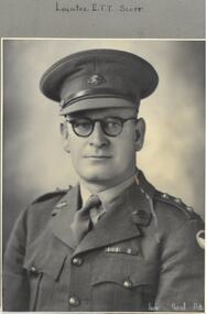
Photograph - Portrait, Legatee Edward Scott, 194
A portrait of a Legatee that had rejoined to serve in the second World War. The caption says it is Legatee E T T Scott. From NAA.gov.au Edward Thomas Tronson Scott joined on 6 March 1918 to serve in World War One, he was enroute on a troop ship when Armistice occurred and then ship returned to Australia. He caught influenza and was hospitalised for several months before being discharged. His records from the DVA show he enlisted 13 July 1940 and attained the rank of Major (service number VX46714), his posting at discharge was AASC Vic L of C Area. The portrait was in an album of photos taken in the 1940s (mostly 1945). Legatee E T T Scott died 30 September 1962.A record of a legatee enlisting to serve in the second World War.Black and white portrait of Legatee E T T Scott who re-enlisted in WW2. Part of a photo album with blue leather look back and front cover. From one of 20 pages with black and white photos.legatee, portrait, edward scott -
 Melbourne Legacy
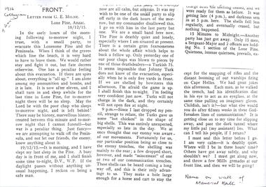
Document, Letter from GE Milne, Lone Pine ANZAC 18/12/1915, 1915
Black and white photocopy of a typed letter written by Company Sergeant Major (later Captain) George Eric Milne on the second last night at Lone Pine, Gallipoli. The letter to his parents show that he was scheduled to be in the second last party to leave the area during the evacuation. The other papers with this letter show that Legatee Don S (probably Simonson) had attended a planting of a Lone Pine seedling at Scotch College and the Head had read the letter out as part of the service. George Milne had attended school at Scotch College and is commemorated with his name on the wall of the Memorial Hall. From NAA his record shows that he had left Australia as part of the 24th Battalion (on the same ship as Legacy founder Stan Savige), he served at Gallipoli. Later with the 46th Battalion he was wounded in action and died in France on 5 April 1918, and is buried at Gezaincourt Communal Cemetery. Full text of the letter is transcribed and attached.A first hand account of the evacuation of Lone Pine from someone in the same battalion as Stan Savige.Black and white A4 photocopy x 5 pages of a typed letter written by GE Milne and associated research.gallipoli, world war one, george milne, evacuation -
 Bendigo Historical Society Inc.
Document - ABBOTT COLLECTION: TRADE CATALOGUE, 1937
John McIllwraith began the Melbourne Lead Works in 1854. After his death in Scotland in 1902, the business was continued by his sons, John, Thomas and David. In 1870 John became a member of the Melbourne Council and served as mayor in 1873/74. The business expanded to become a major supplier of plumbing supplies.Trade Price list for McIlwraith and Co 1937. Manufacturers and Merchants 48-56 Little Collins st Melbourne. It is a paper booklet covered in a steel blue light cardboard cover with 96 pages. It measures 18.5 x 24.2cm. Contains lists of products, photographs, maps and illustrations all in Black and white print. Printed by Osboldstone & Co Melbourne -
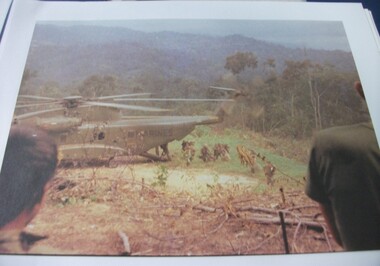
 National Vietnam Veterans Museum (NVVM)
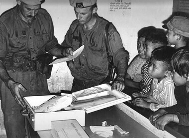
Photograph, Gibbons, Denis, Vietnamese Linguist
Denis Gibbons (1937 – 2011) Trained with the Australian Army, before travelling to Vietnam in January 1966, Denis stayed with the 1st Australian Task Force in Nui Dat working as a photographer. For almost five years Gibbons toured with nine Australian infantry battalions, posting compelling war images from within many combat zones before being flown out in late November 1970 after sustaining injuries. The images held within the National Vietnam Veterans Museum make up the Gibbons Collection. A black and white photograph of a digger 'Vietnamese Linguist' attached to 1st Australian Task Force, Nui Dat, Phuoc Tuy Province, studies NVA/VietCong documents captured during a battle in the Hat Dich area, a major NVA/VietCong infiltration route, South West of the Australian Task Force Basephotograph, vietnamese linguist, 1st atf base, nui dat, nva/vc, hat dich, gibbons collection catalogue, australian task force, documents, phuoc tuy province, nva/vietcong, denis gibbons -
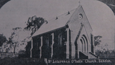 Ballarat Heritage Services
Photograph - Photograph - Colour, St Laurence O'Toole Catholic Church, Sandon
A small wooden school (22' x 14') was erected in Sandon by Father Patrick Smyth in 1859 (and at Golden Point) which was used for Mass and came to be regarded as a chapel. Twenty-three years later, a brick church was built by Father Allen at a cost of 1,000 pounds. The Church was blessed by Archbishop Goold on May 6th 1883 and dedicated to St Laurence. The 1940s saw some refurbishment and in 2002 a major restoration project was undertaken. St Laurence's was restored from roof to footings, by a dedicated band of volunteers and trades people. Work was completed mid 2003 and in November 2003 St Laurence's was re-dedicated with the celebration of Mass and a picnic tea. Black and white photograph of a brick church at Sandon, Victoria. sandon, sandon cemetery, st laurence o'toole catholic church, sandon -
 Federation University Historical Collection
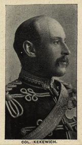
Photograph (black & White), Colonel Robert George Kekewich - South Africa
Kekewich commanded the 1st Battalion of the Royal Regiment (North Lancashire) in the Second Boer War. He commanded the garrison in Kimberley during the siege and successful defence of the town. At this time he came into conflict with Cecil Rhodes who persuaded John French, commanding the relief force, to replace Kekewich with another officer as commander of the garrison. Kekewich was promoted to colonel for his services. In 1901 he was wounded in an attack by General de la Rey near Moedwil but soon recuperated. Kekewich was in charge during the British victory at the Battle of Rooiwai, the last major battle during the war. He stayed in South Africa until peace had been signed and then returned to England. For his services he was appointed a Companion of the Order of the Bath and on retirement was appointed to the Honorary position of Colonel of the Buffs.Individual image taken from photographed poster of tobacco and cigarette cards.kekewich, 1st battalion, loyal regiment, second boer, kimberley, cecil rhodes, john french, garrison, de la rey, moedwil, rooiwai, companion of the order of the bath -
 Bendigo Military Museum
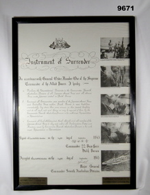
Document - FRAMED, WW2, 1945
Information title on document. "Instrument of Surrender" Signed by "Commander 22 Base Force/ Dutch Borneo Major General/ Commander Seventh Australian Division". Document - white coloured paper, copy of original document. Black ink print with five black and white photographs on right side Australian Coat of Arms at top of document. Frame - timber, black gloss paint, shaped moulding, glass front and timber backing with brown paper finish, metal clips and hanging wire. Two brass name plaques adhered to glass front lower left and lower right corners with information. Framers stamp on backing paper.Brass plaques - etched with black ink print. Left - "PRESENTED TO MITIAMO/ EAST LODDON RSL/ BY PM 6565 A.B. BRYAN O'BRIEN" Right - "THIS REMAINS TGHE PROPERTY OF THE MITIAMO/ EAST LODDON RSL". Framers stamp - Black ink "GALLERIA/ FRAMING & PRINTS/ Cnr HIGH 7 OAK STREETS/ GOLDEN SQUARE 3555/ Ph: (054) 47 0484. framed accessories, document, ww2, japanese surrender -
 National Vietnam Veterans Museum (NVVM)
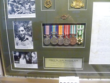
Memorabilia - Personal collection, framed
Framed mounted - Military Medal Keith Downward; Australian Active Service Medal with clasp Vietnam; Vietnam Medal; Australian Defence Medal; Australian National Service Medal; Vietnam Campaign Medal with clasp 1960. A certified True Copy of the citation for the Military Medal. Aluminium frame olive matt board, 6 medals and plaque. 1 infantry combat badge, 1 rising sun badge, 1 7RAR Corps badge, 3 black and white Photograph, Photograph 1 reads Pte Keith Downward receives the ribbon of the Military Medal from his Commanding Officer Major Jake O'Donnell at the 1st Australian Task Force Base (1ATF), Nui Dat, South Vietnam 25th February 1968. Photograph 2 reads Pte Keith Downward, the first Military Medal Winner from 7th battalion, The Royal Australian Regiment (7RAR), Nui Dat, South Vietnam 25th February 1968. Photograph 3 reads Major General R W Knights, General Officer Commanding (GOC), Southern Command congratulates Military Medal recipient Keith Downward 7RAR accompanied by his wife Ann, for single handedly capturing an enemy machine gun post. Captain Ernest G Crooks MBE looks on.3788618 Pte. Keith Downward M.M. / A Company 7 Battalion Royal Australian Regiment / the Military Medal was awarded for his actions during the battle of Suoi Chau Pha on 6th August 1967./ The training platoon of 7 RAR is named the Downward MM platoon in honour of Keith Downward7 rar, keith downward, military medal, battle of suoi chau pha, maj jake o'donnell, maj gen r w knights, capt ernest g crooks, a coy, downward -
 Trafalgar Holden Museum
Vehicle - VY Acclaim sedan, 2002
The front and rear of the body had minor restyling, with new front grille, headlights and taillights. The interior has been significantly upgraded. Interior upgrade includes a new instrument panel, centre console and steering wheel and new design transmission lever and handbrake.[2] There is also a new mobile phone power outlet under the centre console. The new instrument cluster features a large multi-function digital display (single or triple-window, depending on model), which displays information such as radio station display, PRND321 gear selected indicator, trip computer with stopwatch function, service reminders and a help facility. Standard features (on some models) now include "twilight sentinel" - automatic headlamp control, programmable headlamps off time delay, high feature Blaupunkt audio systems, road-speed sensitive intermittent wipers and passenger airbags. The VY Series II update added cruise control, front power windows variable front seat lumbar support, and revised interior trims. A 245 kW (329 hp) V8 was introduced to sports variants and a sportier repositioning of the Calais model. This repositioning included a subtle body kit, the option of a 235 kW V8 in place of the previous 225 kW (302 hp) and a firmer suspension tune (known as FE 1.5) that was not as stiff as the FE2 suspension on sports variants. Released in September 2002 and produced until August 2004 (with a Series II released in August 2003), the VY series was the first major design departure (both inside and out) of the third generation Commodore range released in August 1997. It launched at the same time as the Ford Falcon (BA).VY Holden 4 door sedan white paint with grey fabric upholsteryLion and stone emblem grille centre, V6 badge on mudguards, Commodore badge on boot LHS, Lion and stone badge on boot centre, Acclaim badge RHS of boot lidvehicle, commodore, car -
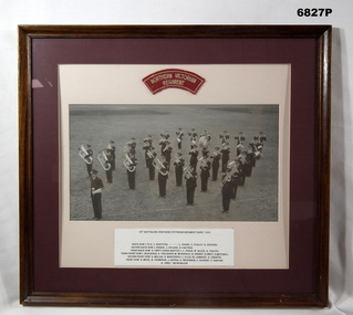 Bendigo Military Museum
Photograph - PHOTOGRAPH, FRAMED, 1955, c1956
Title and List of Band Members. "38th BATTALION, NORTHERN VICTORIAN REGIMENT BAND 1955" Back row L. to R.: J. GRIFFITHS, ........... ............, L. FRANK, E. STANLEY, K. HOCKING. Second back row: J. DORBIE, J. BOLAND, A. CARTER. Third back row: A. SWIFT (BAND MASTER), L. PHAIR, W. ALLEN, A. TRAYES. Third front row: I. DEAUROGH, R. TREVASKIS, M. McDONALD, A. BISHOP, R. SWIFT, R. MITCHELL. Second front row: N. MILLAR, N. MARCHINGO, L. ELLIS, M. LAMBERT, R. CHRISTIE. Front row: H. MEEK, A. THOMPSON, J. RIPPER, G. WILKINSON, F. GILBERT, V. GREGOR, K. JINKS - DRUM MAJOR"Photograph, black and white on paper, a group photograph of a Regimental Band on parade, standing on grass. Cloth insignia - red background with white embroidered lettering above photograph. List of band members - black ink type written on white card below photograph. Mount - double mounted, exterior dark red colour cardboard, inner cream colour cardboard. Frame - timber with brown varnish finish, glass front and cardboard backing.Cloth Insignia Lettering "NORTHERN VICTORIAN REGIMENT".passchendaele barracks trust, framed accessories, photograph, 38th battalion, regiment band -
 National Vietnam Veterans Museum (NVVM)
Photograph, Gibbons, Denis, Midwifery Replacement Kit
Denis Gibbons (1937 – 2011) Trained with the Australian Army, before travelling to Vietnam in January 1966, Denis stayed with the 1st Australian Task Force in Nui Dat working as a photographer. For almost five years Gibbons toured with nine Australian infantry battalions, posting compelling war images from within many combat zones before being flown out in late November 1970 after sustaining injuries. The images held within the National Vietnam Veterans Museum make up the Gibbons Collection. A black and white photograph of WO2 Brian Quee, the Squandron Sergeant Major, assisted by 2Lt Mike Meehan of 161 (Indep) Recce Flight, attempt to fathom the complexities of a Midwifery Replacement Kit watched by local village children during a Medcap at Xuyen Mocphotograph, wo2 brian quee, 2lt mike meehan, 161 recon flt, medical, xuyen moc, gibbons collection catalogue, vietnamese children, medcap, squadron sergeant major, midwifery kit, denis gibbons -
 National Vietnam Veterans Museum (NVVM)
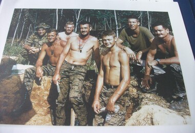
Photograph, Leadership group the day before the Battle of Ngok Tavak, 9/05/1968 12:00:00 AM
Captain John E D White, Australian Army Training Team in Vietnam (AATTV) took over command of 11 Mobile Strike Force (Mike Force) Company in Da Nang, Vietnam, in February 1968. He was 26 years old. The 2 NVA Division was moving from Laos into South Vietnam and his mission was to establish contact with the division and trace its movements south. In mid-March the company was air lifted to the Special Forces camp of Kham Duc, near the Laotian border. They used an old French Foreign Legion fort as a temporary base from which patrols could be sent out. White called it Ngok Tavak after a nearby mountain. Initially, patrols failed to find the enemy, but in late April a patrol clashed with the enemy. At the same time, White received intelligence that the NVA division was closing in. At night they could hear explosions in the distance heading toward them. White decided their best chance was to leave the fort and take to the jungle to adopt guerrilla tactics. However, in the meantime a platoon of United States Marine Corps artillery arrived bringing with them two howitzers and a stockpile of ammunition. To abandon the fort was to abandon the guns. White contacted Da Nang, explaining the predicament, and was ordered to remain where he was. A Civilian Irregular Defense Group (CIDG) platoon was sent to reinforce his numbers. This was a para military force comprised mainly of indigenous highlanders, trained by United States Special Forces. They also brought with them two mortars and their crews. At 3.15am on 10 May 1968 some members of the CIDG chose to assist the NVA to attack the fort instead of supporting Mike Force, and close hand to hand fighting followed, along with grenade attacks and heavy machine gun fire. Air support offered a brief respite from the NVA attack, and some NVA forces were pushed back outside the perimeter by counter attacks, but at 9am White contacted Da Nang to advise that his position was untenable. A second attack was imminent and they could not withstand it, so they would have to withdraw. The wounded were evacuated by helicopter (under orders from Major Mai, the NVA had not attacked the previous medical helicopters that collected the wounded under the cover of air strikes) and at 1pm the rest of the force evacuated east, into the jungle. The NVA did not notice their withdrawal, and continued mortar attacks on the fort for another ninety minutes. Seven kilometres from the fort White called for a helicopter withdrawal of his forces. The force was successfully lifted to Kham Duc and then Da Nang. (Credit AWM)Coloured image of 7 soldiers (5 shirtless) posed on the edge of a foxhole with jungle in background. L-R Willie Swicegood (USA), John White (AATTV-Aus), Ken Benway (USA), Frank Lucas (Aust), Clay Aitkins (USA), Glenn Miller (USA), Don Cameron (Aust)john white, aattv, battle of ngok tavak -
 National Vietnam Veterans Museum (NVVM)
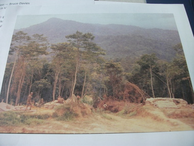
Photograph, Gateway to Ngok Tavak, 1/05/1968 12:00:00 AM
In May 1968, in the western jungle of Vietnam near Laos, led by Australian Captain J White, 11th Mobile Strike Force Company (MSF) occupied an old French fort on a hill named Ngok Tavak tasked with improving allied intelligence-gathering capabilities in the area. However, with enemy activity increasing, on May 4th, 44 US Marines, 35 CIDG (Civilian Irregular Defence Group) and two 105mm Howitzer field guns arrived as reinforcement from the Special Forces base at Kham Duc. By May 9th, Captain White’s company numbered about 200 men. Although in a good defensive position, coming towards them was the Iron Brigade of the 2nd Division of the North Vietnamese Army (NVA). At 03:00 on May 10th, the attack on Ngok Tavak began. The NVA, led by Major Dang Ngoc Mai, poured through the entrance at the eastern wall quickly occupying most of the fort. By midday the next day, Captain White had lost 40 Nung soldiers and 11 Marines with over 70 others badly wounded. Realising he could not withstand another attack, Captain White decided to abandon Ngok Tavak. Once the wounded were evacuated, Captain White ordered strike aircraft to blast a ‘corridor’ through the surrounding enemy cordon using napalm. By early afternoon, what remained of the defenders escaped through the ‘corridor’ and helicopters eventually flew them to Kham Duc. Colour image of edge of Ngok Tavak fort with soldiers sitting on & walking around sand-bagged foxholes. Jungle & mountains in background.battle of ngok tavak, john white -
 National Vietnam Veterans Museum (NVVM)
Photograph, Marines arrive at Ngok Tavak 04/05/1968
In May 1968, in the western jungle of Vietnam near Laos, led by Australian Captain J White, 11th Mobile Strike Force Company (MSF) occupied an old French fort on a hill named Ngok Tavak tasked with improving allied intelligence-gathering capabilities in the area. However, with enemy activity increasing, on May 4th, 44 US Marines, 35 CIDG (Civilian Irregular Defence Group) and two 105mm Howitzer field guns arrived as reinforcement from the Special Forces base at Kham Duc. By May 9th, Captain White’s company numbered about 200 men. Although in a good defensive position, coming towards them was the Iron Brigade of the 2nd Division of the North Vietnamese Army (NVA). At 03:00 on May 10th, the attack on Ngok Tavak began. The NVA, led by Major Dang Ngoc Mai, poured through the entrance at the eastern wall quickly occupying most of the fort. By midday the next day, Captain White had lost 40 Nung soldiers and 11 Marines with over 70 others badly wounded. Realising he could not withstand another attack, Captain White decided to abandon Ngok Tavak. Once the wounded were evacuated, Captain White ordered strike aircraft to blast a ‘corridor’ through the surrounding enemy cordon using napalm. By early afternoon, what remained of the defenders escaped through the ‘corridor’ and helicopters eventually flew them to Kham Duc. Colour image of U.S. soldiers disembarking from a helicopter in a clearing in the jungle. Foreground is rear of two soldiers watching. Background is mountains.united states - marine corps, battle of ngok tavak, john white, ngok tavak -
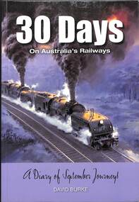 Victorian Railway History Library
Book, David Burke, 30 Days On Australia's Railways - A diary of September journeys, 2014
An entertaining look at railway events in Australia in the month of September - from 1848, when a meeting was called to start a railway company in New South Wales, to 2013, when the great Bayer-Garrett AD6029 steam engine was restored to working order. For some strange reason, September has been a month when particularly memorable railway events tend to occur. Author David Burke has crafted a 'diary' which documents, day by day, major happenings to do with railways in Australia - from the days of steam, to diesel, to diesel-electric and electrification, covering the first trains that ran between New South Wales and Queensland, and to Melbourne. It was in also September that the first sod was dug for the Trans-Australian Railway across the Nullarbor to Perth. The book is heavily illustrated with historic photographs, both black and white and colour, newspaper cuttings, sketches and maps, and features 13 paintings by renowned railway artist Phil Belbin. Names that leap to the fore among those who made railway history happen include Ben Chifley, the locomotive driver who became Prime Minister of Australia, engineer Dr John Bradfield, designer of the Sydney Harbour Bridge and responsible for putting Sydney's city trains underground, James Fraser, first Australian-born Chief Commissioner for Railways, and Harold Young, the Scotsman who designed the C38 engine and the Silver City Comet. Cover picture shows: Climbing the steep Fassifern Grade with a heavy coal train maakes for plenty of Bayer-Garrett action in Phil Belbin's painting of the AD60 class at work on the Shorty North line to Newcastle New South Wales Australia.ill. p.172.non-fictionAn entertaining look at railway events in Australia in the month of September - from 1848, when a meeting was called to start a railway company in New South Wales, to 2013, when the great Bayer-Garrett AD6029 steam engine was restored to working order. For some strange reason, September has been a month when particularly memorable railway events tend to occur. Author David Burke has crafted a 'diary' which documents, day by day, major happenings to do with railways in Australia - from the days of steam, to diesel, to diesel-electric and electrification, covering the first trains that ran between New South Wales and Queensland, and to Melbourne. It was in also September that the first sod was dug for the Trans-Australian Railway across the Nullarbor to Perth. The book is heavily illustrated with historic photographs, both black and white and colour, newspaper cuttings, sketches and maps, and features 13 paintings by renowned railway artist Phil Belbin. Names that leap to the fore among those who made railway history happen include Ben Chifley, the locomotive driver who became Prime Minister of Australia, engineer Dr John Bradfield, designer of the Sydney Harbour Bridge and responsible for putting Sydney's city trains underground, James Fraser, first Australian-born Chief Commissioner for Railways, and Harold Young, the Scotsman who designed the C38 engine and the Silver City Comet. Cover picture shows: Climbing the steep Fassifern Grade with a heavy coal train maakes for plenty of Bayer-Garrett action in Phil Belbin's painting of the AD60 class at work on the Shorty North line to Newcastle New South Wales Australia.railroads -- australia -- history., railroad travel -- australia -- history. -
 Bendigo Military Museum
Painting - SODIERS MEMORIAL INSTITUTE
The building is the Soldiers Memorial Institute Pall Mall Bendigo. The period of the painting is between the years 2008 and 2016 after the remodeling of the Forecourt and the major renovations to the building 2016 - 18. This is the first of 3 water colours by Stan Thomas. The building was the HQ of the Bendigo RSL now known as the Bendigo Military Museum. Refer Cat No's 8000.2, 8222, 8224 for the building history.Painting, water colour, timber gold frame, painting is set in two white insets, painting shows a large building greyish colour with a dome on top by artist Stan Thomas.Hand painted on, "RSL Hall Bendigo", "Stan Thomas"brsl, smirsl, painting, rsl hall -
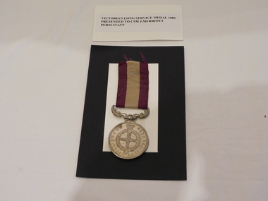 The 5th/6th Battalion Royal Victoria Regiment Historical Collection
Medal - Victorian Long Service Medal 1880 Presented to CSM J. Merriott Perm Staff
presented for long serviceSilver Medal mounted on a decorative arm. Ribbon is made up of two 9mm Violet Bars set astride a 14 mm off white bar Obverse face has a St. George Cross with 5 stars inside of a belt surmounted by a crown. This is surrounded by the words Local forces Victoria. The Reverse of the medal has " For long and efficient service" embossed on itJames Merriott COY. SERGT. MAJOR PERMT. STAFF5/6 rvr, 5/6 rvr officer's mess / sergeant's mess, victorian, colonial, medal, long service medal -
 Bendigo Historical Society Inc.
Book - STRAUCH COLLECTION: THE PENINSULA STORY BOOK 2
Victoria's first quarantine station was established at Hobson's Bay in 1840. However with the influx of immigrants during the gold rush, a new station was needed in Port Phillip Bay. In 1852 the "Ticonderago" arrived with 300 passengers ill with scarlet fever and typhus. They were landed at Point Nepean, Portsea, which which was known as the "Sanitary Station" until the 1880's when it's name changed to the Quarantine Station. It ceased quarantine duties in 1980.The Peninsula Story Book 2 Hell to Health the history of quarantine at Port Phillip Heads 1852 - 1966 by Major J.H.Welch, published by the Nepean Historical Society. Soft cover 96 pages with black and white photographs.Major J H Welchvictoria, history, quarantine station, australia-quarantine station-portsea vic-history-victoria -
 National Vietnam Veterans Museum (NVVM)
Photograph, Gibbons, Denis, Water Bottle Delivery
Denis Gibbons (1937 – 2011) Trained with the Australian Army, before travelling to Vietnam in January 1966, Denis stayed with the 1st Australian Task Force in Nui Dat working as a photographer. For almost five years Gibbons toured with nine Australian infantry battalions, posting compelling war images from within many combat zones before being flown out in late November 1970 after sustaining injuries. The images held within the National Vietnam Veterans Museum make up the Gibbons Collection. A black and white photograph of a 9 Sqn RAAF Huey delivers a cargo of sandbagged, freshly filled water bottles to a Fire Support Base for distribution to the infantry Diggers. Water was always a major problem for the Diggersphotograph, 9 sqn, raaf, huey helicopter, fire support base, digger, infantry, gibbons collection catalogue, denis gibbons -
 Ringwood and District Historical Society
Photograph, Major General Beavis and unknown lady attending a function in Ringwood. c1960
... Benares St., Mitcham'. Black mand white photograph Major General ...Black mand white photographWritten on back of photograph: "Major General Beavis, c1960." Back of photograph reads, 'John Gallagher, Photography, 4 Benares St., Mitcham'. -
 Bendigo Military Museum
Uniform - MESS DRESS, CGCF, 1960
.1) Black woollen jacket. Gold Sergeants stripes. Survey Regt collar badges. It has 4 brass buttons on front. 4 major pockets on front, the top two are held shut with brass buttons. .2) Trousers black. Red welt down side of legs - width 4 cm. Buttoned fly, black plastic buttons for braces. .3) Shirt - white, long sleeved with 7 pearl like buttons on front. It has a pocket on the left breast. .4) Belt - black wool, brass buckle. .5) Tie - black woollen. .6) Cap - Officers. Black leather peak. Survey regiment badge. Red band around hat..1) Jacket - "A. Skidmore" , “NR possibly 36894”post ww2, army, uniform, suurvey regiment, passchendaele barracks trust -
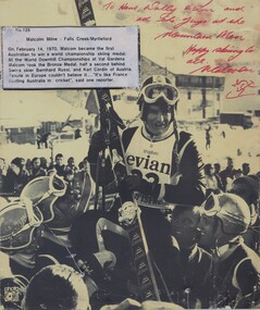 Falls Creek Historical Society
Photograph - Malcolm Milne wins Bronze Medal at World Downhill Championship 1970
This item is from the private collection of George Shirling of Red Onion, Falls Creek. It depicts Malcom Milne after winning the Bronze Medal at the FIS Alpine World Ski Championships at Val Gardena, Italy in 1970 becoming the first Australian skier to win a World Championship skiing medal. George Shirling arrived in Falls Creek in 1962. He engaged Phil Nowell to build the original Koki Alpine Lodge which opened in 1965 with 14 beds. George operated the lodge with Michael “Baldy” Blackwell as manager. He also graduated in sport psychology in 1981 and was invited to become team psychologist for the Australian Winter Olympic team which went to Albertville, France, in 1992. He later owned the Red Onion Chalet. George credited the success of Koki to “Baldy” Blackwell. “Baldy” and Phil Nowell started the Trackers Mountain Lodge in partnership during the 1980s. In 1971 George sold Koki Lodge to Sigi Doerr. In 2024 the renamed Koki Alpine resort remains a highly popular destination in Falls Creek. George Shirling passed away on 27th February 2023. He had remained actively involved in Falls Creek and was generous with his time and knowledge, always an amazing supporter of The Falls Creek Museum and Falls Creek Village.This item is significant because it depicts Australian champion skier Malcolm Milne winning his first major World Championship in 1970.A black and white photograph of Malcolm Milne taken at the World Downhill Championships in 1970. It has been autographed in red pen. An explanatory sign is attached.Written in red ink at top right: "To Hans, Wally & Lou and all the guys at the Mountain Man. Happy Skiing to all, Malcolm"george shirling, red onion, malcolm milne, falls creek -
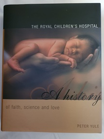 Alfred Hospital Nurses League - Nursing Archive
Book - Illustrated book, Peter Yule, The Royal Children's Hospital: a history of faith science and love, 1999
An insight into the origins and development of the Royal Children's Hospital, Melbourne. Opening in 1870 with six rooms as "the Melbourne Free Hospital for Sick Children, it has grown into a major paediatric institution. As well as the hospitals history, the book provides insisight into the soacial and economic conditions in Victoria in the late 19th and early 20th centuryIllustrated book with dust jacket. Book is bound in dark green material, with title authors name and publishers mark print ed in gilt on spine. Dust jacket is black and gold in colour, with a coloured photo of newborn baby lying on adult hand on front cover. Title and author's name on front cover, also on spine with the addition of the publisher's mark. On the back cover is the RCH coat of armsnon-fictionAn insight into the origins and development of the Royal Children's Hospital, Melbourne. Opening in 1870 with six rooms as "the Melbourne Free Hospital for Sick Children, it has grown into a major paediatric institution. As well as the hospitals history, the book provides insisight into the soacial and economic conditions in Victoria in the late 19th and early 20th centuryroyal children's hospital (melbourne), paediatrics-victoria-history -
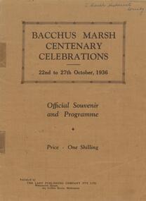 Bacchus Marsh & District Historical Society
Book, Bacchus Marsh centenary celebrations, 22nd to 27th October, 1936: Official souvenir and programme, 1936
A souvenir booklet produced in Bacchus Marsh to commemorate 100 years since the arrival of European colonists in the district Bacchus Marsh in 1836. It contains a brief history of European settlement in the area and a description of some of the major industries and infrastructure of the region. Also included are several black and white images of significant local buildings, parks, geographic features and a group portrait of shire councilors; Published by The Lady Publishing Company, Melbourne, 1936. Edited by F. C. McC Crisp; Online edition accessible from State Library of Victoria at: https://find.slv.vic.gov.au/permalink/61SLV_INST/1sev8ar/alma99837471360763628 pages. 25cm. BMDHS Location: AR/SU4non-fictionA souvenir booklet produced in Bacchus Marsh to commemorate 100 years since the arrival of European colonists in the district Bacchus Marsh in 1836. It contains a brief history of European settlement in the area and a description of some of the major industries and infrastructure of the region. Also included are several black and white images of significant local buildings, parks, geographic features and a group portrait of shire councilors; Published by The Lady Publishing Company, Melbourne, 1936. Edited by F. C. McC Crisp; Online edition accessible from State Library of Victoria at: https://find.slv.vic.gov.au/permalink/61SLV_INST/1sev8ar/alma998374713607636bacchus marsh history, centenaries bacchus marsh -
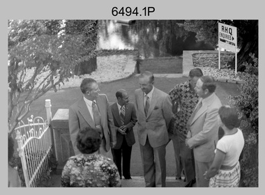 Bendigo Military Museum
Photograph - MAJGEN Nicholson - Director DMA to the Army Survey Regiment, Bendigo, 1980
This set of nine black and white photographs were taken during the visit to the Army Survey Regiment, Bendigo by the Director of the USA’s Defense Mapping Agency –MAJGEN William L. Nicholson III, on the 7th of February 1980. He was accompanied by US Army COL W.P. ‘Pinky' Holmes and an unidentified Major from the USAF. It is not known if their wives or partners were in attendance.This set of nine black and white photographs were taken during the visit to the Army Survey Regiment, Bendigo by the Director of the USA’s Defense Mapping Agency –MAJGEN William L. Nicholson III, on the 7th of February 1980. The photographs are on 35mm negative film and scanned at 96 dpi. They are part of the Army Survey Regiment’s Collection. .1) - Photo, black & white, 1980. L to R: unidentified civilian (facing away), MAJGEN William L. Nicholson III, MAJ Sam Schwartz US Exchange, CO LTCOL Bob Skitch, D-SVY COL NRJ Hillier, MAJ Don Swiney MBE, Mrs Glen Swiney. .2) - Photo, black & white, 1980. L to R: unidentified civilian & Mrs Glen Swiney, (facing away), MAJGEN William L. Nicholson III, CO LTCOL Bob Skitch, unidentified civilian (facing away). .3) - Photo, black & white, 1980. L to R: unidentified visiting USA officer, MAJ Sam Schwartz US Exchange. .4) - Photo, black & white, 1980. L to R: CAPT Peter Ralston, CAPT Dennis Puniard, CAPT Bob Roche, MAJGEN William L. Nicholson III, CO LTCOL Bob Skitch. .5) - Photo, black & white, 1980. L to R: unidentified (x4), MAJ Sam Schwartz US Exchange, unidentified, CAPT Bob Roche, unidentified (x3), MAJ Paddy Strunks, unidentified, Mrs Glen Swiney, unidentified civilian (facing away)., CAPT Don Maskew, unidentified civilian. .6) - Photo, black & white, 1980. L to R: MAJ Peter Eddy, D-SVY COL NRJ Hillier, CO LTCOL Bob Skitch, MAJGEN William L. Nicholson III, remainder unidentified. .7) - Photo, black & white, 1980. L to R: MAJGEN William L. Nicholson III, CO LTCOL Bob Skitch. .8) - Photo, black & white, 1980. L to R: ADJT CAPT John Harrison, unidentified civilian. .9) - Photo, black & white, 1980. L to R: Mrs Glen Swiney, unidentified civilians (x2).No personnel or civilians are identifiedroyal australian survey corps, rasvy, army survey regiment, army svy regt, fortuna, asr -
 Bendigo Military Museum
Photograph - RSM-Army Visit – Technical Tour, Army Survey Regiment Fortuna, Bendigo, 1989
This is a set of 16 photographs of a visit to the Army Survey Regiment, by the Regimental Sergeant-Major of the Australian Army (RSM-A) WO1 Kevin (Lofty) Wendt OAM, BEM on the 10th of August 1989. He was taken on a tour through the production areas and messes. RSM-A WO1 Kevin (Lofty) Wendt OAM, BEM was the 2nd RSM to be appointed to the position of RSM-A, the most senior Warrant Officer position in the Australian Army. His appointment was from 1987 to 1990. On this occasion he was escorted by WO1 Neville Stone, who was the RSM of the Army Survey Regiment from 1988 to 1990. Refer to item 6438.15P for photos of the SGT’s Mess function.This is a set of 16 photographs of a visit to the Army Survey Regiment, Fortuna, Bendigo by the Regimental Sergeant-Major of the Australian Army (RSM-A) WO1 Kevin (Lofty) Wendt OAM, BEM on the 10th of August 1989. The photographs are on 35mm negative film and were scanned at 96 dpi. They are part of the Army Survey Regiment’s Collection. .1) to .2) - Photo, black & white, 1989. Wild B8 plotting on the AUTOMAP 2 system, L to R: WO1 Russell ‘Rusty’ Williams, RSM-A WO1 Kevin (Lofty) Wendt OAM, BEM, SPR Stuart Bowd. .3) to .5) - Photo, black & white, 1989. RAAF Charting, L to R: SSGT Dennis Learmonth, RSM-A WO1 Kevin (Lofty) Wendt OAM, BEM. .6) - Photo, black & white, 1989. RAAF Charting, L to R: SSGT Dennis Learmonth, RSM-A WO1 Kevin (Lofty) Wendt OAM, BEM, unidentified visiting RSM, WO1 Stevo Hinic. .7) to .8) - Photo, black & white, 1989. Map data editing on AUTOMAP 2 system, L to R: SPR Charmian McKean, RSM-A WO1 Kevin (Lofty) Wendt OAM, BEM, WO1 Stevo Hinic. .9) - Photo, black & white, 1989. Map data editing on AUTOMAP 2 system, L to R: SGT Paul ‘Hutch’ Hunter, RSM-A WO1 Kevin (Lofty) Wendt OAM, BEM. .10) - Photo, black & white, 1989. Photo Troop L to R: RSM-A WO1 Kevin (Lofty) Wendt OAM, BEM, WO2 Rob Bogumil. .11) - Photo, black & white, 1989. Print Troop L to R: CPL Peter Swandale, RSM-A WO1 Kevin (Lofty) Wendt OAM, BEM. .12) - Photo, black & white, 1989. Print Troop L to R: RSM-A WO1 Kevin (Lofty) Wendt OAM, BEM, unidentified visiting RSM, CPL Peter Swandale. .13) - Photo, black & white, 1989. OR’s Mess Committee, Tavern L to R: RSM-A WO1 Kevin (Lofty) Wendt OAM, BEM, PMC CPL Brendon McKinless. .14) - Photo, black & white, 1989. OR’s Mess Committee, Tavern L to R: CPL Noel Brinsmead, CPL John Gilbert. .15) - Photo, black & white, 1989. OR’s Mess Committee, Tavern L to R: PMC CPL Brendon McKinless, RSM-A WO1 Kevin (Lofty) Wendt OAM, BEM, CPL Noel Brinsmead, CPL John Gilbert, CPL AM Verley. .16) - Photo, black & white, 1989. OR’s Mess Committee, Tavern L to R: RSM WO1 Neville Stone, PMC CPL Brendon McKinless, RSM-A WO1 Kevin (Lofty) Wendt OAM, BEM, CPL Noel Brinsmead, CPL John Gilbert, CPL AM Verley, CPL Dave Cook..1P to .16P – no annotationsroyal australian survey corps, rasvy, army survey regiment, army svy regt, fortuna, asr