Showing 199828 items matching "12-errard-street-south"
-
 Tatura Irrigation & Wartime Camps Museum
Photograph, Hogan Street Tatura at night
Photograph of Hogan Street, Tatura, east of railway crossing with street lighting.Black and white photograph of Hogan Street, Tatura at night.on back: Hogan Street, Tatura, east of railway stationhogan street, tatura -
 Glen Eira Historical Society
Album - Album page, Regent Street, Circa 1972
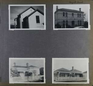
This photograph is part of the Caulfield Historical Album 1972. This album was created in approximately 1972 as part of a project by the Caulfield Historical Society to assist in identifying buildings worthy of preservation. The album is related to a Survey the Caulfield Historical Society developed in collaboration with the National Trust of Australia (Victoria) and Caulfield City Council to identify historic buildings within the City of Caulfield that warranted the protection of a National Trust Classification. Principal photographer thought to be Trevor Hart, member of Caulfield Historical Society. Most photographs were taken between 1966-1972 with a small number of photographs being older and from unknown sources. All photographs are black and white except where stated, with 386 photographs over 198 pages. At least 2 of these houses (17 and 84) are contributory properties to HO72 Elsternwick Estate and environs.Page 172 of Photograph Album with four photographs of differerent properties on Regent Street.Handwritten: Regent Street [top right] / 17 [under bottom left photo] / 84 [under bottom right photo] / 172 [bottom right]trevor hart, regent street, elsternwick, houses, mansions, cast iron work, verandahs -
 NMIT (Northern Melbourne Institute of TAFE)
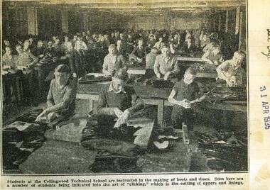
Exercise book: Newspaper cuttings from Exercise book of Newspaper cuttings from 15/8/1932 – 12/12/1935
Exercise book of newspaper cuttings from The Argus, The Age, The Sun and The Star from 15/8/1932 – 12/12/1935. Includes photo and article about the Boot and Shoe Course and studetns of Collingwood Technical School from The Age 31 April 1935.collingwood technical school, newspaper cuttings, boot and shoe students 1935, students, nmit -
 Ballarat Heritage Services
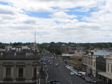
Photograph - Photograph - Colour, Ballarat From the Regent Cinema, Lydiard Street North, Ballarat, 2015, 27/12/2016
Lydiard Street is known as an axcellent example of Victorian architecture.Various views of Ballarat's Lydiard Street Northballarat, lydiard street north, buildings, aerial, birds eye, sebastions, regent cinema -
 Stawell Historical Society Inc
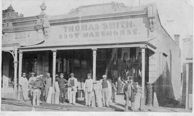
Photograph, Thomas Smith Boot Warehouse Upper Main Street South Side
Out of 1880's photograph Album Business on bend of Upper Main Street about opposite Allingham Drapers Man second from left has arm in a sling.Shopfront with ten men in front all in hats . Carpet roll visible on right beside steep lanewayThomas Smith Boot Warehousebusinesses -
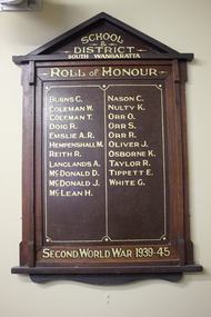 Wangaratta RSL Sub Branch
Memorabilia - Honour Board, South Wangaratta School and District, c1945
The original South Wangaratta Primary School served the district for over 110 years and closed in December 1985 before moving to new premises. When the school closed in 1989 and with the demise of the South Wangaratta Hall due to flooding in the 1990's the Honour Board was wrapped in a blanket and stored in a shed for the best part of 10 years before being donated to the Wangaratta RSL for safekeeping and permanent display. South Wangaratta School and District Honor Board lists names of students who served during WW2Timber Honour Board with two columns consisting of twenty one names in gold paint.School and District South Wangaratta. Roll of Honour. Second World War 1939-45world war 2, south wangaratta, honour board -
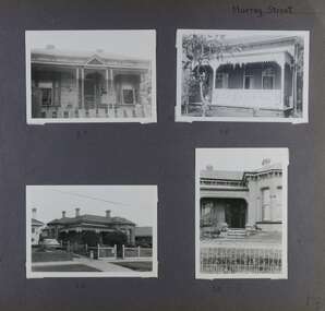 Glen Eira Historical Society
Album - Album page, Murray Street, Circa 1972
This photograph is part of the Caulfield Historical Album 1972. This album was created in approximately 1972 as part of a project by the Caulfield Historical Society to assist in identifying buildings worthy of preservation. The album is related to a Survey the Caulfield Historical Society developed in collaboration with the National Trust of Australia (Victoria) and Caulfield City Council to identify historic buildings within the City of Caulfield that warranted the protection of a National Trust Classification. Principal photographer thought to be Trevor Hart, member of Caulfield Historical Society. Most photographs were taken between 1966-1972 with a small number of photographs being older and from unknown sources. All photographs are black and white except where stated, with 386 photographs over 198 pages. Houses shown at 35, 58 and 32 Murray Street Elsternwick are still all extant (Google map image capture Dec 2018). Victorian Heritage Database - HO130 32 Murray Street Caulfield https://vhd.heritagecouncil.vic.gov.au/places/35535 (at 14/08/2021) No. 32 Murray Street is locally distinguished as the most imposing villa of its period in Murray Street whilst its association with J. W. Doyles, builder of several houses in the same street, is of interest. Its importance is enhanced by its substantially intact state.Page 138 of Photograph Album with four photographs (three landscape, one portrait) of 3 different houses on Murray Street. Handwritten: Murray Street [top right] / 35 [under top left photo] / 58 [under top right photo] / 32 [under bottom left photo] / 32 [under bottom right photo] / 138 [bottom right]trevor hart, garden, verandah, murray street, elsternwick, victorian style, houses, cast iron work, bay windows -
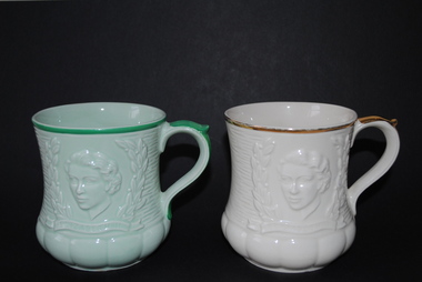 Anglesea and District Historical Society
Queen Elizabeth II Coronation Souvenir Mugs, 1953
Pair of Keele Street Pottery souvenir mugs of 1953 coronation of Queen Elizabeth 2. 1. One cream mug with gold trim. 2. One pale green mug with dark green trim.Marked "ENGLAND KSP" on base with "M" on base of cream mug.keele street pottery, coronation mug, queen elizabeth 2 -
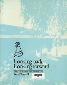 Narre Warren and District Family History Group
Book, Beryl Penwill, Looking Back looking Forward - The story of the "Berry Street" Child and Family Care, 1979
A history of the children who were abandoned and taken in by the Berry Street home. Many names of Nurse, matrons, Doctors and Directors are recorded60 p.; 27 cmnon-fictionA history of the children who were abandoned and taken in by the Berry Street home. Many names of Nurse, matrons, Doctors and Directors are recordedmothercraft nurses, lady bowen, tandarra, sister c. jack, joyce fletcher, victorian infant asylum and foundling hospital -
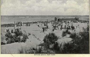 Port Fairy Historical Society Museum and Archives
Photograph, South Beach showing bathing boxes and playground, c.1918
Illustrates conditions at South Beach post WW1Black & white photographBathing Beach Port Fairybeach, sea, seascape -
Ithacan Historical Society
Administrative record, IPS Minute Book, 6 August 2001 to 12 November 2007
The minute book is a record of the activities of the Ithacan Philanthropic Society for six years from 6 August 2001 to 12 November 2007. The earlier entries have been handwritten while the later ones have been typed. The minute book which covered the years from 2001 to 2007 clearly indicate that although the members are of Ithacan descent their first language is English although many of the members have an understanding of Greek.The book is also a record of the social and philanthropic activities of Melbourne's Ithacan Community.A foolscap size bound ledger with tan suede binding on the spine and corners with a grey lotus border along the edges. The cover is red with a tan marbled pattern. Blue strippled pattern is around the pages on 3 sides. The red label on the spine has the words 'Collins Minutes 4394' printed in gold. Black stripes are across the spine. A white label has been stuck on the top left hand side of the cover. Written on the white label: IPS MINUTE BOOK/ FROM/ 6 AUGUST 2001/ UP TO AND INCLUDING / 12 NOVEMBER 2004.minute books, ithacan philanthropic society, ithaca, societies, greek community -
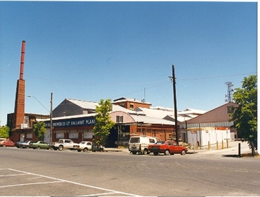 Federation University Historical Collection
Photograph - Colour, Ian Robinson (SMB Audio Visual), Former Ballarat Brewery, 1994, 16/12/1994
Colour photograph looking southwest along Lydiard Street South towards the Carlton and united Breweries, Ballarat Plant. ballarat school of mines, ballarat brewery chimney, carlton and united breweries, ballarat plant, chimney -
 Williamstown High School
1970 Home economics textbook, Approach to cookery. Rev. ed. South Melbourne: Macmillan Australia, 1969, 1969
'Approach to cookery' was the textbook used by Form 2 students during their Home Economics classes in 1970.Coloured soft cover book of 118 pages. Contains an introduction to cookery and recipes.Inside front cover: Janie Winter 2C W.H.S. Margaret Winter 128 D.R.H.Swilliamstown high school, 1970, home economics, approach to cookery, 1969, textbooks -
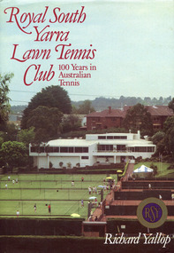 Surrey Hills Historical Society Collection
Book, Royal South Yarra Lawn Tennis Club: 100 Years in Australian Tennis, 1984
Royal South Yarra Lawn Tennis Club had its beginnings in the 1880s. The development of the club has been closely associated with the development of the game of tennis, with its changing styles of play. The Club has changed dramatically since its foundation in 1884. Tennis was a garden party pastime then and the clubhouse was a small wooden structure overlooking three asphalt courts. In the 1980s Royal South Yarra has been referred to as one of the best tennis clubs in the world. This history vividly recalls the early days of tennis and the tournaments and social events that enlivened the Club.xi, 148 p., [8] p. of col. plates : ill., facsims., ports. ; 27 cm.non-fictionRoyal South Yarra Lawn Tennis Club had its beginnings in the 1880s. The development of the club has been closely associated with the development of the game of tennis, with its changing styles of play. The Club has changed dramatically since its foundation in 1884. Tennis was a garden party pastime then and the clubhouse was a small wooden structure overlooking three asphalt courts. In the 1980s Royal South Yarra has been referred to as one of the best tennis clubs in the world. This history vividly recalls the early days of tennis and the tournaments and social events that enlivened the Club.royal south yarra lawn tennis club -- history, tennis clubs -- victoria -- south yarra -- history, richard yallop -
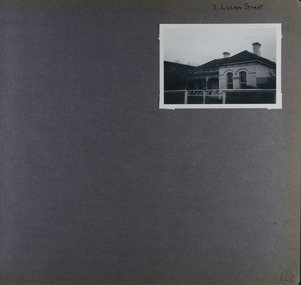 Glen Eira Historical Society
Album - Album page, Lucan Street, 7, Circa 1972
This photograph is part of the Caulfield Historical Album 1972. This album was created in approximately 1972 as part of a project by the Caulfield Historical Society to assist in identifying buildings worthy of preservation. The album is related to a Survey the Caulfield Historical Society developed in collaboration with the National Trust of Australia (Victoria) and Caulfield City Council to identify historic buildings within the City of Caulfield that warranted the protection of a National Trust Classification. Principal photographer thought to be Trevor Hart, member of Caulfield Historical Society. Most photographs were taken between 1966-1972 with a small number of photographs being older and from unknown sources. All photographs are black and white except where stated, with 386 photographs over 198 pages. Page 122 of Photograph Album with one landscape photograph of a house at 7 Lucan Street.Handwritten: 7 Lucan Street [top right] / 122 [bottom right]trevor hart, caulfield north, villa residence, verandah, terraces, timber roof brackets, gables, cast iron ridging, ornate plasterwork, arched windows, curved windows, chimneys, lucan street, victorian style, cast iron work, houses -
 Buninyong & District Historical Society
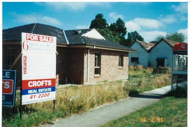
Photograph - Colour photograph of new building in Warrenheip Street, New building in Warrenheip Street 1996
Several new buildings being built replacing old cottage in Warrenheip Street altering the old streetscape.This image illustrates late twentieth century development of the the old streetscape of Buninyong replacing one cottage on a typical housing block with multiple townhouses. A colour photograph of new building replacing cottage in Warrenheip Street Buninyong February 1996Warrenheip Street, Buninyongstreetscape, warrenheip street -
 Marysville & District Historical Society
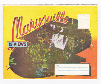
Postcard (item) - Colour photographs, Murray Views, Marysville 12 Views, 1950's
A fold out postcard of 12 colour photographs of scenes and landscapes in and around Marysville in Victoria.A fold out postcard 12 colour photographs of scenes and landscapes in and around Marysville in Victoria. These photographs were produced by Murray Views in Gympie, Queensland as a souvenir of Marysville.Marysville/ 12 VIEWS PRODUCED BY MURRAY VIEWS./ GYMPIE./ Q COPYRIGHT SAMUEL LEE & CO., PRINTERS. STEAVENSON'S FALLS, MARYSVILLE, VIC. TOURISTS AT MARYSVILLE, VIC. "FRUIT SALAD FARM", MARYSVILLE MAIN STREET, MARYSVILLE, VIC. ROAD SCENE, MARYSVILLE, VIC. THE CROSSWAYS, MARYSVILLE, VIC ROAD TO CUMBERLAND VALLEY, MARYSVILLE PANORAMA FROM BLACK SPUR, MARYSVILLE ROAD, MARYSVILLE, VIC. NICHOLL'S LOOKOUT, MARYSVILLE, VIC. TREE FERNS, MARYSVILLE, VIC. THE BRIDGE, MARYSVILLE, VIC.steavenson falls (image 1), tourists in marysville (image 2), taggerty river (image 3), fruit salad farm (image 4), main street marysville (image 5), road scene marysville (image 6), the crossways (image 7), cumberland valley (image 8), black spur (image 9), nicholl's lookout (image 10), tree ferns (image 11), bridge (image 12), marysville, victoria, postcard, souvenir, murray views -
Tatura Irrigation & Wartime Camps Museum
Photograph - copy, D. Clark, Early Hogan Street, 1989 copy
Copy of post card. Hogan Street, Tatura. Looking west. Williams store on right. Bell tower, fire station on left.Black and white copy of photograph of early Hogan Street, Tatura.on back: Hogan Street Taturahogan street tatura -
 Robin Boyd Foundation
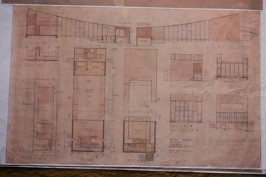
Drawing - Architectural, Robin Boyd, 290 Walsh Street, South Yarra, 14-Jan-58
This reproduction of the 1958 architectural drawings for 290 Walsh Street gives insight into Boyd's design. The finished building differs from these plans in some interesting ways - for example, the upstairs balcony cantilevers twice as far as originally drawn.Working Drawing, Colour copy, Paper type A1 -
 Melbourne Tram Museum
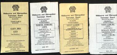
Ephemera - Timetable, Melbourne & Metropolitan Tramways Board (MMTB), MMTB Tram timetables, set of 12, 1971
Timetables for specific routes, day of week giving information on tram times at specific time points, route map, sections and fares and organisation address - 616 Little Collins St. Melbourne. 1 - Glen Iris - City route 6 - Oct. 1971 2 - North Coburg with connecting bus to Fawkner and Gowrie - Upfield on Sundays - June 1971 3 - Mont Albert - City - routes 42, 44, 45, 37 - Oct. 1971 4 - West Coburg - Domain Road and West Coburg City on Sundays - routes 55, 56 and 68 - May 1971 5 - Essendon Aerodrome - City route 59 - June 1971 6 - East Brighton - City - routes 64, 65, 62, 61 - Oct. 1971 7 - Carnegie - City - routes 67, route 66 - Oct. 1971 8 - Wattle Park - City route 70, route 71 and route 76 - Oct. 1971 9 - Camberwell - City - route 72, route 73 - Oct. 1971 10 - Prahran - City, North Richmond -Prahran - St Kilda Beach, routes 77, 78 and 79 - Oct. 1971 11 - East Preston - City and East Brunswick - City - routes 88, 89, 90. 96 and 97 - Oct. 1971 12 - ditto for Sundays printed on green paper. 13 - Route 8, Toorak, Oct. 1971-*Yields information about 1971 MMTB timetables.Set of 12 1971 MMTB Tram timetables, folded sheets.trams, tramways, timetables, mont albert, route 42, route 6, route 19, upfield, route 44, route 45, route 37, route 55, route 56, route 68, route 59, route 64, route 65, route 62, route 61, route 67, route 66, route 70, route 71, route 76, route 72, route 73, route 77, route 78, route 79, route 88, route 90, route 96, route 97, route 8 -
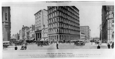 Melbourne Tram Museum
Photograph - Illustration, Collins Street and Queen Street Melbourne
Illustration titled - "Collins Street and Queen Street Melbourne" from the northwest corner looking east along Collins Street and then south along Queen Street, possibly around the time of the first world war. A policeman is on point duty. Shows some of the financial buildings that were located on this street. On one wall is written "Wallace Stockbrokers Reuters Office"Yields information about the Collins Street Melbourne financial district about the time of the first world war.Black and white print of a published Illustration - Collins Street and Queen Street Melbournecable trams, collins street, queen street, reuters -
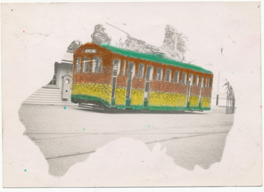 Ballarat Tramway Museum
Photograph - Digital image, L.W. Torr Best Street Bowen Hill and Brisbane Q, 4/03/1939 12:00:00 AM
Yields information about Ballarat tram 29 when it was dressed for the Floral Festival and the launch of the tram and how it was used by a small photograph publisher for sales.Digital image from the Wal Jack Ballarat Album of a postcard featuring the 1939 Floral Tram, photograph at the depot, rendered in colour and positioned within an outline of a map of Australia. Wal's notes date it as 4-3-1939. Uses the same base photo similar to 1369, but without the motor bike in the rear. On the rear has a the stamp "L.W. Torr Best Street Bowen Hill, Brisbane Q" See image i2 for rear of photograph. See Reg Item 7000 for a hand coloured image.Stamped on the rear of the photograph "L.W. Torr Best Street Bowen Hills, Brisbane Q" and the date stamp "5 May 1939"trams, tramways, floral tram, decorated trams, depot, tram 29 -
Federation University Historical Collection
Photograph - Black and White, Ballarat School of Mines
Photographic copy of the Ballarat SChool of Mines, Lydiard Street South, Ballarat.photograph, photographic copy, ballarat, ballarat school of mines, school of mines ballarat, lydiard street south -
 Bacchus Marsh & District Historical Society
Map, Gaynor Street Area Land Sales, Maddingley, 1888
This map was produced for a major sale of land in the Maddingley area of Bacchus Marsh in 1888. The sale was conducted by two firms from Melbourne, Carney and Kelly 12 Swanston Street Melbourne. and 'Richardson, Kerr & Co. 40 Flinders Lane Melbourne. 136 blocks were for sale.A single page paper map showing land allotments for sale in the Maddingley area of Bacchus Marsh. Locations shown include Gaynor Street, Maddingley Road South, Parwan Road, Mitchem Street, Typpynge Street, Finn Street and East Maddingley Road. . The map is pasted into a bound volume containing 76 maps or plans in total. High resolution digital image stored on BMDHS computer network. bacchus marsh victoria maps, maddingley victoria maps, land use, maddingley victoria history, land sales bacchus marsh, land sales maddingley -
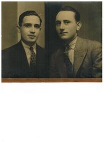 Ithacan Historical Society
Photograph, Orthon Moriatis South Africa, 20 July 1934
The photo is taken in Pretoria South Africa. One of the subjects is Orthon Moraitis.A sepia studio photograph of a head and shoulders portrait of two men dressed in suits. Written on the back and translated from the Greek: ORTHON MORIATIS/ PRETORIA S.AFRICA/ 20.7.1934.orthon moriatis, south africa -
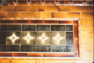 Whitehorse Historical Society Inc.
Photograph, South British Building, C1972
Coloured photo of tiles in South British Building, 19-25 Queen Street, Melbourne, built 1909. Demolished 1972south british building, australian tesselated tile co. pty. ltd. -
 Beechworth Honey Archive
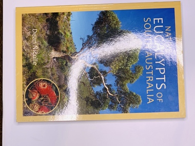
Publication, Native Eucalypts of South Australia (Dean Nicolle)Seedling paintings by Ian Roberts, 2013
Soft cover book slightly shorter than A4, Mustard colour cover with a photo of a eucalypt on the front cover, on the back cover is a blurb. On the inside front cover is a map of South Australia & on the inside back cover is a photo of the Author & a blurb about him -
 Kilmore Historical Society
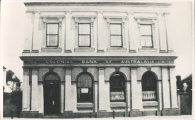
Photograph, 39 Sydney Street, Early 20th Century
21cm x 12.5cm building at 39 Sydney Street. The double story building has an ornate light-coloured facade. Arched windows on the ground floor and rectangle window with trim on the top floor. Signage on the building states "Colonial Bank of Australasia Limited"Written on the back: 396 12-86-17colonial bank, banks, banks and banking -
 Stawell Historical Society Inc
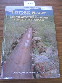
Book, Land Conservation Council, Historic Places Special Investigation South Western Victoria Proposed Recommendations, 1996
Historic Places Special Investigation South Western Victoria descriptive report Jan 1996Card cover with photo of a water metal water race with moutains in the background Historic places Special Investigation South-Western Victoria Descriptive report Land Conservation Councilstawell heritage -
 Whitehorse Historical Society Inc.
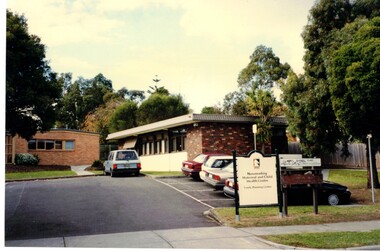
Photograph, Vermont South Maternal and Child Centre
The Vermont Maternal and Child Care Centre is situated in Karoboran Drive Vermont South.Coloured Photograph of a brick building with a council sign at the frontvermont south maternal and child centre, childrens services, maternal and child centres