Showing 643 items
matching 145
-
 Bendigo Historical Society Inc.
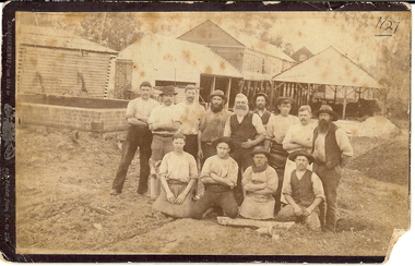
Photograph - EDINBURGH TANNERY: SHEEPWASH CREEK, 1890 approx
In 1878, J H Abbott bought the Edinburgh tannery from Mr Lambert and Mr Sibley in 1878 and set about expanding and modernising it. Soon it consisted of the necessary sheds surrounded by cottages built for the workers. The tannery buidings and processes consisted of :- 1. Hide shed that held 400-500 salted hides 2. Salt pots where the salted hides were soaked to remove all salt 3. Lime water pits where the hides were soaked to remove hair and all adherent flesh. 4.Beam shed where hides were hung so they could be scraped clean with double handled knives 5. Water baths that soaked the hides to remove the lime 6. Tan yard where there were 10 pits containing tanning liquid made from ground wattle bark. The entire process could take up to 9 months depending on the type of leather required. A forward thinking initiative of this tannery was the lack of waste. The left over flesh was boiled down to make tallow, trimmings from the hides was used to make glue, hair was washed and used by saddlers and upholsterers and the lime was mixed with tanning liquid to produce fertilizer. The tannery was producing about 240 sides of leather a week, with about two thirds of this being sent to England where it was in great demand because of its quality. In December 1894 the plant was destroyed by a fire believed to have started in the engine room. The plant was quickly rebuilt at an estimated cost of ten thousand pounds. The plant at 145 Tannery Lane operated until 1906.Sepia photograph: 13 workmen, shed at rear. Brick, timber, corrugated iron buildings in back ground. Interesting industrial site of the time. Photo of workmen taken in front of open sheds. Brick chimney and pile on L.H.S. Suggests Edinburgh Tannery, Sheepwash. J.H Abbott & Co. On back on small piece of paper 1127 Bgo. New registration No. rather indistinct. James Lerk 26.11.1999, ' Edinburgh Tannery - Sheepwash?' Ken Arnold Book 'Bendigo A History in Bottles & Stoneware 1852-1930 p10. This photograph labelled 'Workers at Sheepwash Tannery,' C. 1880-1890 with section about J.H. Abbott & Co. See book 'Bendigo A History in Bottles & Stoneware 1852-1930 by Ken Arnold, p.10RHSV 1127, Bgoorganization, business, edinburgh tannery, sheepwash creek. -
 Melbourne Tram Museum
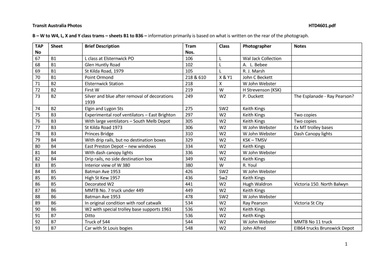
Album - Photo Album, Transit Australia Publishing, "TAP - Part B - W to W4, L, X and Y class trams – sheets B1 to B36", 1950's to 1990's
Photo Album - titled "TAP - Part B - W to W4, L, X and Y class trams – sheets B1 to B36", from Transit Australia Publishing. Photos used in the Destination City and other publications series. For a detailed list of photographs see htd4601i.pdf. For individual photo images see: \dbtext\hawthtramcoll\photo collections\htd4601-TAP-ParB, images TAP67 to TAP160. TAP67_106_ElsternwickPO_WalJack.jpg TAP68_102_GlenhuntlyRd_ALBebeek.jpg TAP69_105_StKildaRd_Jun1979_RayMarsh.jpg TAP70_218-610_PointOrmond_JohnBeckett.jpg TAP71_218_ElsternwickStation_25Sep1953_WJohnWebster.jpg TAP72_219_Dec1923_JohnStevenson_KSKcollection.jpg TAP73_249_Esplanade_decorations-gone_1939_PWDuckett.jpg TAP74_275_ElginSt_24Mar1956_KeithKings.jpg TAP75_297_EastBrighton_14May1961_KeithKings.jpg TAP76_305_SouthMelbourne_14May1961_KeithKings.jpg TAP77_306_StKildaRd_25Sep1953_WJohnWebster.jpg TAP78_310_PrincesBridge_WJohnWebster.jpg TAP79_329_GlenhuntlyDepot_Jul1929.jpg TAP80_334_EastPrestonDepot_7April1969_KeithKings.jpg TAP81_3326_ColinsSt_WJohnWebster.jpg TAP82_348_BalaclavaJunction_13Jan1962_KeithKings.jpg TAP83_380-dropcentreSeats_RYoul.jpg TAP84_426_BatmanAve_23Sep1953_WJohnWebster.jpg TAP85_436_HighSt-at-BennettsRd_16Feb1957_KeithKings.jpg TAP86_441_Victoria150_NorthBalwyn.jpg TAP87_No7-truck_449_KIngsway_KeithKings_9Sep1961n.jpg TAP88_478_BatmanAve_23Sep1953_WJohnWebster.jpg TAP89_534_VictoriaSt_RayPearson.jpg TAP90_536_HighSt_Kew_KeithKings_28Sep1961.jpg TAP91_536_HighSt_Kew_KeithKings_28Sep1961.jpg TAP92_No7-truck_544_WJohnWebster_29Sep1953.jpg TAP93_548_StLouis.EIB64.Trucks_BrunswickDepot_JohnAlfred_28Jan1957.jpg TAP94_548_StLouis.EIB64.Trucks_StKildaRd_KeithKings_19Mar1955.jpg TAP95_573_PointOrmond_LindsayCrow.jpg TAP96_574_CollinsSt_WJohnWebster_28Sep1953.jpg TAP97_646-113_1987_Bundoora.jpg TAP98_654_RoyalPde_BobLilburn_1949.jpg TAP99_658_ElizabethSt_WJohnWebster_28Sep1953.jpg TAP100_665_CollinsSt_WJohnWebster_28Sep1953.jpg TAP101_665_MacarthurSt_WJohnWebster_28Sep1953.jpg TAP102_459_BallaratRd_Footscray_ALBebee.jpg TAP103_459_BallaratRd_Footscray_ALBebee.jpg TAP104_460_NicholsonSt-into-BuckleySt_Footscray_WJohnWebster_28Sep1953.jpg TAP105_467_GordonSt.jpg TAP106_X1_WilliamstownRd.jpg T AP107_X1_interior.jpg TAP108_678_WilliamstownRd_KeithKings_13Jan1962.jpg TAP109_679_BuckleySt-depot.jpg TAP110_680_FootscrayStation_RayPearson.jpg TAP111_469_BatmanAve_25Sep1953_WJohnWebster.jpg TAP112_469_CamberwellDepot_KeithKings_25April1950.jpg TAP113_469_RiversdaleRd_NedMackintosh_1972.jpg TAP114_610_PointOrmond_JohnBeckett.jpg TAP115_611_CamberwellDepot_BobLilburn.jpg TAP116_613_BatmanAve_WJohnWebster_23Sep1953.jpg TAP117_104_JohnBeckett.jpg TAP118_105_MMTB.jpg TAP119_103-1024_StKildaRd_6Jan1973_AndrewFoy.jpg TAP120_106_GlenhuntlyRd.jpg TAP121_217_MalvernDepot_MMTB.jpg TAP122_217_MalvernDepot_DaveMacartney_12Sep1971.jpg TAP123_218_PointOrmond_LCrow.jpg TAP124_218_Elsternwick_WJohnWebster_c1953.jpg TAP125_218_GlenhuntlyRd_Broadway.jpg TAP126_W-body_MMTB.jpg TAP127_275_MalvernDepot.jpg TAP128_275_SwanstonSt.jpg TAP129_280_StKilda_WJohnWebster_c1953.jpg TAP130_308_KewDepot_c1925_MMTBAnnualReport.jpg TAP131_310-681_BatmanAve_RayPearson_1930s.jpg TAP132_317_Traverser_Preston_MMTB.jpg TAP133_340_HighSt_MMTB.jpg TAP134_364_Preston_MMTB.jpg TAP135_390_WellingtonPde.jpg TAP136_422_SwanstonSt_WJohnWebster_c1953.jpg TAP137_426_BatmanAve_LCrow.jpg TAP138_426_BatmanAve_WJohnWebster.jpg TAP139_426_CamberwellDepot_GeoffGrant_7May1955.jpg TAP140_436_SpencerSt_BobLilburn_1948.jpg TAP141_511_CamberwellDepot_GeoffGrant_7May1955.jpg TAP142_514_StKildaRd_WJohnWebster.jpg TAP143_544_StKilda_WJohnWebster.jpg TAP144_568_Decorated_RayPearson.jpg TAP145_660_GlenhuntlyDepot_LCrow.jpg TAP146_658_SwanstonSt_PaulNicholson_23Dec1967.jpg TAP145 - copy of TAP 145 TAP148_665_MacarthurSt_WJohnWebster_28Sep1953.jpg TAP149_671_Preston_MMTB.jpg TAP150_673_decorated_Preston_MMTB.jpg TAP151_674_PeelSt_DaleBudd_1965.jpg TAP152_674_WJohnWebster_c1953.jpg TAP153_456_PointOrmond_WJohnWebster_c1953.jpg TAP154_679_BuckleySt_LCrow_mid1950s.jpg TAP155_610_MorelandRd_PaulNicholson_22Sep1968.jpg TAP156_610_Preston_MMTB_1930.jpg TAP157_611_Preston_MMTB.jpg TAP158_613_BatmanAve_25Sep1953_WJohnWebster.jpg TAP159_419_Preston_MMTB.jpg TAP160_510_WellingtonPde_PTC_1989.jpgtrams, tramways, transit australia, destination city, tramcars, depots, w class, w1 class, w2 class, w3 class, w4 class, l class, x class, y class, tram 106, tram 102, tram 105, tram 218, tram 610, tram 219, tram 249, tram 275, tram 297, tram 305, tram 306, tram 210, tram 334, tram 336, tram 349, tram 380, tram 426, tram 436, tram 441, tram 449, tram 478, tram 534, tram 536, tram 544, tram 548, tram 573, tram 574, tram 646, tram 658, tram 665, tram 459, tram 460, tram 467, tram 678, tram 679, tram 680, tram 469, tram 610, tram 611, tram 613, tram 104, tram 1024, tram 217, tram 218, tram 280, tram 308, tram 210, tram 681, tram 317, tram 340, tram 364, tram 390, tram 422, tram 426, tram 436, tram 511, tram 514, tram 544, tram 568, tram 660, tram 658, tram 660, tram 665, tram 671, tram 673, tram 674, tram 459, tram 679, tram 610, tram 611, tram 613, tram 419, tram 510 -
 Bendigo Military Museum
Photograph - Print Troop Equipment, Lithographic Squadron – Army Survey Regiment, Fortuna, Bendigo, c1990s
This is a set of 25 photograph of Print Troop Equipment in Lithographic Squadron, Army Survey Regiment at Fortuna, Bendigo, 1990. Photo .1P features the new Howson Algraphy Autoneg printing plate processor. It improved quality control and efficiency and allowed the conversion of printing plates for positive or negative use. The Heidelberg Speedmaster 102 shown in photos .2P to .4P was a computer-controlled five colour lithographic offset printing press. It provided the Royal Australian Survey Corps a vastly improved printing capability, as the five colours for a standard topographic map was printed in a single pass. The print room housing the Speedmaster printing press was named Wayzgoose Hall after a medieval printing house festival. Wayzgoose Hall and the Speedmaster printing capability was commissioned by the Commander of the 3rd Military District BRIG P. Davies AM, ADC on Wednesday 27th June 1990. This occasion is covered in more detail in page 145 of Valerie Lovejoy’s book 'Mapmakers of Fortuna – A history of the Army Survey Regiment’ ISBN: 0-646-42120-4. For additional photos, refer to item 6062.4P for more photos of the Heidelberg Speedmaster printing press. The Print Room’s Map Assessment and Colour Evaluation Stations in photos .5P to .12P provided the Printer Technician suitable viewing environments to perform quality assessments of map samples. See item 6151.34P for more information and photos of technicians using the equipment. The Print Room’s Map Handling Station in photo .15P to .20P provided ergonomic benefits to the Printer Technician and improved despatching productivity. See Item 6070.9P for more information and photos. The Wohlenberg MCS-2 guillotine seen in photos .21P & .22P was a heavy-duty guillotine integrated component of the Map Handling Station, to trim bulk printed map stock. See item 6069.6P for more information and photos of earlier types of guillotine equipment. This is a set of 25 photograph of Print Troop Equipment in Lithographic Squadron, Army Survey Regiment at Fortuna, Bendigo, 1990. The photographs are on 35mm colour slides and were scanned at 96 dpi. They are part of the Army Survey Regiment’s Collection. .1) - Photo, colour, c1990s, Howson Algraphy Autoneg printing plate processor .2) to .4) - Photo, colour, 1990. Heidelberg Speedmaster 102 computer-controlled five colour lithographic offset printing press .3) to .10) - Photo, colour, c1990s, Heidelberg Speedmaster CPC 1-04 control unit. .11) to .12) - Photo, colour, c1990s, Map Colour Evaluation Work Station. .13) to .14) - Photo, colour, c1990s, Linear printing plate registration punch. .15) to .20) - Photo, colour, c1990s, Print Room’s Map Handling Station. .21) to .22) - Photo, colour, c1990s, Wohlenberg MCS-2 guillotine. .23) - Photo, colour, c1990s, Print Room Power supply equipment. .24) to .25P - Photo, colour, c1990s, Print Room Crown Fork Lift..1P to .25P - There are no annotations stored with the 35mm slides.royal australian survey corps, rasvy, army survey regiment, army svy regt, fortuna, asr, printing, litho -
 Melbourne Tram Museum
Album - Robert Thomson Slide Collection, "April 1981 (RT291-314)"
Photo - see pdf file for further information. Number Brief Description RT291 April 1981 Comeng - Z class tramcar on trailer at Comeng factory RT292 April 1981 E Burwood Terminus - tram 145 - "City - Lonsdale St" - route 75 RT293 April 1981 Batman Ave - tram 728 - "Prahran" - route 77 RT294 April 1981 Carlisle St - tram 223 - "St Kilda Beach" - route 79 RT295 April 1981 Airport Terminus - tram 1005 - "City" - route 59 RT296 April 1981 St Kilda Rd Extn - tram 311 - "City" - route 67 RT297 April 1981 Swanston St - tram 1018 - "City" RT298 April 1981 Elizabeth St - tram 52 - "North Coburg" - route 9 RT299 April 1981 Collins St - tram 939 - "West Preston?" - route 10 RT300 April 1981 Camberwell Depot - tram V214 RT301 W2 with pantograph Preston W'Shops - tram 546 - "Special" RT302 April 1981 Preston W'Shops - tram 170 - "Special" - route 00 & tram 1041 - "Special" - route 987 RT303 April 1981 Tram Over Bridge - tram 1011 - "Sth Melb & St Kilda Beach" - route 10 RT304 April 1981 Bourke St - tram 155 - "City" - route 96 RT305 April 1981 Camberwell Depot - tram 140 - "Camberwell Depot" - route 00 & tram 141 - "City - Lonsdale St" - route 75 RT306 April 1981 Bourke Street - tram 162 - "East Preston" - route 88 RT307 April 1981 Collins Street - tram 848 - "Mont Albert" - route 42 RT308 April 1981 St Kilda Rd Extn - tram ? - "? Glenferrie Rd" - route ? RT309 April 1981 Spring Street - tram 164 - "East Brunswick" - route 96 RT310 April 1981 Bourke Street - tram 162 - "City" - route 88 RT311 April 1981 east Preston Ter - tram 125 - "City" - route 88 RT312 April 1981 Port Melb Stn - train at station RT313 April 1981 Park St St Kilda - tram 883 - "?" - route 10 RT314 April 1981 Collins Street - tram 1002 - "Northcote via St Georges Rd" - route 9 Demonstrates the work of Robert Thomson in photography, collection and/or production of slidesAssembled album in a black presentation folder of 24 colour slides, collected or produced by Robert Thomson. All photographs have been scanned and placed on the Museum's G drive. A list of all photographs with details has been compiled. melbourne, tramways, trams -
 Peterborough History Group
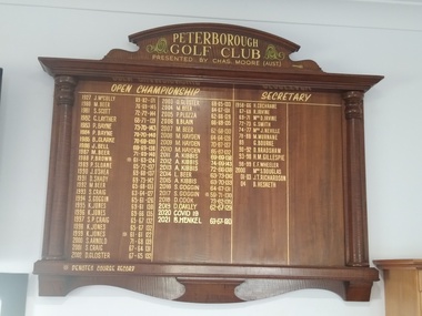
Memorabilia - Peterborough Golf Club Open Championship
The honour board records the names and scores of the Mens Open Championship winners and the name and dates of the Secretary. Chas Moore was the proprietor of Moore's Stores and a regular visitor to Peterborough, and donor of the Honour Board. The Mervyn Murnane Memorial Trophy also records the winners names. OPEN CHAMPIONSHIP 1927 J. McCully 89.82-171 2004 M. Beer 64.67-131 1980 M. Beer 76.69-145 2005 P. Plozza 62.66-128 1981 S. Scott 72.72-144 2006 B. Blain 66.69-135 1982 G. Layther 68.71-139 2007 M. Beer 62.68-130 1983 P. Bayne 73.70-143 2008 M. Hayden 64.64-128 1984 P. Bayne 70.70-140 2009 M. Hayden 70.67-137 1985 B. Clarke 70.69-139 2010 M. Hayden 65.67-132 1986 J. Bell 69.69-138 2011 A. Kibbis 69.69-138 1987 M. Beer 71.69-140 2012 A. Kibbis 74.69-138 1988 P. Brown * 61.63-124 2013 A. Kibbis 72.66-138 1989 P. Sloane 65.72-137 2014 L. Beer 63.73-136 1990 J. O’Shea 69.68-137 2015 A. Kibbis 63.70-133 1991 D. Shady 69.73-142 2016 S. Goggin 64.67-131 1992 M. Beer 65.68-133 2017 S. Goggin * 59.71-130 1993 S. Craig 63.64-127 2018 D. Cook 73.62-135 1994 S. Goggin 65-61-126 2019 D. Oakley 62.67-129 1995 K. Jones 69.61-130 2020 Covid 19 1996 K. Jones 69.66-135 2021 B. Henkel 63.67-130 1997 S.P. Craig 65.67-132 1998 K. Jones 65.67-132 1999 K. Jones * 61.61-122 * Denotes Course Record 2000 S. Arnold 71.68-139 2001 S. Craig 67.64-131 SECRETARY 1958 – 66 H. Cochrane 1967 – 68 R. Irvine 1969 – 71 Mrs, D, Irvine 1972 – 73 G. Smith 1974 – 77 Mrs. J. Neville 1978 – 88 M. Murnane 1989 G. Bourke 1990 – 92 D. Bradshaw 1993 – 98 H. M. Gillespie 1998 – 99 E. F. Wheeler 2000 Mrs. S. Douglas 2001 – 03 J. T. Richardson 2004 B. Hesketh Significant as it records the names and scores of the winners. It also has one odd record - 1927 J McCully, then skips to 1980. The story behind that is that a cup appeared at the Golf Club (its unknown where it came from) which was inscribed with 1927 J. McCully Peterborough Golf club Open Champion. It was probably not referring to this Peterborough but this club did not hold an Open Championship at that time, so it was decided that they would. The first Open championship was held in 1980 but the record from 1927 was included as it was impetus behind the decision to hold the Open Championship, which continues to this day. Polished timber honour board with upper lintel and doric columns on eihe side.Inscribed with the winners of the Open Championships from 1980 and the name of the Secretary from 1958. Also inscribed with: Presented by Chas. Moore (Aust)peterborough, golf, sporting honour boards, peterborough golf club -
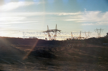 Eltham District Historical Society Inc
Photograph (Item) - Print, Sean Brady, Untitled (New Subdivision), 1988
Sean Brady 1988 Entrant No. 145 Ref: Series 34, Items 33, 34, 105, 106 SHIRE OF ELTHAM COMMUNITY PHOTOGRAPHIC SURVEY Photography is an artform which many of us practice, sometimes purely for artistic pursuit, sometimes to record the people and events in our lives. In 1988, as part of a local Bicentennial project, the Shire of Eltham conducted the Eltham Community Photographic Survey. Up to 100 entries were to be selected by a panel of photographers for entry into the Eltham Photographic Survey Exhibition. Entries had to be submitted by May 13, 1988. Entrants whose images were selected for the exhibition were contacted and requested to further submit an entry form providing entrant’s name, area of residence, age, and proposed captions. These details were then used to produce labels for the exhibition mounts. Where negatives had not been supplied, these were requested to support the display of printed enlargements mounted on 10” x 8” cardboard. The mounted prints were made available post exhibition for sale at $8.50 each for colour prints and $7.00 for B&W prints. Residents in the Shire were invited to collect a free roll of film and take a photograph of what they either liked or did not like about the area. A total of 160 entrants submitted multiple entries for the exhibition. Of those selected for exhibition, entrants ranged in age from 9 to 70 years. All custom colour and black and white printing for the exhibition was completed by Wattle Studios of Eltham. The Eltham Photographic Survey was jointly auspiced by the Shire of Eltham and Wattle Studios, of 953 Main Road, Eltham. The project was greatly assisted by: • David McRitchie, Media Studies Lecturer Victoria College, Rusden Campus. • Ian and Annette Toohill of Wattle Studios • Tracy Naughton, Eltham Community Arts Officer • Neville Emerson Pty. Ltd. • Superior Press, Eltham • Kodak Australasia Pty. Ltd. • Agfa Gevaert Ltd. • Townsend Colourtech Pty. Ltd. • The Australian Bicentennial Authority • Eleanor Bowers, Secretary, Eltham Arts Council The exhibition was placed on display in the Woolworths Arcade, Eltham between Monday June 6th and Saturday June 11, 1988. It was also intended to hold the exhibition at a venue in the Shire’s North Riding from Monday, June 20 to Friday June 24. It was then displayed at the Were Street Theatre, Montmorency from Friday, June 24 to Thursday, July 7. Series 34: Eltham Community Photographic Survey 1988 - Prints & Documentation Series consists of 117 photographs of Shire scenes taken by members of the community. Items I - 41 are larger photographs mounted on card, which were exhibited. Items 42 - 117 are unmounted copies, alternative takes and other entries. Corresponding negatives contained in Series 35: Eltham Community Photographic Survey 1988 – Negatives which consists of 267 colour and B&W negatives and one colour slide of Shire scenes taken by members of the community. The negatives are arranged by the entrant number of the photographer. The Eltham Community Photographic Survey collection is significant to the local community as it was curated by the local community - ordinary people of all ages - representing what they liked and did not like in the area where they lived. It represents an unfiltered representation of the Shire of Eltham as it was in 1988. It also represents one of many projects as part of the national programme of events and celebrations to commemorate the bicentenary. It is a time capsule of life in the 1980s of this urban and rural municipality in Melbourne's north. Front: Entrant No. and name on printed label Rear: Entrant No., name and address on printed label; also 'Series 34' and the 'Item No.' in pencilshire of eltham archives, bicentennial project, eltham, eltham community photographic survey, eltham photographic survey exhibition, series 34, series 35, scan - 35mm negative, film - kodak ga 100 5095, housing estate, power transmission lines, real estate development, sean brady, subdivison lots -
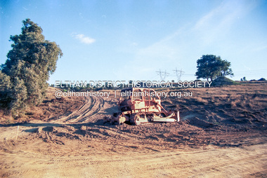 Eltham District Historical Society Inc
Photograph (Item) - Negative, Sean Brady, Untitled (New Subdivision), 1988
Sean Brady 1988 Entrant No. 145 Ref: Series 34, Items 33, 34, 105, 106 The images in this record were not selected for inclusion. SHIRE OF ELTHAM COMMUNITY PHOTOGRAPHIC SURVEY Photography is an artform which many of us practice, sometimes purely for artistic pursuit, sometimes to record the people and events in our lives. In 1988, as part of a local Bicentennial project, the Shire of Eltham conducted the Eltham Community Photographic Survey. Up to 100 entries were to be selected by a panel of photographers for entry into the Eltham Photographic Survey Exhibition. Entries had to be submitted by May 13, 1988. Entrants whose images were selected for the exhibition were contacted and requested to further submit an entry form providing entrant’s name, area of residence, age, and proposed captions. These details were then used to produce labels for the exhibition mounts. Where negatives had not been supplied, these were requested to support the display of printed enlargements mounted on 10” x 8” cardboard. The mounted prints were made available post exhibition for sale at $8.50 each for colour prints and $7.00 for B&W prints. Residents in the Shire were invited to collect a free roll of film and take a photograph of what they either liked or did not like about the area. A total of 160 entrants submitted multiple entries for the exhibition. Of those selected for exhibition, entrants ranged in age from 9 to 70 years. All custom colour and black and white printing for the exhibition was completed by Wattle Studios of Eltham. The Eltham Photographic Survey was jointly auspiced by the Shire of Eltham and Wattle Studios, of 953 Main Road, Eltham. The project was greatly assisted by: • David McRitchie, Media Studies Lecturer Victoria College, Rusden Campus. • Ian and Annette Toohill of Wattle Studios • Tracy Naughton, Eltham Community Arts Officer • Neville Emerson Pty. Ltd. • Superior Press, Eltham • Kodak Australasia Pty. Ltd. • Agfa Gevaert Ltd. • Townsend Colourtech Pty. Ltd. • The Australian Bicentennial Authority • Eleanor Bowers, Secretary, Eltham Arts Council The exhibition was placed on display in the Woolworths Arcade, Eltham between Monday June 6th and Saturday June 11, 1988. It was also intended to hold the exhibition at a venue in the Shire’s North Riding from Monday, June 20 to Friday June 24. It was then displayed at the Were Street Theatre, Montmorency from Friday, June 24 to Thursday, July 7. Series 34: Eltham Community Photographic Survey 1988 - Prints & Documentation Series consists of 117 photographs of Shire scenes taken by members of the community. Items I - 41 are larger photographs mounted on card, which were exhibited. Items 42 - 117 are unmounted copies, alternative takes and other entries. Corresponding negatives contained in Series 35: Eltham Community Photographic Survey 1988 – Negatives which consists of 267 colour and B&W negatives and one colour slide of Shire scenes taken by members of the community. The negatives are arranged by the entrant number of the photographer. The Eltham Community Photographic Survey collection is significant to the local community as it was curated by the local community - ordinary people of all ages - representing what they liked and did not like in the area where they lived. It represents an unfiltered representation of the Shire of Eltham as it was in 1988. It also represents one of many projects as part of the national programme of events and celebrations to commemorate the bicentenary. It is a time capsule of life in the 1980s of this urban and rural municipality in Melbourne's north. shire of eltham archives, bicentennial project, eltham community photographic survey, booth court, eltham, film - kodak ga 100 5095, griffin court, housing estate, power transmission lines, real estate development, reynolds road, scan - 35mm negative, sean brady, series 35, subdivison lots, woodhaven estate -
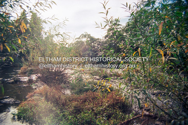 Eltham District Historical Society Inc
Photograph (Item) - Negative, Sean Brady, Yarra River, Eltham, 1988
Sean Brady 1988 Entrant No. 145 Ref: Series 34, Items 33, 34, 105, 106 The images in this record were not selected for inclusion. SHIRE OF ELTHAM COMMUNITY PHOTOGRAPHIC SURVEY Photography is an artform which many of us practice, sometimes purely for artistic pursuit, sometimes to record the people and events in our lives. In 1988, as part of a local Bicentennial project, the Shire of Eltham conducted the Eltham Community Photographic Survey. Up to 100 entries were to be selected by a panel of photographers for entry into the Eltham Photographic Survey Exhibition. Entries had to be submitted by May 13, 1988. Entrants whose images were selected for the exhibition were contacted and requested to further submit an entry form providing entrant’s name, area of residence, age, and proposed captions. These details were then used to produce labels for the exhibition mounts. Where negatives had not been supplied, these were requested to support the display of printed enlargements mounted on 10” x 8” cardboard. The mounted prints were made available post exhibition for sale at $8.50 each for colour prints and $7.00 for B&W prints. Residents in the Shire were invited to collect a free roll of film and take a photograph of what they either liked or did not like about the area. A total of 160 entrants submitted multiple entries for the exhibition. Of those selected for exhibition, entrants ranged in age from 9 to 70 years. All custom colour and black and white printing for the exhibition was completed by Wattle Studios of Eltham. The Eltham Photographic Survey was jointly auspiced by the Shire of Eltham and Wattle Studios, of 953 Main Road, Eltham. The project was greatly assisted by: • David McRitchie, Media Studies Lecturer Victoria College, Rusden Campus. • Ian and Annette Toohill of Wattle Studios • Tracy Naughton, Eltham Community Arts Officer • Neville Emerson Pty. Ltd. • Superior Press, Eltham • Kodak Australasia Pty. Ltd. • Agfa Gevaert Ltd. • Townsend Colourtech Pty. Ltd. • The Australian Bicentennial Authority • Eleanor Bowers, Secretary, Eltham Arts Council The exhibition was placed on display in the Woolworths Arcade, Eltham between Monday June 6th and Saturday June 11, 1988. It was also intended to hold the exhibition at a venue in the Shire’s North Riding from Monday, June 20 to Friday June 24. It was then displayed at the Were Street Theatre, Montmorency from Friday, June 24 to Thursday, July 7. Series 34: Eltham Community Photographic Survey 1988 - Prints & Documentation Series consists of 117 photographs of Shire scenes taken by members of the community. Items I - 41 are larger photographs mounted on card, which were exhibited. Items 42 - 117 are unmounted copies, alternative takes and other entries. Corresponding negatives contained in Series 35: Eltham Community Photographic Survey 1988 – Negatives which consists of 267 colour and B&W negatives and one colour slide of Shire scenes taken by members of the community. The negatives are arranged by the entrant number of the photographer. The Eltham Community Photographic Survey collection is significant to the local community as it was curated by the local community - ordinary people of all ages - representing what they liked and did not like in the area where they lived. It represents an unfiltered representation of the Shire of Eltham as it was in 1988. It also represents one of many projects as part of the national programme of events and celebrations to commemorate the bicentenary. It is a time capsule of life in the 1980s of this urban and rural municipality in Melbourne's north. shire of eltham archives, bicentennial project, eltham community photographic survey, eltham, film - kodak ga 100 5095, scan - 35mm negative, sean brady, series 35, yarra river -
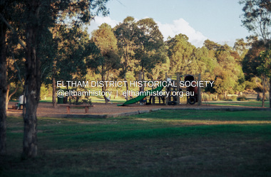 Eltham District Historical Society Inc
Photograph (Item) - Print, Sean Brady, Untitled (Playground Scene), 1988
Eltham Town Park was partially constructed on a tip site. The park and lake were landscaped in 1973-1974. As early as late 1980 a proposal to rename it Alistair Knox Park was met with significant community resistance with a petition of 1600 signatures against however Council ultimately pushed the name through in 1987. Many residents continued to call it Eltham Town Park for some years later. Sean Brady 1988 Entrant No. 145 Ref: Series 34, Items 33, 34, 105, 106 SHIRE OF ELTHAM COMMUNITY PHOTOGRAPHIC SURVEY Photography is an artform which many of us practice, sometimes purely for artistic pursuit, sometimes to record the people and events in our lives. In 1988, as part of a local Bicentennial project, the Shire of Eltham conducted the Eltham Community Photographic Survey. Up to 100 entries were to be selected by a panel of photographers for entry into the Eltham Photographic Survey Exhibition. Entries had to be submitted by May 13, 1988. Entrants whose images were selected for the exhibition were contacted and requested to further submit an entry form providing entrant’s name, area of residence, age, and proposed captions. These details were then used to produce labels for the exhibition mounts. Where negatives had not been supplied, these were requested to support the display of printed enlargements mounted on 10” x 8” cardboard. The mounted prints were made available post exhibition for sale at $8.50 each for colour prints and $7.00 for B&W prints. Residents in the Shire were invited to collect a free roll of film and take a photograph of what they either liked or did not like about the area. A total of 160 entrants submitted multiple entries for the exhibition. Of those selected for exhibition, entrants ranged in age from 9 to 70 years. All custom colour and black and white printing for the exhibition was completed by Wattle Studios of Eltham. The Eltham Photographic Survey was jointly auspiced by the Shire of Eltham and Wattle Studios, of 953 Main Road, Eltham. The project was greatly assisted by: • David McRitchie, Media Studies Lecturer Victoria College, Rusden Campus. • Ian and Annette Toohill of Wattle Studios • Tracy Naughton, Eltham Community Arts Officer • Neville Emerson Pty. Ltd. • Superior Press, Eltham • Kodak Australasia Pty. Ltd. • Agfa Gevaert Ltd. • Townsend Colourtech Pty. Ltd. • The Australian Bicentennial Authority • Eleanor Bowers, Secretary, Eltham Arts Council The exhibition was placed on display in the Woolworths Arcade, Eltham between Monday June 6th and Saturday June 11, 1988. It was also intended to hold the exhibition at a venue in the Shire’s North Riding from Monday, June 20 to Friday June 24. It was then displayed at the Were Street Theatre, Montmorency from Friday, June 24 to Thursday, July 7. Series 34: Eltham Community Photographic Survey 1988 - Prints & Documentation Series consists of 117 photographs of Shire scenes taken by members of the community. Items I - 41 are larger photographs mounted on card, which were exhibited. Items 42 - 117 are unmounted copies, alternative takes and other entries. Corresponding negatives contained in Series 35: Eltham Community Photographic Survey 1988 – Negatives which consists of 267 colour and B&W negatives and one colour slide of Shire scenes taken by members of the community. The negatives are arranged by the entrant number of the photographer. The Eltham Community Photographic Survey collection is significant to the local community as it was curated by the local community - ordinary people of all ages - representing what they liked and did not like in the area where they lived. It represents an unfiltered representation of the Shire of Eltham as it was in 1988. It also represents one of many projects as part of the national programme of events and celebrations to commemorate the bicentenary. It is a time capsule of life in the 1980s of this urban and rural municipality in Melbourne's north. Front: Entrant No. and name on printed label Rear: Entrant No., name and address on printed label; also 'Series 34' and the 'Item No.' in pencilshire of eltham archives, bicentennial project, eltham, eltham community photographic survey, eltham photographic survey exhibition, series 34, series 35, alistair knox park, eltham town park, film - kodak ga 100 5095, scan - 35mm negative, sean brady -
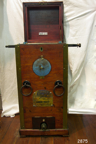 Flagstaff Hill Maritime Museum and Village
Machine - Diving Compressor, Siebe Gorman & Co. Ltd, 1880-1890
This compressor was part of the E.G. Ward Collection. It is connected to the diving suit and boots also in our collection. Siebe Gorman & Company Ltd was a British company that developed diving equipment and breathing equipment and worked on commercial diving and marine salvage projects. The company advertised itself as 'Submarine Engineers'. It was founded by Augustus Siebe, a German-born British engineer chiefly known for his contributions to diving equipment. Siebe Gorman traded as an engineering firm for over 180 years from 1819 to 1999. The early success of the business was due to its founder, the Prussian immigrant Christian 'Augustus' Siebe (1788-1872). For business reasons, he applied for and was granted British citizenship in 1856. He was a gifted engineer who was able to translate theoretical problems into practical, working products. During the industrial Victorian period, the business traded as 'A. Siebe' at 145 High Street Holborn London, but in 1828 new premises were acquired at 5 Denmark Street, Soho. The family firm produced a wide range of manufactured goods including paper-making machinery, measuring machinery, water-pumps, refrigeration equipment and diving apparatus. Augustus Siebe specialised in submarine engineering early on and the company gained a reputation for the manufacture of safe, reliable diving apparatus. Augustus Siebe is best remembered for the development and manufacture of the ‘closed’ Diving Dress based on the ideas of Charles and John Deane, George Edwards and Charles Pasley. Apart from some small modifications to valves and diver communications, the basic 12 bolt ‘closed’ diving dress remained relatively unchanged after the 1870s. Later company successes were also based on innovation, with new products that could be successfully developed and manufactured to high standards. This was largely attributed to the inventive nature, foresight, engineering and entrepreneurial skills of Robert Henry Davis (1870-1965). In 1882, RH Davis joined the company of 'Siebe & Gorman' as a young 11-year-old office boy and he was to remain with the company until he died in 1965. Augustus Siebe retired in 1869 and handed over the company to a new partnership of Henry H. Siebe (1830-1885) and William A. O'Gorman (1834-1904). The new firm traded as 'Siebe & Gorman' (1870-1879) from premises in and around Mason Street, Westminster Bridge Road, Lambeth, London. The two partners soon recognised the potential of R.H. Davis and in 1894, aged 24, he became General Manager of Siebe & Gorman. Davis increasingly ran the company until the surviving partner (W.A. Gorman) died in 1904. The firm was disposed of to the Vickers (armaments) family and a new company 'Siebe Gorman & Co. Ltd.' (1905-1998) was formed. Under the chairmanship of Albert Vickers, R.H. Davis was kept on as Managing Director, and the company forged ahead. However, after WW1, the Great Depression caused manufacturing output and share prices to slump. In 1924 Robert Davis made a deal with the Vickers Board and acquired control of the company through majority shares. Under his leadership, the Siebe Gorman Company flourished and within time, four of his sons also joined the firm. The company gained a worldwide reputation for the manufacture of diving apparatus, decompression and observation chambers, and safety breathing apparatus of all types for use on the land, in the air and under the sea (including mine rescue, tunneling, aircraft, diving, submarine escape and in other hazardous environments). Close research and development links with the MOD (especially the Admiralty), also provided a lucrative outlet for the company products. In 1932, Robert Davis was knighted by King George V, principally for his invention of the ‘Davis Submerged Escape Apparatus’ (D.S.E.A.). Siebe Gorman essentially remained a family firm from the beginning (under A Siebe) until it became a public company for the first time in 1952. However, following WW2, British manufacturing stagnated through stifled investment and post-war austerity, and there was little innovation. Siebe Gorman fortunes began to decline as an ageing Sir Robert Davis failed to invest, or change the company business and management practices. In 1959, Siebe Gorman was acquired by the “Fairy Group” and the ailing Sir Robert was made Life President. Consequently, nothing changed and the slow decline continued until Sir Robert's death in March 1965. Around 1960, Siebe Gorman acquired the diving apparatus manufacturer C E Heinke, and for a brief period, it manufactured some diving equipment under the combined name of Siebe Heinke. Around 1964, Mr. E. 'Barry' Stephens was appointed as the new Managing Director to modernise Siebe Gorman. Changes were made, including a move to a new factory in Wales in 1975. The new company concentrated on fire fighting breathing apparatus and escape equipment, and the move coincided with the loss of many of the older, traditional craft skills. Between 1985 and 1998, Siebe expanded through acquisitions, and several other companies were acquired. The Siebe Gorman (diving apparatus) company has therefore traded as A. Siebe (1819-1870); Siebe & Gorman (1870-1879); Siebe Gorman & Co (1880-1904); Siebe Gorman & Co. Ltd (1905-1998).The compressor is a very significant item as it gives a snapshot into marine history and the development of diving equipment generally especially that used for salvage operations before and during WW2. Siebe & Gorman the company that made the equipment was a leading inventor, developer and innovator of marine equipment with its early helmets and other items eagerly sought after today for collections around the world. The items in the Flagstaff Hill collection give us an insight as to how divers operated and the dangers they faced doing a very necessary and dangerous job during the early days of marine exploration.A single cylinder divers' pump by Siebe Gorman & Co Ltd, London, eccentric hand cranked in brass mounted mahogany case with instructions to the underside of the lid, brass covered pressure gauge and air outlet, brass makers plaque to the front, water inlet and outlet to the rear, green painted lifting rings. Machinery has some blue painted areas on the metal.Plate on the back 'WATER SUPPLY" "WATER OVERFLOW" "WATER DRAIN-IN" Pressure gauge dial "BOURDON'S PRESSURE GAUGE" STEBE GORMAN & CO. LONDON", "LBS PRESSURE" "FEET OF SALT WATER" Plate on the front " PATENT, Siebe Gorman & Co Ltd Submarine Engineers" below emblem (Lion, Crown, Horse)flagstaff hill, warrnambool, flagstaff-hill, maritime-museum, diving compressor, london, siebe gorman & co ltd, marine technology, life saving, deep sea diving, maritime museum, maritime village, manine history -
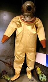 Flagstaff Hill Maritime Museum and Village
Functional object - Diving Suit, boots and weight, 1900
This diving suit with helmet, boots and weight is part of the E.G.Ward collection, along with the diving compressor and a photograph of a diver in this equipment. Siebe Gorman & Company Ltd was a British company that developed diving equipment and breathing equipment and worked on commercial diving and marine salvage projects. The company advertised itself as 'Submarine Engineers'. It was founded by Augustus Siebe, a German-born British engineer chiefly known for his contributions to diving equipment. Siebe Gorman traded as an engineering firm for over 180 years from 1819 to 1999. The early success of the business was due to its founder, the Prussian immigrant Christian 'Augustus' Siebe (1788-1872). For business reasons, he applied for and was granted British citizenship in 1856. He was a gifted engineer who was able to translate theoretical problems into practical, working products. During the industrial Victorian period, the business traded as 'A. Siebe' at 145 High Street Holborn London, but in 1828 new premises were acquired at 5 Denmark Street, Soho. The family firm produced a wide range of manufactured goods including paper-making machinery, measuring machinery, water pumps, refrigeration equipment and diving apparatus. Augustus Siebe specialised in submarine engineering early on and the company gained a reputation for the manufacture of safe, reliable diving apparatus. Augustus Siebe is best remembered for the development and manufacture of the ‘closed’ Diving Dress based on the ideas of Charles and John Deane, George Edwards and Charles Pasley. Apart from some small modifications to valves and diver communications, the basic 12-bolt ‘closed’ diving dress remained relatively unchanged after the 1870s. Later company successes were also based on innovation, with new products that could be successfully developed and manufactured to high standards. This was largely attributed to the inventive nature, foresight, engineering and entrepreneurial skills of Robert Henry Davis (1870-1965). In 1882, RH Davis joined the company of 'Siebe & Gorman' as a young 11-year-old office boy and he was to remain with the company until he died in 1965. Augustus Siebe retired in 1869 and handed over the company to a new partnership of Henry H. Siebe (1830-1885) and William A. O'Gorman (1834-1904). The new firm traded as 'Siebe & Gorman' (1870-1879) from premises in and around Mason Street, Westminster Bridge Road, Lambeth, London. The two partners soon recognised the potential of R.H. Davis and in 1894, aged 24, he became General Manager of Siebe & Gorman. Davis increasingly ran the company until the surviving partner (W.A. Gorman) died in 1904. The firm was disposed of to the Vickers (armaments) family and a new company 'Siebe Gorman & Co. Ltd.' (1905-1998) was formed. Under the chairmanship of Albert Vickers, R.H. Davis was kept on as Managing Director, and the company forged ahead. However, after WW1, the Great Depression caused manufacturing output and share prices to slump. In 1924 Robert Davis made a deal with the Vickers Board and acquired control of the company through majority shares. Under his leadership, the Siebe Gorman Company flourished and within time, four of his sons also joined the firm. The company gained a worldwide reputation for the manufacture of diving apparatus, decompression and observation chambers, and safety breathing apparatus of all types for use on the land, in the air and under the sea (including mine rescue, tunnelling, aircraft, diving, submarine escape and in other hazardous environments). Close research and development links with the MOD (especially the Admiralty), also provided a lucrative outlet for the company products. In 1932, Robert Davis was knighted by King George V, principally for his invention of the ‘Davis Submerged Escape Apparatus’ (D.S.E.A.). Siebe Gorman essentially remained a family firm from the beginning (under A.Siebe) until it became a public company for the first time in 1952. However, following WW2, British manufacturing stagnated through stifled investment and post-war austerity, and there was little innovation. Siebe Gorman fortunes began to decline as an ageing Sir Robert Davis failed to invest, or change the company business and management practices. In 1959, Siebe Gorman was acquired by the “Fairy Group” and the ailing Sir Robert was made Life President. Consequently, nothing changed and the slow decline continued until Sir Robert's death in March 1965. Around 1960, Siebe Gorman acquired the diving apparatus manufacturer C E Heinke, and for a brief period, it manufactured some diving equipment under the combined name of Siebe Heinke. Around 1964, Mr E. 'Barry' Stephens was appointed as the new Managing Director to modernise Siebe Gorman. Changes were made, including a move to a new factory in Wales in 1975. The new company concentrated on fire-fighting breathing apparatus and escape equipment, and the move coincided with the loss of many of the older, traditional craft skills. Between 1985 and 1998, Siebe expanded through acquisitions, and several other companies were acquired. The Siebe Gorman (diving apparatus) company has therefore traded as A. Siebe (1819-1870); Siebe & Gorman (1870-1879); Siebe Gorman & Co (1880-1904); Siebe Gorman & Co. Ltd (1905-1998).The items are very significant as a snapshot into marine history and the development of diving equipment generally especially that used for salvage operations before and during WW2. The company that made the equipment was a leading inventor,developer and innovator of marine equipment with its early helmets and other items eagerly sought after today for collections around the world. The items in the Flagstaff Hill collection give us an insight as to how divers operated and the dangers they faced doing a very necessary and dangerous job.Diving suit including helmet, boots and a weight. Diving suit is made of canvas with knitted cuffs. The helmet is metal. The boots have a thick sole and thick leather upper that is held on with leather straps and buckles. The toe of the boot is heavy metal. The weight is worn next to the trunk of the diver and it has an inscription to mark the front. It is worn with straps and buckles holding it in place. Royal Navy Admiralty Pattern 6 bolt No 3 light Siebe Gorman light diving helmet circa 1960 used by the Royal Navy before and after World War 2"Siebe Gorman & Co Ltd Marine Engineers London. Patent" with "E G Ward" on front and back plate. On weight "FRONT"flagstaff hill, warrnambool, diving suit, siebe gorman and co ltd., siebe gorman and co ltd marine engineers london, marine engineers, diving helmet, diving boots, diving weight, marine diving, maritimemuseum, maritime village, maritime history, marine technology, life saving, deep sea diving -
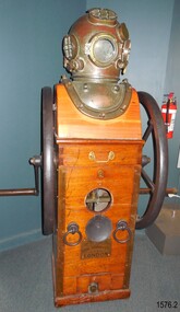 Flagstaff Hill Maritime Museum and Village
Equipment - Diving compressor and helmet, 1944
Siebe Gorman & Company Ltd was a British company that developed diving equipment and breathing equipment and worked on commercial diving and marine salvage projects. The company advertised itself as 'Submarine Engineers'. It was founded by Augustus Siebe, a German-born British engineer chiefly known for his contributions to diving equipment. Siebe Gorman traded as an engineering firm for over 180 years from 1819 to 1999. The early success of the business was due to its founder, the Prussian immigrant Christian 'Augustus' Siebe (1788-1872). For business reasons, he applied for and was granted British citizenship in 1856. He was a gifted engineer who was able to translate theoretical problems into practical, working products. During the industrial Victorian period, the business traded as 'A. Siebe' at 145 High Street Holborn London, but in 1828 new premises were acquired at 5 Denmark Street, Soho. The family firm produced a wide range of manufactured goods including paper-making machinery, measuring machinery, water pumps, refrigeration equipment, and diving apparatus. Augustus Siebe specialised in submarine engineering early on and the company gained a reputation for the manufacture of safe, reliable diving apparatus. Augustus Siebe is best remembered for the development and manufacture of the ‘closed’ Diving Dress based on the ideas of Charles and John Deane, George Edwards, and Charles Pasley. Apart from some small modifications to valves and diver communications, the basic 12 bolt ‘closed’ diving dress remained relatively unchanged after the 1870s. Later company successes were also based on innovation, with new products that could be successfully developed and manufactured to high standards. This was largely attributed to the inventive nature, foresight, engineering, and entrepreneurial skills of Robert Henry Davis (1870-1965). In 1882, RH Davis joined the company of 'Siebe & Gorman' as a young 11-year-old office boy and he was to remain with the company until he died in 1965. Augustus Siebe retired in 1869 and handed over the company to a new partnership of Henry H. Siebe (1830-1885) and William A. O'Gorman (1834-1904). The new firm traded as 'Siebe & Gorman' (1870-1879) from premises in and around Mason Street, Westminster Bridge Road, Lambeth, London. The two partners soon recognised the potential of R.H. Davis and in 1894, aged 24, he became General Manager of Siebe & Gorman. Davis increasingly ran the company until the surviving partner (W.A. Gorman) died in 1904. The firm was disposed of to the Vickers (armaments) family and a new company 'Siebe Gorman & Co. Ltd.' (1905-1998) was formed. Under the chairmanship of Albert Vickers, R.H. Davis was kept on as Managing Director, and the company forged ahead. However, after WW1, the Great Depression caused manufacturing output and share prices to slump. In 1924 Robert Davis made a deal with the Vickers Board and acquired control of the company through majority shares. Under his leadership, the Siebe Gorman Company flourished and within time, four of his sons also joined the firm. The company gained a worldwide reputation for the manufacture of diving apparatus, decompression and observation chambers, and safety breathing apparatus of all types for use on the land, in the air, and under the sea (including mine rescue, tunneling, aircraft, diving, submarine escape and in other hazardous environments). Close research and development links with the MOD (especially the Admiralty), also provided a lucrative outlet for the company products. In 1932, Robert Davis was knighted by King George V, principally for his invention of the ‘Davis Submerged Escape Apparatus’ (D.S.E.A.). Siebe Gorman essentially remained a family firm from the beginning (under A.Siebe) until it became a public company for the first time in 1952. However, following WW2, British manufacturing stagnated through stifled investment and post-war austerity, and there was little innovation. Siebe Gorman's fortunes began to decline as an aging Sir Robert Davis failed to invest, or change the company's business and management practices. In 1959, Siebe Gorman was acquired by the “Fairy Group” and the ailing Sir Robert was made Life President. Consequently, nothing changed and the slow decline continued until Sir Robert's death in March 1965. Around 1960, Siebe Gorman acquired the diving apparatus manufacturer C E Heinke, and for a brief period, it manufactured some diving equipment under the combined name of Siebe Heinke. Around 1964, Mr E. 'Barry' Stephens was appointed as the new Managing Director to modernise Siebe Gorman. Changes were made, including a move to a new factory in Wales in 1975. The new company concentrated on fire-fighting breathing apparatus and escape equipment, and the move coincided with the loss of many of the older, traditional craft skills. Between 1985 and 1998, Siebe expanded through acquisitions, and several other companies were acquired. The Siebe Gorman (diving apparatus) company has therefore traded as A. Siebe (1819-1870); Siebe & Gorman (1870-1879); Siebe Gorman & Co (1880-1904); Siebe Gorman & Co. Ltd (1905-1998). (For information regards the diving helmet & Frank King see Notes Section at the end of this document)The items are very significant as a snapshot into marine history and the development of diving equipment generally especially that used for salvage operations before and during WW2. The company that made the equipment was a leading inventor,developer and innovator of marine equipment with its early helmets and other items eagerly sought after today for collections around the world. The items in the Flagstaff Hill collection give us an insight as to how divers operated and the dangers they faced doing a very necessary and dangerous job. Frank Kings' diving helmet and compressor (communication pipe stored separately). Compressor is hand cranked. US Navy diving helmet, Mark V. Two maker's plates attached. Made in 1944.On rear "WATER SUPPLY" On front 'PATENT" " Logo: Images (Lion, Crown, Horse, Shield within an oval) "SIEBE, GORMAN & Co. Ltd. SUBMARINE ENGINEERS, LONDON.flagstaff hill, warrnambool, maritime museum, great ocean road, us navy diving helmet, commonwealth government salvage, diving helmet, marine salvage, frank king, diver, siebe. gorman & co ltd, submarine equipment, diving equipment, communication under water, hand cranked, diving compressor -
 Eltham District Historical Society Inc
Photograph - Aerial Photograph, Landata, Eltham; Crown Allotment 15, Section 5, Parish of Nillumbik (Stokes Orchard Estate), Dec. 1945
Centred on present day Diosma Rd, Stokes Pl, Nyora Rd and Eucalyptus Rd Historic Aerial Imagery Source: Landata.vic.gov.au Aerial Photo Details: Project No :5 Project : MELBOURNE AND METROPOLITAN AREA PROJECT Run : 36 Frame : 60546 Date : 12/1945 Film Type : B/W Camera : EAG4 Flying Height : 10200 Scale : 6000 Film Number : 195 GDA2020 : 37°42'47"S, 145°09'56"E MGA2020 : 338306, 5824438 (55) Melways : 22 C4 (ed. 42) A History of the Development of Crown Allotment 15, Section 5, Parish of Nillumbik – Stokes Orchard Crown Allotment 15, Section 5, Parish of Nillumbik (CA15) is a square allotment of 158 acres or approximately a quarter of a square mile. It lies just beyond the eastern end of Pitt Street, south of Nyora Road to the northern end of Eucalyptus Road and extends east from Eucalyptus Road to Reynolds Road. The topography of CA15 is generally steep, sloping up to a hill near the centre of the land, the ridgeline passing through the properties along the southern side of Diosma Road. Eucalyptus Road is a straight north-south road with its northern end at the north west corner of CA15. Until the end of the 1970s this road was an un-named Government Road and was largely not open to traffic. With residential development in the 1970s the road was constructed, and the council allocated the name obviously in recognition of the predominant species of the local bushland. CA15 was purchased from the Crown by George D’Arley Boursiquot, a prominent Melbourne printer, on 28th October 1852. On November 23, 1922, former Member for Gippsland and Melbourne Real Estate Agent, Hubert Patrick Keogh purchased the allotment then sold it March 13, 1925, to local farmer, Robert David Taylor, a former Shire of Eltham Councillor (1911-1920) and Shire President (1919). Taylor had extensive land holdings stretching west towards Bible Street and Main Road. The Taylor home was situated at the top of the hill in Bible Street at present day 82 Bible Street. At the time of Taylor’s purchase in 1925, CA15 was subdivided into 48 lots that could be described as small rural properties or large residential lots. A typical lot size was one hectare or 2.5 acres. The subdivision created two roads, Nyora Road, and Diosma Road, each following an irregular alignment between Eucalyptus and Reynolds Roads. However, the lots were not sold off separately nor were the roads constructed. The land effectively remained as one parcel for many further years. Robert David Taylor died November 30, 1934, and probate was granted to his son of the same name, Robert David Taylor of Bible Street, Salesman and William McLelland Vance Taylor of 73 Emmeline Street, Northcote, Clerk, with the transfer of the land into their names on July 8, 1935. Frank Stokes worked as a qualified accountant at Kennons leather factory in Burnley, while living at 1 Thomas Street, Mitcham. He suffered from migraines and wanted to return to working the land (he had previously worked on farms and orchards since coming to Australia from England in 1926, both in WA and Vic.). He first travelled to the district by train in July 1942 to find land with the intention to establish an orchard. By chance he met Arthur Bird of Bird Orchard (bounded by Pitt Street, Eucalyptus Road, and Wattle Grove) and they got talking over their common interest. Arthur put Frank up for the night and pointed out the land, 158 acres- part of the Taylor Estate- £900, Crown Allotment 15, Section 5, Parish of Nillumbik (CA15) somewhat diagonally opposite Bird Orchard. Stokes applied through the Riverina Agency to purchase the land who in turn applied for permission from Canberra to sell as there was a new government regulation introduced during the Second World War banning land sales except for immediate production. Stokes obtained a loan on his Mitcham house of £600 @ 5% and paid £450 deposit with quarterly payments of £15 spread over 5 years. Stokes was assisted and advised by Arthur Bird who farmed the neighbouring orchard. In early 1943 Stokes took possession and would catch the train out to Eltham on Fridays after work and began building a hut on the corner of Nyora Road and the Government Road (Eucalyptus Road) for shelter and to lock up tools. He established an orchard on the central western part of the land through the centre of which ran a natural waterway (part of the present-day linear park) and was able to pay a neighbour (Hawkins) to help with clearing and fencing 25 acres, and with a horse and single furrowed plough, planted approximately 2,500 fruit trees - cherries, peaches, plums, almonds, pears, apricots and lemons as well as a few apples and oranges; a massive task. Aerial photographs from the 1940s through to the 1990s clearly show the orchard with most of the larger CA15 site remaining as natural bushland. A huge problem was hares and rabbits eating all the new buds off the tiny trees. As well as laying poison he painted the trees with a mixture of cow manure and lime, often working by moonlight. Procurement of wire and wire netting was difficult because of the war but after much effort he obtained a permit from the Agricultural Department for supplies in March 1944. In February 1945 Stokes applied for a permit to build a “packing shed” as no house building was allowed. It was to be 33 feet x 21 feet and cost £312. It was constructed mostly from second-hand materials, which were hard to obtain, especially iron for roofing. Stokes finished work at Kennons on October 31, 1945, and in March 1946 he sold the family home at Mitcham for £1,230 plus £170 for furniture. On May 15, 1946, title to the CA15 property was issued to Frank Howard Alfred Stokes, Orchardist and Gladys Ethel Stokes, Married Woman, both of Pitt Street, Eltham. The family of five then moved into the very unfinished “packing shed” at Eltham, which was a struggle to weatherproof. Eventually rooms were divided off and lined with hessian bags and whitewashed. Their income was firewood (cut and sold), selling rockery stones and cut Sweet Bursaria. (It was discovered during the 1940s that Sweet Bursaria contained the sunscreen compound Aesculin. The RAAF utilised this compound from Sweet Bursaria during WW2 for pilots and gunners.) The orchard’s first fruit sale was a half-case of Le Vanq peaches in December 1947 for the price of 8 shillings. In 1956 plans for house were drawn and Glen Iris bricks purchased (1956 Olympic Rings variant). The building of the house commenced in 1957 - 12 feet of original packing shed was removed – and was completed in 1959. Water was connected from newly built pressure storage on the property at the end of 1959 and the electricity connection for the first time at 3pm on April 29, 1960. The house remains to present day (somewhat modified) at 1 Nyora Road, home to Nyora Studio Gallery. On occasions, spare remnants of the 1956 bricks have been known to be unearthed in gardens on the estate as they were utilised by Frank Stokes to fill in rabbit holes. On May 26, 1950, a parcel of land was compulsorily acquired by the Melbourne and Metropolitan Board of Works on the hilltop to establish an easement for a high-level service reservoir to augment Eltham’s water supply. The project also included pipe tracks for the necessary water mains. The reservoir has now been superseded by higher level water tanks east of Reynolds Road and its former site is now a public reserve. On November 27, 1964, the State Electricity Commission served notice to compulsorily acquire a further parcel through the eastern part of the land for a major electricity transmission line that augmented supply from the La Trobe Valley to Melbourne. The easement was registered February 11, 1966. The easement was widened July 18, 1969 for a second transmission line to be constructed. In 1971 Melbourne Metropolitan Planning Scheme amendments adopted Nyora Road as the boundary between a residential zone to the north and a rural zone to the south. This determined the future development of the land. In the mid-1970s the Shire of Eltham divided the orchard into numerous rate-able parcel lots, the 48 lots having been established in 1925 and the subsequent rates assessment proved unsustainable for Stokes. He commenced selling lots outside the boundary of the orchard, north of Diosma and South of Nyora. However shortly later the land between Nyora and Diosma Roads and west of the electricity easement was sold and subdivided into residential lots, a housing development by Macquarie Builders and marketed as the Stokes Orchard Estate. New streets were created, and most were named after trees, although one, Stokes Place, commemorates the former owners. The development was undertaken in two stages; Stage 1 (1975) encompassing Scarlet Ash Court, Ironbark Close and Peppermint Grove bounded by Nyora and Eucalyptus roads and Stage 2 (1978) encompassing Stokes Place, Orchard Way, The Crest and The Lookout bound by Nyora and Diosma roads. The developer, Macquarie Builders went bankrupt shortly after the release of Stage 2 leaving many purchasers to fend for themselves and arrange for their own independent builders. There were also difficulties with sewerage for the land immediately south of Diosma Road and so the conventional residential lots were abandoned in favour of larger lots. The development of Orchard Way, The Crest and The Lookout did not proceed as planned and the proposed lots were incorporated into five-acre parcels instead. These included a low-density group housing development by the Graves family and the award winning Choong House (1983) with Gordon Ford developed garden immediately next door situated on the ridge of the hill nestled amongst the original bush, Eucalypt trees and Sweet Bursaria. In 1994, Nillumbik Shire Council applied Significant Environment and Significant Landscape overlays upon the properties on the south side of Diosma Road to ensure protection of this natural bush garden environment. With the arrival of the sewer along Diosma Road in the 1990s, most of these five-acre parcels have since been subdivided multiple times. The Choong house presently sits on a 2.7-acre property, which in 2022 Nillumbik Council nominated for Cultural Significance Heritage protection and is considered potentially significant at State level. The Stokes family were also associated with the Eltham Christian Church. In the 1970s this church had met in temporary premises in Eltham. Lots of the original 1925 subdivision remained south of Nyora Road and a number of these lots were utilized for the Eltham Christian School, which was established by the Eltham Christian Church in 1981. The school operated on this site until 2000. The premises are now used by The Vine Baptist Church. By the mid-1980s the whole of CA15 had been developed for residential and school purposes, except for the sections north of Diosma Road and between the transmission lines and Reynolds Road. Sewerage issues had been resolved for the section north of Diosma Road and in 1987 it was in the process of being subdivided into residential lots. The development coincided with the discovery of colonies of the rare and endangered Eltham Copper Butterfly on the site. This resulted in a community and political campaign to save the butterfly habitat. With the co-operation of the land developer the subdivision was altered to create two bushland reserves in the critical butterfly habitat areas. In the late 1980s the State Government was investigating options for establishing a metropolitan ring road link between Diamond Creek and Ringwood. The chosen route was adjacent to Reynolds Road and so this created a freeze on development of CA15 between Reynolds Road and the electricity easement. The ring road proposal was eventually abandoned, and this part of the land was subdivided into low density residential lots. Diosma Road has been discontinued at the electricity easement and the eastern part incorporated into View Mount Court with access from Reynolds Road. The whole of CA15 has now been developed for residential or associated purposes, ranging from conventional density to quite low density south of Nyora Road. Some remnants of the orchard remain, a few cherry trees on the Graves property and a lone apple tree in Stokes Place. The butterfly reserves comprise significant areas of remnant bushland. Linear reserves through the estate link with central Eltham via the Woodridge linear reserve and with Research along the electricity easement. CA15 as it exists today has a complicated history of rural use, Government acquisition, urban development, and community action. References: • “Stokes Orchard, an incomplete history”; Russell Yeoman with Doug Orford • Correspondence, Beryl Bradbury (nee Stokes) • Aerial Photographs, 1931-1991, Landata (landata.vic.gov.au) • Certificate of Title, Vol. 4930 Fol. 985900 • Plan Number LP 10859 aerial photo, diosma road, eltham copper butterfly, eucalyptus road, ironbark close, nyora road, peppermint grove, peter & elizabeth pidgeon collection, power transmission lines, reynolds road, scarlet ash court, stokes orchard estate, stokes place, woodridge estate, frank stokes -
 Eltham District Historical Society Inc
Photograph - Aerial Photograph, Landata, Eltham; Crown Allotment 15, Section 5, Parish of Nillumbik (Stokes Orchard Estate), Nov. 1931
Centred over present day Reynolds Road and Mount Pleasant Road, Eltham (including Diosma Rd, Stokes Pl, Nyora Rd and Eucalyptus Rd) Historic Aerial Imagery Source: Landata.vic.gov.au Aerial Photo Details: Project No :1931 Project : MALDON PRISON Run : 21 Frame : 3160 Date : 11/1931 Film Type : B/W Camera : F8 Flying Height : 11000 Scale : 18860 Film Number : 60 GDA2020 : 37°43'31"S, 145°10'20"E MGA2020 : 338912, 5823086 (55) Melways : 22 E8 (ed. 42) A History of the Development of Crown Allotment 15, Section 5, Parish of Nillumbik – Stokes Orchard Crown Allotment 15, Section 5, Parish of Nillumbik (CA15) is a square allotment of 158 acres or approximately a quarter of a square mile. It lies just beyond the eastern end of Pitt Street, south of Nyora Road to the northern end of Eucalyptus Road and extends east from Eucalyptus Road to Reynolds Road. The topography of CA15 is generally steep, sloping up to a hill near the centre of the land, the ridgeline passing through the properties along the southern side of Diosma Road. Eucalyptus Road is a straight north-south road with its northern end at the north west corner of CA15. Until the end of the 1970s this road was an un-named Government Road and was largely not open to traffic. With residential development in the 1970s the road was constructed, and the council allocated the name obviously in recognition of the predominant species of the local bushland. CA15 was purchased from the Crown by George D’Arley Boursiquot, a prominent Melbourne printer, on 28th October 1852. On November 23, 1922, former Member for Gippsland and Melbourne Real Estate Agent, Hubert Patrick Keogh purchased the allotment then sold it March 13, 1925, to local farmer, Robert David Taylor, a former Shire of Eltham Councillor (1911-1920) and Shire President (1919). Taylor had extensive land holdings stretching west towards Bible Street and Main Road. The Taylor home was situated at the top of the hill in Bible Street at present day 82 Bible Street. At the time of Taylor’s purchase in 1925, CA15 was subdivided into 48 lots that could be described as small rural properties or large residential lots. A typical lot size was one hectare or 2.5 acres. The subdivision created two roads, Nyora Road, and Diosma Road, each following an irregular alignment between Eucalyptus and Reynolds Roads. However, the lots were not sold off separately nor were the roads constructed. The land effectively remained as one parcel for many further years. Robert David Taylor died November 30, 1934, and probate was granted to his son of the same name, Robert David Taylor of Bible Street, Salesman and William McLelland Vance Taylor of 73 Emmeline Street, Northcote, Clerk, with the transfer of the land into their names on July 8, 1935. Frank Stokes worked as a qualified accountant at Kennons leather factory in Burnley, while living at 1 Thomas Street, Mitcham. He suffered from migraines and wanted to return to working the land (he had previously worked on farms and orchards since coming to Australia from England in 1926, both in WA and Vic.). He first travelled to the district by train in July 1942 to find land with the intention to establish an orchard. By chance he met Arthur Bird of Bird Orchard (bounded by Pitt Street, Eucalyptus Road, and Wattle Grove) and they got talking over their common interest. Arthur put Frank up for the night and pointed out the land, 158 acres- part of the Taylor Estate- £900, Crown Allotment 15, Section 5, Parish of Nillumbik (CA15) somewhat diagonally opposite Bird Orchard. Stokes applied through the Riverina Agency to purchase the land who in turn applied for permission from Canberra to sell as there was a new government regulation introduced during the Second World War banning land sales except for immediate production. Stokes obtained a loan on his Mitcham house of £600 @ 5% and paid £450 deposit with quarterly payments of £15 spread over 5 years. Stokes was assisted and advised by Arthur Bird who farmed the neighbouring orchard. In early 1943 Stokes took possession and would catch the train out to Eltham on Fridays after work and began building a hut on the corner of Nyora Road and the Government Road (Eucalyptus Road) for shelter and to lock up tools. He established an orchard on the central western part of the land through the centre of which ran a natural waterway (part of the present-day linear park) and was able to pay a neighbour (Hawkins) to help with clearing and fencing 25 acres, and with a horse and single furrowed plough, planted approximately 2,500 fruit trees - cherries, peaches, plums, almonds, pears, apricots and lemons as well as a few apples and oranges; a massive task. Aerial photographs from the 1940s through to the 1990s clearly show the orchard with most of the larger CA15 site remaining as natural bushland. A huge problem was hares and rabbits eating all the new buds off the tiny trees. As well as laying poison he painted the trees with a mixture of cow manure and lime, often working by moonlight. Procurement of wire and wire netting was difficult because of the war but after much effort he obtained a permit from the Agricultural Department for supplies in March 1944. In February 1945 Stokes applied for a permit to build a “packing shed” as no house building was allowed. It was to be 33 feet x 21 feet and cost £312. It was constructed mostly from second-hand materials, which were hard to obtain, especially iron for roofing. Stokes finished work at Kennons on October 31, 1945, and in March 1946 he sold the family home at Mitcham for £1,230 plus £170 for furniture. On May 15, 1946, title to the CA15 property was issued to Frank Howard Alfred Stokes, Orchardist and Gladys Ethel Stokes, Married Woman, both of Pitt Street, Eltham. The family of five then moved into the very unfinished “packing shed” at Eltham, which was a struggle to weatherproof. Eventually rooms were divided off and lined with hessian bags and whitewashed. Their income was firewood (cut and sold), selling rockery stones and cut Sweet Bursaria. (It was discovered during the 1940s that Sweet Bursaria contained the sunscreen compound Aesculin. The RAAF utilised this compound from Sweet Bursaria during WW2 for pilots and gunners.) The orchard’s first fruit sale was a half-case of Le Vanq peaches in December 1947 for the price of 8 shillings. In 1956 plans for house were drawn and Glen Iris bricks purchased (1956 Olympic Rings variant). The building of the house commenced in 1957 - 12 feet of original packing shed was removed – and was completed in 1959. Water was connected from newly built pressure storage on the property at the end of 1959 and the electricity connection for the first time at 3pm on April 29, 1960. The house remains to present day (somewhat modified) at 1 Nyora Road, home to Nyora Studio Gallery. On occasions, spare remnants of the 1956 bricks have been known to be unearthed in gardens on the estate as they were utilised by Frank Stokes to fill in rabbit holes. On May 26, 1950, a parcel of land was compulsorily acquired by the Melbourne and Metropolitan Board of Works on the hilltop to establish an easement for a high-level service reservoir to augment Eltham’s water supply. The project also included pipe tracks for the necessary water mains. The reservoir has now been superseded by higher level water tanks east of Reynolds Road and its former site is now a public reserve. On November 27, 1964, the State Electricity Commission served notice to compulsorily acquire a further parcel through the eastern part of the land for a major electricity transmission line that augmented supply from the La Trobe Valley to Melbourne. The easement was registered February 11, 1966. The easement was widened July 18, 1969 for a second transmission line to be constructed. In 1971 Melbourne Metropolitan Planning Scheme amendments adopted Nyora Road as the boundary between a residential zone to the north and a rural zone to the south. This determined the future development of the land. In the mid-1970s the Shire of Eltham divided the orchard into numerous rate-able parcel lots, the 48 lots having been established in 1925 and the subsequent rates assessment proved unsustainable for Stokes. He commenced selling lots outside the boundary of the orchard, north of Diosma and South of Nyora. However shortly later the land between Nyora and Diosma Roads and west of the electricity easement was sold and subdivided into residential lots, a housing development by Macquarie Builders and marketed as the Stokes Orchard Estate. New streets were created, and most were named after trees, although one, Stokes Place, commemorates the former owners. The development was undertaken in two stages; Stage 1 (1975) encompassing Scarlet Ash Court, Ironbark Close and Peppermint Grove bounded by Nyora and Eucalyptus roads and Stage 2 (1978) encompassing Stokes Place, Orchard Way, The Crest and The Lookout bound by Nyora and Diosma roads. The developer, Macquarie Builders went bankrupt shortly after the release of Stage 2 leaving many purchasers to fend for themselves and arrange for their own independent builders. There were also difficulties with sewerage for the land immediately south of Diosma Road and so the conventional residential lots were abandoned in favour of larger lots. The development of Orchard Way, The Crest and The Lookout did not proceed as planned and the proposed lots were incorporated into five-acre parcels instead. These included a low-density group housing development by the Graves family and the award winning Choong House (1983) with Gordon Ford developed garden immediately next door situated on the ridge of the hill nestled amongst the original bush, Eucalypt trees and Sweet Bursaria. In 1994, Nillumbik Shire Council applied Significant Environment and Significant Landscape overlays upon the properties on the south side of Diosma Road to ensure protection of this natural bush garden environment. With the arrival of the sewer along Diosma Road in the 1990s, most of these five-acre parcels have since been subdivided multiple times. The Choong house presently sits on a 2.7-acre property, which in 2022 Nillumbik Council nominated for Cultural Significance Heritage protection and is considered potentially significant at State level. The Stokes family were also associated with the Eltham Christian Church. In the 1970s this church had met in temporary premises in Eltham. Lots of the original 1925 subdivision remained south of Nyora Road and a number of these lots were utilized for the Eltham Christian School, which was established by the Eltham Christian Church in 1981. The school operated on this site until 2000. The premises are now used by The Vine Baptist Church. By the mid-1980s the whole of CA15 had been developed for residential and school purposes, except for the sections north of Diosma Road and between the transmission lines and Reynolds Road. Sewerage issues had been resolved for the section north of Diosma Road and in 1987 it was in the process of being subdivided into residential lots. The development coincided with the discovery of colonies of the rare and endangered Eltham Copper Butterfly on the site. This resulted in a community and political campaign to save the butterfly habitat. With the co-operation of the land developer the subdivision was altered to create two bushland reserves in the critical butterfly habitat areas. In the late 1980s the State Government was investigating options for establishing a metropolitan ring road link between Diamond Creek and Ringwood. The chosen route was adjacent to Reynolds Road and so this created a freeze on development of CA15 between Reynolds Road and the electricity easement. The ring road proposal was eventually abandoned, and this part of the land was subdivided into low density residential lots. Diosma Road has been discontinued at the electricity easement and the eastern part incorporated into View Mount Court with access from Reynolds Road. The whole of CA15 has now been developed for residential or associated purposes, ranging from conventional density to quite low density south of Nyora Road. Some remnants of the orchard remain, a few cherry trees on the Graves property and a lone apple tree in Stokes Place. The butterfly reserves comprise significant areas of remnant bushland. Linear reserves through the estate link with central Eltham via the Woodridge linear reserve and with Research along the electricity easement. CA15 as it exists today has a complicated history of rural use, Government acquisition, urban development, and community action. References: • “Stokes Orchard, an incomplete history”; Russell Yeoman with Doug Orford • Correspondence, Beryl Bradbury (nee Stokes) • Aerial Photographs, 1931-1991, Landata (landata.vic.gov.au) • Certificate of Title, Vol. 4930 Fol. 985900 • Plan Number LP 10859 aerial photo, diosma road, eltham copper butterfly, eucalyptus road, ironbark close, nyora road, peppermint grove, peter & elizabeth pidgeon collection, power transmission lines, reynolds road, scarlet ash court, stokes orchard estate, stokes place, woodridge estate, frank stokes -
 Eltham District Historical Society Inc
Photograph - Aerial Photograph, Landata, Eltham; Crown Allotment 15, Section 5, Parish of Nillumbik (Stokes Orchard Estate), Jan. 1951
Centred on present day Diosma Rd, Stokes Pl, Nyora Rd and Eucalyptus Rd Historic Aerial Imagery Source: Landata.vic.gov.au Aerial Photo Details: Project No :65 Project : MELBOURNE AND METROPOLITAN PROJECT NO. 2 Run : 8 Frame : 71 Date : 01/1951 Film Type : B/W Camera : EAG9 Flying Height : 12200 Scale : 12000 Film Number : 1419 GDA2020 : 37°43'14"S, 145°09'46"E MGA2020 : 338081, 5823608 (55) Melways : 22 C6 (ed. 42) A History of the Development of Crown Allotment 15, Section 5, Parish of Nillumbik – Stokes Orchard Crown Allotment 15, Section 5, Parish of Nillumbik (CA15) is a square allotment of 158 acres or approximately a quarter of a square mile. It lies just beyond the eastern end of Pitt Street, south of Nyora Road to the northern end of Eucalyptus Road and extends east from Eucalyptus Road to Reynolds Road. The topography of CA15 is generally steep, sloping up to a hill near the centre of the land, the ridgeline passing through the properties along the southern side of Diosma Road. Eucalyptus Road is a straight north-south road with its northern end at the north west corner of CA15. Until the end of the 1970s this road was an un-named Government Road and was largely not open to traffic. With residential development in the 1970s the road was constructed, and the council allocated the name obviously in recognition of the predominant species of the local bushland. CA15 was purchased from the Crown by George D’Arley Boursiquot, a prominent Melbourne printer, on 28th October 1852. On November 23, 1922, former Member for Gippsland and Melbourne Real Estate Agent, Hubert Patrick Keogh purchased the allotment then sold it March 13, 1925, to local farmer, Robert David Taylor, a former Shire of Eltham Councillor (1911-1920) and Shire President (1919). Taylor had extensive land holdings stretching west towards Bible Street and Main Road. The Taylor home was situated at the top of the hill in Bible Street at present day 82 Bible Street. At the time of Taylor’s purchase in 1925, CA15 was subdivided into 48 lots that could be described as small rural properties or large residential lots. A typical lot size was one hectare or 2.5 acres. The subdivision created two roads, Nyora Road, and Diosma Road, each following an irregular alignment between Eucalyptus and Reynolds Roads. However, the lots were not sold off separately nor were the roads constructed. The land effectively remained as one parcel for many further years. Robert David Taylor died November 30, 1934, and probate was granted to his son of the same name, Robert David Taylor of Bible Street, Salesman and William McLelland Vance Taylor of 73 Emmeline Street, Northcote, Clerk, with the transfer of the land into their names on July 8, 1935. Frank Stokes worked as a qualified accountant at Kennons leather factory in Burnley, while living at 1 Thomas Street, Mitcham. He suffered from migraines and wanted to return to working the land (he had previously worked on farms and orchards since coming to Australia from England in 1926, both in WA and Vic.). He first travelled to the district by train in July 1942 to find land with the intention to establish an orchard. By chance he met Arthur Bird of Bird Orchard (bounded by Pitt Street, Eucalyptus Road, and Wattle Grove) and they got talking over their common interest. Arthur put Frank up for the night and pointed out the land, 158 acres- part of the Taylor Estate- £900, Crown Allotment 15, Section 5, Parish of Nillumbik (CA15) somewhat diagonally opposite Bird Orchard. Stokes applied through the Riverina Agency to purchase the land who in turn applied for permission from Canberra to sell as there was a new government regulation introduced during the Second World War banning land sales except for immediate production. Stokes obtained a loan on his Mitcham house of £600 @ 5% and paid £450 deposit with quarterly payments of £15 spread over 5 years. Stokes was assisted and advised by Arthur Bird who farmed the neighbouring orchard. In early 1943 Stokes took possession and would catch the train out to Eltham on Fridays after work and began building a hut on the corner of Nyora Road and the Government Road (Eucalyptus Road) for shelter and to lock up tools. He established an orchard on the central western part of the land through the centre of which ran a natural waterway (part of the present-day linear park) and was able to pay a neighbour (Hawkins) to help with clearing and fencing 25 acres, and with a horse and single furrowed plough, planted approximately 2,500 fruit trees - cherries, peaches, plums, almonds, pears, apricots and lemons as well as a few apples and oranges; a massive task. Aerial photographs from the 1940s through to the 1990s clearly show the orchard with most of the larger CA15 site remaining as natural bushland. A huge problem was hares and rabbits eating all the new buds off the tiny trees. As well as laying poison he painted the trees with a mixture of cow manure and lime, often working by moonlight. Procurement of wire and wire netting was difficult because of the war but after much effort he obtained a permit from the Agricultural Department for supplies in March 1944. In February 1945 Stokes applied for a permit to build a “packing shed” as no house building was allowed. It was to be 33 feet x 21 feet and cost £312. It was constructed mostly from second-hand materials, which were hard to obtain, especially iron for roofing. Stokes finished work at Kennons on October 31, 1945, and in March 1946 he sold the family home at Mitcham for £1,230 plus £170 for furniture. On May 15, 1946, title to the CA15 property was issued to Frank Howard Alfred Stokes, Orchardist and Gladys Ethel Stokes, Married Woman, both of Pitt Street, Eltham. The family of five then moved into the very unfinished “packing shed” at Eltham, which was a struggle to weatherproof. Eventually rooms were divided off and lined with hessian bags and whitewashed. Their income was firewood (cut and sold), selling rockery stones and cut Sweet Bursaria. (It was discovered during the 1940s that Sweet Bursaria contained the sunscreen compound Aesculin. The RAAF utilised this compound from Sweet Bursaria during WW2 for pilots and gunners.) The orchard’s first fruit sale was a half-case of Le Vanq peaches in December 1947 for the price of 8 shillings. In 1956 plans for house were drawn and Glen Iris bricks purchased (1956 Olympic Rings variant). The building of the house commenced in 1957 - 12 feet of original packing shed was removed – and was completed in 1959. Water was connected from newly built pressure storage on the property at the end of 1959 and the electricity connection for the first time at 3pm on April 29, 1960. The house remains to present day (somewhat modified) at 1 Nyora Road, home to Nyora Studio Gallery. On occasions, spare remnants of the 1956 bricks have been known to be unearthed in gardens on the estate as they were utilised by Frank Stokes to fill in rabbit holes. On May 26, 1950, a parcel of land was compulsorily acquired by the Melbourne and Metropolitan Board of Works on the hilltop to establish an easement for a high-level service reservoir to augment Eltham’s water supply. The project also included pipe tracks for the necessary water mains. The reservoir has now been superseded by higher level water tanks east of Reynolds Road and its former site is now a public reserve. On November 27, 1964, the State Electricity Commission served notice to compulsorily acquire a further parcel through the eastern part of the land for a major electricity transmission line that augmented supply from the La Trobe Valley to Melbourne. The easement was registered February 11, 1966. The easement was widened July 18, 1969 for a second transmission line to be constructed. In 1971 Melbourne Metropolitan Planning Scheme amendments adopted Nyora Road as the boundary between a residential zone to the north and a rural zone to the south. This determined the future development of the land. In the mid-1970s the Shire of Eltham divided the orchard into numerous rate-able parcel lots, the 48 lots having been established in 1925 and the subsequent rates assessment proved unsustainable for Stokes. He commenced selling lots outside the boundary of the orchard, north of Diosma and South of Nyora. However shortly later the land between Nyora and Diosma Roads and west of the electricity easement was sold and subdivided into residential lots, a housing development by Macquarie Builders and marketed as the Stokes Orchard Estate. New streets were created, and most were named after trees, although one, Stokes Place, commemorates the former owners. The development was undertaken in two stages; Stage 1 (1975) encompassing Scarlet Ash Court, Ironbark Close and Peppermint Grove bounded by Nyora and Eucalyptus roads and Stage 2 (1978) encompassing Stokes Place, Orchard Way, The Crest and The Lookout bound by Nyora and Diosma roads. The developer, Macquarie Builders went bankrupt shortly after the release of Stage 2 leaving many purchasers to fend for themselves and arrange for their own independent builders. There were also difficulties with sewerage for the land immediately south of Diosma Road and so the conventional residential lots were abandoned in favour of larger lots. The development of Orchard Way, The Crest and The Lookout did not proceed as planned and the proposed lots were incorporated into five-acre parcels instead. These included a low-density group housing development by the Graves family and the award winning Choong House (1983) with Gordon Ford developed garden immediately next door situated on the ridge of the hill nestled amongst the original bush, Eucalypt trees and Sweet Bursaria. In 1994, Nillumbik Shire Council applied Significant Environment and Significant Landscape overlays upon the properties on the south side of Diosma Road to ensure protection of this natural bush garden environment. With the arrival of the sewer along Diosma Road in the 1990s, most of these five-acre parcels have since been subdivided multiple times. The Choong house presently sits on a 2.7-acre property, which in 2022 Nillumbik Council nominated for Cultural Significance Heritage protection and is considered potentially significant at State level. The Stokes family were also associated with the Eltham Christian Church. In the 1970s this church had met in temporary premises in Eltham. Lots of the original 1925 subdivision remained south of Nyora Road and a number of these lots were utilized for the Eltham Christian School, which was established by the Eltham Christian Church in 1981. The school operated on this site until 2000. The premises are now used by The Vine Baptist Church. By the mid-1980s the whole of CA15 had been developed for residential and school purposes, except for the sections north of Diosma Road and between the transmission lines and Reynolds Road. Sewerage issues had been resolved for the section north of Diosma Road and in 1987 it was in the process of being subdivided into residential lots. The development coincided with the discovery of colonies of the rare and endangered Eltham Copper Butterfly on the site. This resulted in a community and political campaign to save the butterfly habitat. With the co-operation of the land developer the subdivision was altered to create two bushland reserves in the critical butterfly habitat areas. In the late 1980s the State Government was investigating options for establishing a metropolitan ring road link between Diamond Creek and Ringwood. The chosen route was adjacent to Reynolds Road and so this created a freeze on development of CA15 between Reynolds Road and the electricity easement. The ring road proposal was eventually abandoned, and this part of the land was subdivided into low density residential lots. Diosma Road has been discontinued at the electricity easement and the eastern part incorporated into View Mount Court with access from Reynolds Road. The whole of CA15 has now been developed for residential or associated purposes, ranging from conventional density to quite low density south of Nyora Road. Some remnants of the orchard remain, a few cherry trees on the Graves property and a lone apple tree in Stokes Place. The butterfly reserves comprise significant areas of remnant bushland. Linear reserves through the estate link with central Eltham via the Woodridge linear reserve and with Research along the electricity easement. CA15 as it exists today has a complicated history of rural use, Government acquisition, urban development, and community action. References: • “Stokes Orchard, an incomplete history”; Russell Yeoman with Doug Orford • Correspondence, Beryl Bradbury (nee Stokes) • Aerial Photographs, 1931-1991, Landata (landata.vic.gov.au) • Certificate of Title, Vol. 4930 Fol. 985900 • Plan Number LP 10859 aerial photo, diosma road, eltham copper butterfly, eucalyptus road, ironbark close, nyora road, peppermint grove, peter & elizabeth pidgeon collection, power transmission lines, reynolds road, scarlet ash court, stokes orchard estate, stokes place, woodridge estate, frank stokes -
 Eltham District Historical Society Inc
Photograph - Aerial Photograph, Landata, Eltham; Crown Allotment 15, Section 5, Parish of Nillumbik (Stokes Orchard Estate), Feb. 1956
Centred on present day Diosma Rd, Stokes Pl, Nyora Rd and Eucalyptus Rd Historic Aerial Imagery Source: Landata.vic.gov.au Aerial Photo Details: Project No :250 Project : MELBOURNE OUTER SUBURBS PROJECT Run : 18 Frame : 94 Date : 02/1956 Film Type : B/W Camera : EAG9 Flying Height : 10000 Scale : 12000 Film Number : 1176 GDA2020 : 37°42'30"S, 145°09'44"E MGA2020 : 338008, 5824963 (55) Melways : 22 C3 (ed. 42) A History of the Development of Crown Allotment 15, Section 5, Parish of Nillumbik – Stokes Orchard Crown Allotment 15, Section 5, Parish of Nillumbik (CA15) is a square allotment of 158 acres or approximately a quarter of a square mile. It lies just beyond the eastern end of Pitt Street, south of Nyora Road to the northern end of Eucalyptus Road and extends east from Eucalyptus Road to Reynolds Road. The topography of CA15 is generally steep, sloping up to a hill near the centre of the land, the ridgeline passing through the properties along the southern side of Diosma Road. Eucalyptus Road is a straight north-south road with its northern end at the north west corner of CA15. Until the end of the 1970s this road was an un-named Government Road and was largely not open to traffic. With residential development in the 1970s the road was constructed, and the council allocated the name obviously in recognition of the predominant species of the local bushland. CA15 was purchased from the Crown by George D’Arley Boursiquot, a prominent Melbourne printer, on 28th October 1852. On November 23, 1922, former Member for Gippsland and Melbourne Real Estate Agent, Hubert Patrick Keogh purchased the allotment then sold it March 13, 1925, to local farmer, Robert David Taylor, a former Shire of Eltham Councillor (1911-1920) and Shire President (1919). Taylor had extensive land holdings stretching west towards Bible Street and Main Road. The Taylor home was situated at the top of the hill in Bible Street at present day 82 Bible Street. At the time of Taylor’s purchase in 1925, CA15 was subdivided into 48 lots that could be described as small rural properties or large residential lots. A typical lot size was one hectare or 2.5 acres. The subdivision created two roads, Nyora Road, and Diosma Road, each following an irregular alignment between Eucalyptus and Reynolds Roads. However, the lots were not sold off separately nor were the roads constructed. The land effectively remained as one parcel for many further years. Robert David Taylor died November 30, 1934, and probate was granted to his son of the same name, Robert David Taylor of Bible Street, Salesman and William McLelland Vance Taylor of 73 Emmeline Street, Northcote, Clerk, with the transfer of the land into their names on July 8, 1935. Frank Stokes worked as a qualified accountant at Kennons leather factory in Burnley, while living at 1 Thomas Street, Mitcham. He suffered from migraines and wanted to return to working the land (he had previously worked on farms and orchards since coming to Australia from England in 1926, both in WA and Vic.). He first travelled to the district by train in July 1942 to find land with the intention to establish an orchard. By chance he met Arthur Bird of Bird Orchard (bounded by Pitt Street, Eucalyptus Road, and Wattle Grove) and they got talking over their common interest. Arthur put Frank up for the night and pointed out the land, 158 acres- part of the Taylor Estate- £900, Crown Allotment 15, Section 5, Parish of Nillumbik (CA15) somewhat diagonally opposite Bird Orchard. Stokes applied through the Riverina Agency to purchase the land who in turn applied for permission from Canberra to sell as there was a new government regulation introduced during the Second World War banning land sales except for immediate production. Stokes obtained a loan on his Mitcham house of £600 @ 5% and paid £450 deposit with quarterly payments of £15 spread over 5 years. Stokes was assisted and advised by Arthur Bird who farmed the neighbouring orchard. In early 1943 Stokes took possession and would catch the train out to Eltham on Fridays after work and began building a hut on the corner of Nyora Road and the Government Road (Eucalyptus Road) for shelter and to lock up tools. He established an orchard on the central western part of the land through the centre of which ran a natural waterway (part of the present-day linear park) and was able to pay a neighbour (Hawkins) to help with clearing and fencing 25 acres, and with a horse and single furrowed plough, planted approximately 2,500 fruit trees - cherries, peaches, plums, almonds, pears, apricots and lemons as well as a few apples and oranges; a massive task. Aerial photographs from the 1940s through to the 1990s clearly show the orchard with most of the larger CA15 site remaining as natural bushland. A huge problem was hares and rabbits eating all the new buds off the tiny trees. As well as laying poison he painted the trees with a mixture of cow manure and lime, often working by moonlight. Procurement of wire and wire netting was difficult because of the war but after much effort he obtained a permit from the Agricultural Department for supplies in March 1944. In February 1945 Stokes applied for a permit to build a “packing shed” as no house building was allowed. It was to be 33 feet x 21 feet and cost £312. It was constructed mostly from second-hand materials, which were hard to obtain, especially iron for roofing. Stokes finished work at Kennons on October 31, 1945, and in March 1946 he sold the family home at Mitcham for £1,230 plus £170 for furniture. On May 15, 1946, title to the CA15 property was issued to Frank Howard Alfred Stokes, Orchardist and Gladys Ethel Stokes, Married Woman, both of Pitt Street, Eltham. The family of five then moved into the very unfinished “packing shed” at Eltham, which was a struggle to weatherproof. Eventually rooms were divided off and lined with hessian bags and whitewashed. Their income was firewood (cut and sold), selling rockery stones and cut Sweet Bursaria. (It was discovered during the 1940s that Sweet Bursaria contained the sunscreen compound Aesculin. The RAAF utilised this compound from Sweet Bursaria during WW2 for pilots and gunners.) The orchard’s first fruit sale was a half-case of Le Vanq peaches in December 1947 for the price of 8 shillings. In 1956 plans for house were drawn and Glen Iris bricks purchased (1956 Olympic Rings variant). The building of the house commenced in 1957 - 12 feet of original packing shed was removed – and was completed in 1959. Water was connected from newly built pressure storage on the property at the end of 1959 and the electricity connection for the first time at 3pm on April 29, 1960. The house remains to present day (somewhat modified) at 1 Nyora Road, home to Nyora Studio Gallery. On occasions, spare remnants of the 1956 bricks have been known to be unearthed in gardens on the estate as they were utilised by Frank Stokes to fill in rabbit holes. On May 26, 1950, a parcel of land was compulsorily acquired by the Melbourne and Metropolitan Board of Works on the hilltop to establish an easement for a high-level service reservoir to augment Eltham’s water supply. The project also included pipe tracks for the necessary water mains. The reservoir has now been superseded by higher level water tanks east of Reynolds Road and its former site is now a public reserve. On November 27, 1964, the State Electricity Commission served notice to compulsorily acquire a further parcel through the eastern part of the land for a major electricity transmission line that augmented supply from the La Trobe Valley to Melbourne. The easement was registered February 11, 1966. The easement was widened July 18, 1969 for a second transmission line to be constructed. In 1971 Melbourne Metropolitan Planning Scheme amendments adopted Nyora Road as the boundary between a residential zone to the north and a rural zone to the south. This determined the future development of the land. In the mid-1970s the Shire of Eltham divided the orchard into numerous rate-able parcel lots, the 48 lots having been established in 1925 and the subsequent rates assessment proved unsustainable for Stokes. He commenced selling lots outside the boundary of the orchard, north of Diosma and South of Nyora. However shortly later the land between Nyora and Diosma Roads and west of the electricity easement was sold and subdivided into residential lots, a housing development by Macquarie Builders and marketed as the Stokes Orchard Estate. New streets were created, and most were named after trees, although one, Stokes Place, commemorates the former owners. The development was undertaken in two stages; Stage 1 (1975) encompassing Scarlet Ash Court, Ironbark Close and Peppermint Grove bounded by Nyora and Eucalyptus roads and Stage 2 (1978) encompassing Stokes Place, Orchard Way, The Crest and The Lookout bound by Nyora and Diosma roads. The developer, Macquarie Builders went bankrupt shortly after the release of Stage 2 leaving many purchasers to fend for themselves and arrange for their own independent builders. There were also difficulties with sewerage for the land immediately south of Diosma Road and so the conventional residential lots were abandoned in favour of larger lots. The development of Orchard Way, The Crest and The Lookout did not proceed as planned and the proposed lots were incorporated into five-acre parcels instead. These included a low-density group housing development by the Graves family and the award winning Choong House (1983) with Gordon Ford developed garden immediately next door situated on the ridge of the hill nestled amongst the original bush, Eucalypt trees and Sweet Bursaria. In 1994, Nillumbik Shire Council applied Significant Environment and Significant Landscape overlays upon the properties on the south side of Diosma Road to ensure protection of this natural bush garden environment. With the arrival of the sewer along Diosma Road in the 1990s, most of these five-acre parcels have since been subdivided multiple times. The Choong house presently sits on a 2.7-acre property, which in 2022 Nillumbik Council nominated for Cultural Significance Heritage protection and is considered potentially significant at State level. The Stokes family were also associated with the Eltham Christian Church. In the 1970s this church had met in temporary premises in Eltham. Lots of the original 1925 subdivision remained south of Nyora Road and a number of these lots were utilized for the Eltham Christian School, which was established by the Eltham Christian Church in 1981. The school operated on this site until 2000. The premises are now used by The Vine Baptist Church. By the mid-1980s the whole of CA15 had been developed for residential and school purposes, except for the sections north of Diosma Road and between the transmission lines and Reynolds Road. Sewerage issues had been resolved for the section north of Diosma Road and in 1987 it was in the process of being subdivided into residential lots. The development coincided with the discovery of colonies of the rare and endangered Eltham Copper Butterfly on the site. This resulted in a community and political campaign to save the butterfly habitat. With the co-operation of the land developer the subdivision was altered to create two bushland reserves in the critical butterfly habitat areas. In the late 1980s the State Government was investigating options for establishing a metropolitan ring road link between Diamond Creek and Ringwood. The chosen route was adjacent to Reynolds Road and so this created a freeze on development of CA15 between Reynolds Road and the electricity easement. The ring road proposal was eventually abandoned, and this part of the land was subdivided into low density residential lots. Diosma Road has been discontinued at the electricity easement and the eastern part incorporated into View Mount Court with access from Reynolds Road. The whole of CA15 has now been developed for residential or associated purposes, ranging from conventional density to quite low density south of Nyora Road. Some remnants of the orchard remain, a few cherry trees on the Graves property and a lone apple tree in Stokes Place. The butterfly reserves comprise significant areas of remnant bushland. Linear reserves through the estate link with central Eltham via the Woodridge linear reserve and with Research along the electricity easement. CA15 as it exists today has a complicated history of rural use, Government acquisition, urban development, and community action. References: • “Stokes Orchard, an incomplete history”; Russell Yeoman with Doug Orford • Correspondence, Beryl Bradbury (nee Stokes) • Aerial Photographs, 1931-1991, Landata (landata.vic.gov.au) • Certificate of Title, Vol. 4930 Fol. 985900 • Plan Number LP 10859 aerial photo, diosma road, eltham copper butterfly, eucalyptus road, ironbark close, nyora road, peppermint grove, peter & elizabeth pidgeon collection, power transmission lines, reynolds road, scarlet ash court, stokes orchard estate, stokes place, woodridge estate, frank stokes -
 Eltham District Historical Society Inc
Photograph - Aerial Photograph, Landata, Eltham; Crown Allotment 15, Section 5, Parish of Nillumbik (Stokes Orchard Estate), Jan. 1962
Centred on present day Diosma Rd, Stokes Pl, Nyora Rd and Eucalyptus Rd Historic Aerial Imagery Source: Landata.vic.gov.au Aerial Photo Details: Project No :539 Project : MELBOURNE-GEELONG PROJECT Run : 5 Frame : 14 Date : 01/1962 Film Type : B/W Camera : RC5 Flying Height : 6000 Scale : 15840 Film Number : 1524 GDA2020 : 37°42'42"S, 145°09'51"E MGA2020 : 338177, 5824603 (55) Melways : 22 C4 (ed. 42) A History of the Development of Crown Allotment 15, Section 5, Parish of Nillumbik – Stokes Orchard Crown Allotment 15, Section 5, Parish of Nillumbik (CA15) is a square allotment of 158 acres or approximately a quarter of a square mile. It lies just beyond the eastern end of Pitt Street, south of Nyora Road to the northern end of Eucalyptus Road and extends east from Eucalyptus Road to Reynolds Road. The topography of CA15 is generally steep, sloping up to a hill near the centre of the land, the ridgeline passing through the properties along the southern side of Diosma Road. Eucalyptus Road is a straight north-south road with its northern end at the north west corner of CA15. Until the end of the 1970s this road was an un-named Government Road and was largely not open to traffic. With residential development in the 1970s the road was constructed, and the council allocated the name obviously in recognition of the predominant species of the local bushland. CA15 was purchased from the Crown by George D’Arley Boursiquot, a prominent Melbourne printer, on 28th October 1852. On November 23, 1922, former Member for Gippsland and Melbourne Real Estate Agent, Hubert Patrick Keogh purchased the allotment then sold it March 13, 1925, to local farmer, Robert David Taylor, a former Shire of Eltham Councillor (1911-1920) and Shire President (1919). Taylor had extensive land holdings stretching west towards Bible Street and Main Road. The Taylor home was situated at the top of the hill in Bible Street at present day 82 Bible Street. At the time of Taylor’s purchase in 1925, CA15 was subdivided into 48 lots that could be described as small rural properties or large residential lots. A typical lot size was one hectare or 2.5 acres. The subdivision created two roads, Nyora Road, and Diosma Road, each following an irregular alignment between Eucalyptus and Reynolds Roads. However, the lots were not sold off separately nor were the roads constructed. The land effectively remained as one parcel for many further years. Robert David Taylor died November 30, 1934, and probate was granted to his son of the same name, Robert David Taylor of Bible Street, Salesman and William McLelland Vance Taylor of 73 Emmeline Street, Northcote, Clerk, with the transfer of the land into their names on July 8, 1935. Frank Stokes worked as a qualified accountant at Kennons leather factory in Burnley, while living at 1 Thomas Street, Mitcham. He suffered from migraines and wanted to return to working the land (he had previously worked on farms and orchards since coming to Australia from England in 1926, both in WA and Vic.). He first travelled to the district by train in July 1942 to find land with the intention to establish an orchard. By chance he met Arthur Bird of Bird Orchard (bounded by Pitt Street, Eucalyptus Road, and Wattle Grove) and they got talking over their common interest. Arthur put Frank up for the night and pointed out the land, 158 acres- part of the Taylor Estate- £900, Crown Allotment 15, Section 5, Parish of Nillumbik (CA15) somewhat diagonally opposite Bird Orchard. Stokes applied through the Riverina Agency to purchase the land who in turn applied for permission from Canberra to sell as there was a new government regulation introduced during the Second World War banning land sales except for immediate production. Stokes obtained a loan on his Mitcham house of £600 @ 5% and paid £450 deposit with quarterly payments of £15 spread over 5 years. Stokes was assisted and advised by Arthur Bird who farmed the neighbouring orchard. In early 1943 Stokes took possession and would catch the train out to Eltham on Fridays after work and began building a hut on the corner of Nyora Road and the Government Road (Eucalyptus Road) for shelter and to lock up tools. He established an orchard on the central western part of the land through the centre of which ran a natural waterway (part of the present-day linear park) and was able to pay a neighbour (Hawkins) to help with clearing and fencing 25 acres, and with a horse and single furrowed plough, planted approximately 2,500 fruit trees - cherries, peaches, plums, almonds, pears, apricots and lemons as well as a few apples and oranges; a massive task. Aerial photographs from the 1940s through to the 1990s clearly show the orchard with most of the larger CA15 site remaining as natural bushland. A huge problem was hares and rabbits eating all the new buds off the tiny trees. As well as laying poison he painted the trees with a mixture of cow manure and lime, often working by moonlight. Procurement of wire and wire netting was difficult because of the war but after much effort he obtained a permit from the Agricultural Department for supplies in March 1944. In February 1945 Stokes applied for a permit to build a “packing shed” as no house building was allowed. It was to be 33 feet x 21 feet and cost £312. It was constructed mostly from second-hand materials, which were hard to obtain, especially iron for roofing. Stokes finished work at Kennons on October 31, 1945, and in March 1946 he sold the family home at Mitcham for £1,230 plus £170 for furniture. On May 15, 1946, title to the CA15 property was issued to Frank Howard Alfred Stokes, Orchardist and Gladys Ethel Stokes, Married Woman, both of Pitt Street, Eltham. The family of five then moved into the very unfinished “packing shed” at Eltham, which was a struggle to weatherproof. Eventually rooms were divided off and lined with hessian bags and whitewashed. Their income was firewood (cut and sold), selling rockery stones and cut Sweet Bursaria. (It was discovered during the 1940s that Sweet Bursaria contained the sunscreen compound Aesculin. The RAAF utilised this compound from Sweet Bursaria during WW2 for pilots and gunners.) The orchard’s first fruit sale was a half-case of Le Vanq peaches in December 1947 for the price of 8 shillings. In 1956 plans for house were drawn and Glen Iris bricks purchased (1956 Olympic Rings variant). The building of the house commenced in 1957 - 12 feet of original packing shed was removed – and was completed in 1959. Water was connected from newly built pressure storage on the property at the end of 1959 and the electricity connection for the first time at 3pm on April 29, 1960. The house remains to present day (somewhat modified) at 1 Nyora Road, home to Nyora Studio Gallery. On occasions, spare remnants of the 1956 bricks have been known to be unearthed in gardens on the estate as they were utilised by Frank Stokes to fill in rabbit holes. On May 26, 1950, a parcel of land was compulsorily acquired by the Melbourne and Metropolitan Board of Works on the hilltop to establish an easement for a high-level service reservoir to augment Eltham’s water supply. The project also included pipe tracks for the necessary water mains. The reservoir has now been superseded by higher level water tanks east of Reynolds Road and its former site is now a public reserve. On November 27, 1964, the State Electricity Commission served notice to compulsorily acquire a further parcel through the eastern part of the land for a major electricity transmission line that augmented supply from the La Trobe Valley to Melbourne. The easement was registered February 11, 1966. The easement was widened July 18, 1969 for a second transmission line to be constructed. In 1971 Melbourne Metropolitan Planning Scheme amendments adopted Nyora Road as the boundary between a residential zone to the north and a rural zone to the south. This determined the future development of the land. In the mid-1970s the Shire of Eltham divided the orchard into numerous rate-able parcel lots, the 48 lots having been established in 1925 and the subsequent rates assessment proved unsustainable for Stokes. He commenced selling lots outside the boundary of the orchard, north of Diosma and South of Nyora. However shortly later the land between Nyora and Diosma Roads and west of the electricity easement was sold and subdivided into residential lots, a housing development by Macquarie Builders and marketed as the Stokes Orchard Estate. New streets were created, and most were named after trees, although one, Stokes Place, commemorates the former owners. The development was undertaken in two stages; Stage 1 (1975) encompassing Scarlet Ash Court, Ironbark Close and Peppermint Grove bounded by Nyora and Eucalyptus roads and Stage 2 (1978) encompassing Stokes Place, Orchard Way, The Crest and The Lookout bound by Nyora and Diosma roads. The developer, Macquarie Builders went bankrupt shortly after the release of Stage 2 leaving many purchasers to fend for themselves and arrange for their own independent builders. There were also difficulties with sewerage for the land immediately south of Diosma Road and so the conventional residential lots were abandoned in favour of larger lots. The development of Orchard Way, The Crest and The Lookout did not proceed as planned and the proposed lots were incorporated into five-acre parcels instead. These included a low-density group housing development by the Graves family and the award winning Choong House (1983) with Gordon Ford developed garden immediately next door situated on the ridge of the hill nestled amongst the original bush, Eucalypt trees and Sweet Bursaria. In 1994, Nillumbik Shire Council applied Significant Environment and Significant Landscape overlays upon the properties on the south side of Diosma Road to ensure protection of this natural bush garden environment. With the arrival of the sewer along Diosma Road in the 1990s, most of these five-acre parcels have since been subdivided multiple times. The Choong house presently sits on a 2.7-acre property, which in 2022 Nillumbik Council nominated for Cultural Significance Heritage protection and is considered potentially significant at State level. The Stokes family were also associated with the Eltham Christian Church. In the 1970s this church had met in temporary premises in Eltham. Lots of the original 1925 subdivision remained south of Nyora Road and a number of these lots were utilized for the Eltham Christian School, which was established by the Eltham Christian Church in 1981. The school operated on this site until 2000. The premises are now used by The Vine Baptist Church. By the mid-1980s the whole of CA15 had been developed for residential and school purposes, except for the sections north of Diosma Road and between the transmission lines and Reynolds Road. Sewerage issues had been resolved for the section north of Diosma Road and in 1987 it was in the process of being subdivided into residential lots. The development coincided with the discovery of colonies of the rare and endangered Eltham Copper Butterfly on the site. This resulted in a community and political campaign to save the butterfly habitat. With the co-operation of the land developer the subdivision was altered to create two bushland reserves in the critical butterfly habitat areas. In the late 1980s the State Government was investigating options for establishing a metropolitan ring road link between Diamond Creek and Ringwood. The chosen route was adjacent to Reynolds Road and so this created a freeze on development of CA15 between Reynolds Road and the electricity easement. The ring road proposal was eventually abandoned, and this part of the land was subdivided into low density residential lots. Diosma Road has been discontinued at the electricity easement and the eastern part incorporated into View Mount Court with access from Reynolds Road. The whole of CA15 has now been developed for residential or associated purposes, ranging from conventional density to quite low density south of Nyora Road. Some remnants of the orchard remain, a few cherry trees on the Graves property and a lone apple tree in Stokes Place. The butterfly reserves comprise significant areas of remnant bushland. Linear reserves through the estate link with central Eltham via the Woodridge linear reserve and with Research along the electricity easement. CA15 as it exists today has a complicated history of rural use, Government acquisition, urban development, and community action. References: • “Stokes Orchard, an incomplete history”; Russell Yeoman with Doug Orford • Correspondence, Beryl Bradbury (nee Stokes) • Aerial Photographs, 1931-1991, Landata (landata.vic.gov.au) • Certificate of Title, Vol. 4930 Fol. 985900 • Plan Number LP 10859 aerial photo, diosma road, eltham copper butterfly, eucalyptus road, ironbark close, nyora road, peppermint grove, peter & elizabeth pidgeon collection, power transmission lines, reynolds road, scarlet ash court, stokes orchard estate, stokes place, woodridge estate, frank stokes -
 Eltham District Historical Society Inc
Photograph - Aerial Photograph, Landata, Eltham; Crown Allotment 15, Section 5, Parish of Nillumbik (Stokes Orchard Estate), Apr, 1963
Centred on present day Diosma Rd, Stokes Pl, Nyora Rd and Eucalyptus Rd Historic Aerial Imagery Source: Landata.vic.gov.au Aerial Photo Details: Project No :486 Project : MELBOURNE (1963) PROJECT Run : 6 Frame : 122 Date : 04/1963 Film Type : B/W Camera : RC8 Flying Height : 5100 Scale : 9600 Film Number : 1805 GDA2020 : 37°43'12"S, 145°09'32"E MGA2020 : 337723, 5823642 (55) Melways : 22 B6 (ed. 42) A History of the Development of Crown Allotment 15, Section 5, Parish of Nillumbik – Stokes Orchard Crown Allotment 15, Section 5, Parish of Nillumbik (CA15) is a square allotment of 158 acres or approximately a quarter of a square mile. It lies just beyond the eastern end of Pitt Street, south of Nyora Road to the northern end of Eucalyptus Road and extends east from Eucalyptus Road to Reynolds Road. The topography of CA15 is generally steep, sloping up to a hill near the centre of the land, the ridgeline passing through the properties along the southern side of Diosma Road. Eucalyptus Road is a straight north-south road with its northern end at the north west corner of CA15. Until the end of the 1970s this road was an un-named Government Road and was largely not open to traffic. With residential development in the 1970s the road was constructed, and the council allocated the name obviously in recognition of the predominant species of the local bushland. CA15 was purchased from the Crown by George D’Arley Boursiquot, a prominent Melbourne printer, on 28th October 1852. On November 23, 1922, former Member for Gippsland and Melbourne Real Estate Agent, Hubert Patrick Keogh purchased the allotment then sold it March 13, 1925, to local farmer, Robert David Taylor, a former Shire of Eltham Councillor (1911-1920) and Shire President (1919). Taylor had extensive land holdings stretching west towards Bible Street and Main Road. The Taylor home was situated at the top of the hill in Bible Street at present day 82 Bible Street. At the time of Taylor’s purchase in 1925, CA15 was subdivided into 48 lots that could be described as small rural properties or large residential lots. A typical lot size was one hectare or 2.5 acres. The subdivision created two roads, Nyora Road, and Diosma Road, each following an irregular alignment between Eucalyptus and Reynolds Roads. However, the lots were not sold off separately nor were the roads constructed. The land effectively remained as one parcel for many further years. Robert David Taylor died November 30, 1934, and probate was granted to his son of the same name, Robert David Taylor of Bible Street, Salesman and William McLelland Vance Taylor of 73 Emmeline Street, Northcote, Clerk, with the transfer of the land into their names on July 8, 1935. Frank Stokes worked as a qualified accountant at Kennons leather factory in Burnley, while living at 1 Thomas Street, Mitcham. He suffered from migraines and wanted to return to working the land (he had previously worked on farms and orchards since coming to Australia from England in 1926, both in WA and Vic.). He first travelled to the district by train in July 1942 to find land with the intention to establish an orchard. By chance he met Arthur Bird of Bird Orchard (bounded by Pitt Street, Eucalyptus Road, and Wattle Grove) and they got talking over their common interest. Arthur put Frank up for the night and pointed out the land, 158 acres- part of the Taylor Estate- £900, Crown Allotment 15, Section 5, Parish of Nillumbik (CA15) somewhat diagonally opposite Bird Orchard. Stokes applied through the Riverina Agency to purchase the land who in turn applied for permission from Canberra to sell as there was a new government regulation introduced during the Second World War banning land sales except for immediate production. Stokes obtained a loan on his Mitcham house of £600 @ 5% and paid £450 deposit with quarterly payments of £15 spread over 5 years. Stokes was assisted and advised by Arthur Bird who farmed the neighbouring orchard. In early 1943 Stokes took possession and would catch the train out to Eltham on Fridays after work and began building a hut on the corner of Nyora Road and the Government Road (Eucalyptus Road) for shelter and to lock up tools. He established an orchard on the central western part of the land through the centre of which ran a natural waterway (part of the present-day linear park) and was able to pay a neighbour (Hawkins) to help with clearing and fencing 25 acres, and with a horse and single furrowed plough, planted approximately 2,500 fruit trees - cherries, peaches, plums, almonds, pears, apricots and lemons as well as a few apples and oranges; a massive task. Aerial photographs from the 1940s through to the 1990s clearly show the orchard with most of the larger CA15 site remaining as natural bushland. A huge problem was hares and rabbits eating all the new buds off the tiny trees. As well as laying poison he painted the trees with a mixture of cow manure and lime, often working by moonlight. Procurement of wire and wire netting was difficult because of the war but after much effort he obtained a permit from the Agricultural Department for supplies in March 1944. In February 1945 Stokes applied for a permit to build a “packing shed” as no house building was allowed. It was to be 33 feet x 21 feet and cost £312. It was constructed mostly from second-hand materials, which were hard to obtain, especially iron for roofing. Stokes finished work at Kennons on October 31, 1945, and in March 1946 he sold the family home at Mitcham for £1,230 plus £170 for furniture. On May 15, 1946, title to the CA15 property was issued to Frank Howard Alfred Stokes, Orchardist and Gladys Ethel Stokes, Married Woman, both of Pitt Street, Eltham. The family of five then moved into the very unfinished “packing shed” at Eltham, which was a struggle to weatherproof. Eventually rooms were divided off and lined with hessian bags and whitewashed. Their income was firewood (cut and sold), selling rockery stones and cut Sweet Bursaria. (It was discovered during the 1940s that Sweet Bursaria contained the sunscreen compound Aesculin. The RAAF utilised this compound from Sweet Bursaria during WW2 for pilots and gunners.) The orchard’s first fruit sale was a half-case of Le Vanq peaches in December 1947 for the price of 8 shillings. In 1956 plans for house were drawn and Glen Iris bricks purchased (1956 Olympic Rings variant). The building of the house commenced in 1957 - 12 feet of original packing shed was removed – and was completed in 1959. Water was connected from newly built pressure storage on the property at the end of 1959 and the electricity connection for the first time at 3pm on April 29, 1960. The house remains to present day (somewhat modified) at 1 Nyora Road, home to Nyora Studio Gallery. On occasions, spare remnants of the 1956 bricks have been known to be unearthed in gardens on the estate as they were utilised by Frank Stokes to fill in rabbit holes. On May 26, 1950, a parcel of land was compulsorily acquired by the Melbourne and Metropolitan Board of Works on the hilltop to establish an easement for a high-level service reservoir to augment Eltham’s water supply. The project also included pipe tracks for the necessary water mains. The reservoir has now been superseded by higher level water tanks east of Reynolds Road and its former site is now a public reserve. On November 27, 1964, the State Electricity Commission served notice to compulsorily acquire a further parcel through the eastern part of the land for a major electricity transmission line that augmented supply from the La Trobe Valley to Melbourne. The easement was registered February 11, 1966. The easement was widened July 18, 1969 for a second transmission line to be constructed. In 1971 Melbourne Metropolitan Planning Scheme amendments adopted Nyora Road as the boundary between a residential zone to the north and a rural zone to the south. This determined the future development of the land. In the mid-1970s the Shire of Eltham divided the orchard into numerous rate-able parcel lots, the 48 lots having been established in 1925 and the subsequent rates assessment proved unsustainable for Stokes. He commenced selling lots outside the boundary of the orchard, north of Diosma and South of Nyora. However shortly later the land between Nyora and Diosma Roads and west of the electricity easement was sold and subdivided into residential lots, a housing development by Macquarie Builders and marketed as the Stokes Orchard Estate. New streets were created, and most were named after trees, although one, Stokes Place, commemorates the former owners. The development was undertaken in two stages; Stage 1 (1975) encompassing Scarlet Ash Court, Ironbark Close and Peppermint Grove bounded by Nyora and Eucalyptus roads and Stage 2 (1978) encompassing Stokes Place, Orchard Way, The Crest and The Lookout bound by Nyora and Diosma roads. The developer, Macquarie Builders went bankrupt shortly after the release of Stage 2 leaving many purchasers to fend for themselves and arrange for their own independent builders. There were also difficulties with sewerage for the land immediately south of Diosma Road and so the conventional residential lots were abandoned in favour of larger lots. The development of Orchard Way, The Crest and The Lookout did not proceed as planned and the proposed lots were incorporated into five-acre parcels instead. These included a low-density group housing development by the Graves family and the award winning Choong House (1983) with Gordon Ford developed garden immediately next door situated on the ridge of the hill nestled amongst the original bush, Eucalypt trees and Sweet Bursaria. In 1994, Nillumbik Shire Council applied Significant Environment and Significant Landscape overlays upon the properties on the south side of Diosma Road to ensure protection of this natural bush garden environment. With the arrival of the sewer along Diosma Road in the 1990s, most of these five-acre parcels have since been subdivided multiple times. The Choong house presently sits on a 2.7-acre property, which in 2022 Nillumbik Council nominated for Cultural Significance Heritage protection and is considered potentially significant at State level. The Stokes family were also associated with the Eltham Christian Church. In the 1970s this church had met in temporary premises in Eltham. Lots of the original 1925 subdivision remained south of Nyora Road and a number of these lots were utilized for the Eltham Christian School, which was established by the Eltham Christian Church in 1981. The school operated on this site until 2000. The premises are now used by The Vine Baptist Church. By the mid-1980s the whole of CA15 had been developed for residential and school purposes, except for the sections north of Diosma Road and between the transmission lines and Reynolds Road. Sewerage issues had been resolved for the section north of Diosma Road and in 1987 it was in the process of being subdivided into residential lots. The development coincided with the discovery of colonies of the rare and endangered Eltham Copper Butterfly on the site. This resulted in a community and political campaign to save the butterfly habitat. With the co-operation of the land developer the subdivision was altered to create two bushland reserves in the critical butterfly habitat areas. In the late 1980s the State Government was investigating options for establishing a metropolitan ring road link between Diamond Creek and Ringwood. The chosen route was adjacent to Reynolds Road and so this created a freeze on development of CA15 between Reynolds Road and the electricity easement. The ring road proposal was eventually abandoned, and this part of the land was subdivided into low density residential lots. Diosma Road has been discontinued at the electricity easement and the eastern part incorporated into View Mount Court with access from Reynolds Road. The whole of CA15 has now been developed for residential or associated purposes, ranging from conventional density to quite low density south of Nyora Road. Some remnants of the orchard remain, a few cherry trees on the Graves property and a lone apple tree in Stokes Place. The butterfly reserves comprise significant areas of remnant bushland. Linear reserves through the estate link with central Eltham via the Woodridge linear reserve and with Research along the electricity easement. CA15 as it exists today has a complicated history of rural use, Government acquisition, urban development, and community action. References: • “Stokes Orchard, an incomplete history”; Russell Yeoman with Doug Orford • Correspondence, Beryl Bradbury (nee Stokes) • Aerial Photographs, 1931-1991, Landata (landata.vic.gov.au) • Certificate of Title, Vol. 4930 Fol. 985900 • Plan Number LP 10859 aerial photo, diosma road, eltham copper butterfly, eucalyptus road, ironbark close, nyora road, peppermint grove, peter & elizabeth pidgeon collection, power transmission lines, reynolds road, scarlet ash court, stokes orchard estate, stokes place, woodridge estate, frank stokes -
 Eltham District Historical Society Inc
Photograph - Aerial Photograph, Landata, Eltham; Crown Allotment 15, Section 5, Parish of Nillumbik (Stokes Orchard Estate), Oct. 1968
Centred on present day Diosma Rd, Stokes Pl, Nyora Rd and Eucalyptus Rd Historic Aerial Imagery Source: Landata.vic.gov.au Aerial Photo Details: Project No :656 Project : MELBOURNE 1968 PROJECT Run : 13A Frame : 64 Date : 10/1968 Film Type : B/W Camera : RC8 Flying Height : 5100 Scale : 9600 Film Number : 2172 GDA2020 : 37°42'46"S, 145°10'01"E MGA2020 : 338430, 5824467 (55) Melways : 22 D4 (ed. 42) A History of the Development of Crown Allotment 15, Section 5, Parish of Nillumbik – Stokes Orchard Crown Allotment 15, Section 5, Parish of Nillumbik (CA15) is a square allotment of 158 acres or approximately a quarter of a square mile. It lies just beyond the eastern end of Pitt Street, south of Nyora Road to the northern end of Eucalyptus Road and extends east from Eucalyptus Road to Reynolds Road. The topography of CA15 is generally steep, sloping up to a hill near the centre of the land, the ridgeline passing through the properties along the southern side of Diosma Road. Eucalyptus Road is a straight north-south road with its northern end at the north west corner of CA15. Until the end of the 1970s this road was an un-named Government Road and was largely not open to traffic. With residential development in the 1970s the road was constructed, and the council allocated the name obviously in recognition of the predominant species of the local bushland. CA15 was purchased from the Crown by George D’Arley Boursiquot, a prominent Melbourne printer, on 28th October 1852. On November 23, 1922, former Member for Gippsland and Melbourne Real Estate Agent, Hubert Patrick Keogh purchased the allotment then sold it March 13, 1925, to local farmer, Robert David Taylor, a former Shire of Eltham Councillor (1911-1920) and Shire President (1919). Taylor had extensive land holdings stretching west towards Bible Street and Main Road. The Taylor home was situated at the top of the hill in Bible Street at present day 82 Bible Street. At the time of Taylor’s purchase in 1925, CA15 was subdivided into 48 lots that could be described as small rural properties or large residential lots. A typical lot size was one hectare or 2.5 acres. The subdivision created two roads, Nyora Road, and Diosma Road, each following an irregular alignment between Eucalyptus and Reynolds Roads. However, the lots were not sold off separately nor were the roads constructed. The land effectively remained as one parcel for many further years. Robert David Taylor died November 30, 1934, and probate was granted to his son of the same name, Robert David Taylor of Bible Street, Salesman and William McLelland Vance Taylor of 73 Emmeline Street, Northcote, Clerk, with the transfer of the land into their names on July 8, 1935. Frank Stokes worked as a qualified accountant at Kennons leather factory in Burnley, while living at 1 Thomas Street, Mitcham. He suffered from migraines and wanted to return to working the land (he had previously worked on farms and orchards since coming to Australia from England in 1926, both in WA and Vic.). He first travelled to the district by train in July 1942 to find land with the intention to establish an orchard. By chance he met Arthur Bird of Bird Orchard (bounded by Pitt Street, Eucalyptus Road, and Wattle Grove) and they got talking over their common interest. Arthur put Frank up for the night and pointed out the land, 158 acres- part of the Taylor Estate- £900, Crown Allotment 15, Section 5, Parish of Nillumbik (CA15) somewhat diagonally opposite Bird Orchard. Stokes applied through the Riverina Agency to purchase the land who in turn applied for permission from Canberra to sell as there was a new government regulation introduced during the Second World War banning land sales except for immediate production. Stokes obtained a loan on his Mitcham house of £600 @ 5% and paid £450 deposit with quarterly payments of £15 spread over 5 years. Stokes was assisted and advised by Arthur Bird who farmed the neighbouring orchard. In early 1943 Stokes took possession and would catch the train out to Eltham on Fridays after work and began building a hut on the corner of Nyora Road and the Government Road (Eucalyptus Road) for shelter and to lock up tools. He established an orchard on the central western part of the land through the centre of which ran a natural waterway (part of the present-day linear park) and was able to pay a neighbour (Hawkins) to help with clearing and fencing 25 acres, and with a horse and single furrowed plough, planted approximately 2,500 fruit trees - cherries, peaches, plums, almonds, pears, apricots and lemons as well as a few apples and oranges; a massive task. Aerial photographs from the 1940s through to the 1990s clearly show the orchard with most of the larger CA15 site remaining as natural bushland. A huge problem was hares and rabbits eating all the new buds off the tiny trees. As well as laying poison he painted the trees with a mixture of cow manure and lime, often working by moonlight. Procurement of wire and wire netting was difficult because of the war but after much effort he obtained a permit from the Agricultural Department for supplies in March 1944. In February 1945 Stokes applied for a permit to build a “packing shed” as no house building was allowed. It was to be 33 feet x 21 feet and cost £312. It was constructed mostly from second-hand materials, which were hard to obtain, especially iron for roofing. Stokes finished work at Kennons on October 31, 1945, and in March 1946 he sold the family home at Mitcham for £1,230 plus £170 for furniture. On May 15, 1946, title to the CA15 property was issued to Frank Howard Alfred Stokes, Orchardist and Gladys Ethel Stokes, Married Woman, both of Pitt Street, Eltham. The family of five then moved into the very unfinished “packing shed” at Eltham, which was a struggle to weatherproof. Eventually rooms were divided off and lined with hessian bags and whitewashed. Their income was firewood (cut and sold), selling rockery stones and cut Sweet Bursaria. (It was discovered during the 1940s that Sweet Bursaria contained the sunscreen compound Aesculin. The RAAF utilised this compound from Sweet Bursaria during WW2 for pilots and gunners.) The orchard’s first fruit sale was a half-case of Le Vanq peaches in December 1947 for the price of 8 shillings. In 1956 plans for house were drawn and Glen Iris bricks purchased (1956 Olympic Rings variant). The building of the house commenced in 1957 - 12 feet of original packing shed was removed – and was completed in 1959. Water was connected from newly built pressure storage on the property at the end of 1959 and the electricity connection for the first time at 3pm on April 29, 1960. The house remains to present day (somewhat modified) at 1 Nyora Road, home to Nyora Studio Gallery. On occasions, spare remnants of the 1956 bricks have been known to be unearthed in gardens on the estate as they were utilised by Frank Stokes to fill in rabbit holes. On May 26, 1950, a parcel of land was compulsorily acquired by the Melbourne and Metropolitan Board of Works on the hilltop to establish an easement for a high-level service reservoir to augment Eltham’s water supply. The project also included pipe tracks for the necessary water mains. The reservoir has now been superseded by higher level water tanks east of Reynolds Road and its former site is now a public reserve. On November 27, 1964, the State Electricity Commission served notice to compulsorily acquire a further parcel through the eastern part of the land for a major electricity transmission line that augmented supply from the La Trobe Valley to Melbourne. The easement was registered February 11, 1966. The easement was widened July 18, 1969 for a second transmission line to be constructed. In 1971 Melbourne Metropolitan Planning Scheme amendments adopted Nyora Road as the boundary between a residential zone to the north and a rural zone to the south. This determined the future development of the land. In the mid-1970s the Shire of Eltham divided the orchard into numerous rate-able parcel lots, the 48 lots having been established in 1925 and the subsequent rates assessment proved unsustainable for Stokes. He commenced selling lots outside the boundary of the orchard, north of Diosma and South of Nyora. However shortly later the land between Nyora and Diosma Roads and west of the electricity easement was sold and subdivided into residential lots, a housing development by Macquarie Builders and marketed as the Stokes Orchard Estate. New streets were created, and most were named after trees, although one, Stokes Place, commemorates the former owners. The development was undertaken in two stages; Stage 1 (1975) encompassing Scarlet Ash Court, Ironbark Close and Peppermint Grove bounded by Nyora and Eucalyptus roads and Stage 2 (1978) encompassing Stokes Place, Orchard Way, The Crest and The Lookout bound by Nyora and Diosma roads. The developer, Macquarie Builders went bankrupt shortly after the release of Stage 2 leaving many purchasers to fend for themselves and arrange for their own independent builders. There were also difficulties with sewerage for the land immediately south of Diosma Road and so the conventional residential lots were abandoned in favour of larger lots. The development of Orchard Way, The Crest and The Lookout did not proceed as planned and the proposed lots were incorporated into five-acre parcels instead. These included a low-density group housing development by the Graves family and the award winning Choong House (1983) with Gordon Ford developed garden immediately next door situated on the ridge of the hill nestled amongst the original bush, Eucalypt trees and Sweet Bursaria. In 1994, Nillumbik Shire Council applied Significant Environment and Significant Landscape overlays upon the properties on the south side of Diosma Road to ensure protection of this natural bush garden environment. With the arrival of the sewer along Diosma Road in the 1990s, most of these five-acre parcels have since been subdivided multiple times. The Choong house presently sits on a 2.7-acre property, which in 2022 Nillumbik Council nominated for Cultural Significance Heritage protection and is considered potentially significant at State level. The Stokes family were also associated with the Eltham Christian Church. In the 1970s this church had met in temporary premises in Eltham. Lots of the original 1925 subdivision remained south of Nyora Road and a number of these lots were utilized for the Eltham Christian School, which was established by the Eltham Christian Church in 1981. The school operated on this site until 2000. The premises are now used by The Vine Baptist Church. By the mid-1980s the whole of CA15 had been developed for residential and school purposes, except for the sections north of Diosma Road and between the transmission lines and Reynolds Road. Sewerage issues had been resolved for the section north of Diosma Road and in 1987 it was in the process of being subdivided into residential lots. The development coincided with the discovery of colonies of the rare and endangered Eltham Copper Butterfly on the site. This resulted in a community and political campaign to save the butterfly habitat. With the co-operation of the land developer the subdivision was altered to create two bushland reserves in the critical butterfly habitat areas. In the late 1980s the State Government was investigating options for establishing a metropolitan ring road link between Diamond Creek and Ringwood. The chosen route was adjacent to Reynolds Road and so this created a freeze on development of CA15 between Reynolds Road and the electricity easement. The ring road proposal was eventually abandoned, and this part of the land was subdivided into low density residential lots. Diosma Road has been discontinued at the electricity easement and the eastern part incorporated into View Mount Court with access from Reynolds Road. The whole of CA15 has now been developed for residential or associated purposes, ranging from conventional density to quite low density south of Nyora Road. Some remnants of the orchard remain, a few cherry trees on the Graves property and a lone apple tree in Stokes Place. The butterfly reserves comprise significant areas of remnant bushland. Linear reserves through the estate link with central Eltham via the Woodridge linear reserve and with Research along the electricity easement. CA15 as it exists today has a complicated history of rural use, Government acquisition, urban development, and community action. References: • “Stokes Orchard, an incomplete history”; Russell Yeoman with Doug Orford • Correspondence, Beryl Bradbury (nee Stokes) • Aerial Photographs, 1931-1991, Landata (landata.vic.gov.au) • Certificate of Title, Vol. 4930 Fol. 985900 • Plan Number LP 10859 aerial photo, diosma road, eltham copper butterfly, eucalyptus road, ironbark close, nyora road, peppermint grove, peter & elizabeth pidgeon collection, power transmission lines, reynolds road, scarlet ash court, stokes orchard estate, stokes place, woodridge estate, frank stokes -
 Eltham District Historical Society Inc
Photograph - Aerial Photograph, Landata, Eltham; Crown Allotment 15, Section 5, Parish of Nillumbik (Stokes Orchard Estate), Oct. 1970
Centred on present day Diosma Rd, Stokes Pl, Nyora Rd and Eucalyptus Rd Historic Aerial Imagery Source: Landata.vic.gov.au Aerial Photo Details: Project No :1148 Project : MELBOURNE 1970 PROJECT Run : 27 Frame : 192 Date : 10/1970 Film Type : B/W Camera : RC8 Flying Height : 5100 Scale : 9600 Film Number : 2366 GDA2020 : 37°42'45"S, 145°10'05"E MGA2020 : 338533, 5824496 (55) Melways : 22 D4 (ed. 42) A History of the Development of Crown Allotment 15, Section 5, Parish of Nillumbik – Stokes Orchard Crown Allotment 15, Section 5, Parish of Nillumbik (CA15) is a square allotment of 158 acres or approximately a quarter of a square mile. It lies just beyond the eastern end of Pitt Street, south of Nyora Road to the northern end of Eucalyptus Road and extends east from Eucalyptus Road to Reynolds Road. The topography of CA15 is generally steep, sloping up to a hill near the centre of the land, the ridgeline passing through the properties along the southern side of Diosma Road. Eucalyptus Road is a straight north-south road with its northern end at the north west corner of CA15. Until the end of the 1970s this road was an un-named Government Road and was largely not open to traffic. With residential development in the 1970s the road was constructed, and the council allocated the name obviously in recognition of the predominant species of the local bushland. CA15 was purchased from the Crown by George D’Arley Boursiquot, a prominent Melbourne printer, on 28th October 1852. On November 23, 1922, former Member for Gippsland and Melbourne Real Estate Agent, Hubert Patrick Keogh purchased the allotment then sold it March 13, 1925, to local farmer, Robert David Taylor, a former Shire of Eltham Councillor (1911-1920) and Shire President (1919). Taylor had extensive land holdings stretching west towards Bible Street and Main Road. The Taylor home was situated at the top of the hill in Bible Street at present day 82 Bible Street. At the time of Taylor’s purchase in 1925, CA15 was subdivided into 48 lots that could be described as small rural properties or large residential lots. A typical lot size was one hectare or 2.5 acres. The subdivision created two roads, Nyora Road, and Diosma Road, each following an irregular alignment between Eucalyptus and Reynolds Roads. However, the lots were not sold off separately nor were the roads constructed. The land effectively remained as one parcel for many further years. Robert David Taylor died November 30, 1934, and probate was granted to his son of the same name, Robert David Taylor of Bible Street, Salesman and William McLelland Vance Taylor of 73 Emmeline Street, Northcote, Clerk, with the transfer of the land into their names on July 8, 1935. Frank Stokes worked as a qualified accountant at Kennons leather factory in Burnley, while living at 1 Thomas Street, Mitcham. He suffered from migraines and wanted to return to working the land (he had previously worked on farms and orchards since coming to Australia from England in 1926, both in WA and Vic.). He first travelled to the district by train in July 1942 to find land with the intention to establish an orchard. By chance he met Arthur Bird of Bird Orchard (bounded by Pitt Street, Eucalyptus Road, and Wattle Grove) and they got talking over their common interest. Arthur put Frank up for the night and pointed out the land, 158 acres- part of the Taylor Estate- £900, Crown Allotment 15, Section 5, Parish of Nillumbik (CA15) somewhat diagonally opposite Bird Orchard. Stokes applied through the Riverina Agency to purchase the land who in turn applied for permission from Canberra to sell as there was a new government regulation introduced during the Second World War banning land sales except for immediate production. Stokes obtained a loan on his Mitcham house of £600 @ 5% and paid £450 deposit with quarterly payments of £15 spread over 5 years. Stokes was assisted and advised by Arthur Bird who farmed the neighbouring orchard. In early 1943 Stokes took possession and would catch the train out to Eltham on Fridays after work and began building a hut on the corner of Nyora Road and the Government Road (Eucalyptus Road) for shelter and to lock up tools. He established an orchard on the central western part of the land through the centre of which ran a natural waterway (part of the present-day linear park) and was able to pay a neighbour (Hawkins) to help with clearing and fencing 25 acres, and with a horse and single furrowed plough, planted approximately 2,500 fruit trees - cherries, peaches, plums, almonds, pears, apricots and lemons as well as a few apples and oranges; a massive task. Aerial photographs from the 1940s through to the 1990s clearly show the orchard with most of the larger CA15 site remaining as natural bushland. A huge problem was hares and rabbits eating all the new buds off the tiny trees. As well as laying poison he painted the trees with a mixture of cow manure and lime, often working by moonlight. Procurement of wire and wire netting was difficult because of the war but after much effort he obtained a permit from the Agricultural Department for supplies in March 1944. In February 1945 Stokes applied for a permit to build a “packing shed” as no house building was allowed. It was to be 33 feet x 21 feet and cost £312. It was constructed mostly from second-hand materials, which were hard to obtain, especially iron for roofing. Stokes finished work at Kennons on October 31, 1945, and in March 1946 he sold the family home at Mitcham for £1,230 plus £170 for furniture. On May 15, 1946, title to the CA15 property was issued to Frank Howard Alfred Stokes, Orchardist and Gladys Ethel Stokes, Married Woman, both of Pitt Street, Eltham. The family of five then moved into the very unfinished “packing shed” at Eltham, which was a struggle to weatherproof. Eventually rooms were divided off and lined with hessian bags and whitewashed. Their income was firewood (cut and sold), selling rockery stones and cut Sweet Bursaria. (It was discovered during the 1940s that Sweet Bursaria contained the sunscreen compound Aesculin. The RAAF utilised this compound from Sweet Bursaria during WW2 for pilots and gunners.) The orchard’s first fruit sale was a half-case of Le Vanq peaches in December 1947 for the price of 8 shillings. In 1956 plans for house were drawn and Glen Iris bricks purchased (1956 Olympic Rings variant). The building of the house commenced in 1957 - 12 feet of original packing shed was removed – and was completed in 1959. Water was connected from newly built pressure storage on the property at the end of 1959 and the electricity connection for the first time at 3pm on April 29, 1960. The house remains to present day (somewhat modified) at 1 Nyora Road, home to Nyora Studio Gallery. On occasions, spare remnants of the 1956 bricks have been known to be unearthed in gardens on the estate as they were utilised by Frank Stokes to fill in rabbit holes. On May 26, 1950, a parcel of land was compulsorily acquired by the Melbourne and Metropolitan Board of Works on the hilltop to establish an easement for a high-level service reservoir to augment Eltham’s water supply. The project also included pipe tracks for the necessary water mains. The reservoir has now been superseded by higher level water tanks east of Reynolds Road and its former site is now a public reserve. On November 27, 1964, the State Electricity Commission served notice to compulsorily acquire a further parcel through the eastern part of the land for a major electricity transmission line that augmented supply from the La Trobe Valley to Melbourne. The easement was registered February 11, 1966. The easement was widened July 18, 1969 for a second transmission line to be constructed. In 1971 Melbourne Metropolitan Planning Scheme amendments adopted Nyora Road as the boundary between a residential zone to the north and a rural zone to the south. This determined the future development of the land. In the mid-1970s the Shire of Eltham divided the orchard into numerous rate-able parcel lots, the 48 lots having been established in 1925 and the subsequent rates assessment proved unsustainable for Stokes. He commenced selling lots outside the boundary of the orchard, north of Diosma and South of Nyora. However shortly later the land between Nyora and Diosma Roads and west of the electricity easement was sold and subdivided into residential lots, a housing development by Macquarie Builders and marketed as the Stokes Orchard Estate. New streets were created, and most were named after trees, although one, Stokes Place, commemorates the former owners. The development was undertaken in two stages; Stage 1 (1975) encompassing Scarlet Ash Court, Ironbark Close and Peppermint Grove bounded by Nyora and Eucalyptus roads and Stage 2 (1978) encompassing Stokes Place, Orchard Way, The Crest and The Lookout bound by Nyora and Diosma roads. The developer, Macquarie Builders went bankrupt shortly after the release of Stage 2 leaving many purchasers to fend for themselves and arrange for their own independent builders. There were also difficulties with sewerage for the land immediately south of Diosma Road and so the conventional residential lots were abandoned in favour of larger lots. The development of Orchard Way, The Crest and The Lookout did not proceed as planned and the proposed lots were incorporated into five-acre parcels instead. These included a low-density group housing development by the Graves family and the award winning Choong House (1983) with Gordon Ford developed garden immediately next door situated on the ridge of the hill nestled amongst the original bush, Eucalypt trees and Sweet Bursaria. In 1994, Nillumbik Shire Council applied Significant Environment and Significant Landscape overlays upon the properties on the south side of Diosma Road to ensure protection of this natural bush garden environment. With the arrival of the sewer along Diosma Road in the 1990s, most of these five-acre parcels have since been subdivided multiple times. The Choong house presently sits on a 2.7-acre property, which in 2022 Nillumbik Council nominated for Cultural Significance Heritage protection and is considered potentially significant at State level. The Stokes family were also associated with the Eltham Christian Church. In the 1970s this church had met in temporary premises in Eltham. Lots of the original 1925 subdivision remained south of Nyora Road and a number of these lots were utilized for the Eltham Christian School, which was established by the Eltham Christian Church in 1981. The school operated on this site until 2000. The premises are now used by The Vine Baptist Church. By the mid-1980s the whole of CA15 had been developed for residential and school purposes, except for the sections north of Diosma Road and between the transmission lines and Reynolds Road. Sewerage issues had been resolved for the section north of Diosma Road and in 1987 it was in the process of being subdivided into residential lots. The development coincided with the discovery of colonies of the rare and endangered Eltham Copper Butterfly on the site. This resulted in a community and political campaign to save the butterfly habitat. With the co-operation of the land developer the subdivision was altered to create two bushland reserves in the critical butterfly habitat areas. In the late 1980s the State Government was investigating options for establishing a metropolitan ring road link between Diamond Creek and Ringwood. The chosen route was adjacent to Reynolds Road and so this created a freeze on development of CA15 between Reynolds Road and the electricity easement. The ring road proposal was eventually abandoned, and this part of the land was subdivided into low density residential lots. Diosma Road has been discontinued at the electricity easement and the eastern part incorporated into View Mount Court with access from Reynolds Road. The whole of CA15 has now been developed for residential or associated purposes, ranging from conventional density to quite low density south of Nyora Road. Some remnants of the orchard remain, a few cherry trees on the Graves property and a lone apple tree in Stokes Place. The butterfly reserves comprise significant areas of remnant bushland. Linear reserves through the estate link with central Eltham via the Woodridge linear reserve and with Research along the electricity easement. CA15 as it exists today has a complicated history of rural use, Government acquisition, urban development, and community action. References: • “Stokes Orchard, an incomplete history”; Russell Yeoman with Doug Orford • Correspondence, Beryl Bradbury (nee Stokes) • Aerial Photographs, 1931-1991, Landata (landata.vic.gov.au) • Certificate of Title, Vol. 4930 Fol. 985900 • Plan Number LP 10859 aerial photo, diosma road, eltham copper butterfly, eucalyptus road, ironbark close, nyora road, peppermint grove, peter & elizabeth pidgeon collection, power transmission lines, reynolds road, scarlet ash court, stokes orchard estate, stokes place, woodridge estate, frank stokes -
 Eltham District Historical Society Inc
Photograph - Aerial Photograph, Landata, Eltham; Crown Allotment 15, Section 5, Parish of Nillumbik (Stokes Orchard Estate), Apr. 1972
Centred on present day Diosma Rd, Stokes Pl, Nyora Rd and Eucalyptus Rd Historic Aerial Imagery Source: Landata.vic.gov.au Aerial Photo Details: Project No :985 Project : MELBOURNE 1972 Run : 27 Frame : 45 Date : 04/1972 Film Type : B/W Camera : RC10 Flying Height : 5700 Scale : 9600 Film Number : 2636 GDA2020 : 37°42'53"S, 145°10'19"E MGA2020 : 338884, 5824261 (55) Melways : 22 E5 (ed. 42) A History of the Development of Crown Allotment 15, Section 5, Parish of Nillumbik – Stokes Orchard Crown Allotment 15, Section 5, Parish of Nillumbik (CA15) is a square allotment of 158 acres or approximately a quarter of a square mile. It lies just beyond the eastern end of Pitt Street, south of Nyora Road to the northern end of Eucalyptus Road and extends east from Eucalyptus Road to Reynolds Road. The topography of CA15 is generally steep, sloping up to a hill near the centre of the land, the ridgeline passing through the properties along the southern side of Diosma Road. Eucalyptus Road is a straight north-south road with its northern end at the north west corner of CA15. Until the end of the 1970s this road was an un-named Government Road and was largely not open to traffic. With residential development in the 1970s the road was constructed, and the council allocated the name obviously in recognition of the predominant species of the local bushland. CA15 was purchased from the Crown by George D’Arley Boursiquot, a prominent Melbourne printer, on 28th October 1852. On November 23, 1922, former Member for Gippsland and Melbourne Real Estate Agent, Hubert Patrick Keogh purchased the allotment then sold it March 13, 1925, to local farmer, Robert David Taylor, a former Shire of Eltham Councillor (1911-1920) and Shire President (1919). Taylor had extensive land holdings stretching west towards Bible Street and Main Road. The Taylor home was situated at the top of the hill in Bible Street at present day 82 Bible Street. At the time of Taylor’s purchase in 1925, CA15 was subdivided into 48 lots that could be described as small rural properties or large residential lots. A typical lot size was one hectare or 2.5 acres. The subdivision created two roads, Nyora Road, and Diosma Road, each following an irregular alignment between Eucalyptus and Reynolds Roads. However, the lots were not sold off separately nor were the roads constructed. The land effectively remained as one parcel for many further years. Robert David Taylor died November 30, 1934, and probate was granted to his son of the same name, Robert David Taylor of Bible Street, Salesman and William McLelland Vance Taylor of 73 Emmeline Street, Northcote, Clerk, with the transfer of the land into their names on July 8, 1935. Frank Stokes worked as a qualified accountant at Kennons leather factory in Burnley, while living at 1 Thomas Street, Mitcham. He suffered from migraines and wanted to return to working the land (he had previously worked on farms and orchards since coming to Australia from England in 1926, both in WA and Vic.). He first travelled to the district by train in July 1942 to find land with the intention to establish an orchard. By chance he met Arthur Bird of Bird Orchard (bounded by Pitt Street, Eucalyptus Road, and Wattle Grove) and they got talking over their common interest. Arthur put Frank up for the night and pointed out the land, 158 acres- part of the Taylor Estate- £900, Crown Allotment 15, Section 5, Parish of Nillumbik (CA15) somewhat diagonally opposite Bird Orchard. Stokes applied through the Riverina Agency to purchase the land who in turn applied for permission from Canberra to sell as there was a new government regulation introduced during the Second World War banning land sales except for immediate production. Stokes obtained a loan on his Mitcham house of £600 @ 5% and paid £450 deposit with quarterly payments of £15 spread over 5 years. Stokes was assisted and advised by Arthur Bird who farmed the neighbouring orchard. In early 1943 Stokes took possession and would catch the train out to Eltham on Fridays after work and began building a hut on the corner of Nyora Road and the Government Road (Eucalyptus Road) for shelter and to lock up tools. He established an orchard on the central western part of the land through the centre of which ran a natural waterway (part of the present-day linear park) and was able to pay a neighbour (Hawkins) to help with clearing and fencing 25 acres, and with a horse and single furrowed plough, planted approximately 2,500 fruit trees - cherries, peaches, plums, almonds, pears, apricots and lemons as well as a few apples and oranges; a massive task. Aerial photographs from the 1940s through to the 1990s clearly show the orchard with most of the larger CA15 site remaining as natural bushland. A huge problem was hares and rabbits eating all the new buds off the tiny trees. As well as laying poison he painted the trees with a mixture of cow manure and lime, often working by moonlight. Procurement of wire and wire netting was difficult because of the war but after much effort he obtained a permit from the Agricultural Department for supplies in March 1944. In February 1945 Stokes applied for a permit to build a “packing shed” as no house building was allowed. It was to be 33 feet x 21 feet and cost £312. It was constructed mostly from second-hand materials, which were hard to obtain, especially iron for roofing. Stokes finished work at Kennons on October 31, 1945, and in March 1946 he sold the family home at Mitcham for £1,230 plus £170 for furniture. On May 15, 1946, title to the CA15 property was issued to Frank Howard Alfred Stokes, Orchardist and Gladys Ethel Stokes, Married Woman, both of Pitt Street, Eltham. The family of five then moved into the very unfinished “packing shed” at Eltham, which was a struggle to weatherproof. Eventually rooms were divided off and lined with hessian bags and whitewashed. Their income was firewood (cut and sold), selling rockery stones and cut Sweet Bursaria. (It was discovered during the 1940s that Sweet Bursaria contained the sunscreen compound Aesculin. The RAAF utilised this compound from Sweet Bursaria during WW2 for pilots and gunners.) The orchard’s first fruit sale was a half-case of Le Vanq peaches in December 1947 for the price of 8 shillings. In 1956 plans for house were drawn and Glen Iris bricks purchased (1956 Olympic Rings variant). The building of the house commenced in 1957 - 12 feet of original packing shed was removed – and was completed in 1959. Water was connected from newly built pressure storage on the property at the end of 1959 and the electricity connection for the first time at 3pm on April 29, 1960. The house remains to present day (somewhat modified) at 1 Nyora Road, home to Nyora Studio Gallery. On occasions, spare remnants of the 1956 bricks have been known to be unearthed in gardens on the estate as they were utilised by Frank Stokes to fill in rabbit holes. On May 26, 1950, a parcel of land was compulsorily acquired by the Melbourne and Metropolitan Board of Works on the hilltop to establish an easement for a high-level service reservoir to augment Eltham’s water supply. The project also included pipe tracks for the necessary water mains. The reservoir has now been superseded by higher level water tanks east of Reynolds Road and its former site is now a public reserve. On November 27, 1964, the State Electricity Commission served notice to compulsorily acquire a further parcel through the eastern part of the land for a major electricity transmission line that augmented supply from the La Trobe Valley to Melbourne. The easement was registered February 11, 1966. The easement was widened July 18, 1969 for a second transmission line to be constructed. In 1971 Melbourne Metropolitan Planning Scheme amendments adopted Nyora Road as the boundary between a residential zone to the north and a rural zone to the south. This determined the future development of the land. In the mid-1970s the Shire of Eltham divided the orchard into numerous rate-able parcel lots, the 48 lots having been established in 1925 and the subsequent rates assessment proved unsustainable for Stokes. He commenced selling lots outside the boundary of the orchard, north of Diosma and South of Nyora. However shortly later the land between Nyora and Diosma Roads and west of the electricity easement was sold and subdivided into residential lots, a housing development by Macquarie Builders and marketed as the Stokes Orchard Estate. New streets were created, and most were named after trees, although one, Stokes Place, commemorates the former owners. The development was undertaken in two stages; Stage 1 (1975) encompassing Scarlet Ash Court, Ironbark Close and Peppermint Grove bounded by Nyora and Eucalyptus roads and Stage 2 (1978) encompassing Stokes Place, Orchard Way, The Crest and The Lookout bound by Nyora and Diosma roads. The developer, Macquarie Builders went bankrupt shortly after the release of Stage 2 leaving many purchasers to fend for themselves and arrange for their own independent builders. There were also difficulties with sewerage for the land immediately south of Diosma Road and so the conventional residential lots were abandoned in favour of larger lots. The development of Orchard Way, The Crest and The Lookout did not proceed as planned and the proposed lots were incorporated into five-acre parcels instead. These included a low-density group housing development by the Graves family and the award winning Choong House (1983) with Gordon Ford developed garden immediately next door situated on the ridge of the hill nestled amongst the original bush, Eucalypt trees and Sweet Bursaria. In 1994, Nillumbik Shire Council applied Significant Environment and Significant Landscape overlays upon the properties on the south side of Diosma Road to ensure protection of this natural bush garden environment. With the arrival of the sewer along Diosma Road in the 1990s, most of these five-acre parcels have since been subdivided multiple times. The Choong house presently sits on a 2.7-acre property, which in 2022 Nillumbik Council nominated for Cultural Significance Heritage protection and is considered potentially significant at State level. The Stokes family were also associated with the Eltham Christian Church. In the 1970s this church had met in temporary premises in Eltham. Lots of the original 1925 subdivision remained south of Nyora Road and a number of these lots were utilized for the Eltham Christian School, which was established by the Eltham Christian Church in 1981. The school operated on this site until 2000. The premises are now used by The Vine Baptist Church. By the mid-1980s the whole of CA15 had been developed for residential and school purposes, except for the sections north of Diosma Road and between the transmission lines and Reynolds Road. Sewerage issues had been resolved for the section north of Diosma Road and in 1987 it was in the process of being subdivided into residential lots. The development coincided with the discovery of colonies of the rare and endangered Eltham Copper Butterfly on the site. This resulted in a community and political campaign to save the butterfly habitat. With the co-operation of the land developer the subdivision was altered to create two bushland reserves in the critical butterfly habitat areas. In the late 1980s the State Government was investigating options for establishing a metropolitan ring road link between Diamond Creek and Ringwood. The chosen route was adjacent to Reynolds Road and so this created a freeze on development of CA15 between Reynolds Road and the electricity easement. The ring road proposal was eventually abandoned, and this part of the land was subdivided into low density residential lots. Diosma Road has been discontinued at the electricity easement and the eastern part incorporated into View Mount Court with access from Reynolds Road. The whole of CA15 has now been developed for residential or associated purposes, ranging from conventional density to quite low density south of Nyora Road. Some remnants of the orchard remain, a few cherry trees on the Graves property and a lone apple tree in Stokes Place. The butterfly reserves comprise significant areas of remnant bushland. Linear reserves through the estate link with central Eltham via the Woodridge linear reserve and with Research along the electricity easement. CA15 as it exists today has a complicated history of rural use, Government acquisition, urban development, and community action. References: • “Stokes Orchard, an incomplete history”; Russell Yeoman with Doug Orford • Correspondence, Beryl Bradbury (nee Stokes) • Aerial Photographs, 1931-1991, Landata (landata.vic.gov.au) • Certificate of Title, Vol. 4930 Fol. 985900 • Plan Number LP 10859 aerial photo, diosma road, eltham copper butterfly, eucalyptus road, ironbark close, nyora road, peppermint grove, peter & elizabeth pidgeon collection, power transmission lines, reynolds road, scarlet ash court, stokes orchard estate, stokes place, woodridge estate, frank stokes -
 Eltham District Historical Society Inc
Photograph - Aerial Photograph, Landata, Eltham; Crown Allotment 15, Section 5, Parish of Nillumbik (Stokes Orchard Estate), Mar. 1975
Centred on present day Diosma Rd, Stokes Pl, Nyora Rd and Eucalyptus Rd Historic Aerial Imagery Source: Landata.vic.gov.au Aerial Photo Details: Project No :1148 Project : MELBOURNE 1974 Run : 27 Frame : 152 Date : 03/1975 Film Type : B/W Camera : RC8 Flying Height : 5200 Scale : 10000 Film Number : 2935 GDA2020 : 37°42'52"S, 145°10'06"E MGA2020 : 338553, 5824293 (55) Melways : 22 D5 (ed. 42) A History of the Development of Crown Allotment 15, Section 5, Parish of Nillumbik – Stokes Orchard Crown Allotment 15, Section 5, Parish of Nillumbik (CA15) is a square allotment of 158 acres or approximately a quarter of a square mile. It lies just beyond the eastern end of Pitt Street, south of Nyora Road to the northern end of Eucalyptus Road and extends east from Eucalyptus Road to Reynolds Road. The topography of CA15 is generally steep, sloping up to a hill near the centre of the land, the ridgeline passing through the properties along the southern side of Diosma Road. Eucalyptus Road is a straight north-south road with its northern end at the north west corner of CA15. Until the end of the 1970s this road was an un-named Government Road and was largely not open to traffic. With residential development in the 1970s the road was constructed, and the council allocated the name obviously in recognition of the predominant species of the local bushland. CA15 was purchased from the Crown by George D’Arley Boursiquot, a prominent Melbourne printer, on 28th October 1852. On November 23, 1922, former Member for Gippsland and Melbourne Real Estate Agent, Hubert Patrick Keogh purchased the allotment then sold it March 13, 1925, to local farmer, Robert David Taylor, a former Shire of Eltham Councillor (1911-1920) and Shire President (1919). Taylor had extensive land holdings stretching west towards Bible Street and Main Road. The Taylor home was situated at the top of the hill in Bible Street at present day 82 Bible Street. At the time of Taylor’s purchase in 1925, CA15 was subdivided into 48 lots that could be described as small rural properties or large residential lots. A typical lot size was one hectare or 2.5 acres. The subdivision created two roads, Nyora Road, and Diosma Road, each following an irregular alignment between Eucalyptus and Reynolds Roads. However, the lots were not sold off separately nor were the roads constructed. The land effectively remained as one parcel for many further years. Robert David Taylor died November 30, 1934, and probate was granted to his son of the same name, Robert David Taylor of Bible Street, Salesman and William McLelland Vance Taylor of 73 Emmeline Street, Northcote, Clerk, with the transfer of the land into their names on July 8, 1935. Frank Stokes worked as a qualified accountant at Kennons leather factory in Burnley, while living at 1 Thomas Street, Mitcham. He suffered from migraines and wanted to return to working the land (he had previously worked on farms and orchards since coming to Australia from England in 1926, both in WA and Vic.). He first travelled to the district by train in July 1942 to find land with the intention to establish an orchard. By chance he met Arthur Bird of Bird Orchard (bounded by Pitt Street, Eucalyptus Road, and Wattle Grove) and they got talking over their common interest. Arthur put Frank up for the night and pointed out the land, 158 acres- part of the Taylor Estate- £900, Crown Allotment 15, Section 5, Parish of Nillumbik (CA15) somewhat diagonally opposite Bird Orchard. Stokes applied through the Riverina Agency to purchase the land who in turn applied for permission from Canberra to sell as there was a new government regulation introduced during the Second World War banning land sales except for immediate production. Stokes obtained a loan on his Mitcham house of £600 @ 5% and paid £450 deposit with quarterly payments of £15 spread over 5 years. Stokes was assisted and advised by Arthur Bird who farmed the neighbouring orchard. In early 1943 Stokes took possession and would catch the train out to Eltham on Fridays after work and began building a hut on the corner of Nyora Road and the Government Road (Eucalyptus Road) for shelter and to lock up tools. He established an orchard on the central western part of the land through the centre of which ran a natural waterway (part of the present-day linear park) and was able to pay a neighbour (Hawkins) to help with clearing and fencing 25 acres, and with a horse and single furrowed plough, planted approximately 2,500 fruit trees - cherries, peaches, plums, almonds, pears, apricots and lemons as well as a few apples and oranges; a massive task. Aerial photographs from the 1940s through to the 1990s clearly show the orchard with most of the larger CA15 site remaining as natural bushland. A huge problem was hares and rabbits eating all the new buds off the tiny trees. As well as laying poison he painted the trees with a mixture of cow manure and lime, often working by moonlight. Procurement of wire and wire netting was difficult because of the war but after much effort he obtained a permit from the Agricultural Department for supplies in March 1944. In February 1945 Stokes applied for a permit to build a “packing shed” as no house building was allowed. It was to be 33 feet x 21 feet and cost £312. It was constructed mostly from second-hand materials, which were hard to obtain, especially iron for roofing. Stokes finished work at Kennons on October 31, 1945, and in March 1946 he sold the family home at Mitcham for £1,230 plus £170 for furniture. On May 15, 1946, title to the CA15 property was issued to Frank Howard Alfred Stokes, Orchardist and Gladys Ethel Stokes, Married Woman, both of Pitt Street, Eltham. The family of five then moved into the very unfinished “packing shed” at Eltham, which was a struggle to weatherproof. Eventually rooms were divided off and lined with hessian bags and whitewashed. Their income was firewood (cut and sold), selling rockery stones and cut Sweet Bursaria. (It was discovered during the 1940s that Sweet Bursaria contained the sunscreen compound Aesculin. The RAAF utilised this compound from Sweet Bursaria during WW2 for pilots and gunners.) The orchard’s first fruit sale was a half-case of Le Vanq peaches in December 1947 for the price of 8 shillings. In 1956 plans for house were drawn and Glen Iris bricks purchased (1956 Olympic Rings variant). The building of the house commenced in 1957 - 12 feet of original packing shed was removed – and was completed in 1959. Water was connected from newly built pressure storage on the property at the end of 1959 and the electricity connection for the first time at 3pm on April 29, 1960. The house remains to present day (somewhat modified) at 1 Nyora Road, home to Nyora Studio Gallery. On occasions, spare remnants of the 1956 bricks have been known to be unearthed in gardens on the estate as they were utilised by Frank Stokes to fill in rabbit holes. On May 26, 1950, a parcel of land was compulsorily acquired by the Melbourne and Metropolitan Board of Works on the hilltop to establish an easement for a high-level service reservoir to augment Eltham’s water supply. The project also included pipe tracks for the necessary water mains. The reservoir has now been superseded by higher level water tanks east of Reynolds Road and its former site is now a public reserve. On November 27, 1964, the State Electricity Commission served notice to compulsorily acquire a further parcel through the eastern part of the land for a major electricity transmission line that augmented supply from the La Trobe Valley to Melbourne. The easement was registered February 11, 1966. The easement was widened July 18, 1969 for a second transmission line to be constructed. In 1971 Melbourne Metropolitan Planning Scheme amendments adopted Nyora Road as the boundary between a residential zone to the north and a rural zone to the south. This determined the future development of the land. In the mid-1970s the Shire of Eltham divided the orchard into numerous rate-able parcel lots, the 48 lots having been established in 1925 and the subsequent rates assessment proved unsustainable for Stokes. He commenced selling lots outside the boundary of the orchard, north of Diosma and South of Nyora. However shortly later the land between Nyora and Diosma Roads and west of the electricity easement was sold and subdivided into residential lots, a housing development by Macquarie Builders and marketed as the Stokes Orchard Estate. New streets were created, and most were named after trees, although one, Stokes Place, commemorates the former owners. The development was undertaken in two stages; Stage 1 (1975) encompassing Scarlet Ash Court, Ironbark Close and Peppermint Grove bounded by Nyora and Eucalyptus roads and Stage 2 (1978) encompassing Stokes Place, Orchard Way, The Crest and The Lookout bound by Nyora and Diosma roads. The developer, Macquarie Builders went bankrupt shortly after the release of Stage 2 leaving many purchasers to fend for themselves and arrange for their own independent builders. There were also difficulties with sewerage for the land immediately south of Diosma Road and so the conventional residential lots were abandoned in favour of larger lots. The development of Orchard Way, The Crest and The Lookout did not proceed as planned and the proposed lots were incorporated into five-acre parcels instead. These included a low-density group housing development by the Graves family and the award winning Choong House (1983) with Gordon Ford developed garden immediately next door situated on the ridge of the hill nestled amongst the original bush, Eucalypt trees and Sweet Bursaria. In 1994, Nillumbik Shire Council applied Significant Environment and Significant Landscape overlays upon the properties on the south side of Diosma Road to ensure protection of this natural bush garden environment. With the arrival of the sewer along Diosma Road in the 1990s, most of these five-acre parcels have since been subdivided multiple times. The Choong house presently sits on a 2.7-acre property, which in 2022 Nillumbik Council nominated for Cultural Significance Heritage protection and is considered potentially significant at State level. The Stokes family were also associated with the Eltham Christian Church. In the 1970s this church had met in temporary premises in Eltham. Lots of the original 1925 subdivision remained south of Nyora Road and a number of these lots were utilized for the Eltham Christian School, which was established by the Eltham Christian Church in 1981. The school operated on this site until 2000. The premises are now used by The Vine Baptist Church. By the mid-1980s the whole of CA15 had been developed for residential and school purposes, except for the sections north of Diosma Road and between the transmission lines and Reynolds Road. Sewerage issues had been resolved for the section north of Diosma Road and in 1987 it was in the process of being subdivided into residential lots. The development coincided with the discovery of colonies of the rare and endangered Eltham Copper Butterfly on the site. This resulted in a community and political campaign to save the butterfly habitat. With the co-operation of the land developer the subdivision was altered to create two bushland reserves in the critical butterfly habitat areas. In the late 1980s the State Government was investigating options for establishing a metropolitan ring road link between Diamond Creek and Ringwood. The chosen route was adjacent to Reynolds Road and so this created a freeze on development of CA15 between Reynolds Road and the electricity easement. The ring road proposal was eventually abandoned, and this part of the land was subdivided into low density residential lots. Diosma Road has been discontinued at the electricity easement and the eastern part incorporated into View Mount Court with access from Reynolds Road. The whole of CA15 has now been developed for residential or associated purposes, ranging from conventional density to quite low density south of Nyora Road. Some remnants of the orchard remain, a few cherry trees on the Graves property and a lone apple tree in Stokes Place. The butterfly reserves comprise significant areas of remnant bushland. Linear reserves through the estate link with central Eltham via the Woodridge linear reserve and with Research along the electricity easement. CA15 as it exists today has a complicated history of rural use, Government acquisition, urban development, and community action. References: • “Stokes Orchard, an incomplete history”; Russell Yeoman with Doug Orford • Correspondence, Beryl Bradbury (nee Stokes) • Aerial Photographs, 1931-1991, Landata (landata.vic.gov.au) • Certificate of Title, Vol. 4930 Fol. 985900 • Plan Number LP 10859 aerial photo, diosma road, eltham copper butterfly, eucalyptus road, ironbark close, nyora road, peppermint grove, peter & elizabeth pidgeon collection, power transmission lines, reynolds road, scarlet ash court, stokes orchard estate, stokes place, woodridge estate, frank stokes -
 Eltham District Historical Society Inc
Photograph - Aerial Photograph, Landata, Eltham; Crown Allotment 15, Section 5, Parish of Nillumbik (Stokes Orchard Estate), Nov. 1975
Centred on present day Diosma Rd, Stokes Pl, Nyora Rd and Eucalyptus Rd Historic Aerial Imagery Source: Landata.vic.gov.au Aerial Photo Details: Project No :1243 Project : (ALSO A.P. 1227) Run : 23 Frame : 86 Date : 11/1975 Film Type : B/W Camera : RC8 Flying Height : 5000 Scale : 10000 Film Number : 3058 GDA2020 : 37°42'46"S, 145°10'06"E MGA2020 : 338546, 5824486 (55) Melways : 22 D4 (ed. 42) A History of the Development of Crown Allotment 15, Section 5, Parish of Nillumbik – Stokes Orchard Crown Allotment 15, Section 5, Parish of Nillumbik (CA15) is a square allotment of 158 acres or approximately a quarter of a square mile. It lies just beyond the eastern end of Pitt Street, south of Nyora Road to the northern end of Eucalyptus Road and extends east from Eucalyptus Road to Reynolds Road. The topography of CA15 is generally steep, sloping up to a hill near the centre of the land, the ridgeline passing through the properties along the southern side of Diosma Road. Eucalyptus Road is a straight north-south road with its northern end at the north west corner of CA15. Until the end of the 1970s this road was an un-named Government Road and was largely not open to traffic. With residential development in the 1970s the road was constructed, and the council allocated the name obviously in recognition of the predominant species of the local bushland. CA15 was purchased from the Crown by George D’Arley Boursiquot, a prominent Melbourne printer, on 28th October 1852. On November 23, 1922, former Member for Gippsland and Melbourne Real Estate Agent, Hubert Patrick Keogh purchased the allotment then sold it March 13, 1925, to local farmer, Robert David Taylor, a former Shire of Eltham Councillor (1911-1920) and Shire President (1919). Taylor had extensive land holdings stretching west towards Bible Street and Main Road. The Taylor home was situated at the top of the hill in Bible Street at present day 82 Bible Street. At the time of Taylor’s purchase in 1925, CA15 was subdivided into 48 lots that could be described as small rural properties or large residential lots. A typical lot size was one hectare or 2.5 acres. The subdivision created two roads, Nyora Road, and Diosma Road, each following an irregular alignment between Eucalyptus and Reynolds Roads. However, the lots were not sold off separately nor were the roads constructed. The land effectively remained as one parcel for many further years. Robert David Taylor died November 30, 1934, and probate was granted to his son of the same name, Robert David Taylor of Bible Street, Salesman and William McLelland Vance Taylor of 73 Emmeline Street, Northcote, Clerk, with the transfer of the land into their names on July 8, 1935. Frank Stokes worked as a qualified accountant at Kennons leather factory in Burnley, while living at 1 Thomas Street, Mitcham. He suffered from migraines and wanted to return to working the land (he had previously worked on farms and orchards since coming to Australia from England in 1926, both in WA and Vic.). He first travelled to the district by train in July 1942 to find land with the intention to establish an orchard. By chance he met Arthur Bird of Bird Orchard (bounded by Pitt Street, Eucalyptus Road, and Wattle Grove) and they got talking over their common interest. Arthur put Frank up for the night and pointed out the land, 158 acres- part of the Taylor Estate- £900, Crown Allotment 15, Section 5, Parish of Nillumbik (CA15) somewhat diagonally opposite Bird Orchard. Stokes applied through the Riverina Agency to purchase the land who in turn applied for permission from Canberra to sell as there was a new government regulation introduced during the Second World War banning land sales except for immediate production. Stokes obtained a loan on his Mitcham house of £600 @ 5% and paid £450 deposit with quarterly payments of £15 spread over 5 years. Stokes was assisted and advised by Arthur Bird who farmed the neighbouring orchard. In early 1943 Stokes took possession and would catch the train out to Eltham on Fridays after work and began building a hut on the corner of Nyora Road and the Government Road (Eucalyptus Road) for shelter and to lock up tools. He established an orchard on the central western part of the land through the centre of which ran a natural waterway (part of the present-day linear park) and was able to pay a neighbour (Hawkins) to help with clearing and fencing 25 acres, and with a horse and single furrowed plough, planted approximately 2,500 fruit trees - cherries, peaches, plums, almonds, pears, apricots and lemons as well as a few apples and oranges; a massive task. Aerial photographs from the 1940s through to the 1990s clearly show the orchard with most of the larger CA15 site remaining as natural bushland. A huge problem was hares and rabbits eating all the new buds off the tiny trees. As well as laying poison he painted the trees with a mixture of cow manure and lime, often working by moonlight. Procurement of wire and wire netting was difficult because of the war but after much effort he obtained a permit from the Agricultural Department for supplies in March 1944. In February 1945 Stokes applied for a permit to build a “packing shed” as no house building was allowed. It was to be 33 feet x 21 feet and cost £312. It was constructed mostly from second-hand materials, which were hard to obtain, especially iron for roofing. Stokes finished work at Kennons on October 31, 1945, and in March 1946 he sold the family home at Mitcham for £1,230 plus £170 for furniture. On May 15, 1946, title to the CA15 property was issued to Frank Howard Alfred Stokes, Orchardist and Gladys Ethel Stokes, Married Woman, both of Pitt Street, Eltham. The family of five then moved into the very unfinished “packing shed” at Eltham, which was a struggle to weatherproof. Eventually rooms were divided off and lined with hessian bags and whitewashed. Their income was firewood (cut and sold), selling rockery stones and cut Sweet Bursaria. (It was discovered during the 1940s that Sweet Bursaria contained the sunscreen compound Aesculin. The RAAF utilised this compound from Sweet Bursaria during WW2 for pilots and gunners.) The orchard’s first fruit sale was a half-case of Le Vanq peaches in December 1947 for the price of 8 shillings. In 1956 plans for house were drawn and Glen Iris bricks purchased (1956 Olympic Rings variant). The building of the house commenced in 1957 - 12 feet of original packing shed was removed – and was completed in 1959. Water was connected from newly built pressure storage on the property at the end of 1959 and the electricity connection for the first time at 3pm on April 29, 1960. The house remains to present day (somewhat modified) at 1 Nyora Road, home to Nyora Studio Gallery. On occasions, spare remnants of the 1956 bricks have been known to be unearthed in gardens on the estate as they were utilised by Frank Stokes to fill in rabbit holes. On May 26, 1950, a parcel of land was compulsorily acquired by the Melbourne and Metropolitan Board of Works on the hilltop to establish an easement for a high-level service reservoir to augment Eltham’s water supply. The project also included pipe tracks for the necessary water mains. The reservoir has now been superseded by higher level water tanks east of Reynolds Road and its former site is now a public reserve. On November 27, 1964, the State Electricity Commission served notice to compulsorily acquire a further parcel through the eastern part of the land for a major electricity transmission line that augmented supply from the La Trobe Valley to Melbourne. The easement was registered February 11, 1966. The easement was widened July 18, 1969 for a second transmission line to be constructed. In 1971 Melbourne Metropolitan Planning Scheme amendments adopted Nyora Road as the boundary between a residential zone to the north and a rural zone to the south. This determined the future development of the land. In the mid-1970s the Shire of Eltham divided the orchard into numerous rate-able parcel lots, the 48 lots having been established in 1925 and the subsequent rates assessment proved unsustainable for Stokes. He commenced selling lots outside the boundary of the orchard, north of Diosma and South of Nyora. However shortly later the land between Nyora and Diosma Roads and west of the electricity easement was sold and subdivided into residential lots, a housing development by Macquarie Builders and marketed as the Stokes Orchard Estate. New streets were created, and most were named after trees, although one, Stokes Place, commemorates the former owners. The development was undertaken in two stages; Stage 1 (1975) encompassing Scarlet Ash Court, Ironbark Close and Peppermint Grove bounded by Nyora and Eucalyptus roads and Stage 2 (1978) encompassing Stokes Place, Orchard Way, The Crest and The Lookout bound by Nyora and Diosma roads. The developer, Macquarie Builders went bankrupt shortly after the release of Stage 2 leaving many purchasers to fend for themselves and arrange for their own independent builders. There were also difficulties with sewerage for the land immediately south of Diosma Road and so the conventional residential lots were abandoned in favour of larger lots. The development of Orchard Way, The Crest and The Lookout did not proceed as planned and the proposed lots were incorporated into five-acre parcels instead. These included a low-density group housing development by the Graves family and the award winning Choong House (1983) with Gordon Ford developed garden immediately next door situated on the ridge of the hill nestled amongst the original bush, Eucalypt trees and Sweet Bursaria. In 1994, Nillumbik Shire Council applied Significant Environment and Significant Landscape overlays upon the properties on the south side of Diosma Road to ensure protection of this natural bush garden environment. With the arrival of the sewer along Diosma Road in the 1990s, most of these five-acre parcels have since been subdivided multiple times. The Choong house presently sits on a 2.7-acre property, which in 2022 Nillumbik Council nominated for Cultural Significance Heritage protection and is considered potentially significant at State level. The Stokes family were also associated with the Eltham Christian Church. In the 1970s this church had met in temporary premises in Eltham. Lots of the original 1925 subdivision remained south of Nyora Road and a number of these lots were utilized for the Eltham Christian School, which was established by the Eltham Christian Church in 1981. The school operated on this site until 2000. The premises are now used by The Vine Baptist Church. By the mid-1980s the whole of CA15 had been developed for residential and school purposes, except for the sections north of Diosma Road and between the transmission lines and Reynolds Road. Sewerage issues had been resolved for the section north of Diosma Road and in 1987 it was in the process of being subdivided into residential lots. The development coincided with the discovery of colonies of the rare and endangered Eltham Copper Butterfly on the site. This resulted in a community and political campaign to save the butterfly habitat. With the co-operation of the land developer the subdivision was altered to create two bushland reserves in the critical butterfly habitat areas. In the late 1980s the State Government was investigating options for establishing a metropolitan ring road link between Diamond Creek and Ringwood. The chosen route was adjacent to Reynolds Road and so this created a freeze on development of CA15 between Reynolds Road and the electricity easement. The ring road proposal was eventually abandoned, and this part of the land was subdivided into low density residential lots. Diosma Road has been discontinued at the electricity easement and the eastern part incorporated into View Mount Court with access from Reynolds Road. The whole of CA15 has now been developed for residential or associated purposes, ranging from conventional density to quite low density south of Nyora Road. Some remnants of the orchard remain, a few cherry trees on the Graves property and a lone apple tree in Stokes Place. The butterfly reserves comprise significant areas of remnant bushland. Linear reserves through the estate link with central Eltham via the Woodridge linear reserve and with Research along the electricity easement. CA15 as it exists today has a complicated history of rural use, Government acquisition, urban development, and community action. References: • “Stokes Orchard, an incomplete history”; Russell Yeoman with Doug Orford • Correspondence, Beryl Bradbury (nee Stokes) • Aerial Photographs, 1931-1991, Landata (landata.vic.gov.au) • Certificate of Title, Vol. 4930 Fol. 985900 • Plan Number LP 10859 aerial photo, diosma road, eltham copper butterfly, eucalyptus road, ironbark close, nyora road, peppermint grove, peter & elizabeth pidgeon collection, power transmission lines, reynolds road, scarlet ash court, stokes orchard estate, stokes place, woodridge estate, frank stokes -
 Eltham District Historical Society Inc
Photograph - Aerial Photograph, Landata, Eltham; Crown Allotment 15, Section 5, Parish of Nillumbik (Stokes Orchard Estate), Apr. 1978
Centred on present day Diosma Rd, Stokes Pl, Nyora Rd and Eucalyptus Rd Historic Aerial Imagery Source: Landata.vic.gov.au Aerial Photo Details: Project No :1368 Project : DIAMOND CREEK Run : 5 Frame : 71 Date : 03/1975 Film Type : B/W Camera : RC8 Flying Height : 2200 Scale : 4000 Film Number : 3279 GDA2020 : 37°42'50"S, 145°09'36"E MGA2020 : 337821, 5824325 (55) Melways : 22 B5 (ed. 42) A History of the Development of Crown Allotment 15, Section 5, Parish of Nillumbik – Stokes Orchard Crown Allotment 15, Section 5, Parish of Nillumbik (CA15) is a square allotment of 158 acres or approximately a quarter of a square mile. It lies just beyond the eastern end of Pitt Street, south of Nyora Road to the northern end of Eucalyptus Road and extends east from Eucalyptus Road to Reynolds Road. The topography of CA15 is generally steep, sloping up to a hill near the centre of the land, the ridgeline passing through the properties along the southern side of Diosma Road. Eucalyptus Road is a straight north-south road with its northern end at the north west corner of CA15. Until the end of the 1970s this road was an un-named Government Road and was largely not open to traffic. With residential development in the 1970s the road was constructed, and the council allocated the name obviously in recognition of the predominant species of the local bushland. CA15 was purchased from the Crown by George D’Arley Boursiquot, a prominent Melbourne printer, on 28th October 1852. On November 23, 1922, former Member for Gippsland and Melbourne Real Estate Agent, Hubert Patrick Keogh purchased the allotment then sold it March 13, 1925, to local farmer, Robert David Taylor, a former Shire of Eltham Councillor (1911-1920) and Shire President (1919). Taylor had extensive land holdings stretching west towards Bible Street and Main Road. The Taylor home was situated at the top of the hill in Bible Street at present day 82 Bible Street. At the time of Taylor’s purchase in 1925, CA15 was subdivided into 48 lots that could be described as small rural properties or large residential lots. A typical lot size was one hectare or 2.5 acres. The subdivision created two roads, Nyora Road, and Diosma Road, each following an irregular alignment between Eucalyptus and Reynolds Roads. However, the lots were not sold off separately nor were the roads constructed. The land effectively remained as one parcel for many further years. Robert David Taylor died November 30, 1934, and probate was granted to his son of the same name, Robert David Taylor of Bible Street, Salesman and William McLelland Vance Taylor of 73 Emmeline Street, Northcote, Clerk, with the transfer of the land into their names on July 8, 1935. Frank Stokes worked as a qualified accountant at Kennons leather factory in Burnley, while living at 1 Thomas Street, Mitcham. He suffered from migraines and wanted to return to working the land (he had previously worked on farms and orchards since coming to Australia from England in 1926, both in WA and Vic.). He first travelled to the district by train in July 1942 to find land with the intention to establish an orchard. By chance he met Arthur Bird of Bird Orchard (bounded by Pitt Street, Eucalyptus Road, and Wattle Grove) and they got talking over their common interest. Arthur put Frank up for the night and pointed out the land, 158 acres- part of the Taylor Estate- £900, Crown Allotment 15, Section 5, Parish of Nillumbik (CA15) somewhat diagonally opposite Bird Orchard. Stokes applied through the Riverina Agency to purchase the land who in turn applied for permission from Canberra to sell as there was a new government regulation introduced during the Second World War banning land sales except for immediate production. Stokes obtained a loan on his Mitcham house of £600 @ 5% and paid £450 deposit with quarterly payments of £15 spread over 5 years. Stokes was assisted and advised by Arthur Bird who farmed the neighbouring orchard. In early 1943 Stokes took possession and would catch the train out to Eltham on Fridays after work and began building a hut on the corner of Nyora Road and the Government Road (Eucalyptus Road) for shelter and to lock up tools. He established an orchard on the central western part of the land through the centre of which ran a natural waterway (part of the present-day linear park) and was able to pay a neighbour (Hawkins) to help with clearing and fencing 25 acres, and with a horse and single furrowed plough, planted approximately 2,500 fruit trees - cherries, peaches, plums, almonds, pears, apricots and lemons as well as a few apples and oranges; a massive task. Aerial photographs from the 1940s through to the 1990s clearly show the orchard with most of the larger CA15 site remaining as natural bushland. A huge problem was hares and rabbits eating all the new buds off the tiny trees. As well as laying poison he painted the trees with a mixture of cow manure and lime, often working by moonlight. Procurement of wire and wire netting was difficult because of the war but after much effort he obtained a permit from the Agricultural Department for supplies in March 1944. In February 1945 Stokes applied for a permit to build a “packing shed” as no house building was allowed. It was to be 33 feet x 21 feet and cost £312. It was constructed mostly from second-hand materials, which were hard to obtain, especially iron for roofing. Stokes finished work at Kennons on October 31, 1945, and in March 1946 he sold the family home at Mitcham for £1,230 plus £170 for furniture. On May 15, 1946, title to the CA15 property was issued to Frank Howard Alfred Stokes, Orchardist and Gladys Ethel Stokes, Married Woman, both of Pitt Street, Eltham. The family of five then moved into the very unfinished “packing shed” at Eltham, which was a struggle to weatherproof. Eventually rooms were divided off and lined with hessian bags and whitewashed. Their income was firewood (cut and sold), selling rockery stones and cut Sweet Bursaria. (It was discovered during the 1940s that Sweet Bursaria contained the sunscreen compound Aesculin. The RAAF utilised this compound from Sweet Bursaria during WW2 for pilots and gunners.) The orchard’s first fruit sale was a half-case of Le Vanq peaches in December 1947 for the price of 8 shillings. In 1956 plans for house were drawn and Glen Iris bricks purchased (1956 Olympic Rings variant). The building of the house commenced in 1957 - 12 feet of original packing shed was removed – and was completed in 1959. Water was connected from newly built pressure storage on the property at the end of 1959 and the electricity connection for the first time at 3pm on April 29, 1960. The house remains to present day (somewhat modified) at 1 Nyora Road, home to Nyora Studio Gallery. On occasions, spare remnants of the 1956 bricks have been known to be unearthed in gardens on the estate as they were utilised by Frank Stokes to fill in rabbit holes. On May 26, 1950, a parcel of land was compulsorily acquired by the Melbourne and Metropolitan Board of Works on the hilltop to establish an easement for a high-level service reservoir to augment Eltham’s water supply. The project also included pipe tracks for the necessary water mains. The reservoir has now been superseded by higher level water tanks east of Reynolds Road and its former site is now a public reserve. On November 27, 1964, the State Electricity Commission served notice to compulsorily acquire a further parcel through the eastern part of the land for a major electricity transmission line that augmented supply from the La Trobe Valley to Melbourne. The easement was registered February 11, 1966. The easement was widened July 18, 1969 for a second transmission line to be constructed. In 1971 Melbourne Metropolitan Planning Scheme amendments adopted Nyora Road as the boundary between a residential zone to the north and a rural zone to the south. This determined the future development of the land. In the mid-1970s the Shire of Eltham divided the orchard into numerous rate-able parcel lots, the 48 lots having been established in 1925 and the subsequent rates assessment proved unsustainable for Stokes. He commenced selling lots outside the boundary of the orchard, north of Diosma and South of Nyora. However shortly later the land between Nyora and Diosma Roads and west of the electricity easement was sold and subdivided into residential lots, a housing development by Macquarie Builders and marketed as the Stokes Orchard Estate. New streets were created, and most were named after trees, although one, Stokes Place, commemorates the former owners. The development was undertaken in two stages; Stage 1 (1975) encompassing Scarlet Ash Court, Ironbark Close and Peppermint Grove bounded by Nyora and Eucalyptus roads and Stage 2 (1978) encompassing Stokes Place, Orchard Way, The Crest and The Lookout bound by Nyora and Diosma roads. The developer, Macquarie Builders went bankrupt shortly after the release of Stage 2 leaving many purchasers to fend for themselves and arrange for their own independent builders. There were also difficulties with sewerage for the land immediately south of Diosma Road and so the conventional residential lots were abandoned in favour of larger lots. The development of Orchard Way, The Crest and The Lookout did not proceed as planned and the proposed lots were incorporated into five-acre parcels instead. These included a low-density group housing development by the Graves family and the award winning Choong House (1983) with Gordon Ford developed garden immediately next door situated on the ridge of the hill nestled amongst the original bush, Eucalypt trees and Sweet Bursaria. In 1994, Nillumbik Shire Council applied Significant Environment and Significant Landscape overlays upon the properties on the south side of Diosma Road to ensure protection of this natural bush garden environment. With the arrival of the sewer along Diosma Road in the 1990s, most of these five-acre parcels have since been subdivided multiple times. The Choong house presently sits on a 2.7-acre property, which in 2022 Nillumbik Council nominated for Cultural Significance Heritage protection and is considered potentially significant at State level. The Stokes family were also associated with the Eltham Christian Church. In the 1970s this church had met in temporary premises in Eltham. Lots of the original 1925 subdivision remained south of Nyora Road and a number of these lots were utilized for the Eltham Christian School, which was established by the Eltham Christian Church in 1981. The school operated on this site until 2000. The premises are now used by The Vine Baptist Church. By the mid-1980s the whole of CA15 had been developed for residential and school purposes, except for the sections north of Diosma Road and between the transmission lines and Reynolds Road. Sewerage issues had been resolved for the section north of Diosma Road and in 1987 it was in the process of being subdivided into residential lots. The development coincided with the discovery of colonies of the rare and endangered Eltham Copper Butterfly on the site. This resulted in a community and political campaign to save the butterfly habitat. With the co-operation of the land developer the subdivision was altered to create two bushland reserves in the critical butterfly habitat areas. In the late 1980s the State Government was investigating options for establishing a metropolitan ring road link between Diamond Creek and Ringwood. The chosen route was adjacent to Reynolds Road and so this created a freeze on development of CA15 between Reynolds Road and the electricity easement. The ring road proposal was eventually abandoned, and this part of the land was subdivided into low density residential lots. Diosma Road has been discontinued at the electricity easement and the eastern part incorporated into View Mount Court with access from Reynolds Road. The whole of CA15 has now been developed for residential or associated purposes, ranging from conventional density to quite low density south of Nyora Road. Some remnants of the orchard remain, a few cherry trees on the Graves property and a lone apple tree in Stokes Place. The butterfly reserves comprise significant areas of remnant bushland. Linear reserves through the estate link with central Eltham via the Woodridge linear reserve and with Research along the electricity easement. CA15 as it exists today has a complicated history of rural use, Government acquisition, urban development, and community action. References: • “Stokes Orchard, an incomplete history”; Russell Yeoman with Doug Orford • Correspondence, Beryl Bradbury (nee Stokes) • Aerial Photographs, 1931-1991, Landata (landata.vic.gov.au) • Certificate of Title, Vol. 4930 Fol. 985900 • Plan Number LP 10859 aerial photo, diosma road, eltham copper butterfly, eucalyptus road, ironbark close, nyora road, peppermint grove, peter & elizabeth pidgeon collection, power transmission lines, reynolds road, scarlet ash court, stokes orchard estate, stokes place, woodridge estate, frank stokes -
 Eltham District Historical Society Inc
Photograph - Aerial Photograph, Landata, Eltham; Crown Allotment 15, Section 5, Parish of Nillumbik (Stokes Orchard Estate), Feb. 1979
Centred on present day Diosma Rd, Stokes Pl, Nyora Rd and Eucalyptus Rd Historic Aerial Imagery Source: Landata.vic.gov.au Aerial Photo Details: Project No :1716 Project : WESTERN PORT FORESHORES Run : 15 Frame : 91 Date : 02/1979 Film Type : B/W Camera : RC8 Flying Height : 5500 Scale : 10000 Film Number : 3286 GDA2020 : 37°42'47"S, 145°09'57"E MGA2020 : 338339, 5824447 (55) Melways : 22 C4 (ed. 42) A History of the Development of Crown Allotment 15, Section 5, Parish of Nillumbik – Stokes Orchard Crown Allotment 15, Section 5, Parish of Nillumbik (CA15) is a square allotment of 158 acres or approximately a quarter of a square mile. It lies just beyond the eastern end of Pitt Street, south of Nyora Road to the northern end of Eucalyptus Road and extends east from Eucalyptus Road to Reynolds Road. The topography of CA15 is generally steep, sloping up to a hill near the centre of the land, the ridgeline passing through the properties along the southern side of Diosma Road. Eucalyptus Road is a straight north-south road with its northern end at the north west corner of CA15. Until the end of the 1970s this road was an un-named Government Road and was largely not open to traffic. With residential development in the 1970s the road was constructed, and the council allocated the name obviously in recognition of the predominant species of the local bushland. CA15 was purchased from the Crown by George D’Arley Boursiquot, a prominent Melbourne printer, on 28th October 1852. On November 23, 1922, former Member for Gippsland and Melbourne Real Estate Agent, Hubert Patrick Keogh purchased the allotment then sold it March 13, 1925, to local farmer, Robert David Taylor, a former Shire of Eltham Councillor (1911-1920) and Shire President (1919). Taylor had extensive land holdings stretching west towards Bible Street and Main Road. The Taylor home was situated at the top of the hill in Bible Street at present day 82 Bible Street. At the time of Taylor’s purchase in 1925, CA15 was subdivided into 48 lots that could be described as small rural properties or large residential lots. A typical lot size was one hectare or 2.5 acres. The subdivision created two roads, Nyora Road, and Diosma Road, each following an irregular alignment between Eucalyptus and Reynolds Roads. However, the lots were not sold off separately nor were the roads constructed. The land effectively remained as one parcel for many further years. Robert David Taylor died November 30, 1934, and probate was granted to his son of the same name, Robert David Taylor of Bible Street, Salesman and William McLelland Vance Taylor of 73 Emmeline Street, Northcote, Clerk, with the transfer of the land into their names on July 8, 1935. Frank Stokes worked as a qualified accountant at Kennons leather factory in Burnley, while living at 1 Thomas Street, Mitcham. He suffered from migraines and wanted to return to working the land (he had previously worked on farms and orchards since coming to Australia from England in 1926, both in WA and Vic.). He first travelled to the district by train in July 1942 to find land with the intention to establish an orchard. By chance he met Arthur Bird of Bird Orchard (bounded by Pitt Street, Eucalyptus Road, and Wattle Grove) and they got talking over their common interest. Arthur put Frank up for the night and pointed out the land, 158 acres- part of the Taylor Estate- £900, Crown Allotment 15, Section 5, Parish of Nillumbik (CA15) somewhat diagonally opposite Bird Orchard. Stokes applied through the Riverina Agency to purchase the land who in turn applied for permission from Canberra to sell as there was a new government regulation introduced during the Second World War banning land sales except for immediate production. Stokes obtained a loan on his Mitcham house of £600 @ 5% and paid £450 deposit with quarterly payments of £15 spread over 5 years. Stokes was assisted and advised by Arthur Bird who farmed the neighbouring orchard. In early 1943 Stokes took possession and would catch the train out to Eltham on Fridays after work and began building a hut on the corner of Nyora Road and the Government Road (Eucalyptus Road) for shelter and to lock up tools. He established an orchard on the central western part of the land through the centre of which ran a natural waterway (part of the present-day linear park) and was able to pay a neighbour (Hawkins) to help with clearing and fencing 25 acres, and with a horse and single furrowed plough, planted approximately 2,500 fruit trees - cherries, peaches, plums, almonds, pears, apricots and lemons as well as a few apples and oranges; a massive task. Aerial photographs from the 1940s through to the 1990s clearly show the orchard with most of the larger CA15 site remaining as natural bushland. A huge problem was hares and rabbits eating all the new buds off the tiny trees. As well as laying poison he painted the trees with a mixture of cow manure and lime, often working by moonlight. Procurement of wire and wire netting was difficult because of the war but after much effort he obtained a permit from the Agricultural Department for supplies in March 1944. In February 1945 Stokes applied for a permit to build a “packing shed” as no house building was allowed. It was to be 33 feet x 21 feet and cost £312. It was constructed mostly from second-hand materials, which were hard to obtain, especially iron for roofing. Stokes finished work at Kennons on October 31, 1945, and in March 1946 he sold the family home at Mitcham for £1,230 plus £170 for furniture. On May 15, 1946, title to the CA15 property was issued to Frank Howard Alfred Stokes, Orchardist and Gladys Ethel Stokes, Married Woman, both of Pitt Street, Eltham. The family of five then moved into the very unfinished “packing shed” at Eltham, which was a struggle to weatherproof. Eventually rooms were divided off and lined with hessian bags and whitewashed. Their income was firewood (cut and sold), selling rockery stones and cut Sweet Bursaria. (It was discovered during the 1940s that Sweet Bursaria contained the sunscreen compound Aesculin. The RAAF utilised this compound from Sweet Bursaria during WW2 for pilots and gunners.) The orchard’s first fruit sale was a half-case of Le Vanq peaches in December 1947 for the price of 8 shillings. In 1956 plans for house were drawn and Glen Iris bricks purchased (1956 Olympic Rings variant). The building of the house commenced in 1957 - 12 feet of original packing shed was removed – and was completed in 1959. Water was connected from newly built pressure storage on the property at the end of 1959 and the electricity connection for the first time at 3pm on April 29, 1960. The house remains to present day (somewhat modified) at 1 Nyora Road, home to Nyora Studio Gallery. On occasions, spare remnants of the 1956 bricks have been known to be unearthed in gardens on the estate as they were utilised by Frank Stokes to fill in rabbit holes. On May 26, 1950, a parcel of land was compulsorily acquired by the Melbourne and Metropolitan Board of Works on the hilltop to establish an easement for a high-level service reservoir to augment Eltham’s water supply. The project also included pipe tracks for the necessary water mains. The reservoir has now been superseded by higher level water tanks east of Reynolds Road and its former site is now a public reserve. On November 27, 1964, the State Electricity Commission served notice to compulsorily acquire a further parcel through the eastern part of the land for a major electricity transmission line that augmented supply from the La Trobe Valley to Melbourne. The easement was registered February 11, 1966. The easement was widened July 18, 1969 for a second transmission line to be constructed. In 1971 Melbourne Metropolitan Planning Scheme amendments adopted Nyora Road as the boundary between a residential zone to the north and a rural zone to the south. This determined the future development of the land. In the mid-1970s the Shire of Eltham divided the orchard into numerous rate-able parcel lots, the 48 lots having been established in 1925 and the subsequent rates assessment proved unsustainable for Stokes. He commenced selling lots outside the boundary of the orchard, north of Diosma and South of Nyora. However shortly later the land between Nyora and Diosma Roads and west of the electricity easement was sold and subdivided into residential lots, a housing development by Macquarie Builders and marketed as the Stokes Orchard Estate. New streets were created, and most were named after trees, although one, Stokes Place, commemorates the former owners. The development was undertaken in two stages; Stage 1 (1975) encompassing Scarlet Ash Court, Ironbark Close and Peppermint Grove bounded by Nyora and Eucalyptus roads and Stage 2 (1978) encompassing Stokes Place, Orchard Way, The Crest and The Lookout bound by Nyora and Diosma roads. The developer, Macquarie Builders went bankrupt shortly after the release of Stage 2 leaving many purchasers to fend for themselves and arrange for their own independent builders. There were also difficulties with sewerage for the land immediately south of Diosma Road and so the conventional residential lots were abandoned in favour of larger lots. The development of Orchard Way, The Crest and The Lookout did not proceed as planned and the proposed lots were incorporated into five-acre parcels instead. These included a low-density group housing development by the Graves family and the award winning Choong House (1983) with Gordon Ford developed garden immediately next door situated on the ridge of the hill nestled amongst the original bush, Eucalypt trees and Sweet Bursaria. In 1994, Nillumbik Shire Council applied Significant Environment and Significant Landscape overlays upon the properties on the south side of Diosma Road to ensure protection of this natural bush garden environment. With the arrival of the sewer along Diosma Road in the 1990s, most of these five-acre parcels have since been subdivided multiple times. The Choong house presently sits on a 2.7-acre property, which in 2022 Nillumbik Council nominated for Cultural Significance Heritage protection and is considered potentially significant at State level. The Stokes family were also associated with the Eltham Christian Church. In the 1970s this church had met in temporary premises in Eltham. Lots of the original 1925 subdivision remained south of Nyora Road and a number of these lots were utilized for the Eltham Christian School, which was established by the Eltham Christian Church in 1981. The school operated on this site until 2000. The premises are now used by The Vine Baptist Church. By the mid-1980s the whole of CA15 had been developed for residential and school purposes, except for the sections north of Diosma Road and between the transmission lines and Reynolds Road. Sewerage issues had been resolved for the section north of Diosma Road and in 1987 it was in the process of being subdivided into residential lots. The development coincided with the discovery of colonies of the rare and endangered Eltham Copper Butterfly on the site. This resulted in a community and political campaign to save the butterfly habitat. With the co-operation of the land developer the subdivision was altered to create two bushland reserves in the critical butterfly habitat areas. In the late 1980s the State Government was investigating options for establishing a metropolitan ring road link between Diamond Creek and Ringwood. The chosen route was adjacent to Reynolds Road and so this created a freeze on development of CA15 between Reynolds Road and the electricity easement. The ring road proposal was eventually abandoned, and this part of the land was subdivided into low density residential lots. Diosma Road has been discontinued at the electricity easement and the eastern part incorporated into View Mount Court with access from Reynolds Road. The whole of CA15 has now been developed for residential or associated purposes, ranging from conventional density to quite low density south of Nyora Road. Some remnants of the orchard remain, a few cherry trees on the Graves property and a lone apple tree in Stokes Place. The butterfly reserves comprise significant areas of remnant bushland. Linear reserves through the estate link with central Eltham via the Woodridge linear reserve and with Research along the electricity easement. CA15 as it exists today has a complicated history of rural use, Government acquisition, urban development, and community action. References: • “Stokes Orchard, an incomplete history”; Russell Yeoman with Doug Orford • Correspondence, Beryl Bradbury (nee Stokes) • Aerial Photographs, 1931-1991, Landata (landata.vic.gov.au) • Certificate of Title, Vol. 4930 Fol. 985900 • Plan Number LP 10859 aerial photo, diosma road, eltham copper butterfly, eucalyptus road, ironbark close, nyora road, peppermint grove, peter & elizabeth pidgeon collection, power transmission lines, reynolds road, scarlet ash court, stokes orchard estate, stokes place, woodridge estate, frank stokes -
 Eltham District Historical Society Inc
Photograph - Aerial Photograph, Landata, Eltham; Crown Allotment 15, Section 5, Parish of Nillumbik (Stokes Orchard Estate), Jan. 1984
Centred on present day Diosma Rd, Stokes Pl, Nyora Rd and Eucalyptus Rd Historic Aerial Imagery Source: Landata.vic.gov.au Aerial Photo Details: Project No :1716 Project : WESTERN PORT FORESHORES Run : 15 Frame : 70 Date : 01/1984 Film Type : B/W Camera : RC8 Flying Height : 5300 Scale : 10000 Film Number : 3833 GDA2020 : 37°42'38"S, 145°10'09"E MGA2020 : 338612, 5824719 (55) Melways : 22 D4 (ed. 42) A History of the Development of Crown Allotment 15, Section 5, Parish of Nillumbik – Stokes Orchard Crown Allotment 15, Section 5, Parish of Nillumbik (CA15) is a square allotment of 158 acres or approximately a quarter of a square mile. It lies just beyond the eastern end of Pitt Street, south of Nyora Road to the northern end of Eucalyptus Road and extends east from Eucalyptus Road to Reynolds Road. The topography of CA15 is generally steep, sloping up to a hill near the centre of the land, the ridgeline passing through the properties along the southern side of Diosma Road. Eucalyptus Road is a straight north-south road with its northern end at the north west corner of CA15. Until the end of the 1970s this road was an un-named Government Road and was largely not open to traffic. With residential development in the 1970s the road was constructed, and the council allocated the name obviously in recognition of the predominant species of the local bushland. CA15 was purchased from the Crown by George D’Arley Boursiquot, a prominent Melbourne printer, on 28th October 1852. On November 23, 1922, former Member for Gippsland and Melbourne Real Estate Agent, Hubert Patrick Keogh purchased the allotment then sold it March 13, 1925, to local farmer, Robert David Taylor, a former Shire of Eltham Councillor (1911-1920) and Shire President (1919). Taylor had extensive land holdings stretching west towards Bible Street and Main Road. The Taylor home was situated at the top of the hill in Bible Street at present day 82 Bible Street. At the time of Taylor’s purchase in 1925, CA15 was subdivided into 48 lots that could be described as small rural properties or large residential lots. A typical lot size was one hectare or 2.5 acres. The subdivision created two roads, Nyora Road, and Diosma Road, each following an irregular alignment between Eucalyptus and Reynolds Roads. However, the lots were not sold off separately nor were the roads constructed. The land effectively remained as one parcel for many further years. Robert David Taylor died November 30, 1934, and probate was granted to his son of the same name, Robert David Taylor of Bible Street, Salesman and William McLelland Vance Taylor of 73 Emmeline Street, Northcote, Clerk, with the transfer of the land into their names on July 8, 1935. Frank Stokes worked as a qualified accountant at Kennons leather factory in Burnley, while living at 1 Thomas Street, Mitcham. He suffered from migraines and wanted to return to working the land (he had previously worked on farms and orchards since coming to Australia from England in 1926, both in WA and Vic.). He first travelled to the district by train in July 1942 to find land with the intention to establish an orchard. By chance he met Arthur Bird of Bird Orchard (bounded by Pitt Street, Eucalyptus Road, and Wattle Grove) and they got talking over their common interest. Arthur put Frank up for the night and pointed out the land, 158 acres- part of the Taylor Estate- £900, Crown Allotment 15, Section 5, Parish of Nillumbik (CA15) somewhat diagonally opposite Bird Orchard. Stokes applied through the Riverina Agency to purchase the land who in turn applied for permission from Canberra to sell as there was a new government regulation introduced during the Second World War banning land sales except for immediate production. Stokes obtained a loan on his Mitcham house of £600 @ 5% and paid £450 deposit with quarterly payments of £15 spread over 5 years. Stokes was assisted and advised by Arthur Bird who farmed the neighbouring orchard. In early 1943 Stokes took possession and would catch the train out to Eltham on Fridays after work and began building a hut on the corner of Nyora Road and the Government Road (Eucalyptus Road) for shelter and to lock up tools. He established an orchard on the central western part of the land through the centre of which ran a natural waterway (part of the present-day linear park) and was able to pay a neighbour (Hawkins) to help with clearing and fencing 25 acres, and with a horse and single furrowed plough, planted approximately 2,500 fruit trees - cherries, peaches, plums, almonds, pears, apricots and lemons as well as a few apples and oranges; a massive task. Aerial photographs from the 1940s through to the 1990s clearly show the orchard with most of the larger CA15 site remaining as natural bushland. A huge problem was hares and rabbits eating all the new buds off the tiny trees. As well as laying poison he painted the trees with a mixture of cow manure and lime, often working by moonlight. Procurement of wire and wire netting was difficult because of the war but after much effort he obtained a permit from the Agricultural Department for supplies in March 1944. In February 1945 Stokes applied for a permit to build a “packing shed” as no house building was allowed. It was to be 33 feet x 21 feet and cost £312. It was constructed mostly from second-hand materials, which were hard to obtain, especially iron for roofing. Stokes finished work at Kennons on October 31, 1945, and in March 1946 he sold the family home at Mitcham for £1,230 plus £170 for furniture. On May 15, 1946, title to the CA15 property was issued to Frank Howard Alfred Stokes, Orchardist and Gladys Ethel Stokes, Married Woman, both of Pitt Street, Eltham. The family of five then moved into the very unfinished “packing shed” at Eltham, which was a struggle to weatherproof. Eventually rooms were divided off and lined with hessian bags and whitewashed. Their income was firewood (cut and sold), selling rockery stones and cut Sweet Bursaria. (It was discovered during the 1940s that Sweet Bursaria contained the sunscreen compound Aesculin. The RAAF utilised this compound from Sweet Bursaria during WW2 for pilots and gunners.) The orchard’s first fruit sale was a half-case of Le Vanq peaches in December 1947 for the price of 8 shillings. In 1956 plans for house were drawn and Glen Iris bricks purchased (1956 Olympic Rings variant). The building of the house commenced in 1957 - 12 feet of original packing shed was removed – and was completed in 1959. Water was connected from newly built pressure storage on the property at the end of 1959 and the electricity connection for the first time at 3pm on April 29, 1960. The house remains to present day (somewhat modified) at 1 Nyora Road, home to Nyora Studio Gallery. On occasions, spare remnants of the 1956 bricks have been known to be unearthed in gardens on the estate as they were utilised by Frank Stokes to fill in rabbit holes. On May 26, 1950, a parcel of land was compulsorily acquired by the Melbourne and Metropolitan Board of Works on the hilltop to establish an easement for a high-level service reservoir to augment Eltham’s water supply. The project also included pipe tracks for the necessary water mains. The reservoir has now been superseded by higher level water tanks east of Reynolds Road and its former site is now a public reserve. On November 27, 1964, the State Electricity Commission served notice to compulsorily acquire a further parcel through the eastern part of the land for a major electricity transmission line that augmented supply from the La Trobe Valley to Melbourne. The easement was registered February 11, 1966. The easement was widened July 18, 1969 for a second transmission line to be constructed. In 1971 Melbourne Metropolitan Planning Scheme amendments adopted Nyora Road as the boundary between a residential zone to the north and a rural zone to the south. This determined the future development of the land. In the mid-1970s the Shire of Eltham divided the orchard into numerous rate-able parcel lots, the 48 lots having been established in 1925 and the subsequent rates assessment proved unsustainable for Stokes. He commenced selling lots outside the boundary of the orchard, north of Diosma and South of Nyora. However shortly later the land between Nyora and Diosma Roads and west of the electricity easement was sold and subdivided into residential lots, a housing development by Macquarie Builders and marketed as the Stokes Orchard Estate. New streets were created, and most were named after trees, although one, Stokes Place, commemorates the former owners. The development was undertaken in two stages; Stage 1 (1975) encompassing Scarlet Ash Court, Ironbark Close and Peppermint Grove bounded by Nyora and Eucalyptus roads and Stage 2 (1978) encompassing Stokes Place, Orchard Way, The Crest and The Lookout bound by Nyora and Diosma roads. The developer, Macquarie Builders went bankrupt shortly after the release of Stage 2 leaving many purchasers to fend for themselves and arrange for their own independent builders. There were also difficulties with sewerage for the land immediately south of Diosma Road and so the conventional residential lots were abandoned in favour of larger lots. The development of Orchard Way, The Crest and The Lookout did not proceed as planned and the proposed lots were incorporated into five-acre parcels instead. These included a low-density group housing development by the Graves family and the award winning Choong House (1983) with Gordon Ford developed garden immediately next door situated on the ridge of the hill nestled amongst the original bush, Eucalypt trees and Sweet Bursaria. In 1994, Nillumbik Shire Council applied Significant Environment and Significant Landscape overlays upon the properties on the south side of Diosma Road to ensure protection of this natural bush garden environment. With the arrival of the sewer along Diosma Road in the 1990s, most of these five-acre parcels have since been subdivided multiple times. The Choong house presently sits on a 2.7-acre property, which in 2022 Nillumbik Council nominated for Cultural Significance Heritage protection and is considered potentially significant at State level. The Stokes family were also associated with the Eltham Christian Church. In the 1970s this church had met in temporary premises in Eltham. Lots of the original 1925 subdivision remained south of Nyora Road and a number of these lots were utilized for the Eltham Christian School, which was established by the Eltham Christian Church in 1981. The school operated on this site until 2000. The premises are now used by The Vine Baptist Church. By the mid-1980s the whole of CA15 had been developed for residential and school purposes, except for the sections north of Diosma Road and between the transmission lines and Reynolds Road. Sewerage issues had been resolved for the section north of Diosma Road and in 1987 it was in the process of being subdivided into residential lots. The development coincided with the discovery of colonies of the rare and endangered Eltham Copper Butterfly on the site. This resulted in a community and political campaign to save the butterfly habitat. With the co-operation of the land developer the subdivision was altered to create two bushland reserves in the critical butterfly habitat areas. In the late 1980s the State Government was investigating options for establishing a metropolitan ring road link between Diamond Creek and Ringwood. The chosen route was adjacent to Reynolds Road and so this created a freeze on development of CA15 between Reynolds Road and the electricity easement. The ring road proposal was eventually abandoned, and this part of the land was subdivided into low density residential lots. Diosma Road has been discontinued at the electricity easement and the eastern part incorporated into View Mount Court with access from Reynolds Road. The whole of CA15 has now been developed for residential or associated purposes, ranging from conventional density to quite low density south of Nyora Road. Some remnants of the orchard remain, a few cherry trees on the Graves property and a lone apple tree in Stokes Place. The butterfly reserves comprise significant areas of remnant bushland. Linear reserves through the estate link with central Eltham via the Woodridge linear reserve and with Research along the electricity easement. CA15 as it exists today has a complicated history of rural use, Government acquisition, urban development, and community action. References: • “Stokes Orchard, an incomplete history”; Russell Yeoman with Doug Orford • Correspondence, Beryl Bradbury (nee Stokes) • Aerial Photographs, 1931-1991, Landata (landata.vic.gov.au) • Certificate of Title, Vol. 4930 Fol. 985900 • Plan Number LP 10859 aerial photo, diosma road, eltham copper butterfly, eucalyptus road, ironbark close, nyora road, peppermint grove, peter & elizabeth pidgeon collection, power transmission lines, reynolds road, scarlet ash court, stokes orchard estate, stokes place, woodridge estate, frank stokes -
 Eltham District Historical Society Inc
Photograph - Aerial Photograph, Landata, Eltham; Crown Allotment 15, Section 5, Parish of Nillumbik (Stokes Orchard Estate), Mar. 1987
Centred on present day Diosma Rd, Stokes Pl, Nyora Rd and Eucalyptus Rd Historic Aerial Imagery Source: Landata.vic.gov.au Aerial Photo Details: Project No :1716 Project : WESTERN PORT FORESHORES Run : 15 Frame : 108 Date : 03/1987 Film Type : B/W Camera : RC10 Flying Height : 5600 Scale : 10000 Film Number : 4102 GDA2020 : 37°43'00"S, 145°10'13"E MGA2020 : 338725, 5824036 (55) Melways : 22 D5 (ed. 42)719 (55) Melways : 22 D4 (ed. 42) A History of the Development of Crown Allotment 15, Section 5, Parish of Nillumbik – Stokes Orchard Crown Allotment 15, Section 5, Parish of Nillumbik (CA15) is a square allotment of 158 acres or approximately a quarter of a square mile. It lies just beyond the eastern end of Pitt Street, south of Nyora Road to the northern end of Eucalyptus Road and extends east from Eucalyptus Road to Reynolds Road. The topography of CA15 is generally steep, sloping up to a hill near the centre of the land, the ridgeline passing through the properties along the southern side of Diosma Road. Eucalyptus Road is a straight north-south road with its northern end at the north west corner of CA15. Until the end of the 1970s this road was an un-named Government Road and was largely not open to traffic. With residential development in the 1970s the road was constructed, and the council allocated the name obviously in recognition of the predominant species of the local bushland. CA15 was purchased from the Crown by George D’Arley Boursiquot, a prominent Melbourne printer, on 28th October 1852. On November 23, 1922, former Member for Gippsland and Melbourne Real Estate Agent, Hubert Patrick Keogh purchased the allotment then sold it March 13, 1925, to local farmer, Robert David Taylor, a former Shire of Eltham Councillor (1911-1920) and Shire President (1919). Taylor had extensive land holdings stretching west towards Bible Street and Main Road. The Taylor home was situated at the top of the hill in Bible Street at present day 82 Bible Street. At the time of Taylor’s purchase in 1925, CA15 was subdivided into 48 lots that could be described as small rural properties or large residential lots. A typical lot size was one hectare or 2.5 acres. The subdivision created two roads, Nyora Road, and Diosma Road, each following an irregular alignment between Eucalyptus and Reynolds Roads. However, the lots were not sold off separately nor were the roads constructed. The land effectively remained as one parcel for many further years. Robert David Taylor died November 30, 1934, and probate was granted to his son of the same name, Robert David Taylor of Bible Street, Salesman and William McLelland Vance Taylor of 73 Emmeline Street, Northcote, Clerk, with the transfer of the land into their names on July 8, 1935. Frank Stokes worked as a qualified accountant at Kennons leather factory in Burnley, while living at 1 Thomas Street, Mitcham. He suffered from migraines and wanted to return to working the land (he had previously worked on farms and orchards since coming to Australia from England in 1926, both in WA and Vic.). He first travelled to the district by train in July 1942 to find land with the intention to establish an orchard. By chance he met Arthur Bird of Bird Orchard (bounded by Pitt Street, Eucalyptus Road, and Wattle Grove) and they got talking over their common interest. Arthur put Frank up for the night and pointed out the land, 158 acres- part of the Taylor Estate- £900, Crown Allotment 15, Section 5, Parish of Nillumbik (CA15) somewhat diagonally opposite Bird Orchard. Stokes applied through the Riverina Agency to purchase the land who in turn applied for permission from Canberra to sell as there was a new government regulation introduced during the Second World War banning land sales except for immediate production. Stokes obtained a loan on his Mitcham house of £600 @ 5% and paid £450 deposit with quarterly payments of £15 spread over 5 years. Stokes was assisted and advised by Arthur Bird who farmed the neighbouring orchard. In early 1943 Stokes took possession and would catch the train out to Eltham on Fridays after work and began building a hut on the corner of Nyora Road and the Government Road (Eucalyptus Road) for shelter and to lock up tools. He established an orchard on the central western part of the land through the centre of which ran a natural waterway (part of the present-day linear park) and was able to pay a neighbour (Hawkins) to help with clearing and fencing 25 acres, and with a horse and single furrowed plough, planted approximately 2,500 fruit trees - cherries, peaches, plums, almonds, pears, apricots and lemons as well as a few apples and oranges; a massive task. Aerial photographs from the 1940s through to the 1990s clearly show the orchard with most of the larger CA15 site remaining as natural bushland. A huge problem was hares and rabbits eating all the new buds off the tiny trees. As well as laying poison he painted the trees with a mixture of cow manure and lime, often working by moonlight. Procurement of wire and wire netting was difficult because of the war but after much effort he obtained a permit from the Agricultural Department for supplies in March 1944. In February 1945 Stokes applied for a permit to build a “packing shed” as no house building was allowed. It was to be 33 feet x 21 feet and cost £312. It was constructed mostly from second-hand materials, which were hard to obtain, especially iron for roofing. Stokes finished work at Kennons on October 31, 1945, and in March 1946 he sold the family home at Mitcham for £1,230 plus £170 for furniture. On May 15, 1946, title to the CA15 property was issued to Frank Howard Alfred Stokes, Orchardist and Gladys Ethel Stokes, Married Woman, both of Pitt Street, Eltham. The family of five then moved into the very unfinished “packing shed” at Eltham, which was a struggle to weatherproof. Eventually rooms were divided off and lined with hessian bags and whitewashed. Their income was firewood (cut and sold), selling rockery stones and cut Sweet Bursaria. (It was discovered during the 1940s that Sweet Bursaria contained the sunscreen compound Aesculin. The RAAF utilised this compound from Sweet Bursaria during WW2 for pilots and gunners.) The orchard’s first fruit sale was a half-case of Le Vanq peaches in December 1947 for the price of 8 shillings. In 1956 plans for house were drawn and Glen Iris bricks purchased (1956 Olympic Rings variant). The building of the house commenced in 1957 - 12 feet of original packing shed was removed – and was completed in 1959. Water was connected from newly built pressure storage on the property at the end of 1959 and the electricity connection for the first time at 3pm on April 29, 1960. The house remains to present day (somewhat modified) at 1 Nyora Road, home to Nyora Studio Gallery. On occasions, spare remnants of the 1956 bricks have been known to be unearthed in gardens on the estate as they were utilised by Frank Stokes to fill in rabbit holes. On May 26, 1950, a parcel of land was compulsorily acquired by the Melbourne and Metropolitan Board of Works on the hilltop to establish an easement for a high-level service reservoir to augment Eltham’s water supply. The project also included pipe tracks for the necessary water mains. The reservoir has now been superseded by higher level water tanks east of Reynolds Road and its former site is now a public reserve. On November 27, 1964, the State Electricity Commission served notice to compulsorily acquire a further parcel through the eastern part of the land for a major electricity transmission line that augmented supply from the La Trobe Valley to Melbourne. The easement was registered February 11, 1966. The easement was widened July 18, 1969 for a second transmission line to be constructed. In 1971 Melbourne Metropolitan Planning Scheme amendments adopted Nyora Road as the boundary between a residential zone to the north and a rural zone to the south. This determined the future development of the land. In the mid-1970s the Shire of Eltham divided the orchard into numerous rate-able parcel lots, the 48 lots having been established in 1925 and the subsequent rates assessment proved unsustainable for Stokes. He commenced selling lots outside the boundary of the orchard, north of Diosma and South of Nyora. However shortly later the land between Nyora and Diosma Roads and west of the electricity easement was sold and subdivided into residential lots, a housing development by Macquarie Builders and marketed as the Stokes Orchard Estate. New streets were created, and most were named after trees, although one, Stokes Place, commemorates the former owners. The development was undertaken in two stages; Stage 1 (1975) encompassing Scarlet Ash Court, Ironbark Close and Peppermint Grove bounded by Nyora and Eucalyptus roads and Stage 2 (1978) encompassing Stokes Place, Orchard Way, The Crest and The Lookout bound by Nyora and Diosma roads. The developer, Macquarie Builders went bankrupt shortly after the release of Stage 2 leaving many purchasers to fend for themselves and arrange for their own independent builders. There were also difficulties with sewerage for the land immediately south of Diosma Road and so the conventional residential lots were abandoned in favour of larger lots. The development of Orchard Way, The Crest and The Lookout did not proceed as planned and the proposed lots were incorporated into five-acre parcels instead. These included a low-density group housing development by the Graves family and the award winning Choong House (1983) with Gordon Ford developed garden immediately next door situated on the ridge of the hill nestled amongst the original bush, Eucalypt trees and Sweet Bursaria. In 1994, Nillumbik Shire Council applied Significant Environment and Significant Landscape overlays upon the properties on the south side of Diosma Road to ensure protection of this natural bush garden environment. With the arrival of the sewer along Diosma Road in the 1990s, most of these five-acre parcels have since been subdivided multiple times. The Choong house presently sits on a 2.7-acre property, which in 2022 Nillumbik Council nominated for Cultural Significance Heritage protection and is considered potentially significant at State level. The Stokes family were also associated with the Eltham Christian Church. In the 1970s this church had met in temporary premises in Eltham. Lots of the original 1925 subdivision remained south of Nyora Road and a number of these lots were utilized for the Eltham Christian School, which was established by the Eltham Christian Church in 1981. The school operated on this site until 2000. The premises are now used by The Vine Baptist Church. By the mid-1980s the whole of CA15 had been developed for residential and school purposes, except for the sections north of Diosma Road and between the transmission lines and Reynolds Road. Sewerage issues had been resolved for the section north of Diosma Road and in 1987 it was in the process of being subdivided into residential lots. The development coincided with the discovery of colonies of the rare and endangered Eltham Copper Butterfly on the site. This resulted in a community and political campaign to save the butterfly habitat. With the co-operation of the land developer the subdivision was altered to create two bushland reserves in the critical butterfly habitat areas. In the late 1980s the State Government was investigating options for establishing a metropolitan ring road link between Diamond Creek and Ringwood. The chosen route was adjacent to Reynolds Road and so this created a freeze on development of CA15 between Reynolds Road and the electricity easement. The ring road proposal was eventually abandoned, and this part of the land was subdivided into low density residential lots. Diosma Road has been discontinued at the electricity easement and the eastern part incorporated into View Mount Court with access from Reynolds Road. The whole of CA15 has now been developed for residential or associated purposes, ranging from conventional density to quite low density south of Nyora Road. Some remnants of the orchard remain, a few cherry trees on the Graves property and a lone apple tree in Stokes Place. The butterfly reserves comprise significant areas of remnant bushland. Linear reserves through the estate link with central Eltham via the Woodridge linear reserve and with Research along the electricity easement. CA15 as it exists today has a complicated history of rural use, Government acquisition, urban development, and community action. References: • “Stokes Orchard, an incomplete history”; Russell Yeoman with Doug Orford • Correspondence, Beryl Bradbury (nee Stokes) • Aerial Photographs, 1931-1991, Landata (landata.vic.gov.au) • Certificate of Title, Vol. 4930 Fol. 985900 • Plan Number LP 10859 aerial photo, diosma road, eltham copper butterfly, eucalyptus road, ironbark close, nyora road, peppermint grove, peter & elizabeth pidgeon collection, power transmission lines, reynolds road, scarlet ash court, stokes orchard estate, stokes place, woodridge estate, frank stokes -
 Eltham District Historical Society Inc
Photograph - Aerial Photograph, Landata, Eltham; Crown Allotment 15, Section 5, Parish of Nillumbik (Stokes Orchard Estate), Sep. 1991
Centred on present day Diosma Rd, Stokes Pl, Nyora Rd and Eucalyptus Rd Historic Aerial Imagery Source: Landata.vic.gov.au Aerial Photo Details: Project No :2072 Project : MELBOURNE PROJECT Run : 13 Frame : 119 Date : 09/1991 Film Type : COL Camera : RC10 Flying Height : 8300 Scale : 15000 Film Number : 4419 GDA2020 : 37°43'07"S, 145°09'35"E MGA2020 : 337812, 5823811 (55) Melways : 22 B6 (ed. 42) A History of the Development of Crown Allotment 15, Section 5, Parish of Nillumbik – Stokes Orchard Crown Allotment 15, Section 5, Parish of Nillumbik (CA15) is a square allotment of 158 acres or approximately a quarter of a square mile. It lies just beyond the eastern end of Pitt Street, south of Nyora Road to the northern end of Eucalyptus Road and extends east from Eucalyptus Road to Reynolds Road. The topography of CA15 is generally steep, sloping up to a hill near the centre of the land, the ridgeline passing through the properties along the southern side of Diosma Road. Eucalyptus Road is a straight north-south road with its northern end at the north west corner of CA15. Until the end of the 1970s this road was an un-named Government Road and was largely not open to traffic. With residential development in the 1970s the road was constructed, and the council allocated the name obviously in recognition of the predominant species of the local bushland. CA15 was purchased from the Crown by George D’Arley Boursiquot, a prominent Melbourne printer, on 28th October 1852. On November 23, 1922, former Member for Gippsland and Melbourne Real Estate Agent, Hubert Patrick Keogh purchased the allotment then sold it March 13, 1925, to local farmer, Robert David Taylor, a former Shire of Eltham Councillor (1911-1920) and Shire President (1919). Taylor had extensive land holdings stretching west towards Bible Street and Main Road. The Taylor home was situated at the top of the hill in Bible Street at present day 82 Bible Street. At the time of Taylor’s purchase in 1925, CA15 was subdivided into 48 lots that could be described as small rural properties or large residential lots. A typical lot size was one hectare or 2.5 acres. The subdivision created two roads, Nyora Road, and Diosma Road, each following an irregular alignment between Eucalyptus and Reynolds Roads. However, the lots were not sold off separately nor were the roads constructed. The land effectively remained as one parcel for many further years. Robert David Taylor died November 30, 1934, and probate was granted to his son of the same name, Robert David Taylor of Bible Street, Salesman and William McLelland Vance Taylor of 73 Emmeline Street, Northcote, Clerk, with the transfer of the land into their names on July 8, 1935. Frank Stokes worked as a qualified accountant at Kennons leather factory in Burnley, while living at 1 Thomas Street, Mitcham. He suffered from migraines and wanted to return to working the land (he had previously worked on farms and orchards since coming to Australia from England in 1926, both in WA and Vic.). He first travelled to the district by train in July 1942 to find land with the intention to establish an orchard. By chance he met Arthur Bird of Bird Orchard (bounded by Pitt Street, Eucalyptus Road, and Wattle Grove) and they got talking over their common interest. Arthur put Frank up for the night and pointed out the land, 158 acres- part of the Taylor Estate- £900, Crown Allotment 15, Section 5, Parish of Nillumbik (CA15) somewhat diagonally opposite Bird Orchard. Stokes applied through the Riverina Agency to purchase the land who in turn applied for permission from Canberra to sell as there was a new government regulation introduced during the Second World War banning land sales except for immediate production. Stokes obtained a loan on his Mitcham house of £600 @ 5% and paid £450 deposit with quarterly payments of £15 spread over 5 years. Stokes was assisted and advised by Arthur Bird who farmed the neighbouring orchard. In early 1943 Stokes took possession and would catch the train out to Eltham on Fridays after work and began building a hut on the corner of Nyora Road and the Government Road (Eucalyptus Road) for shelter and to lock up tools. He established an orchard on the central western part of the land through the centre of which ran a natural waterway (part of the present-day linear park) and was able to pay a neighbour (Hawkins) to help with clearing and fencing 25 acres, and with a horse and single furrowed plough, planted approximately 2,500 fruit trees - cherries, peaches, plums, almonds, pears, apricots and lemons as well as a few apples and oranges; a massive task. Aerial photographs from the 1940s through to the 1990s clearly show the orchard with most of the larger CA15 site remaining as natural bushland. A huge problem was hares and rabbits eating all the new buds off the tiny trees. As well as laying poison he painted the trees with a mixture of cow manure and lime, often working by moonlight. Procurement of wire and wire netting was difficult because of the war but after much effort he obtained a permit from the Agricultural Department for supplies in March 1944. In February 1945 Stokes applied for a permit to build a “packing shed” as no house building was allowed. It was to be 33 feet x 21 feet and cost £312. It was constructed mostly from second-hand materials, which were hard to obtain, especially iron for roofing. Stokes finished work at Kennons on October 31, 1945, and in March 1946 he sold the family home at Mitcham for £1,230 plus £170 for furniture. On May 15, 1946, title to the CA15 property was issued to Frank Howard Alfred Stokes, Orchardist and Gladys Ethel Stokes, Married Woman, both of Pitt Street, Eltham. The family of five then moved into the very unfinished “packing shed” at Eltham, which was a struggle to weatherproof. Eventually rooms were divided off and lined with hessian bags and whitewashed. Their income was firewood (cut and sold), selling rockery stones and cut Sweet Bursaria. (It was discovered during the 1940s that Sweet Bursaria contained the sunscreen compound Aesculin. The RAAF utilised this compound from Sweet Bursaria during WW2 for pilots and gunners.) The orchard’s first fruit sale was a half-case of Le Vanq peaches in December 1947 for the price of 8 shillings. In 1956 plans for house were drawn and Glen Iris bricks purchased (1956 Olympic Rings variant). The building of the house commenced in 1957 - 12 feet of original packing shed was removed – and was completed in 1959. Water was connected from newly built pressure storage on the property at the end of 1959 and the electricity connection for the first time at 3pm on April 29, 1960. The house remains to present day (somewhat modified) at 1 Nyora Road, home to Nyora Studio Gallery. On occasions, spare remnants of the 1956 bricks have been known to be unearthed in gardens on the estate as they were utilised by Frank Stokes to fill in rabbit holes. On May 26, 1950, a parcel of land was compulsorily acquired by the Melbourne and Metropolitan Board of Works on the hilltop to establish an easement for a high-level service reservoir to augment Eltham’s water supply. The project also included pipe tracks for the necessary water mains. The reservoir has now been superseded by higher level water tanks east of Reynolds Road and its former site is now a public reserve. On November 27, 1964, the State Electricity Commission served notice to compulsorily acquire a further parcel through the eastern part of the land for a major electricity transmission line that augmented supply from the La Trobe Valley to Melbourne. The easement was registered February 11, 1966. The easement was widened July 18, 1969 for a second transmission line to be constructed. In 1971 Melbourne Metropolitan Planning Scheme amendments adopted Nyora Road as the boundary between a residential zone to the north and a rural zone to the south. This determined the future development of the land. In the mid-1970s the Shire of Eltham divided the orchard into numerous rate-able parcel lots, the 48 lots having been established in 1925 and the subsequent rates assessment proved unsustainable for Stokes. He commenced selling lots outside the boundary of the orchard, north of Diosma and South of Nyora. However shortly later the land between Nyora and Diosma Roads and west of the electricity easement was sold and subdivided into residential lots, a housing development by Macquarie Builders and marketed as the Stokes Orchard Estate. New streets were created, and most were named after trees, although one, Stokes Place, commemorates the former owners. The development was undertaken in two stages; Stage 1 (1975) encompassing Scarlet Ash Court, Ironbark Close and Peppermint Grove bounded by Nyora and Eucalyptus roads and Stage 2 (1978) encompassing Stokes Place, Orchard Way, The Crest and The Lookout bound by Nyora and Diosma roads. The developer, Macquarie Builders went bankrupt shortly after the release of Stage 2 leaving many purchasers to fend for themselves and arrange for their own independent builders. There were also difficulties with sewerage for the land immediately south of Diosma Road and so the conventional residential lots were abandoned in favour of larger lots. The development of Orchard Way, The Crest and The Lookout did not proceed as planned and the proposed lots were incorporated into five-acre parcels instead. These included a low-density group housing development by the Graves family and the award winning Choong House (1983) with Gordon Ford developed garden immediately next door situated on the ridge of the hill nestled amongst the original bush, Eucalypt trees and Sweet Bursaria. In 1994, Nillumbik Shire Council applied Significant Environment and Significant Landscape overlays upon the properties on the south side of Diosma Road to ensure protection of this natural bush garden environment. With the arrival of the sewer along Diosma Road in the 1990s, most of these five-acre parcels have since been subdivided multiple times. The Choong house presently sits on a 2.7-acre property, which in 2022 Nillumbik Council nominated for Cultural Significance Heritage protection and is considered potentially significant at State level. The Stokes family were also associated with the Eltham Christian Church. In the 1970s this church had met in temporary premises in Eltham. Lots of the original 1925 subdivision remained south of Nyora Road and a number of these lots were utilized for the Eltham Christian School, which was established by the Eltham Christian Church in 1981. The school operated on this site until 2000. The premises are now used by The Vine Baptist Church. By the mid-1980s the whole of CA15 had been developed for residential and school purposes, except for the sections north of Diosma Road and between the transmission lines and Reynolds Road. Sewerage issues had been resolved for the section north of Diosma Road and in 1987 it was in the process of being subdivided into residential lots. The development coincided with the discovery of colonies of the rare and endangered Eltham Copper Butterfly on the site. This resulted in a community and political campaign to save the butterfly habitat. With the co-operation of the land developer the subdivision was altered to create two bushland reserves in the critical butterfly habitat areas. In the late 1980s the State Government was investigating options for establishing a metropolitan ring road link between Diamond Creek and Ringwood. The chosen route was adjacent to Reynolds Road and so this created a freeze on development of CA15 between Reynolds Road and the electricity easement. The ring road proposal was eventually abandoned, and this part of the land was subdivided into low density residential lots. Diosma Road has been discontinued at the electricity easement and the eastern part incorporated into View Mount Court with access from Reynolds Road. The whole of CA15 has now been developed for residential or associated purposes, ranging from conventional density to quite low density south of Nyora Road. Some remnants of the orchard remain, a few cherry trees on the Graves property and a lone apple tree in Stokes Place. The butterfly reserves comprise significant areas of remnant bushland. Linear reserves through the estate link with central Eltham via the Woodridge linear reserve and with Research along the electricity easement. CA15 as it exists today has a complicated history of rural use, Government acquisition, urban development, and community action. References: • “Stokes Orchard, an incomplete history”; Russell Yeoman with Doug Orford • Correspondence, Beryl Bradbury (nee Stokes) • Aerial Photographs, 1931-1991, Landata (landata.vic.gov.au) • Certificate of Title, Vol. 4930 Fol. 985900 • Plan Number LP 10859 aerial photo, diosma road, eltham copper butterfly, eucalyptus road, ironbark close, nyora road, peppermint grove, peter & elizabeth pidgeon collection, power transmission lines, reynolds road, scarlet ash court, stokes orchard estate, stokes place, woodridge estate, frank stokes -
 Ballarat Tramway Museum
Album - Postcards & Photographs - Vic Solomons and others - Australian Tramways, Vic Solomons, 2023
Contains 184 images of postcards and photographs collected primarily by Vic Solomons of Sydney, with others from the collection of Wal Jack and Warren Doubleday. Covers almost all of Australia's tramway systems. 1 Post Card Hay St Perth Looking East No 3 Unknown Perth 2 Post Card Cars 30 & 90 both on Route 19 pass in Barrack St looking South Perth WA 1935.02.18 Perth 3 Post Card Hay St Looking East Perth WA Unknown Perth 4 Post Card William St Perth WA Unknown Perth 5 Post Card Perth from Shaftsbury Hotel Unknown Perth 6 Post Card Hay St Perth WA Looking East Unknown Perth 7 Post Card Barrack St Perth Unknown Perth 8 Post Card Murray Views No 3 High St Showing Town Hall Fremantle WA Unknown Fremantle 9 Post Card High St Fremantle WA Unknown Fremantle 10 Post Card View of Bolder City Golden Mile in the Background (Section No 1) 1908.08.20 Kalgoolie 11 Post Card Hannan St Kalgoolie 1900.08.19 Kalgoolie 12 Post Card Hannan St Kalgoolie WA (No 2) Unknown Kalgoolie 13 Post Card Intersection Hannan & Maritana Sts Kalgoolie WA Unknown Kalgoolie 14 Post Card Hannan St Kalgoolie Unknown Kalgoolie 15 Post Card Lane Street Bolder City Unknown Kalgoolie 16 Post Card Hobart Double Deck Tram Unknown Hobart 17 Post Card Macquarie St Hobart Unknown Hobart 18 Photo Liverpool Street Hobart Unknown Hobart 19 Photo Hobart 21 Unknown Hobart 20 Photo Hobart 14 in Elizabeth St Hobart Unknown Hobart 21 Post Card Macquarie St Hobart Unknown Hobart 22 Post Card Macquarie St Hobart Tas Unknown Hobart 23 Photo Double Decker Tram 3 at G.P.O. Hobart Tas No 31 Unknown Hobart 24 Post Card Double Decker Tram 19 Hobart Tas A B Series No 24 Unknown Hobart 25 Photo Hobart Municipal Tramways Tas No 95 Unknown Hobart 26 Post Card Elizabeth St Hobart Unknown Hobart 27 Post Card Elizabeth St Hobart Unknown Hobart 28 Post Card Elizabeth St Hobart Unknown Hobart 29 Post Card Elizabeth St Hobart Tas Unknown Hobart 30 Post Card HMT 21 with crew at Beach Road Terminus Unknown Hobart 31 Post Card HMT 9 & another with crew at Beach Road Terminus. Front cover photo of Destination GPO 1921.01.00 Hobart 32 Post Card Cascade Road and Mount Wellington Hobart Unknown Hobart 33 Post Card Elizabeth St Hobart Unknown Hobart 34 Post Card Elizabeth St Hobart Unknown Hobart 35 Post Card Elizabeth St Hobart 1915.04.07 Hobart 36 Post Card Macquarie St Hobart Tas Unknown Hobart 37 Post Card Macquarie St showing Post Office Hobart 1908.03.12 Hobart 38 Post Card Hobart Municipal Tramways 21 Unknown Hobart 39 Post Card Elizabeth St Hobart Tas Unknown Hobart 40 Post Card Liverpool Street Hobart Unknown Hobart 41 Post Card Electric Tram Launceston Tas 446 W J Little Photo 1919.02.08 Launbceston 42 Post Card Launceston Tram no 3 1911.08.30 Launbceston 43 Post Card Launceston Tram no 3 passes tram No 1 Unknown Launbceston 44 Post Card Tram 6 at Trevallyn a popular suburb Launceston Tasmania Unknown Launbceston 45 Post Card Tram 7 at Trevallyn Road Terminus Launceston Tasmania Unknown Launbceston 46 Post Card Tram 4 in Brisbane St Launceston Unknown Launbceston 47 Post Card Tram 9 in Brisbane St Launceston Tasmania Unknown Launbceston 48 Post Card Camerom Street Launceston Tasmania Unknown Launbceston 49 Post Card Murray Views No 15 Jetty Road Glenelg Terminus 1962-02-08 Adelaide 50 Post Card Bay Tram at Jetty Road Terminus Glenelg SA Unknown Adelaide 51 Post Card Tram 3 in King William Street Adelaide S Aust Unknown Adelaide 52 Post Card Valentine Series No 3065 The Old Horse Tram Victor Harbour Unknown Victor Harbour 53 Post Card Bourke Street Melbourne with Cable Car Looking East 1904.04.25 Melbourne 54 Post Card Opening of New Electric Tramway Elsternwick 1913-11-13 Melbourne 55 Post Card Cable trams in Clarendon St Sth Melb Unknown Melbourne 56 Post Card Pall Mall from Charing Cross Bendigo Unknown Bendigo 57 Post Card Tram 4 & 7 pass at The Fountain and Mitchell Street Bendigo Vic Rose Series P 3198 Unknown Bendigo 58 Post Card M&MTB 133 at Charing Cross bound for Eaglehawk Bendigo Vic Murray Views No 45 Unknown Bendigo 59 Post Card Pall Mall Bendigo Vic Unknown Bendigo 60 Post Card Charing Cross & Mitchell St Bendigo Trams passing 1919.00.00 Bendigo 61 Post Card Pall Mall Looking East Unknown Bendigo 62 Post Card Electric Trams and City Hotel Bendigo Vic Unknown Bendigo 63 Post Card Moorabool Street Geelong V 23 Unknown Geelong 64 Post Card Murray Views No 3 Moorabool Street Geelong Vic Unknown Geelong 65 Post Card The Rose Series P 2487 Ryrie Street Geelong Vic Unknown Geelong 66 Post Card Southern Cross Series 2696 Ryrie Stret Geelong Vic Unknown Geelong 67 Post Card The Rose Series P 1490 Ryrie Street Geelong Vic 1920-03-04 Geelong 68 Post Card Valentine Series No 1568 Lower Sturt Street Ballarat Unknown Ballarat 69 Post Card Rose Series P 1710 Sturt Street Ballarat Victoria Unknown Ballarat 70 Post Card Sturt Street Ballarat Victoria Unknown Ballarat 71 Post Card Horse Tram In Sturt Street Ballarat 1905.11.10 Ballarat 72 Post Card Sturt Street Ballarat Looking North-West Unknown Ballarat 73 Post Card Shoppes Square Sturt Street Ballarat Looking North Unknown Ballarat 74 Post Card Junction Sturt and Lydiard Streets Ballarat 1909-09-01 Ballarat 75 Post Card The Electric Supply Co Souvenir Tram Ticket No 3085of the opening of Electric System August 18 1905 1905.08.18 Ballarat 76 Post Card Sturt Street Ballarat Victoria 1907.11.25 Ballarat 77 Post Card Off to the Gardens Electric Tram Ballarat Unknown Ballarat 78 Post Card Sturt Street Ballarat 1907.04.16 Ballarat 79 Post Card Sturt Street Ballarat Looking East Electric tram with Double Deck Trailer 1911.04.17 Ballarat 80 Post Card Sturt Street Ballarat Looking East Unknown Ballarat 81 Post Card Sturt Street Ballarat Looking West 1911.03.01 Ballarat 82 Post Card Town Hall and Sturt Street Ballarat Unknown Ballarat 83 Post Card Lydiard Street Ballarat 1906.11.23 Ballarat 84 Post Card Looking North along Adelaide Street from George Street Brisbane Sidues Series No 764 Unknown Brisbane 85 Post Card Looking South along Queen Street from the Creek Street Intersection Brisbane Qld Sirues Series No 1379 Unknown Brisbane 86 Post Card George Street from near Supreme Court Brisbane Unknown Brisbane 87 Post Card Queen and Eagle Streets Brisbane 1907.07.04 Brisbane 88 Post Card Queen Street showing His Majesty’s Theatre Brisbane Unknown Brisbane 89 Post Card Queen Street Treasury Building 1908.01.20 Brisbane 90 Post Card G P O and Queen Street Brisbane Unknown Brisbane 91 Post Card Queen Street Brisbane Looking from Wharf Street Unknown Brisbane 92 Post Card Customs House Brisbane 1905.02.16 Brisbane 93 Post Card Queen St Brisbane 1905.09.16 Brisbane 94 Post Card Queen St Brisbane 1907.11.19 Brisbane 95 Post Card Treasury Buildings Brisbane Unknown Brisbane 96 Post Card Queen and Eagle Streets Brisbane Unknown Brisbane 97 Post Card The Valley Corner Brisbane Unknown Brisbane 98 Post Card Brisbane Queen Street opposite General Post Office Unknown Brisbane 99 Post Card North Quay and Milton Beach Brisbane Q Unknown Brisbane 100 Post Card Victoria Bridge Brisbane South Side 1907.08.14 Brisbane 101 Post Card Victoria Bridge Brisbane Unknown Brisbane 102 Post Card Breakfast Creek Bridge Brisbane Q Unknown Brisbane 103 Post Card Melbourne Street Station South Brisbane Queensland Unknown Brisbane 104 Post Card General Post Office Queen Street Brisbane 1955.09.23 Brisbane 105 Post Card Customs House Brisbane 1904.11.04 Brisbane 106 Post Card Queen St Brisbane 1919.11.00 Brisbane 107 Post Card Queen St Brisbane Sidues Series No 627 Unknown Brisbane 108 Post Card Creek Street Brisbane Queensland Unknown Brisbane 109 Post Card Customs House and Garden Reach Brisbane Queensland 1910.00.08 Brisbane 110 Post Card Queen and Creek Streets Brisbane 1909.06.07 Brisbane 111 Post Card Queensland National Bank andd Queen Street Brisbane Queensland Unknown Brisbane 112 Post Card Queen Street and Treasury Buildings Brisbane 0000.09.07 Brisbane 113 Post Card Queen Street showing “Courier” Buildings Brisbane Unknown Brisbane 114 Post Card Intersection George & Roma Streets Brisbane Q 1916.05.11 Brisbane 115 Post Card Adelaide Street Brisbane Q Unknown Brisbane 116 Post Card G P O Queen Street Brisbane Q Unknown Brisbane 117 Post Card Treasury Building Brisbane 1906.03-20 Brisbane 118 Post Card Queen and Eagle Streets Brisbane 1907.02.01 Brisbane 119 Post Card Queen St Brisbane Unknown Brisbane 120 Post Card Queen St Brisbane Q Unknown Brisbane 121 Post Card Victoria Bridge Brisbane 1906.07.30 Brisbane 122 Post Card An Unusual View showing Head of Queen Street Victoria Bridge & South SideSuburbs Brisbane Q Unknown Brisbane 123 Post Card Petries Bight Brisbane Q Unknown Brisbane 124 Post Card South End Victoria Bridge Brisbane Q Unknown Brisbane 125 Post Card Customs House Brisbane Unknown Brisbane 126 Post Card Photo of toastrack car circa 1910 Unknown Brisbane 127 Post Card Treasury Buildings Brisbane Unknown Brisbane 128 Post Card East Street Rockhampton with Steam Tram & trailer Unknown Rockhampton 129 Post Card Post Office Rockhampton with steam tram Unknown Rockhampton 130 Post Card East Street Rockhampton with Steam Trams Rose Series P 7154 Unknown Rockhampton 131 Post Card William Street Rockhampton Rose Series P 7156 Unknown Rockhampton 132 Post Card Central East Street Rockhampton Q with Steam Trams Unknown Rockhampton 133 Photo Sturt St Ballarat Unknown Ballarat 134 Photo Bridge Street Ballarat Unknown Ballarat 135 Post Card George St Sydney Unknown Sydney 136 Post Card Elizabeth St Sydney Unknown Sydney 137 Post Card Railway Square Unknown Sydney 138 Post Card Sydney Harbor Bridge - pending receipt 139 Post Card Kings Cross - Mowbray Series with description on rear from C Roy G Field Unknown Sydney 140 Post Card Kings Cross - Mowbray Series with description on rear from C Roy G Field Unknown Sydney 141 Post Card Central Railway Station Sydney - Rose Series P6033 1954-01-26 Sydney 142 Post card William Street Darlinghurst looking towards City - Rose Series P6602 unknown Sydney 143 Post Card Circular Quay Sydney - Rose Series P6680 Unknown Sydney 144 Post Card View at Manly NSW - Rose Series B1003 Unknown Sydney 145 Post Card Hunter St Newcastle NSW - Rose Series P7843 Unknown Newcastle 146 Post Card Bank Corner Newcastle NSW - Mowbray Series No. 155 Unknown Newcastle 147 Post Card Hunter St Newcastle NSW Unknown Newcastle 148 Post Card Criterion Hotel Hunter St Newcastle NSW Unknown Newcastle 149 Photo Horse tram at Newtown Station 1894 to 1898 - PTC photo c1894 Newtown 150 Photo Steam tram motor No 3 at Railway Square 1879 1879 Sydney 151 Photo Railway steam tram c1900 with a horse drawn double deck bus c1900 Sydney 152 Photo Steam motor 5A and doubled deck bus Unknown Sydney 153 Photo Steam motor 53A with detail notes on rear 1922 Sydney 154 Photo Cable tram set at Milsons Point ferry terminal c1900 Sydney 155 Photo Early Sydney electric car - Ocean St - Rose Bay Unknown Sydney 156 Photo George St looking souoth c1905 c1905 Sydney 157 Photo Tram 165 at Circular Quay Unknown Sydney 158 Photo Tramcar ferry or transporter at The Spit Unknown Sydney 159 Photo tram 882 George St at Marti Place, 1937 1937 Sydney 160 Photo Tram 826 Railway Sq area Unknown Sydney 161 Photo Railway Sq in background, Broadway with double decker bus and toastrack car late 1930s Sydney 162 Photo Coupled St Pitt St? - photo Ben Parle Feb. 1950 Sydney 163 Photo Electric tram No. 2 - North Sydney with side trolley pole running Unknown Sydney 164 Photo George St - Horden's Corner Unknown Sydney 165 Photo George St at Martin Place c1920 Sydney 166 Photo Castlereagh St Sydney c1928 c1928 Sydney 167 Photo Railway Sqare c1920 c1920 Sydney 168 Photo Darling St Countereweight Unknown Sydney 169 Photo Trolley bus depot Unknown Sydney 170 Photo Trolley bus No. 14 Unknown Sydney 171 Photo Newcastle Railway Station with steam tram - Wharf Road?? Unknown Newcastle 172 Photo High St West Maitland - steam tram Unknown Maitland 173 Photo High St West Maitland - steam tram Unknown Maitland 174 Post Card Argent St near tram terminal Broken Hill NSW c1900 Broken Hill 175 postcard Argent St looking south Broken Hill - with Ken Magor's notes on rear Unknown Broken Hill 176 Photo Toronto - steam tram 61A Unknown Toronto 177 Photo 124A trial run 1911? Sutherland - Cronulla line 1911 Sutherland 178 Photo 103A at a tram stop Unknown Sydney 179 Photo Cable tram set at Crows Nest terminus grip car 12, trailer 22 Unknown Sydney 180 Photo Cable tram Queens Square Sydney 1903 Sydney 181 Photo cars 2078 and 2077 Chatswood late 1950s Sydney 182 Photo car 1877 Balmain area late 1950s Sydney 183 Photo Trolley bus - Rockdale destination Late 1950s Sydney 184 Photo Broken Hill steam tram - motor 18A North Tram Unknown Broken Hill 185 Photo Millars Point Sydney NSW - ferry/tram interchange, unknown Sydney All items imaged including the rear or back where there was writing of information. All files stored on the Museum's Photo Collections directory. Demonstrates through the medium of many images, Australian tramway systems and Ballarat's place in them.Album - heavy card covers, plastic lined with postcard or 6x4 photo sleeves.australia, tramways, postcards, photographs, steam trams, horse trams, cable trams, trolley buses -
 4th/19th Prince of Wales's Light Horse Regiment Unit History Room
Photo Albums - set of two, c. 1919
Memorabilia of 908 Dvr Thomas Edward Whyte, 3rd Light Horse Field Ambulance, World War 1 READ THIS. During the last war I sent these pictures home through devious channels. When I lobbed back I found them all pasted in these albums by my young brother Billy. He was only a kid then! Nowadays he is serving up North. Went away with the original 9th Battn. Was in the Blitz on England and served in Libya, Tobruk, Greece, Crete and Palestine and was twice knocked. It's not long since the last upheaval 1914-18 and I wonder if these boys think as we did. This will be the last war? I sincerely hope so. TWSet of two photo albums. Photos pasted into albums with captions in white ink. Photo captions - Vol 1. (? = not legible) 1. Prisoners from ES SALT 2. Dust scene at AUJA FORD. 4th LH BDE 3. ? ? CHEOPS PYRAMID 4. Houses and domain WASSA battle 5 .Pontoon at SERAPELAI 6. SPINX (sic) & PYRAMID 7. The Nile floods occur once yearly and all irrigation centres are alternatively flooded 8. Pontoon bridge over SUEZ Canal at SERAPEUM . Constructed by Aust Engineers 9. The arrival of newspapers and mail 10. Lake IIMSAH-ISMALIA 11. Camp outside Jerusalem. Walls of old city easily discernible 12. Roman walls on beach at MONTAZEH 13. ? ? These boats are used for conveying between steamer & shore 14. Interest shown in the new issue. Through the scarcity of horses Batmen/Grooms and drivers ? allotted donkeys ? ? 15. DAMASCUS GATE JERUSALEM 16. Trumpeter ? 17 Indians making ? for railroad 18. 'SPELLO' Sinai Country 19. Police searching Egyptian labourer 20. Cavalry ?? SHA? 21. Entering ? WADI ? 22. Bedouins at ? 23 No caption 24 No caption 25 Bolar trees EZBEKIEH Gardens CAIRO 26 .Flamingos at NOUZEH Gardens ALEXANDRIA 27 BARAGE 28 KASR-ELNILL Bridge 29 NOUZEH GARDENS 30 AMGS on beach at ? 31 NOUZEH GARDENS - ALEX 32 Mascot of 7th M.V.G. 3RD ALHR 33 Printing on walls inside St Mary's Church. Depicting the Flight from Herod. (Corner torn off photo) 34 Inside Virgin Mary's Church at MATARA 35 ? painting in Church ?? 36 SUEZ Canal. Finish of Arab pony race. ZAL-A-ZIA 37 Admiralty offices at PORT SAID 38 A corner of CHEOP"s PYRAMID 39 The Spinx (sic). Nose was blown off by a shell from one of Napoleon's guns. 40 Monastry on the MT of TEMPTATION 41 Mess orderlies. Foodstuffs in locker given to troops by the AIF 42 Mid day meal on treck 43 Ambulance sand carts for conveying wounded and sick over desert sand 44 3rd ALHB 45 Kaisers Church JERUSALEM. Inside is a large painting figuring the Kaiser & Kaiserine holding a model church. 46 Bedouin women drawing water from well at EL-ARISH 47 2nd ALH BGDE doing route march on JERUSALEM-JERICHO ROAD 48 GEN HODSON GOC Anzac Mounted Divn presenting decorations & investitures on the sands at SHEIKS-ZOWAID 49 Armoured Car 50 Snow at the CEEDERS (sic) on Mt LEBANON 51 Compulsory phenyle bath for all troops in front line area 52 Austrian guns taken at point of bayonet by NZ & 2nd BGDE at GAZA 53 CACHOLETS for carrying wounded 54 The boys found some timber and made a spring board on SUEZ Canal 55 Bedouin wedding. The Bride travels in state amongst rubbish on top of camel. Her father leads conveyance. 56 Australian graves at SHALLAL 57 Camel Transport Company bring rations along beach 58 Billy the mascot holds an offensive & checks advancement 59 Exercising horses at HELMIEH Egypt 60 PONT-DE-QUOBBA Egypt. A suburb of well-to-do Egyptian merchants 61 Demolition stunt at ASLU. Bridge destroyed by Australian Engineers 62 Swimming horses in Great Bitter Lakes Egypt 63 On the move along Wadi 64 On the shores of the Bitter Lakes EL-EGYTE 65 A leave party waiting for the pontoon to swing into position 66 Carting grain 67 Egyptian Brass Band 68 French warboat (sic) in Canal 69 Russian Troops from Mesopotamia passing through SUEZ Canal 70 Prisoners coming in under escort. Turkish & German officers in lead mounted on ponies 71 Turkish prisoners 72 T.B.D in Canal 73 Old trenches on SUEZ CANAL near BITTER LAKES on W Bank 74 Monitor in Canal 75 Block house, trenches & entanglements near Post 62 76 A halt in an Egyptian village EL-MARO' 77 Mobile wireless plant 78 On the road from Canal to Railhead 79 Old Turkish guns in ancient fort at ALEXANDRIA 80 Francenia steaming through Canal 81 After MAGHDABA stunt. Convoy taking wounded form EL-ARISH to railway at 139 82 Indian Camelry 83 Virgin Mary's Church 84 Sluice gate at BARAGE Egypt 85 Hospital at lower W bank of Canal 86 Virgin Mary's tree 87 Sweetwater Canal at ISMAILIA Egypt 88 Halt and Feed. The A.M.C. attached to flying column. 89 Bringing stores ashore at JAFFA 90 H Videon & J Britton astride donks. Horses became scarce through casualties etc and units had donkeys issued to them 91 RAMLEH. The traditional burial place of St John the patron saint of England (sic). 92 Jewish Synagogue at RISHON-COUR-LE-LION (Richard the Lion Hearted) 93 Water tower at HELIOPOLIS 94 Portion of camp on HELIOPOLIS Racecourse 95 Arrival of papers 96 Sand sleigh 97 Boring plant & prisoners taken on the JIFF-JAFFA stunt. Two Austrian officers and party of Turks taken whilst building a concrete gun emplacement 98 The obelisk at MATARIA 99 In an avenue of Australian gums at ZEITOUA 100 Mountain battery gun 101 The 3rd ALH BGDE camped at HELIOPOLIS Racecourse 102 Captured Turkish guns 103 Turkish and Austrian prisoners. JORDAN VALLEY 104 The MT of Temptation Monastery built over spot where Christ spent his 40 days 105 Refugees from ES-SALT at JERICHO 106 3rd LHFA and 8th LH REGT at HELIOPOLIS 107 Fig trees at Roman Wells JIFF JAFFA 108 Inside the Blue Mosque CAIRO 109 Lagoon that was destroyed on JIFF JAFFA stunt 110 Section race at Brigade sports 111 Another tombstone at ALEX 112 Innoculating female date palm 113 Bronze tombstone in a cemetary at ALEXANDRIA 114 Luna Park at HELIOPOLIS 115 Egyptian water buffalo. Used by natives for ploughing etc 116 Russian church. Some call it the "Church of St Mary Magdelene" 117 At pyramids GIZA. Billingsley lost leg & McMullin KIA 118 Pontoon bridge over Suez Canal 119 DURBAN 120 Rescue work 121 Paddy Hanly 122 Motor train for conveying rations between Canal and Railhead. 123 At MUCKSHUBE ? 124 British ??? 125 Bedouins bringing in their harvest from the fields of ABBASSAN-EL-KEBIR Palestine 126 German HD QTRS BEERSHEBA 127 Date ? SINAI 128 Military railroad running through ? at EL-ARISH 129 Street scene at KHAN-YUNIS Palestine. Samson often called at this place to visit his girl. Napoleon narrowly escaped capture here during his ? in 1799 130 Date palms bearing fruit. These do not ? they are ?? 131 Motor ambulance convoy 132 Turkish hospital BEERSHEBA 133 MT CALVARY 134 Town Hall BEERSHEBA 135 Railway station BEERSHEBA 136 ASLUJ 137 Turkish depot MAGDABA 138 DURAN 139 3rd ALAB Hospital 140 Main Street PORT SAID 141 Stock Exchange ALEXANDRIA 142 The "Bull Ring" 14th AGH 143 (Double exposure) 144 Jewish School at DURAN Palestine 145 Damascus Gate JERUSALEM 146 Roller used for grinding clay for making bricks 147 The Harbour at ALEXANDRIA 148 Part of Napoleons Road along sea shore opposite BEELAH 149 Hotel at ALEX. Barred to the troops of course. 150 HELIOPOLIS 151 -153 ALEXANDRIA 154 Ambulance treck 155 Cacholets at the casually clearing station 156 Refugees from ES-SALT entering the Jordan Valley. Mts of MOAB in background 157 Cameliers bring in prisoners 158 The "Niagara". Casualties were from the front line by all descriptions of transport and passed through several field hospitals until they eventually reached the railway. They were sent to KANTARA by train. Despatched from there to PORT SAID by this boat 159 JERICHO 160 Turkish prisoners in JORDAN VALLEY 161 Bedouin nippers of SINAI 162 Bridge destroyed by ALH at ASLUJ 163 Railway sheds at BEERSHEBA. Portion was set afire by retreating Turks 164 ASLUJ Station 165 German Hospice 166 at ASLUJ 167 Suez Canal offices PORT SAID 168 MENA Village from top of Cheops. White lines at left are roads made by Australian troop. First Aust Contingent camped here. 169 A felukeh passing through gate at BARAGE 170 Military railway terminal EL ARISH 171 (No caption) 172 Egyptian family waiting for a train 173 Turkish prisoners and captured material coming in 174 Turkish wounded at BEERSHEBA awaiting removal 175 Two hospital ships at ALEXANDRIA 176 Some of the Bd boys 177 Race meeting 3rd ALHB at TRIPOLI- SYRIA 178 The blacksmith and Rodney Thomas swimming horse in SUEZ CANAL 179 Natives grinding grain 180 Thoroughbred 181 MUKATTAM HILLS 182 Trenches at JIFF JAFFA 183 MacBoyd as a Padre 184 Egyptian Syce having shave by travelling barber 185 The creek outside ALMINA 186 Cameliers 187 Clearing Station on beach at EL-ARISH 188 Wadi at TALLAT-EL-DUMM 189 Motor transport park 190 Some of the boys 191 Pompeys Pillar 192 at MAGHDABA 193 Hospital at JERUSALEM 194 Cheop's Pyramid 195 Golden Gate JERUSALEM 196 Hustling Turks through BEERSHEBA 197 Holy City 198 Mosque of Omar Jerusalem 199 Railway bridge destroyed by ALH at ASLUJ 200 Enemy material captured at SHERIA BEERSHEBA 201-3 These Mosques built with alabaster taken from pyramids at GIZA 204 Pontoon bridge built by our Engineers over RIVER JORDAN 205 3rd Bgde in Koil at MASAID 206 Billy McGhie throwing the weight 207 Nirazeh ? Gardens 208 Motor Ambulance Park 209 Bedouin women in Palestine village 210 ALEXANDRIA 211 Junction Stn 212 Indian Lancers 213 Motor convoy at ESSANI 214 A & B Sections 215 JERUSALEM. Once known as the 'City of Palms' and presented to Cleopatra by Anthony 216 Monastery on the Mount of Temptation. Situated on the Hills of Solomon on E side of Jordan Valley just behind JERICHO 217 DURAN A Jewish village in Palestine 218 One of our planes meets with a mishap on landing 219 Bedouin flocks around NABLUS 220 ES-SALT Road just above Jordan River 221 Halt! Action Front! Getting guns into action from pack 222 Village well 223 Gun inspection 224 WADI GHUZZEE Bridge 225-6 At GIZA Zoo Egypt 227 Syrians gathering olives 228 Smashed plane 229 MacBoyd 230 Bridge across Jordan at GORRONHOER 231 Competitors for Gretna Green. 3rd Bgde sports at TRIPOLIA 232 EL ARISH 233 Main street JAFFA 234 The beach at MARI-KHEB 235 Scene of old Cairo 236 Bedouin market 237 Bridge built over Wadi EL-ARISH. The biblical "River of Egypt". 238 Old water reservoir in native village 239 A "spello" on the track 240 Plane going out on reconnaissance 241 Bomb attached to carrier on a plane 242 Ancient Turkish gun at forts in TRIPOLI - SYRIA 243 Gun inspection 3rd AMGS 244 Old Turkish trenches outside GAZA 245 Wadi KHUZEL Bridge at SHALLA 246 BEERSHEBA 247 Street scene ZAG-A-ZIG 248 Spinx (sic) & Pyramid - GIZA 249 Egyptian Coastguards at ALEXANDRIA 250 A Palestine camp E Troop 3rd MG Sqn 251 B class horses killed in Syria 252 Scene from summit of Pyramid 253 Bert Richmond & an old Turkish Howitzer on MONTAZEH 254 LION'S WELL 255 Australian trenches outside Ferry's Post near Hill 70 256 A street scene in HELIO{PLIS 257 Electric trams at ALEXANDRIA 258 Cleaning harness 259 Swinging pontoon bridge into position at SERAPEUM 260 British Monitor in Suez Canal 261-2 Scenes of Turkish buildings at MAGHDABA. Taken by the ALH The first time in history mounted troops have attacked and taken entrenched positions 263 Aussies at Egypt's ancient monuments 264 Scenes of old CAIRO from MOKATTAM Hils 265 Bridge across canal at BARAGE, 16 miles outside CAIRO 266 Curly and Vic Norton 267 Stumpy McIntyre & Long Pikington 268 In Wadi GHUZZEL near TELL-EL-JEMM 269 Digging post holes for stables 270 Cameliers bring in prisoner. Austrian Officer in black 271 White washing mess shed 272 F Troop 3rd AMGS Sqn 273 Jews at Recruiting Depot at JERUSALEM, forming Jewish Battalion 274 In Jordan Valley, 3rd Machine Gunners have 8 horses killed by an aerial torpedo 275 Turkish prisoners 276 Cocos Island 277 Snow on the Lebanon Ranges 278 Egyptian Hotel 279 Gordon Wake. Note intruders 280 Electric trams at HELIOPOLIS Egypt. Heliopolis built by Belgian firm in 7 years 281 Sweetwater Canal at SERAPEUM 282 The ? wells at JIFF-JAFFA 283 Virgin Mary's well at MATARIA. Boyd, Simpkin & Crowley 284 Cricket for convalescents at MONTAREH 285 Indians working at cutting for military railway 286 Australian Hospital BEERSHEBA 287 Removing wrecked ambulance car from rail road 288 Engineers depot in ? at EL-ARISH 289 Water preservation scheme at SHALLAL 290 German Princes Palace at HELIOPOLOLIS 291 Some of the boys 292 Aussie aerodrome BEELAH 293 EL-JALLAH outside BETHLEHEM 294 Some of the gunners 295 Trying camels in gun carriages. Note sand caterpillar 296 Street outside old city JERUSALEM 297 D.H QRS In EL-ARISH. Hod 298 Cairo Museum 299 Wadi bridge built by Army Engineers 300 A two storied building at GALM used as German HQrs until reached by our guns 301-2 No caption 303 Ambulance with Flying Column 304 Jack Pegg 3 AMGS 305 KHAN YUNIS 306 In the Jewish village of "Rischon le Lion" 307 Wet Canteen BEELAH 308 Motor Transport LATRON 309 Gen Chauvel OC Desert Mounted Column 310 10th LH - Inverness Battery "Railhead" 311 3rd LHFA "SERAPIUM" 312 ESBEKIEN Gardens "LE CAIRE" 313 Camel training and wireless station Hill 60 314 ZAG-A-ZIG Rly Stn 315 One of the Irrigation Canal locks "HELOUAN" 316 Indian Camel Corps 317 Base at Hill 60 318 Aussie transport arriving "ALEXANDRIA" 319 3 ALHB at AL MINA 320 Main entry to city of JAFFA 321 Mosque at DAMASCUS 322 A Turk brought to earth by one of our patrols 323 Brigade boxing contrst 324 Ostrich farm ZEITOUN 325 MATERIA 326 No caption 327 Mail day 328 3rd LHFA entering HELIOPOLIS from MENA 329 M Boyd, L Simpkins, S Crowley 330 Stretcher bearers 331 French Hosp JERUSALEM 332 SERAPIUM 333 Gippo crushing wheel 334 On the move - bully and biscuits 335 V Morton, F Stokes, L Simpkins & Hanley 336 Turkish prisoners - SHERIA 337 Getting used to the mask J Antonio MM 338 Sand carts 339 Model house - MONTAZA Hospital 340 "Abdul" 341 Wood Depot "ESDUD" 342 On troop ship - from Syria 343 Turkish prisoners "JULIUS" 344 TRIPOLI 345 3rd AMGS cook house "BEELAH" 346 Breaking camp "ZEITOUN" 347 Turkish prisoners "GAZA" 348 One of our tanks. About nine were blown out of action at GAZA 349 Camp in HOD-EL-ARISH 350 German HQRS BEERSHEBA 351 Race Course TRIPOLI 352 A Locke & P Leeming 353 Sea planing in Suez Canal 354 MOASCR detail camp 355 KANTARE Suez Canal 356 Four boys of MG Sqn at cards while convalescing . Marked X was a prisoner of war for three days. Got him back with us when we countered. 357 Signal station at CANA 358 H Videon in german rig 359 ROD-EL-FARAC 360 Sweetwater Canal ZAG-A-ZOG 361 Hospital train on beach EL-ARISH 362 Jerusalem Road 363 Bedouin camel and young'un 364 Admiralty Offices, PORT SAID 365 Suez Canal PORT SAID 366 Taking wounded to clearing station 367 Hills of 10-60 MALHA 368 Junction Station 369 EL ARISH 370 Wine Distillery LATRON 371 White figures how entrance to Pyramid 372 RAPC Wireless Station 373 Sports in Canal. ANZAC Day 1916. Prince of Wales is aboard white launch. 374-5 Captured Austrian boat. 40,000 cases of benzine aboard. She was brought into Canal at Port Said. Spies set her afire. She burnt for some considerable time and eventually blew up. 376 Pumping water from Wadi on Muckshabee stunt 377 On trenches 378 Bringing in disabled battle plane 379 Giving a motor transport a lift 380 Old Turkish howitzer. MONTAZZA 381 Jerusalem country 382 Palm Hod in SINAI. Trees do not bear dates until 14 years old. No bees here. Palms innoculated by Bedouin. 383 Camel cacolets for conveying wounded 384 ESKBEKIEL Gardens Cairo 385 LAKE TIMBAH 386 Xmas dinner 1916 387 Gift billies from ACF 388 Section competition 389 In big marquees HELIOPOLIS 390 HM Landships 391 Capt Aberdeen inspecting horses 392 Football. Black vs White 393 The game 394 Old Napoleon fort. 10 mile along coast from ALEX 395 Jewish Cemetery AKRON 396 Ration fatigue 397 Blowing bottom out of Turkish Reservoir to allow soakage 398 Tilley & Farley - 14th AGH 399 At GIZA Zoo. Note height of giraffe 400 On this stunt we destroyed Turkish reservoir of 2 1/2 million gallons 401 Demolition party at wells MUCK-SHUBE 402 3rd ALH Bde HELIOPOLIS Race course 403 HMLS "Lady Wingate" 404 Turks blew out our tanks at GAZA 405 One of our aviators captured by German. Note German wearing Iron Cross. Snapped behind Turkish lines. Original of this snap was dropped at Aust aerodrome to let them know Aussie airman was alright and not killed in capture. Chivalry 406 Sausage observation balloon 407 READY 408 Bomb on carrier 409 Testing 410 B Richmond, Wireless Operator RAFC 411 Loading Bomb 412 Crash in desert 413 Bomb in YMCA at MAZRAR 414 No caption 415 LW Simpkin - Late 3LHFA 416 LEMNOS 417 Shelling the MARSDEN 418 Pontoon across Jordan River 419 Shells on Walkers Ridge 420 Sweetwater Canal 421 LAKE ISMAILIA 422 Indian Lancers on Canal 423 CAIRO Railway Station 424 Destroying Turkish water supplies. Explosives used for breaking clay at bottom of lagoon, help to absorb water 425 Exercising horses at ZEITOUN Egypt 426 In Wadi on MUG-SHUBEE stunt 427 Tractor drawing 60 lb gun towards front line 428 Sultan's mother's place at HELIOPOLIS = City of the Sun 429 Camped on the sands outside RAILHEAD, Jump off for SINAI campaign 430 G Turner & A Lockwood out for a camel ride. 431 GAZA and Nile floods from top of Pyramid 432 Baby refuses to carry his harness and his pal wears an astonished look 433 No caption 434 Turkish Officers 435 Regt HQRS at IBEETA 436 No caption 437 3rd Machine Gun Squadron 3rd ALH Bgde (my unit) 438 Camel Corps at dinner 439 KHEFREN Pyramid snapped from top of Cheops 440 CHEOPS 441 Pyramids 442 MENA from top of Pyramids 443 Snap from Pyramid showing MENA-CAIRO road running through Nile floods 444 MENA village from Pyramid 445 Band of British West Indies Regt 446 Gippo Band 447 Swimming on Med Sea 102 KmA 448 H Maddocks 449 Bedouin and Egyptians utilise any animals for their fields 450 Captured Turkish train - BEERSHEBA 451 Gardens ISMAILIA 452 Gippos used for horse lines etc 453 Canteens at HELIOPOLIS 454 3 ALHB watering in Wadi on ESSANI stunt 454 JAFFA 455 ALEX, Napoleon relics 456 Egyptian water wheel 457 SUEZ 458 WADI GHUZZEE 459 On Reconnaissance at 10-60 460 Goats and sheep captured from hostile Bedouins 461 Pontoon SERAPIUM 462 Aust trenches - Suez Canal. Turks attacked FEB 1916 463 Camel transport 464 3 ALHB Wireless Station. Col Scott 9 LH got DSO on this stunt (MUCK SHUBE) 465 ALEXANDRIA 466 Canal Hospital Ships 467 Ambulance - Sand cart 468 At old Cairo 469 No 1 Casualty Clearing Station 470 3rd Brigade on move 471 3rd LHFB- Making camp SERAPIUM 472 Watering horses 473 Moving up wadi 474 The wells at Wadi GHUZZEE 475 Camel transport SINAI 476 Turkish reservoir destroyed by ALH 477 Wall in a Luxor tomb 478 Entrance to "Temple of Bulls" 479 Bob White 480 Bedouin crops 481 Harem of Montazza, Turkish prince 482 Jack Holmes, Billy McGhee 483 MUDERIA, B Troop post 484 JIFF JAFFA 485 Natives on railroad construction 486 Aust graves SHALLAL 487 The Stumpy Mirror 488 R Nile at MANSUREH 489 Aust graves - BEELAH 490 NOUZEH Gardens - ALEXANDRIA 491 On issue from QMS. Take what comes. Fit does not matter 492 MATARA 493 German Yacht Club - ALEX 494 Old Turkish Howitzer and cannon ball 495 Field hospital 496 Gardens at BARAGE 497 A dispute's ending 498 Snow. MT LEBANON 499 Bedouin sheep 500 Combat in the air 501 no caption 502 Old Napoleon gun 503 Gordon Wake HQ car 504-5 Burying the dead at GAZA 506 Water Polo 507 Brigade boxing comp 508 Field cooker 509 Bridge on Jerusalem road, Blown up by Turks 510 Teaching horses to lay quiet. For protective purposes 511 "Major" and "Bitsy" 512 Bedouin Scarabs 513 Convalescent 514 1. W Billings. Returned to Aust 2. W McMahon KIA 515 Hospital 516 Coming good 517 1st day up - 14th AGH PORT SAID 518 Back again in Regt 519 Billy and Taffy 520 Stew 521 KHAN YUNIS 522 MENA 523 Casualties PORT SAID 524 Washing 525 Mail 526 Gun from the "Emden" mounted in Syney 527 MARSURES 528 Desert bivouac 529 HASSED 530 3RD ALH Bde. Good camp (Extra) All conv's 531 New issue 532 On to another camp (8 LH Regt) 533 Shore - JAFFA on MED SEA Photo Captions Volume 2 (Illegible = ?) 1 The Cedars on Mt Lebanon, according to tradition originated from the staves of the 12 Apostles 2000 years ago. 2 TIBERIUS taken 27th Sept '18 3 NAZARETH taken 20th Sept. German officer and Arab pony 4 TIBERIUS fell on 27th Sep. Von Saunders was the GOC of Turkish Forces in Palestine 5 Jordan Valley & Plains of Jericho run between Mts of Moab & Hills of Solomon. Distance across valley from foot of each range of hills abt 13 miles, looks ? 6 Storm on Sea of Galilee 7 DAMASCUS fell on 1st October. German vehicle park. 8 German funeral near Jerusalem 9 JENIN. German Headquarters. Fell 20th Sept. German field bakery 10 Three pages back will be seen a storm on GALILEE. Note now calm here. This photo taken near spot from which the previous one was taken. German motor launch on Galilee. 11 Captured intact on 20th Sept. German workshops JENIN 12 Turkish aerodrome captured here. Hostile aircraft landed whilst it was in our hands. Aviators greatly surprised and even indignant. Motor smash near EL FULE. 13 German Orderly Room (Ammunition box full of gold), DAMASCUS. All this gold Turkish coin secured by our troops. 14 German artillery on the way to the front near KENETRA. The ALH swooped down on the artillery around this vicinity & captured many field guns. 15 German Despatch Rider on the road to ES SALT. Unsuccessful raids carried out on ES SALT on 30th April & 4th May. This country was hard on men and horses. Goat tracks were used at times but horse were led most of the time. Stunt lasted 14 days in wet weather & horses were only unsaddled for about 2 hours during stunt. 16 Strand, ? , Tiberius, Gallilee 17 German workshop. Captured by ALH 18 One of the dead lying outside GAZA. Killed 19th April 17. We could not bury them before November 19 Some of the boys that fell in the charge at BEERSHEBA. Tibby Cotter 20 Collecting our dead for burial. They were K in A on the 19th April at GAZA. Buried seven months later, 23,000 casualties in one day 21 German U-Boat 22 Page of postage stamps and money - Struck to commemorate Gallipoli victory - Turkish war postage stamps - War duty - Turkish war bank notes 23 Pamphlet. With paper badges affixed These badges were worn by young Egyptian students. Arabic translation means "Egypt for Egyptians Long Live Egypt" This pamphlet was printed under German influence & distributed around ZAG-A-ZIG, the chief centre of hostilities during the recent Egyptian riots. The Young Egyptian Students influenced the Natives to oppose British Administration, what they called Tyranny. They professed to have sufficient competent educated men to govern their own affairs, but our Heads would not hear of it. Consequently the riots. Many ? and soldiers killed. All railways and communications disorganised. It took several months to bring things to their normal ? Pictures of medals 1. In honour of General Falkenhaugh GOC Turkish Forces 2. The Victorious Emperors of Germany, Austria and Turkey 3. Egypt Awakening 24 Those large photographs I sent you were procured for me by a pal who knew the chap that owned the negatives. The owner of these snaps belongs to the 5th Regiment of the 2nd Brigade, and he took the camera from a Turkish Officer. It had only 6 snaps of a spool of 10, and the BIll Jim finished off the spool by taking 4 of the special entry into Jerusalem. The cross indicates those taken by the Australian, the remainder were taken by the Jackos in the vicinity of BEERSHEBA and SHERIA Turkish field bakery 25 Cavalry going up to support their own line. However never had much action against the Turkish horsemen 26 Turkish Electricians in the field. I have an idea that this photo was taken to get the centre figure. He looks dinkum Australian. Note Australian leggings on Turk on the right 27 Turkish machine gunners ready for action. This is very much like the Beersheba country. Turkish officers on the right, and along side him is the range taker with his Barand Stroud. We use these instruments in the Sqn and they cost about 83 (Pound) 28 Turkish General Head Quarters just beyond SHERIA. Note hard rocky country 29 Turkish Cavalry watching a fight and getting ready to go into action. This is at SHERIA, and the heavy fighting lasted several days. Plenty of water and the Jacko's tried their hardest to hold on to this pozzie. Often our chaps met the gamer Turks in the dead of night, because both sides were on the same game, crawling down for water. This stunt is known as the Junction Fight. 30 Official entry Dec 11th. The official entry into Jerusalem. Sir G Allenby in the lead with his staff officers of the French and Italian troops accompanying him. Guard represents New Zealand, Australia, England Wales Scotland Ireland and India entering theJaffa Gate 31 Sir Ronald Storrs made Governor of JERU. Captured 9th Dec 17. Reading the Proclamation, General Allenby wearing white breeches. Troops of other nations were present, and the notables of Jerusalem. It was read from the foot of the Tower of David, a place that has been standing since the time of Christ 32 The first of the British troops entering Jerusalem. A few Turkish officers may b seen walking at the head of the column. Populace in a bad plight, very poor and no tucker, and all were greatly overjoyed at the ?? of the British Hundreds and kiddies ill treated ?? (Part of caption missing) 33 10th LH Regt first to enter JERUSALEM. Mounted officer on the right supposed to be the CO of the first troops to enter Jerusalem. Note mud on the horses. Had very wet and muddy weather 34 Dead Jacko 35 Turkish machine gun and crew 36 Hanging Armenian doctors who refused to join Turkish Army 37 Outside Damascus Gate Jerusalem 38 Turkish patrol lying outside trench at EL BUAJ 39 Burying Aussies at DAMASCUS 40 1. Djemel Pasha 2. General Limon Von Saunders GOC Turkish Forces in Palestine 41 One execution in Egypt. Executing an Egyptian offender 42 Turkish atrocities DAMASCUS 43 Turks occupying trenches outside JERICHO 44 On ASLUJ demolition stunt. Feeding and spelling. Arrived at Rendezvous too early 45 Turkish saw bayonet 46 Captured guns taken at BEERSHEBA & SHERIA 47 Our gunners obtained a direct hit on ammunition train 48 The large and small of the game. At GAZA. 74th CCS in background 49 Around JULIOUS. These Turkish shell dumps were very numerous around this vicinity 50 Captured Turkish Cavalry 51 Cavalry leaders 52 Turkish machine gun & crew 53 Enemy officers. One on left is wearing Iron Cross ribbon 54 Captured Austrian boat afire, Suez Canal Port Said. 40,000 cases of benzine aboard. Fire a mysterious outbreak 55 ? Hotchkiss gunners and enemy aircraft over ? TELL-EL-FARA 56 Types of enemy officers. One of our bikes in their possession. Recaptured later. The five pointed medals worn by these officers is called the Gallipoli Star. Issued to commemorate the Turkish victory at Gallipoli 57 Our batteries put in some good shooting amongst Turkish transport 58 Showing compactness of Turkish trenches 59 Desert homes. The only time we had cover in SINAI was when we camped near a Hod. Then we could use date palm leaves 60 JIFF JAFFA 61 ZAITZOUN 62 10th Regt MGS amongst hills outside JERUSALEM 63 Jews wailing place JERUSALEM 64-5 German post card characters 66 Post Card PHYLAE The Kiosk 67 Post Card Vue du Canal de Suez 68 Post Card No 93 Queen Street, Fort, Colombo 69 Snipers at NALIN Sth Syria. Lousy country for richochets. Nast wounds. (Aust War Memorial Melbourne) 70 Myself on Ginger. This little neddie is boshter jumper 71 Magazine cutting - Lt C H Vautin & German airman G Felmy 72 9th Regt 3rd LHB Judean Hills outside JERUSALEM. (Aust War memorial Melbourne) 73 Sand hills SINAI ? Desert (Aust War Memorial Melbourne) 74 3rd LHB spelling at GALILEE (AWM Melbourne) 75 Jordan Valley outside JERICHO (AWM Melbourne) - lovely Jordan Valley, dust and heat, 1280 ft below sea level 76 Copy of no 69 77 Watering at MATARIA 78 A desert grave - Tpr H R Olver MM 6th LH MGS Beneath this simple cross there lies a comrade true and tried He fought as fights a soldier And like a soldier died 79 B Section. When they first took our Stetsons and issued cumbersome helmets 80 Palestine types of Turkish and German officers 81 Some of the gunners amongst the snows in MT LEBANON 82 The country around JERUSALEM 83 JERUSALEM 84 Fishing ? ? at GALLILEE 85 Jerusalem taken Dec 9th. Official entry on the 11th. Jerusalem (showing) Holy City and Mosque of Omar 86 Turkish shell hits old tomb at ZERNUKAH. Capt Hurley official photographer - AWM Melbourne 87 14th AGH at PORT SAID 88 Human bones at Dead City ABBASSIA 89 3rd ALH Bde at HELIOPOLIS 90 Men wearing gloves 91 Wireless station in course of erection at MATARIA - 28 masts 92 Old slave market at ABBRASSIA. Many excavations performed on projecting wooden frame at corners 93 3rd guns on the move. The beautiful scenery between LATRON & JERUSALEM 94 Bedouin agents 95 Collecting captured enemy material 96 Captured double-engined plane 97 On the march. Country at Eastern SINAI 98 Anzac mosaic found at SHALLAL whilst trench digging now covered with gun etc ready for removal. Was sent to Canberra. 99 A Troop watering. A rotten job at a small well when horses are thirsty 100 The new Jericho road. Running through Hills of Solomon Valley in distance 101 Gun inspection 102 Draining pools at WADI AUJA. Keeping down Malaria carrying mosquitos 103 8th Regt and 3rd AMGS at BEELAH 104 A rendezvous in the Jordan Valley 105 2nd ALHB camped outside JERUSALEM 106 WADI AUJA in the Jordan Valley 107 Hospital train on the beach at EL -ARISH 108 Jacko's 109 Jerries 110 Stables of Turkish Headquarters SHALLAL 111 Early training. Every man to throw and quieten his horse for purpose of taking cover 112 A Troop 3rd Guns at TAALAT-EL-DUMM 113 Watering at WADI GHUZZEE 114 J Rushden KIA at ES-SALT 115 J Carling F Troop 3rd AMGS. Taken prisoner at EL-BURJ. Repatriated after Armistace 116 Captured enemy plane 117 Jacko gun 118 Brig-Gen Galloping Jack Royston. OC 3rd ALH Bde 119 Cleaning ammunition belts in the Hod at MASAID 120 Bringing up the fodder at ABBASSAN-EL-KEBIA 121 Some of the boys amongst the snow on MT LEBANON 122 Turkish barley crops at SHALLAL in Southern Palestine 123 The crops a few weeks after our horses had been in this vicinity 124 Clearing up after a stunt 125 On the move. 5 minute spells for the horses 126 In Jordan Valley. An airial torpedo lobbed amongst 3rd MG Transport horses & killed 28 127 Camel ration convoy coming along beach 128 Field Hospital at ET MALER 129 Desert graves at ROMANI 130 A day on the beach. Wash self, horse and clothing 131 Watering on the beach at BEELAH. Note how close fresh water is to the seashore 132 A patrol caught by a shell 133 Spello 134 Crossing the Wadi 135 Halt! Weights off and feed 136 Gas instruction 137 F Troop at TELL-EL-FARI 138 Xmas Dinner at MASAID 1916-17. Arrived back at this camp Xmas Eve after 5 nights & 4 days in saddle & the capture of MAGHDABA 139 Exercising along the beach at MARA-KHEB 140 Watering at a Bedouin well 141 At Sheikh's ZOWAID 142 3rd Gun Squadron at ABBASSAN-EL-KEBIR 143 Captured plane on its way to Australian Aerodrome 144 One of our planes about to pass over Hod 145 E & F Troop horse lines and horses 146 Sun set on Med Sea 147 Beach scene at EL-ARISH 148 Turkish transport. Small animals but they can pull big loads and they possess large hearts 149 The dressing station JIFF JAFFA ? 150-8 Types of Egyptian women - Nubian - Fellaheen - Sudanese - Low class Gippo - Egyptian - Middle Class -Egyptian Aristocracy - Turkish 159 French girls on beach at PORT SAID 160 Bedouin girls drawing water 161 Egyptian flappers at ALEXANDRIA 162 Post Card- Dame Turque 163 Post Card - Jeunne Fille Arabe 164 Graves of New Zealanders at RISCHON 165 Graves of Australians at DEIR-EL-BELAH 166 Race day. The saddling paddock 167 Bivouacs 168 3rd ALH Brigade at TRIPOLI 169 Advance party putting down horse lines at KHAN YURIS 170 Breaking the desert monotony 171 WADI QUELT. Taken from one of its precipitous banks 172 Turkish stores on N shore of DEAD SEA 173 Watering at Solomon's Pools 174 Waiting for action at - ES DUN (AWM Melbourne) 175 Camel Corps in action SINAI (AWM Melbourne) 176 ALH Time to Camp (part missing) (AWM Melbourne) 177 3rd Machine Gun Squadron IBU-HARITH, Lieut Breed, McLeod, Guppy, Whyte 178 Cartoon sketch - "A Digger" 179 Turkish Cavalry 180 Gun crew of No 2 Sub F Troop, 3rd Gun Sqdn 181 Operating base of JIFF JAFFA stunt 182 One of the British war boats that cooperated with the Land Force 183 Military railway line passing through a Hod in SINAI 184 AL-MINAH The sea port of Tripoli, Syria 185 NAZARETH Taken on 20 Sep 18 186 The Monastery on the Mt of Temptation, Taken from a cave on opposite hill. 187 JAFFA From the beach 188 In Monastery on the Mt of Temptation Rock on which Christ spent his 40 days 189 Cross indicates Garden of Gethsemane. Arrow at Russian Church of St Magdalene. MT of Olives on left 190 The Roman Bath at MONTAZAH. Hewn out of solid rock 191 Mine sweeper ashore near SHEIK'S ZOWAIL 192 Throwing "Chester" for an operation 193 The swimming pozzie at LAKE TIMSAH, ISMAILIA. Half a mile from MOASCAR, the Aust Training Depot 194 The remains of Napoleon's road. Portions can be seen running between BEELAH & GAZA 195 Camels utilised for ambulance work 196 TULKERAM taken on 19th Sep. This stunt started the previous night and this position fell to us the first day. About 60 miles from starting point 197 German officer at mess, JERUSALEM 198 German Headquarters SEMAK 199 TIBERIAS 200 Water preservation scheme at SHALLAL 201 A dip in the Jordan River. Crossed river on night 21-22 April 18 202 Watering and a wash up 203 JERICHO Taken on 21 Feb 18 204 Turkish graves 205 KHAN YUNIS. Southern Palestine, Note how sand ridges from the beach meet vegetation area. Fertile land 20 miles in width. the beginning of PHILISTIA 206 TAUBE-OVER 207 Drawing drinking water in Wadi GHUZZEE 208 The swimming pozzie in JORON 209 Landing stores at EL-ARISH 210 A camp near the wadi 211 Railway line and bridge crossing wadi above SHALLAL 212 The mid-day halt 213 Turks and Aussies at Dressing Station on beach 214 Washing day 215 Bringing supplies ashore 216 Trying mules in a 60 pounder 217 The desert winds have blown away and left this piece standing 218 Pontoons used by the Turks in their attempt to cross Suez Canal Feb 15 219 "HASSEIN" 220 "GIPPO" Mascot of 3rd AMG Sqdn 221 "Biddy" 222 Railhead camp 223 Typical Bedouin 224 Motor Submarine chaser dvr whyte, photos, ww1, light horse field ambulance