Showing 1537 items matching "aerial photograph"
-
 Glenelg Shire Council Cultural Collection
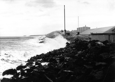
Photograph - Photograph - aerial view of grain silos, Portland, n.d
... Photograph - aerial view of grain silos, Portland...Black and white photograph of an aerial view of grain silos... photograph of an aerial view of grain silos Photograph Photograph ...Port of Portland Authority archivesFront: (no inscriptions) Back: P.H.T./ Print No. ... Neg. No 186/ Date taken .../ SUBJECT./ ... (Ink stamp with blue pen and pencil additions, centre)port of portland archives, aerial photography, portland harbour -
Glenelg Shire Council Cultural Collection
Photograph - Photograph - aerial view of Portland, 1960
... Photograph - aerial view of Portland... south. Photograph Photograph - aerial view of Portland ...Port of Portland Authority ArchivesBack: Aerial View South - July '60 -Top left, pencilport of portland archives, aerial photography, portland harbour -
Glenelg Shire Council Cultural Collection
Photograph - Photograph - aerial view of railway line between Heywood and Rennick, 03/05/1952
... Photograph - aerial view of railway line between Heywood... Photograph - aerial view of railway line between Heywood and Rennick ...From a series of photographs taken for Victorian Railways in 1952.Back: 'Heywood - Rennick 21394 - 19665 261m 42c ' - all black ink. Purple VR aerial survey stamp. '3 May 1952' - black stampvictorian railways, heywood, rennick, aerial photography -
Glenelg Shire Council Cultural Collection
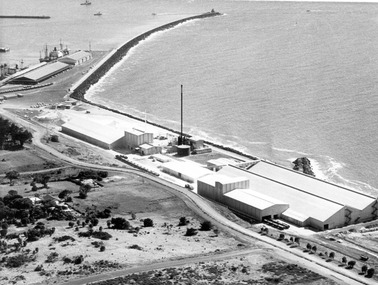
Photograph - Photograph - aerial view of Cresco factory, Portland, c. 1960
... Photograph - aerial view of Cresco factory, Portland...Black and white photograph of an aerial view of Cresco... and white photograph of an aerial view of Cresco factory. Photograph ...Port of Portland Authority archivesFront: (no inscriptions) Back: (no inscriptions)port of portland archives, aerial photography, cresco -
 Glenelg Shire Council Cultural Collection
Photograph - Photograph - aerial view of Cresco factory, Portland, c. 1960
... Photograph - aerial view of Cresco factory, Portland... breakwater. Photograph Photograph - aerial view of Cresco factory ...Port of Portland Authority archivesFront: (no inscriptions) Back: (no inscriptions)port of portland archives, cresco -
 Glenelg Shire Council Cultural Collection
Photograph - Photograph - Aerial view of Cresco/Pivot, Aerial view of Cresco/Pivot, c. 1960
... Photograph - Aerial view of Cresco/Pivot...Black and white photograph of an aerial view of a factory....: (no inscriptions) Black and white photograph of an aerial view of a factory ...Port of Portland Authority archivesFront: (no inscriptions) Back: (no inscriptions)port of portland -
 St Kilda Historical Society
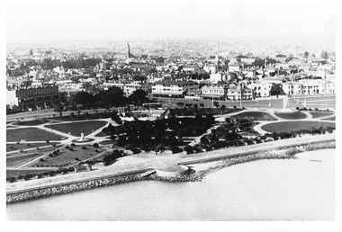
Photograph - Photograph - aerial view, 1920s
... Photograph - aerial view... and white, photograph arial original Photograph Photograph - aerial ...Aerial view of St Kilda from Port Phillip Bay, with Catani Gardens in the foregroundblack and white, photograph arial original catani gardens, fitzroy street -
 Glenelg Shire Council Cultural Collection
Photograph - Photograph - aerial view of Portland foreshore, 1970s
... Photograph - aerial view of Portland foreshore...Portland Foreshore harbour coastal photography Aerial Photo ...Aerial view of Portland and foreshore. Black and white photograph. Breakwater is on left, but part has only one domed building evident on far right.Front: (no inscriptions) Back: Twites Picture Framers, Carlton label.portland foreshore, harbour, coastal photography, aerial photo, portland -
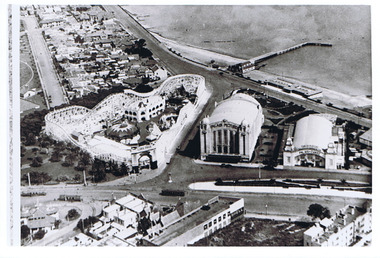 St Kilda Historical Society
Photograph - Photograph - aerial view, 1920s
... Photograph - aerial view... Photograph - aerial view ...Aerial view of Luna Park, Palais Pictures, Palais de Danse, St Kilda Pier late 1920sblack and white, arial photograph luna park, palais de danse, palais pictures, st kilda pier -
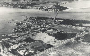 Phillip Island and District Historical Society Inc.
Photograph, San Remo & Phillip Island, 1940's
... Aerial photograph of Mainland and Phillip Island... construction Aerial photograph of Mainland and Phillip Island ...Aerial view of first Phillip Island Suspension Bridge completed in 1940 and opend by Hon. Albert Dunstan MLA, Premier of Victoria.Aerial photograph of Mainland and Phillip Island with connecting bridge from Newhaven, showing San Remo.local history, photographs, civil engineering, bridges, phillip island bridge, black & white photograph, jack jenner collection, phillip island bridges, public construction -
 Victoria Police Museum
Photograph (police car), Kodak
... Aerial photograph of Single Spinner Ford leaving Russell...; russell street Aerial photograph of Single Spinner Ford leaving ...Aerial photograph of Single Spinner Ford leaving Russell Street police garage, circa 1950police vehicles; transport branch; wireless patrol; motor police branch; motor traffic section; ford single spinner car; russell street -
 Bendigo Historical Society Inc.
Photograph - WES HARRY COLLECTION: AERIAL VIEW OF BENDIGO CBD, 1966
... Aerial photograph of the Bendigo CBD. On the reverse... of Victoria Aerial photograph of the Bendigo CBD. On the reverse ...Aerial photograph of the Bendigo CBD. On the reverse is written : 'City of Bendigo 1966, State aerial Surveyplace, aerial view of bendigo, cbd, bendigo cbd, aerial survey of victoria -
 National Vietnam Veterans Museum (NVVM)
Photograph, 161 (INDEP) Reece FLT Lines
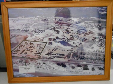
... Aerial Photograph of 161 (INDEP) Recce FLT lines at Back... Reconnaissance Flight Vung Tau Aerial Photograph of 161 (INDEP) Recce FLT ...Aerial Photograph of 161 (INDEP) Recce FLT lines at Back Beach Vung Tau 1966photograph, 161 reconnaissance flight, vung tau -
Whitehorse Historical Society Inc.
Map, Boronia Road, Vermont, 1970
... Enlargement of aerial photograph of Boronia Road, Vermont... Cosgrove Street Vermont Mawson Court Vermont Aerial photographs ...Enlargement of aerial photograph of Boronia Road, Vermont. State Aerial Survey 1970 Run 37Enlargement of aerial photograph of Boronia Road, Vermont. State Aerial Survey 1970 Run 37Enlargement of aerial photograph of Boronia Road, Vermont. State Aerial Survey 1970 Run 37boronia road, vermont, lusk drive, vermont, morack road, vermont south, allison court, vermont, trinian street, vermont, cosgrove street, vermont, mawson court, vermont, aerial photographs -
Whitehorse Historical Society Inc.
Map, Boronia Road, Vermont, 1970
... Enlargement of Aerial photograph of Boronia Road Vermont... Vermont Aerial photographs Enlargement of Aerial photograph ...Enlargement of Aerial photograph of Boronia Road Vermont, State Aerial Survey, 1970. Run 37Enlargement of Aerial photograph of Boronia Road Vermont, State Aerial Survey, 1970. Run 37Enlargement of Aerial photograph of Boronia Road Vermont, State Aerial Survey, 1970. Run 37boronia road, vermont, gallus close, vermont, moore road, vermont, carlinga drive, vermont, beleura avenue, vermont, olinda crescent, vermont, penllyne avenue, vermont, holyrood drive, vermont, aerial photographs -
 Rutherglen Historical Society
Photograph - Aerial Images, c2000
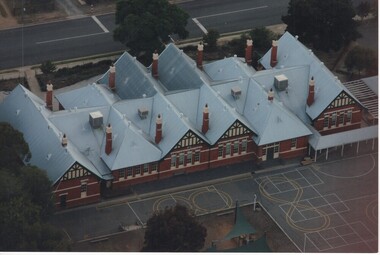
... Colour aerial photograph of Rutherglen Primary School... state school school buildings Colour aerial photograph ...Photograph was probably taken sometime before 2007, as another photo in this series does not show the "Big Red Shed" behind the school. That building is shown on Google Street View shots taken in 2007. Rutherglen Common School No. 522, which is now the Common School Museum, would be to the left of the current school in the photo.Colour aerial photograph of Rutherglen Primary School No. 522, showing the rear of the building and its rooftop.rutherglen primary school, rutherglen state school, school buildings -
 Bendigo Historical Society Inc.
Photograph - BENDIGO ORDINANCE FACTORY COLLECTION: AERIAL VIEW OF FACTORY COMPOUND
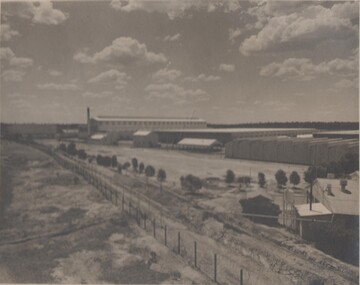
... Aerial photograph of the development of the ordinace... Aerial photograph of the development of the ordinace factory ...Aerial photograph of the development of the ordinace factory , taaken in the 1950s Black & white photo, large format -
Port Fairy Historical Society Museum and Archives
Photograph
... Black and white aerial photograph of Port Fairy looking... aerial railway river town Black and white aerial photograph ...aerial view over Port Fairy looking across the river at the railway line and butter factoryBlack and white aerial photograph of Port Fairy looking across the Moyne river and railway stationaerial, railway, river, town -
 Wodonga & District Historical Society Inc
Photograph - W. G. Page Saleyards, Wodonga, c1980
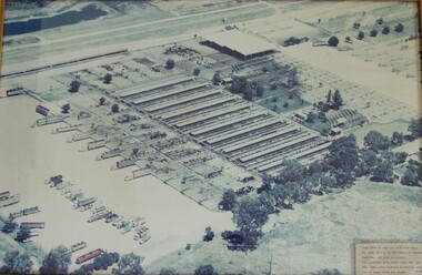
... An aerial photograph of the W. G. Page Saleyards in Wodonga... for 25 years until his death". An aerial photograph of the W. G ...William George Page was Shire and City Engineer in Wodonga from 1965 until 1989. When he arrived the Shire of Wodonga had a population of 17,000 people. In 1966 Wodonga was selected as a city for special growth assistance. In 1972 Bill Page presented a new Town Plan to the Wodonga Council. Over the ensuing years he dedicated himself to bring this plan to fruition. He often had to argue and campaign with the Albury-Wodonga Corporation to push for the interests of development in Wodonga. This included winning a planning appeal to allow the saleyards to be relocated to Bandiana on the outskirts of Wodonga. Bill Page retired on health grounds in July 1989. The Council honoured him with a farewell dinner and renamed the saleyards at Bandiana the W.G. Page Saleyards in his honour.The Mayor , Cr Valentina Gillard, said "Every development in Wodonga in the past 24 years has a bit of Bill Page in it". William Page died 3 months later at 58 years old.This image depicts an important centre in the development and support of the livestock industry around Wodonga.An aerial photograph of the W. G. Page Saleyards in Wodonga. It has been mounted in a wooden frame.On a sign attached to the photo frame: "This photo of the W.G. Page Saleyards has been donated to the people of Wodonga from Mrs Pat Page and Family. The saleyards were named after the late Bill Page, City Engineer of Wodonga Council for 25 years until his death".w. g. page saleyards, wodonga saleyards, william george page -
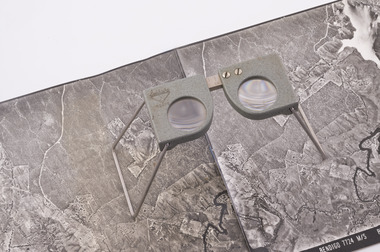 Forests Commission Retired Personnel Association (FCRPA)
Pocket Stereoscope
... Small pocket stereoscope to interprete aerial photographs... and overlapping aerial photos as a single three-dimensional image ...This pocket stereoscope was used to view a pair of separate and overlapping aerial photos as a single three-dimensional image. It was small and could be easily used in the field. Larger, mirror stereoscope were also available in some offices. The aerial images were used to map forest types, timber stands, new roads and tracks, firebreaks, boundaries of timber harvesting, plantations, bushfires, insect and disease attack and so on In 1928, the Forests Commission undertook its first major aerial photography project over 15,000 acres of forest which is said to be the first of its kind in Australia. During the Second World War, large areas of Victoria were photographed by RAAF and used to produce orthophoto maps. By 1945 aerial photography of 13,000 square miles (3.4 M ha) was completed, including much of the inaccessible eastern forests. The Forests Commission started developing its own small format photography in the early 1970s. Simple, cheap and rapid methods of obtaining photographs using 70mm and 35mm cameras were developed Small pocket stereoscope to interprete aerial photographs in the field Adjustable lenses on foldaway wire legsSokkisha Tokyoforest measurement, surveying, forests commission victoria (fcv) -
University of Melbourne, Burnley Campus Archives
Photograph, Aerial View of Burnley Campus, 1980s?
... 6 sheets of overlapping aerial photographs of section...Burnley Horticultural College aerial photographs nursery ...6 sheets of overlapping aerial photographs of section of Burnley Campus: Nursery, Agrostrology and railway line. burnley horticultural college, aerial photographs, nursery, agrostology, railway line -
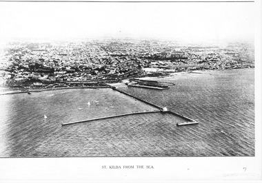 St Kilda Historical Society
Photograph - Photograph Arial
... aerial photograph... Carlisle Street St Kilda melbourne aerial photograph St Kilda from ...aerial photographPhotograph black and white arial Copy of original. View of water, yachts in foreground and pier with Catani gardenes midground and rest of St kilda in distance.St Kilda from the Sea -
Phillip Island and District Historical Society Inc.
Photograph
... Black & White Aerial Photograph showing the two bridges... Aerial Photograph showing the two bridges between Newhaven ...Photograph from The Herald and donated by Jack MorrisonBlack & White Aerial Photograph showing the two bridges between Newhaven and San Remo, the old and the new.local history, photography, photographs, slides, film, civil engineering, bridges, history of the phillip island bridge, black & white photograph, phillip island bridge -
Phillip Island and District Historical Society Inc.
Newspaper clippings, 23/05/1973
... Aerial photograph of Churchill Island and article... Aerial photograph of Churchill Island and article on history ...Article on prospective sale of Churchill & Elizabeth Islands. Short history of Islands and photographs of Churchill Island and Cairn to commemorate pioneer wheat growing 1801.Aerial photograph of Churchill Island and article on history of Churchill Island and Elizabeth Island and prospective sale of the Islands.local history, documents, newspapers, newspaper clipping, churchill island, elizabeth island, black & white newspaper clipping, churchill island, first wheat crop in australia, lt grant -
Glenelg Shire Council Cultural Collection
Photograph - Photograph - Portland Smelter, c. 1980
... Framed aerial photograph of Portland Smelter taken... in offices at Smelter Portland Smelter Framed aerial photograph ...Previously displayed in offices at SmelterFramed aerial photograph of Portland Smelter taken in the 1980's. Image shows the town of Portland in the background.portland smelter -
Glenelg Shire Council Cultural Collection
Photograph - Photograph - Portland Smelter, c. 1980
... Framed aerial photograph of Portland smelter taken... in Offices at the Smelter. Portland Smelter Framed aerial photograph ...Previously displayed in Offices at the Smelter.Framed aerial photograph of Portland smelter taken in the 1980's. Image show's Lawrence Rocks in the background.portland smelter -
Glenelg Shire Council Cultural Collection
Photograph - Photograph -Reclamation and Canal work, 1959
... Black and white aerial photograph showing land reclamation..., pencil. Black and white aerial photograph showing land ...Port of Portland Authority ArchivesBack: November 1959 - Top right, black biro. Reclamation and canal work at southern end of botanic gardens - bottom left, pencil.port of portland archives, land reclamation, canal -
Glenelg Shire Council Cultural Collection
Photograph - Photograph - land reclamation, 1959
... Black and white aerial photograph showing land reclamation... November 1959 - typed. Black and white aerial photograph showing ...Port of Portland Authority ArchivesFront: Canal and Reclamation. Aerial view west November 1959 - typed.port of portland archives, land reclamation, canal, botanic gardens -
Glenelg Shire Council Cultural Collection
Photograph - Photograph - K. S. Anderson Wharf, n.d
... and surrounds. Aerial photograph taken from North East.... and surrounds. Aerial photograph taken from North East. Photograph ...Port of Portland Authorityport of portland archives, aerial photography, portland harbour -
Whitehorse Historical Society Inc.
Map, Boronia Road, Canterbury Road intersection, c1970
... Enlarged aerial photograph of the intersection... Vermont Aerial photographs Enlarged aerial photograph ...Enlarged aerial photograph of the intersection of Canterbury and Boronia Roads. State Aerial Survey, Melbourne 1970 project.Enlarged aerial photograph of the intersection of Canterbury and Boronia Roads. State Aerial Survey, Melbourne 1970 project.Enlarged aerial photograph of the intersection of Canterbury and Boronia Roads. State Aerial Survey, Melbourne 1970 project.boronia road, vermont, canterbury road, vermont, mitcham road, vermont, frances avenue, vermont, nurlendi road, vermont, beaumont street, vermont, kingsclere street, vermont, webb court, vermont, aerial photographs