Showing 751 items matching "chartism"
-
 Flagstaff Hill Maritime Museum and Village
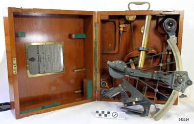
Instrument - Navigational Sextant, 1882-1890
A sextant is an astronomical instrument used to determine latitude and longitude at sea by measuring angular distances, especially the altitudes of the sun, moon, and stars. It is a doubly reflecting navigation instrument and used mainly by sailors to measure the angular distance between two visible objects. The name comes from the Latin sextans, or “sixth part of a unit,” because the sextant’s arc can be 60° or 120° of a circle depending on the model used. The primary use was to measure the angle between an astronomical object and the horizon for the purposes of celestial navigation. The estimation of this angle is known as sighting or shooting the object, or taking a sight. This angle and the time when it was measured is used in order to determine Greenwich Mean Time and hence longitude. Sighting the height of a landmark on land can also give a measure of distance from that object. History: The development of the sextant was as an improvement over the octant, an instrument designed to measure one's latitude. The octant was first implemented around 1731-present but can only measure angles up to 45°. As larger angles were needed to allow the measurement of lunar objects - moon, stars and the sun - at higher angles, the octant was superseded by the sextant. The sextant is a similar instrument but better made and allows larger angles from 60° to 120°. This improvement allows distances to be accurately calculated thereby giving longitude when used with a chronometer. The sextant was derived from the octant in 1757, eventually making all previous instruments used for navigational positioning obsolete. The sextant had been attributed to by John Hadley (1682–1744) and Thomas Godfrey (1704–1749), but reference to the sextant was also found later in the unpublished writings of Isaac Newton (1643–1727). Earlier links can be found to Bartholomew Gosnold (1571–1607) indicating that the use of a sextant for nautical navigation predates Hadley's implementation. In 1922, the sextant was modified for aeronautical navigation by Portuguese navigator and naval officer Gago Coutinho. It should be noted that the octant and quadrant are in the same family as they were, and all are, regarded as sextants. The sextant is representative of it's type and although not fully complete it demonstrates how 18th,19th and 20th century mariners determined their latitude and longitudinal to determine their position on a chart, allowing them to navigate there way across the world's oceans. It also demonstrates the skill and workmanship of the early instrument makers that operated scientific instrument businesses from London and other areas of England to provide most of the navigational instrumentation used by commercial and military navies of the time.Sextant with square, fitted box of polished wood, "Hezzanith" brand. Box contains many parts for the sextants use. On certificate "Heath & Co, London. Sextant Number Y 822". Catch on lid "DEFIANT LEVER" and "PATENT NUMBER 187.10". Maker's certificate is attached to the inside of the box.flagstaff hill, warrnambool, shipwrecked-coast, flagstaff-hill, flagstaff-hill-maritime-museum, maritime-museum, shipwreck-coast, flagstaff-hill-maritime-village, sextant box, sextant, hezzanith, heath & co, navigational instrument, george wilson heath, astronomical instrument, instrument manufacturers, scientific instrument, navigation, celestial navigation, octant, quadrant, lunar navigation -
 Orbost & District Historical Society
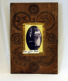
framed photograph, 1923
The frame was hand carved by Cecil Rice and given to his aunt Mrs Marion Gargan. Cecil Rice ( 1912 - 1985) was the son of Walter Cecil Rice and Ellen Theresa Gargan.This item is a pictorial record of a 1920s wedding. Wedding dresses are a useful way to chart changing fashions. The Gargans were early settlers in the Orbost district.A small black / white wedding photograph of a seated man with a woman standing beside him. He is wearing a dark suit, white bow tie and is holding a pair of white gloves in one hand. She is wearing a dress which finishes above the ankles. She has a veil which is "cloche" style and is holding a large bunch of flowers.The photograph has a yellow frame and is mounted on gold card inside an ornately carved wooden frame.on front - Marion & Tom Gargan 1923gargan-thomas gargan-marion rice-walter wedding-photography -
 Bendigo Military Museum
Map - EASTER NEW GUINEA NAVIGATION CHART, RAAF, Aug 1943
From the collection of "Maxwell Lennox Matheson" No.418447 RAAF. Enlisted 22/5/1942 Aged 19. Discharged 19/2/1948 - Rank FLTLT.This map is in colour. It is made of a stiff paper and has a map printed on both sides. Side1 - scale 1:2,315,000. 31.72 Nautical miles = 1 inch. It shows Eastern half of New Guinea. It also shows New Britain and New Ireland. Manus Island is at the top. Side 2 - Scale 1:1,000,000 - this shows Manus Island on right side, top of New Guinea at bottom edge (Wewak) and some other little islands. The map on side 1 has numerous navigation tracks and calculations in pencil. i.e. LAE, KOKODA, PORT MORESBY.ww2, raaf, new guinea -
 Bendigo Military Museum
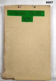
Document - Army Survey Regiment Manning Chart 1976, 1976
This document contains detailed photocopies of reports of Army Survey Regiment’s staff manning from December 1975 to August 1976. Each monthly report provided to Directorate of Survey covered the allocation of staff to Regimental Headquarters and its four sub units comprising Headquarters, Air Survey (Topographic), Cartographic and Lithographic Squadrons. Each Squadron’s troop or section structure was represented by a wire diagram with soldiers and/or civilians names assigned to rank based established positions. A detailed table at the end of each report sumarised Army Survey Regiment’s posted strength by employment category and rank.Manilla cardboard folder containing 83 photocopied pages of staff posted to the Army Survey Regiment. Pages are fixed to the folder by a metal fastener. The title of the folder is written in black ink on a green tape background.royal australian survey corps, rasvy, army survey regiment, army svy regt, asr, fortuna -
 Bendigo Military Museum
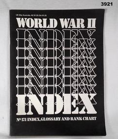
Magazine - MAGAZINE COLLECTION, Orbis Publishing Ltd, World War II Index, Glossary and Rank Chart, 1981
Also see Reg No 3909.6 Magazine Collection Volumes 1 - 6 in binders Reg No 3910.56 Magazine Collection Volumes 7 - 10 not in binders Reg No 3919.15 Magazine Collection The Armed Forces Part No 141 - Part No 155 Reg No 3920 Magazine Collection The Post War Conflicts Part No 156 - Part No 170No 171. Paper cover with white print on black background. Cut, plain, white, pages. Illustrated inside back cover with black / white photo of a German Infantryman. 52 pages.magazine, collection, glossary, rank -
 Federation University Historical Collection
Book, Dianne Campbell, Anglo-Irish Lawyers in Post-Goldrush Ballarat, 09/2002
Masters thesis bound in marron hard coverlawyers, legal, henry cuthbert, townsend mcdermott, milfred mcdermott, joseph dunne, charles cuthbert, j. dunne, robert le poer trench, adam loftus lynn, robert walsh, beaufort house, genealogical charts, mary cuthbert, william a'beckett, butler aspinall, redmond barry, samuel bindon, daniel brophy, alfred carr, george clenninning, thomas cope, john leslie foster, richard hobson, charles hotham, john basson humffray, richard ireland, archibald michie, robert molesworth, richard o'cock, bryen o'loghlen, william stawell, dianne campbell goldfields lawyers collection, anglo-irish, irish -
Federation University Historical Collection
Book - Book - Scrapbook, Ballarat School of MInes: Scrapbook of Newspaper Cuttings, Book 41, October 1989 to December 1989
Collection of newspaper articles related to Ballarat School Of Mines.They cover activities and advertisements for staff. The papers concerned are The Courier, Ballarat, The Australian, The Age over the period of 12 October 1989 to 29 December 1989.Book with yellow cover, front, spiral bound. teaching positions advertised, pre-employment courses, courses available, enrolment for smb courses, photographs ballarat life, edan bradley, sarah bolster, special entry scheme, access program for women, anthony wonish silver medal winner, kathryn wilson first r j young scholarship, promoting opportunities at smb, ann mccaffrey, smb open day, training structure charts, women speak on small business, radiotherapy machine needed in ballarat, leesa arnott hairdressing apprentice, aim for 500 apprentices, cuts to performing arts?, smb juggles plan for cost cutting, smb advanced certificate in ceramics, david addy winner of edgar bartrop scholarship, literacy volunteer graduates, course offers youth hope of work, brickies of the future, adult literacy program cuts, advanced ceramics exhibition, students organise deb ball, government education bill, library named after jack barker, julie oldham wins computer service award, wendy caple and allan lion horticulture students, prejudice attitudes -
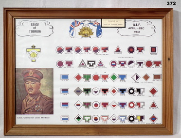 Bendigo Military Museum
Memorabilia - COLOUR PATCH CHART FRAMED, Rats of Tobruk Association, Post 1945
Information board showing colour patches & units that were in the Siege of Tobruk. There is a print portrait of LT GEN SIR LESLIE MORSHEAD at bottom left. Top centre shows Rising Sun badge surrounded by Union Jack & Australian flag. There is a Rats of Tobruk Association badge on left side.Siege of Tobruk AIF April - Dec 1941.colour patches, tobruk ww2 -
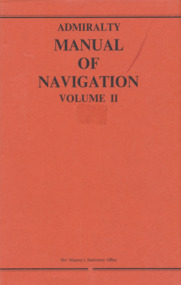 Mission to Seafarers Victoria
Book, Her Majesty's Stationery Office, Admiralty Manual of Navigation Vol.2, 1973
This volume of the Admiralty Manual of Navigation describes off-shore navigation - the safe conduct of a ship across the open sea where, in general, hearings of objects on land cannot be obtained except by means of radio waves (i.e. using radio fixing aids). The first chapters are mainly concerned with distances, courses, tracks and charts; then various methods of obtaining position lines and positions from astronomical observations are explained, including a rapid. method in the last chapter. The volume also contains an outline of meteorrology and weather forecasting.329 pages, illustrated, navy blue linen cover and red paper dust jacket.non-fictionThis volume of the Admiralty Manual of Navigation describes off-shore navigation - the safe conduct of a ship across the open sea where, in general, hearings of objects on land cannot be obtained except by means of radio waves (i.e. using radio fixing aids). The first chapters are mainly concerned with distances, courses, tracks and charts; then various methods of obtaining position lines and positions from astronomical observations are explained, including a rapid. method in the last chapter. The volume also contains an outline of meteorrology and weather forecasting.howard timbury, first fleet fellowship victoria, interest group, navigation, education -
![Poster, The Age et al, Time Chart of Australian History [to 1980], 1980c](/media/collectors/4f729f5697f83e03086015b8/items/5cbeb83e21ea680ef0fa5549/item-media/5cbeb8f821ea680ef0fb5238/item-fit-380x285.jpg) Greensborough Historical Society
Greensborough Historical SocietyPoster, The Age et al, Time Chart of Australian History [to 1980], 1980c
A timeline of Australian history from the first Australians, European exploration and discovery to 1980. Prepared by Ila Brown for The Age. Includes timeline, maps and photographsSet of 4 laminated posters, printed in colour on one side.australia history, australia exploration -
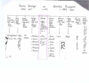
 Greensborough Historical Society
Genealogical chart, Descendants of Henry Bartlet (Barl) Splatt (1863-1937), 07/07/1792o
This family tree gives details of five generations of descendants of Henry Bartlett (Barl) Splatt. Compiled by Val Wilson (nee Rolfs).14 pages. In black spiral folder with clear cover.henry bartlett splatt, barl splatt, val wilson(nee rolfs), poulter, chapman family, splatt family -
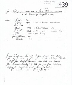 Greensborough Historical Society
Genealogical chart, James Chapman/Susan Palmer, 1805o
This list is of James Chapman and Susan Palmers immediate family.This couple were pioneers of Greensborough.A double sided document listing a family tree.Niljames chapman, susan palmer, greensborough, cowlinge suffolk, susan haylock, henry splatt, george poulter, william poulter -
 Greensborough Historical Society
Genealogical chart, Heritage Family, 1920_
Gives details of a family group that lived in Alexandra Street Greensborough from 1920 to 1980's.A 1 page photocopy of a hand written family tree.Nilheritage family, lonsdale family, 1920, alexandra st -
Glenelg Shire Council Cultural Collection
Document - Document - Conversion Chart, n.d
Port of Portland Authority Archivesport of portland archives -
Glenelg Shire Council Cultural Collection
Document - Document - Chart specifications Osgood model 1000, n.d
Port of Portland Authority Archivesport of portland archives -
4th/19th Prince of Wales's Light Horse Regiment Unit History Room
Booklet, George Allen & Unwin, The Observers Handbook on Maps Charts and Projections, Sep 1941
Not significant to collection. Available for transfer to more appropriate collection.Booklet written for observers and pilots of the RAF and RAFVR to help them in preparing for their examinations.maps, charts, raf, observers -
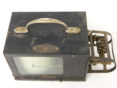 Kiewa Valley Historical Society
Barometer Anoroid, circa mid to late 1900's
This barometer was part the hydrology and forestry groups working within the SEC Vic Hydro Scheme from the initial appraisal review long before any construction began in the 1940's. The river flows and rainfall patterns had to be established before any construction of holding dams or tunneling could commence. This barometer is very relevant to the Kiewa Valley history because it presents the high degree of professional and technical information required at the time before implementing the "Scheme" upon the virgin alpine region and its effects upon the "natural" flows of the rivers within the Kiewa Valley. Time since the start of the project has verified the use of instruments such as this barometer and the information gained from its use that the success of any large impact upon a sensitive environment requires a thorough and systematic study before implementation. Weather records were kept of temperature, wet-bulb temperature, wind direction, speed and barometric pressures. To record barometric pressure a meter was devised with a clockwork mechanism which took one week to do a revolution. A chart was fitted to a drum and had an ink pen shaped like a little shovel. The shovel was filled with ink and was checked daily. To calibrate the barometer it was sent to the Melbourne General Post Office to be compared against the one there (at sea level). After calibration it was sent back to the Bogong Camp.On plaque on top side."NEGRETTI & ZAMBRA" underneath this and in smaller print "TRADE MARK" below this "LONDON" On the bottom and in small print "HOBART DUFFPty Ltd COLLINS HOUSE MELBOURNE C1"kiewa hydro electricity scheme, victorian state electricity commission, transformers, resistors, barometers -
 Kiewa Valley Historical Society
Map / Chart, Vegetation Map & Guide to Alpine Flora: Pretty Valley, 1982
This poster shows Pretty Valley is on the Victorian High Plains where the State Electricity Commission of Victoria worked on the Kiewa Hydro Scheme. Also cattle have grazed in the area over the years. This map is of interest to compare the flora in the area with times prior to 1982 and after 1982.This poster has historical and research value as it shows the flora in the pretty valley area therefore making it significant for people interested in plants. Also for those who would like to compare what plants are still in this area after 1982 and if the cattle grazing, climate change, of bush fires have had on the environment. Thus this poster also has good interpretive capacity of these reasons. Laminated double sided vegetation map and photographic guide to Alpine flora of the Pretty Valley areapretty valley. bogong. vegetation. plants. flowers. alpine. victorian high plains. cattle grazing. s.e.c.v. -
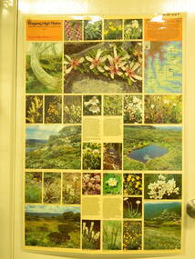
 Kiewa Valley Historical Society
Map / Chart, Vegetation Map & Guide to Alpine Flora: Hotham, 1982
This poster shows Mt Hotham is on the Victorian High Plains. This poster and map enables the comparison to be made of flora in other areas of the Victorian High Plains e.g.. which was previously known as the Bogong High Plains. This poster has historical and research value as it shows the flora in Mt Hotham area therefore making it significant for people interested in plants. Also for those who would like to compare what plants are still in this area after 1982 and if the cattle grazing, climate change, of bush fires have had on the environment. Thus this poster also has good interpretive capacity of these reasons.Laminated double sided vegetation map and photographic guide to Alpine flora of the Hotham area.hotham. vegetation. plants. flowers. alpine. high plains of victoria. -
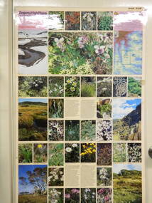
 Kiewa Valley Historical Society
Map / Chart, Vegetation Map & Guide to Alpine Flora: Rocky Valley, 1982
This poster is of Rocky Valley is on the Victorian High Plains where the State Electricity Commission of Victoria worked on the Kiewa Hydro Electric Scheme and also where cattlemen brought their cattle up during summer at various times. Its significance is due to it shows the flora of the area after the Kiewa Hydro Electric Scheme Rocky Valley damn has been build and therefore is a valuable for comparison to see what plants are there now after this information on this poster was complied. Historic: Comparison of the flora at Rocky Valley with other areas on the Victorian High Plains and with Rocky Valley before and after the Kiewa Hydro Scheme and / or grazing there. Is therefore research significance and interpretive capacity due to this compatibility value.Laminated double sided vegetation map and guide to the Alpine flora of the Rocky Valley area, with photographs of plants and vegetation.rocky valley. alpine. flora. vegetation. plants. s.e.c.v.. cattlemen. victorian high plains. -
 Kiewa Valley Historical Society
Papers - Newspaper Obituary Harry Vyner and Family History Chart
The obituary is of Harry Vyner, who came to work for the SECV on the KHES in 1938This is an example of one man's life and how he came to live in the Kiewa Valley and his contribution to the development of Mount Beauty as a thriving community.A4 Sheet with family tree details of Harry Vyner / McKendrick families Newspaper cutting re Obituary of Harry Vyner dated December 1979harry vyner, country roads board, high plains road -
 Kiewa Valley Historical Society
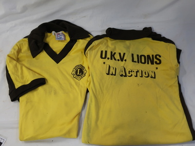
T-Shirt - Upper Kiewa Valley Lions
Lions Club was first formed in 1947 in Victoria. It is a Services club for the CommunityThe Upper Kiewa Valley Lions Club was charted in 1964 and continues today (2024)Yellow T-shirts with brown collars and cuffs and at the waist.On the back printed in brown "U.K.V. Lions / In Action" On the front is the Lions Club logoupper kiewa valley lions club -
 Flagstaff Hill Maritime Museum and Village
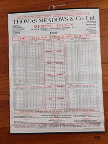
Poster - Shipping Timetable, Barclay and Fry Ltd. London, Time Table of Australian Sailings, circa 1939
"Freight forwarding" is the arranging of the shipping of goods from their point of origin to their final destination. Freight Forwarders worked as an intermediary between companies that needed to ship products and the shipping and transportation firms that could ensure delivery. A key element of "freight forwarding" was the advice and professional handling of documentation and customs requirements provided. Early "freight forwarders" tended to be innkeepers who forwarded on the luggage of their hotel guests. One of the first "freight forwarding" companies was established by Thomas Meadows in 1836 which made it one of the earliest freight companies in Europe. More reliable rail and steamships were beginning to be used to transport goods and this created a demand for the new "freight forwarding" industry. The combination of railroads and steamships became very important in the late 19th and early 20th century. International shipments became common and freight forwarding that could handle their complexity became an integral part of the manufacturing and shipping landscape. Thomas Meadows & Company Ltd moved to offices in Milk Street, London in 1854 (where they remained until 1969 when they moved out of the city to Leytonstone) and continued in the freight business until 1987 when the company was acquired by Rockwell International Freight. The growth of Thomas Meadows & Company Ltd coincided with the growth and development of the colony of Victoria with an increasing need for the transporting of large numbers of people as well as important goods required by the growing colony - furniture, spirits, food, clothing, agricultural implements, household items etc. In the late 1840's only two or three overseas ships a month visited Melbourne but by late 1852 (after gold was discovered) more than a dozen ships arrived each week. By 1939, Thomas Meadows & Co. Ltd. had offices in Canada, U.S.A., New Zealand, France, Belgium and in Flinders Street Melbourne. This poster was sold by "Smarts Authorised Newsagency" in 1988 in Warrnambool - a business that had been owned by Neil and Shirley Smart at 168 Timor Street, Warrnambool since 1976. Previously it had been "Reed's Newsagency and Book Shop" (a local business established by William Reed circa 1912 and known as "William Reed Bookseller and Stationer"). The original owners, Reed's Newsagency and Bookshop were operating the shop in 1939 which suggests the poster may have been on display (for the information of their customers) in their shop at that time. This poster is significant through its association with Thomas Meadows and Co. Ltd. who is considered to be the founder of the "freight forwarding" industry in the early 19th century. It is an example of advertising used by shipping agents in the mid-19th to early 20th centuries. Its information includes the addresses of the firm's different offices in the U.K. and abroad, ships, shipping lines and ports used and the timetable the vessels were likely to follow. It is also significant through its association with a well known and long standing local Warrnambool business.A 1939 Timetable of "Australian Sailings" produced by the shipping agents Thomas Meadows and Co Ltd. It lists all their ships (plus dates and ports) sailing from the UK to Australia as well as the addresses of their offices in other cities in the U.K., Canada, U.S.A., Australia, New Zealand, France and Belgium. It has three vertical columns depicting (from left to right) January to June sailings, a simple 1939 calendar and their July to December 1939 sailings. The poster is attached on the top and bottom to two thin black metal strips. The top strip has a metal ring with a hole. A stamped label on the back of the poster has the name, telephone number and address of Smarts newsagency plus the date.Front of poster - "FORWARDING AGENTS. INSURANCE BROKERS.PASSENGER AGENTS.CARTAGE CONTRACTORS / MOTOR CAR AND MACHINERY PACKERS.FURNITURE AND GENERALEXPORT PACKERS" "THOMAS MEADOWS & CO Ltd." "ESTABLISHED OVER 100 YEARS" "SHIPPING AGENTS / 35 MILK STREET, CHEAPSIDE, LONDON, E.C.2" "PACKING WAREHOUSES IN LONDON & MANCHESTER" "1939" "TIME TABLE OF AUSTRALIAN SAILINGS" "JANUARY TO JUNE, 1939/ FROM LONDON" "JULY TO DECEMBER, 1939 / FROM LONDON" "HAVE YOUR SMALL PACKAGES SENT BY OUR SPECIAL "SMALLS" SERVICE AT LOWER RATES/RATES TO PORT ONLY OR INCLUDING DELIVERY THROUGHOUT AUSTRALIA" "INSURANCE AGAINST ALL RISKS EFFECTED WITH CLAIMS PAYABLE DESTINATION" "ROUTE YOUR SHIPMENTS VIA THOMAS MEADOWS & CO LTD. FOR PROMPTNESS AND ECONOMY" Stamp on back of poster - "SMART'S AUTHORISED NEWSAGENCY' "168 Timor Street, Warrnambool 3280" "Telephone: (055) 62 2092" "12 DEC 1988" Sticker at bottom - "51"flagstaff hill maritime museum and village, great ocean road, shipping, shipping agents, freight forwarding, freight, shipping time table, thomas meadows & co. ltd., thomas meadows shipping agent, shipping and forwarding agent, smart's newsagency, warrnambool, warrnambool newsagency, chart, poster, smart's authorised newsagency, neil and shirley smart, william reed, reed's newsagency and bookshop -
 Federation University Historical Collection
Documents - Reports, Unidentified Large Cat Sightings in Maryborough
The folder or correspondence is the result of a Freedom of Informaition request made to the Department of Primary Industries in 2011. The folder was collected for research being conducted by David Waldron. John Higgins, managing editor of the Maryborough Advertiser was interested in sightings of what some suggested to be a puma or mountain lion in Central Victoria. A number of A4 printouts relating to large cat sightings in the Maryborough (Vic) area, many reported by the Marlborough Advertiser. The large cat referred to is often referred to as a Puma or Mountain Lion. (.7) Profile of Central Victorian Cat Australian Animal Folklore Collectionaustralian animal folklore collection, cat, ferral cat, puma, mountain lion, maryborough, maryborough victoria, ds saunders, bryan walters, bernie mall, peter chapple. graham george, australian cougar, felid, pamela parker, alan foskett, daisy hill, panther, john dix, ray elliott, dennis wiley, police sightings, graham hunt, brian douglas, stuart mill, graeme grant, a. venes, avoca, julie hobbs, greg gallagher, taltarni, moonambel, fred beach, majorca, michael rayner, chateau remy, john robb, wayne irvine, brian anderson, peter davies, talbot, joyce davies, tom davies, len farthing, barry rinaldi, edward stone, brian stone, judith tranter, alan poole, shane long, jim smith, lloyd forge, carisbrook, murray henderson, doug grose, john higgins, footprint cast, australian dasyurids, felis concolor, lioness, lion, shane long, wareek, koo-jar hill, american troops, betley cat, daisy hill cat, phelan road cat, amherst cat, john higgin, angus reynolds, betley tiger, tim clark, walters cougar catcher, identification chart, david towler, bob carr, rare fauna research society, lancefield cat, bernie mace, robert pattison, bryan de lacy, romsey, murray henderson, brian collinson, neil grummett, grummett, kenneth lamont, lamont, foskett, hobbs, rinaldi, poole, forge, henderson, grant, elliott, anderson, stone, irvine, douglas, stewart, long, mythical, myth, folklore, australian mythical animals collection, david waldron, land protection, d.s. saunders, judith henke, ravenswood, wedderburn, feral cat, laanecoorie, shellbourne, barru rinaldi, lan poole, dorothy smith, amherst cemetery, graham grant, maryborough advertiser, central victorian cat, st arnaud, kyneton, shane one wareek, lack of fossil evidence, koo-jat hill, cougar hill, plaster casts, lummis, goldsborough, ian lummis, hamilton, swan hill, wodonga -
Federation University Historical Collection
Poster, Federation University: Our History, 2019, 2019
Federation University Australia was established on 1 January 2014. Formerly known as the University of Ballarat, its enabling legislation was the University of Ballarat Amendment (Federation University Australia) Act 2013. Although formally created as a University in 1994, the University of Ballarat has a lineage back to 1870 with the establishment of the School of Mines Ballarat, making it the third institution of higher learning to be established in Australia and the first to be established in regional Australia. On 1 January 1994, Ballarat University College became the University of Ballarat and in 1998 the University merged with three TAFE Institutes to become a dual sector institution with multiple campuses. On 1 January 2014, the University of Ballarat amalgamated with the Monash University Gippsland Campus to form Federation University Australia. The Gippsland Campus also had a long lineage dating back to 1928 with the establishment of the Yallourn Technical School which became a predecessor institution to the Gippsland College of Advanced Education formed in 1968. In 1990, it was renamed the Monash University College and in 1993 became the Gippsland Campus of Monash University. In 2016, Federation University Australia announced plans to take possession, over a two-year period, of Monash’s Berwick Campus in the south-east corridor of Melbourne. Federation University Australia, or FedUni, is headquartered in Ballarat and offers programs in Higher Education and Vocational Education and Training to regional Victoria and beyond. The University’s commitment to educational and social equity, teaching excellence, research distinction, environmental sustainability and regional capacity building has enabled it to develop in a way that draws on its proud heritage to inform its future. Its regional character sets a framework for the University’s priorities but does not constrain it from serving wider community interests, nationally and internationally. The name Federation University Australia was chosen to convey the scope and capacity of an expanded regional university with a federated network of campuses.White, blue, grey and gold poster outlining the establishment date of each organisation and dates of name changes at Federation University Australia as of 2019. timeline, ballarat school of mines, ballarat junior technical school, ararat technical school, stawell school of design, stawell technical school, stawell junior technical school, wimmera institute of tafe, horsham technical school, ballarat base hospital school of nursing, ballarat teachers' college, ballarat school of industries, ballarat technical school, ballarat institute of advanced education, ballarat school of mines and industries, ballarat college of advanced education, yallourn technical school, yallourn technical college, gippsland institute of advanced education, horsham working men's college, ballarat university college, university of ballarat, monash university college, monash university gippsland, federation university australia, state college of victoria ballarat, chart, university of ballarat establishment, ballarat school of mines establishment, berwick campus, gisspland campus, brisbane campus -
 Flagstaff Hill Maritime Museum and Village
Document - Report, Jet Probings, Warrnambool Harbour, 16-10-1929
This report lists the depths of water and the consistency of the seabed surrounding the Warrnambool Harbour in October 1929, The information, often referred to as 'soundings', was obtained by Jet Probing,. In earlier days a lead line was used to perform a similar task. The author of the document is unknown. Jet Probing is a method used for underwater archaeology, cable installation and coastal engineering. A jet probe is a machine that produces a strong jet of water that penetrates the layers of sediment on the seabed, determining their depth, thickness and consistency. It provides a survey of the seabed and can be used as an aid to engineering design and construction. The report mentions lining up with the wooden jetty, the end of the breakwater and the leading lights. It mentions sand, loose rock and rock. It tells of stopping work due to the water being too rough, the pipe choking, difficulty in connecting pipes, and pipe joint breaking as it tried to get through the sand, The report in the document is significant for its connection with the Warrnambool Harbour, Warrnambool Breakwater, Warrnambool Jetty and Lady Bay. The report gives figures for the depth and consistency of the water and seabed at a particular point in time and can be used to compart with similar figures taken at different times. The results could determine plans for future engineering works.Report, titled 'Jet Probings, Warrnambool Harbour'. Two pages of cream coloured paper with hand written notes in pen and ink. Report covers three days of Jet Probings, with resulting figures and comments, for the depths of the surroundings of the Warrnambool Harbour. The report is in point form, with some underlining. Dates of recordings are 14-10-29, 15-10-29 and 16-10-29. (1929) The situation of the harbour had become a real problem by 1910 and required continuous dredging. In 1914 the Breakwater was extended but proved to be a failure because the work began to subside and by 1920 about two thirds of the harbour was silted up. Alterations made in the 1920's increased the silting problem. The soundings and Jet Probings were done after the Royal Commission of 1923, when the damaged stonework on the seaward side of the Warrnambool Breakwater, caused by the action of the sea, was the subject of enquiry. A conference between the Public Works, Water Commission and the Harbour Trust concluded that it would less costly to make repairs to prevent further damage rather than replaced the damage portion of the wall. A contract was raised in late 1924 to deposit rubble on the damaged side of the breakwater to minimise the Southern Ocean’s destructive action and work had started by August 1925. By the 1940's the harbour was no longer used. More alterations were made in the 1950's and 1960's. document, depth, warrnambool harbour, 1929, soundings, jet probe, jet probing, seabed, map of seabed, underwater engineering, warrnambool jetty, warrnambool breakwater, breakwater upgrade, leading lights, chart the harbour, flagstaff hill, warrnambool, flagstaff hill maritime museum & village, maritime museum, maritime village, shipwreck coast, lady bay, port of warrnambool, breakwater, jetty, pier, vhr h2024, royal commission, 1923, public works, water commission, harbour trust, victorian harbours -
Federation University Historical Collection
Booklet, Ballarat School of Mines & Industries, Ballarat Planning Paper, 1976, 09/08/1976
Ballareat School of Mines is a predecessor institution of Federation University Australia.Red soft covered booklet outlining the short term developments proposed for the Ballarat School of Mines following the loss of the tertiary division. library, ballarat school of mines, tertiary division, library, planning, tafe, adult education, services, facilities, organisation chart -
Glenelg Shire Council Cultural Collection
Administrative record - Administrative Record Chart - Graph oil / fuel consumption, n.d
Port of Portland Authority Archives -
 Ringwood and District Historical Society
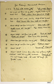
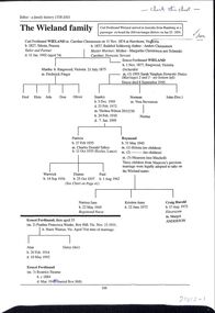
Work on paper, Wieland Family History - various trees and certificates incl descendent chart of Carl Ferdinand WIELAND
Collection of pages (originally in a blue plastic binder labelled "Wieland History"). Includes various trees with Car WIELAND at the head, His oath of Memorialist, Oath of Allegiance, Marriage Certificates and a short typed biography of Raymond Stanley WIELAND -
 Women's Art Register
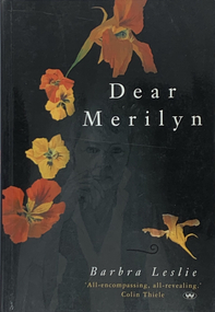
Book, Wakefield Press, Dear Marilyn, 2003
An illustrated autobiography of South Australian artist Barbara Leslie born 1940. Painter and illustrator Leslie charts her life through three sections. Book 1: letters to her best friend Marilyn; Book 2: written to her inner child; Book 3: a diary format after Merilyn's death.non-fictionAn illustrated autobiography of South Australian artist Barbara Leslie born 1940. Painter and illustrator Leslie charts her life through three sections. Book 1: letters to her best friend Marilyn; Book 2: written to her inner child; Book 3: a diary format after Merilyn's death.south australian bushfires, art school, drawing, family