Showing 883 items matching "corner shops"
-
 Brighton Historical Society
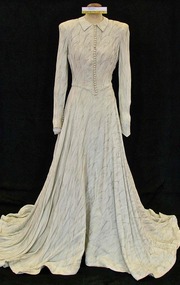
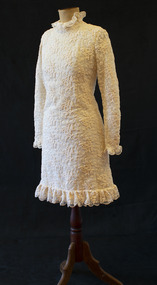
Dress, Wedding dress, 1948
Louris Holly Larsen-Disney married Percy James White at Melbourne Grammar Chapel on 17 June 1948. In later years the dress was given to an opportunity shop and purchased by Mrs Landells of the Brighton Historical Society. Louris subsequently visited the Society and recognised her dress, and was able to provide BHS with information on it. Also in the Society's collection is a 1950s pink strapless silk chiffon dress worn by Louris, and a wedding photo of Louris taken at her mother and stepfather's home at 53 South Road, Brighton. The couple moved into a house just a few doors down, at 49 South Road.Wedding dress made from silver metallic thread crepe. Fastens down front with small self-covered buttons and loops. Long fitted sleeves fastened with 10 covered buttons and loops. Full bias cut skirt with train.wedding dress, 1940s fashion, louris holly white, percy james white, brighton -
 Brighton Historical Society
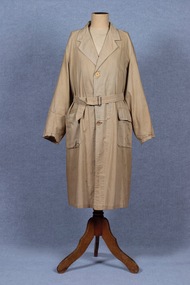
Coat, Dustcoat, c.1948
... and was one of a group of shops near the corner of Centre Road... the corner of Centre Road. In 1944-45 the group of shops included ...Dust coat worn by Mr Frederick Alister Jennings when he managed a family grocery store circa 1948 at 510 Point Nepean Road, East Brighton. Frederick was born at Nagambie, Victoria in 1909 and died in Brighton in 1979. He was the son of Hugh Edwin Jennings and Alice Constance Warren. He married Margaret Jean Hughes in 1934 and served in the Second World War. He lived at 1 Valda Grove Brighton. Frederick was a commercial traveller as well as his time spent managing the store in Point Nepean Road. It is believed this coat dates from his time at the store c1948 - 1955. The store was owned for many years by his father-in-law W. G. Hughes and was one of a group of shops near the corner of Centre Road. In 1944-45 the group of shops included Fletcher’s fuel merchants, a haberdasher, butcher, fruiterer, grocer, Brighton East post office, a ladies’ hairdresser and Hughes’ grocer. In 1950 Hughes’ grocery store was between a service station and the Commercial Bank on what had been renamed Nepean Highway. The business was sold to G. S. Maynard, grocer, sometime before 1960.Unlined dustcoat of beige cotton. Fastens centre front with three brown plastic buttons. Two large patch pockets. Separate cloth belt with metal buckle. Signs of wear and mending. .1 - coat .2 -beltGarment label reads: APEX (RLG.) Dust Coat DEPT. MYER STORE for MEN. MELBOURNE & ADELAIDEdustcoat, occupational dress, grocer, hughes grocery store, brighton, frederick alister jennings -
 Brighton Historical Society
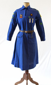
Uniform, Girl Guide uniform, circa 1952-1953
This uniform was worn by Sandra "Sally" Allmand circa 1953-57 as a member of the 3rd St Andrews Girl Guides company in Brighton. Sally Allmand went on to serve on the Brighton Council from 1977 to 1983 and was mayor in 1981.1950s Girl Guides uniform consisting of a dress, belt and beret. Blue cotton dress with long sleeves and high collared neck. Various patches sewn onto sleeves and front breast. Three front pockets fastening with black plastic buttons featuring Girl Guides trefoil logo. Breast pocket has two vertical white stripes. Brown leather belt with silver metal buckle with embossed Girl Guides logo and the text "Girl Guides Association / Be Prepared". Navy blue felt beret with two sewn-on patches. Included with the dress are a Girl Guides 'test card' dated 1953 and a rectangular De Reszke cigarette tin containing a collection of Girl Guide ribbons, patches and buttons. .1 - Dress .2 - Belt .3 - Beret .4 - Test card .5 - Box of patches and ribbonsDress label: "The Guide Shop / STATE HEADQUARTERS / RUN BY GUIDES / FOR GUIDES".girl guides, sally allmand, 1950s -
 Brighton Historical Society
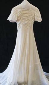
Dress, Wedding dress, 1941
This is the wedding dress of Ella Janetzki, nee Sutcliffe, who married Eric Janetzki in Adelaide on 25 January 1941. The dress was made to measure in a shop in Rundle Street, Adelaide, and cost four guineas. Eric had enlisted in the army in 1940 and was called to duty in 1941, which determined the date of the wedding - though Eric very nearly didn't make it! He caught the train from his home town of Nhill, Victoria on the eve of the wedding only to be held up by flooding on the tracks, ultimately arriving three hours late amid much fuss. Ella later said that there were so many setbacks it was amazing they married at all. They remained together for 58 years until Eric's death in 1999. The dress was also worn by Ella's sister Eileen in October 1943 when she married Jack Edwards at the Church of Christ, LaTrobe Terrace, Geelong. As this was during the war, the sisters did not have enough clothing coupons to purchase another dress. BHS also holds Ella's daughter Rayleen Haig's wedding dress (T0131).Cream lace wedding dress with high square collar, short puffed sleeves and long train.wedding dress, wartime bride, 1940s, ella sutcliffe, ella janetzki, eric janetzki, eileen sutcliffe, jack edwards -
 Brighton Historical Society
Dress, Stage costume, circa 1950s-70s
Purchased from an opportunity shop, this dress is a stage costume bearing the label of Bonn & Mackenzie, a prominent UK costume designer from the 1950s to the 1970s. The dress appears to have been worn by June Bronhill (1929-2005), a prominent Australian opera singer and actress, whose name is handwritten on the label. Born June Mary Gough, she began using the stage name of Bronhill in 1952 in honour of her NSW home town of Broken Hill as a form of thanks to the local community who had helped raise money to send her overseas for professional training as a singer. Bronhill trained in London and gained early exposure with the English National Opera. She went on to star in many theatrical productions in Australia and the UK. She moved back to Australia permanently in 1976, and in 1980 was cast in her first television role as Mrs Crawford in the Australian version of 'Are You Being Served?'.Full-length short-sleeved dress of white cotton, lace and nylon, featuring elaborately ruffled sleeves and vertical stripes of lace on the skirt and bodice. The dress is open at the back, fastening with hooks and cotton ties to facilitate quick costume changes.Label, white cotton with red text: "BONN & MACKENZIE LTD. / TEMPLE BAR 1393". Handwritten underneath in black pen: "JUNE BRONHILL".june bronhill, bonn & mackenzie, theatre costume -
 Brighton Historical Society
Dress, Wedding dress, 1968
This wedding dress belonged to Barbara Stewart, nee Bellamy, who married Alexander Stewart at St Andrews Church in Brighton on 15 June 1968. The dress was made by 'Madam', a dress shop in Church Street. At the time of donation, Barbara had been a Brighton resident for 80 years.Cream mini-dress of net and wool lace with textured floral pattern. High round neck and long sleeves, with small frill at collar, cuffs and hem. Satin lined, with a zip at the back.barbara bellamy, barbara stewart, alexander stewart, st andrew's church brighton, 1960s, wedding dress -
 Brighton Historical Society
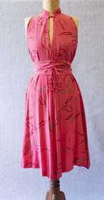
Dress, circa 1980
This dress belonged to Bayside woman Wendy Young, who bought it around 1980 from Melbourne designer Prue Acton's Toorak shop for about $300. She recalled, "It was one of her off the peg creations, but I never saw it on anyone else... she made limited runs, especially as this is hand painted silk." The belt has been signed by Acton.Sleeveless bias-cut dress of watermelon pink silk featuring red and gold hand-painted abstract designs. The dress features a Mandarin collar with a button fastening at the throat. A matching silk belt with tapered ties wraps around the waist.The belt features two signatures in gold paint: "Prue" and "P Acton"prue acton, 1980s, melbourne designers, wendy young -
 National Wool Museum
Photograph - Product Photograph, Semi-Continental Card Set
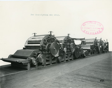
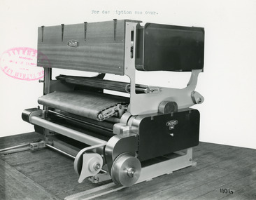
These are sales photographs for William Tatham Ltd. of Rochdale. These photographs are taken in the fitting shop at William Tatham Ltd. where final assembly would have taken place. A carding machine disentangles and cleans wool fibres and then aligns the individual fibres so that they are parallel with each other.The photographed machine was made by William Tatham Ltd, a textile engineering company based in Rochdale, UK. Established in 1866 Tatham developed innovative textile machinery and send their products to Australia and other countries around the world.Two black and white photos of an Semi-Continental Card Set in a landscape format. The first photo is of the whole machine, the second is a close up of the mid section of the machine.8038.1 - Front - top margin: For description see over. Front mid right edge - Wm. TATHAM Ltd. ROCHDALE. Machine Maker Front bottom right corner - 1131 Rear - Semi-Continental Card Set arranged to receive latest pattern Automatic Feed fitted with Peralta, improved type Parallel Fiber Feed permitting of passageway between Scribbler and Carder. Four-tier Continuous Tape Condenser. 8038.2 - Front - top margin: For description see over. Front mid right edge - Wm. TATHAM Ltd. ROCHDALE. Machine Maker Front bottom right corner - 1132 Rear - Showing Peralta with hydraulic pressure to rollers and working with improved pattern Parallel Fibre Feed arranged with passage between the two main sections.textile machinery, tatham, carding machine, wool manufacture -
 National Wool Museum
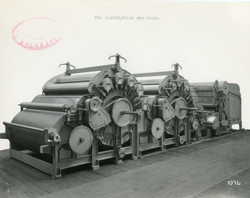
Photograph - Product Photograph, Two-Part Scribbler
These are sales photographs for William Tatham Ltd. of Rochdale. These photographs are taken in the fitting shop at William Tatham Ltd. where final assembly would have taken place. The scribbler was the first part of a group of machines known collectively as the carding engine. The photographed machine was made by William Tatham Ltd, a textile engineering company based in Rochdale, UK. Established in 1866 Tatham developed innovative textile machinery and send their products to Australia and other countries around the world.A black and white photo of a Two-Part Scribbler in a landscape format.Front - top margin: For description see over. Front bottom right corner - 1076 Rear - Two-Part Scribbler, Semi-Continental Type with Patent Automatic Feed having Extended Hopper. Cylinders in this case are 50” diam. Doffers 36” diam. Drive to strippers and other parts by ‘V’ Belts. Note improved guarding to Fancy Chain Drives, also feeder gearing.textile machinery, tatham, wool manufacture, scribbler, carding -
 National Wool Museum
Photograph - Product Photograph, Patent Parallel Fibre Feed
These are sales photographs for William Tatham Ltd. of Rochdale. These photographs are taken in the fitting shop at William Tatham Ltd. where final assembly would have taken place. The Patent Parallel Fibre Feed machine is used for connecting Breaker and Finisher Card Sections. The photographed machine was made by William Tatham Ltd, a textile engineering company based in Rochdale, UK. Established in 1866 Tatham developed innovative textile machinery and send their products to Australia and other countries around the world.A black and white photo of a Patent Parallel Fibre Feed in a landscape format. Black wiritng on the rear, typed with a typewriter. Front - top margin: For description see over. Front mid left edge - Wm. TATHAM Ltd. ROCHDALE. Machine Maker Front bottom right corner - 1106 On machine bottom right quadrant - TATHAMS Rear - New Patent Parallel Fibre Feed for connecting Breaker and Finisher Card Sections. This Machine incorporates a completely new type Plaiter Motion, the operation of which is quite unique.textile machinery, tatham, wool manufacture, carding, patent parallel fibre feed machine -
 National Wool Museum
Photograph - Product Photograph, Patent Automatic Feed Machine
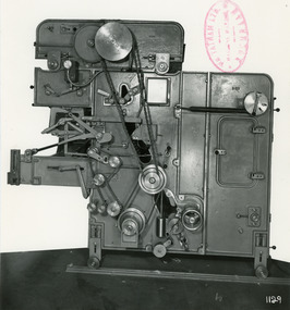
These are sales photographs for William Tatham Ltd. of Rochdale. These photographs are taken in the fitting shop at William Tatham Ltd. where final assembly would have taken place. An Automatic Feeding Machine automatically and sequentially supplies uncarded wool to carding machines, The photographed machine was made by William Tatham Ltd, a textile engineering company based in Rochdale, UK. Established in 1866 Tatham developed innovative textile machinery and send their products to Australia and other countries around the world.A black and white photo of a Patent Automatic Feed Machine in a portrait format. Black wiritng on the rear, typed with a typewriter.Front - mid left corner - Wm. TATHAM Ltd. ROCHDALE. Machine Maker Front bottom right corner - 1129 Rear - Patent Automatic Feed with Extended Hopper fitted with balanced pressure plate which operates through Variable Speed Device to regulate speed of spiked lattice in accordance with material in Hopper. Electro-Magnetic Clutch Drive to spiked lattice controlled by Mercery Switch on scale arm. Diagonal Scale Pan with improved knife edge suspension. Dual Trap Doors over Pan actuated by Solenoid. Automatic device to slow spiked lattice just prior to weigh being obtained. Ball or roller bearings to main shaft, combs and other parts. Self-aligning bearing to timing shaft etc.textile machinery, tatham, wool manufacture, carding, automatic feeding machine, wool -
 Port Fairy Historical Society Museum and Archives
Photograph, c.1886
... This shop stood at the corner of Bank and Church Streets... Street Port Fairy great-ocean-road This shop stood at the corner ...This shop stood at the corner of Bank and Church Streets and was pulled down to make way for another service station. When the service station closed in the 1990's it was used as a storage unit for a Port Fairy builder. It in turn has been pulled down and replaced with 2 shops, a bank and two units above.Black & white photographshop, commercial, warehouse, bank street, church street -
 Port Fairy Historical Society Museum and Archives
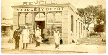
Photograph, c.1886
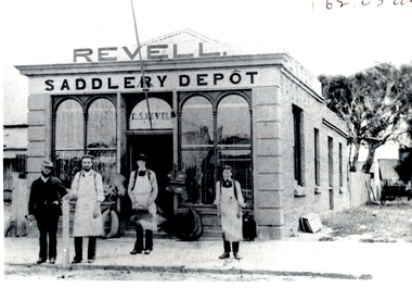
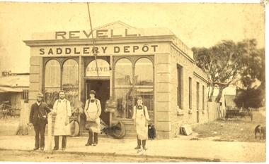
Revell's Saddlery Depot on the corner of Bank and Church streetsBlack & white photographshop, commercial, warehouse, revell, saddler, depot -
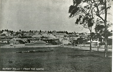 Surrey Hills Historical Society Collection
Photograph, Surrey Hills from north of Montrose Street 1907-1911
In the foreground is Dr Blakie's first surgery, later the Police Station, then a Service station. Behind and to the left are the two railway station buildings. On the horizon and in front of the pine trees is 'Montalto', home of the Hansen family, later Dr Box (demolished). Two storey terrace of shops in front of this is Hansen's Terrace. In centre, note smoke from steam train. On corner of Guildford Rd is a Gas Lamp. The first trees have been planted in Union Road and are protected with stout wood surround.Black and white photograph of a view of Surrey Hills. Written on the bottom left hand side "SURREY HILLS - FROM THE NORTH". In the foreground are two trees on the right hand side before a view leading up the hill. dr blakie, police station, hansen terrace, dr box, montalto, guildford rd, gas lamp, union road -
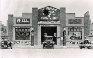 Surrey Hills Historical Society Collection
The Principal Garage at 260 Canterbury Road, Surrey Hills, After 1927
David Staig Jnr established this business in 1927 on the corner of Canterbury Road and Revers Street. He lived at 355 Canterbury Road, one of a series of shops (with living accommodation) owned and built in c1885 by Thomas C Hyde. G Staig (farmer) was the first in the family to occupy this, followed by James Staig (carpenter), then David Staig Snr (blacksmith) and David Staig Jnr. Bill Steiner was the chief mechanic at The Principal Garage; his apprentice Frank Senior eventually bought the business from David Staig and it became Senior's Garage. In 2020 there is a Shell service station and a Coles Express on the site. The Staig family were long-time residents of the area and this photo documents part of their business history. Dave Staig, who established this business, was an early aviator who designed and built his own plane.Black and white photo of a classic 1920's era garage build in brick and render and with 2 petrol bowsers on the curbside, either side of the central garage entrance. Advertising on the facade indicates Shell and Plume motor oils. There are 3 cars positioned in such a way that suggests this may have been a publicity photo. Advertising on the facade indicates that cars could be garaged at the facility and that the proprietor was D. Staig. It also indicates that the business was an agent for The Whippet car, the Willys-Knight car and the Overland car.principal garage, senior's garage, senior's motors pty ltd, garages, redvers street, canterbury road, david staig jnr, bill steiner, frank senior -
 Port Fairy Historical Society Museum and Archives
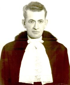
Photograph - Portrait photograph, Hill, Alexander George Mayor of Borough of Port Fairy 1944 1945 1962 1970
Alexander George Hill Mayor 1944 1945 1962 1970 His home and boot shop was in Sackville Street - first shop from the old Post office corner. Alex was very involved in the Port Fairy Football Club.Black & white portrait of Alexander Hill wearing mayoral robes and jabotmayor, government, shire, council, municipal, portrait, local government, football club -
 Port Fairy Historical Society Museum and Archives
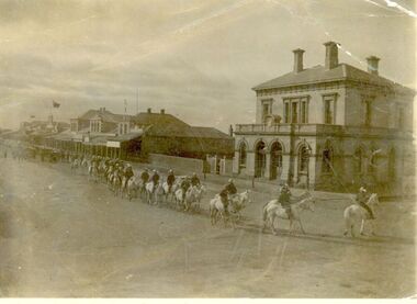
Photograph, Light Horse- Procession
Light Horse Procession. Corner of Cox and Sackville, you can see old Post Office and Eastside of Sackville Street shops.Black and white Photographdefence, light horse, procession, sackville street -
 Port Fairy Historical Society Museum and Archives
Photograph, c.1886
... This shop stood at the corner of Bank and Church Streets... Street Port Fairy great-ocean-road This shop stood at the corner ...This shop stood at the corner of Bank and Church Streets and was pulled down to make way for another service station. When the service station closed in the 1990's it was used as a storage unit for a Port Fairy builder. It in turn has been pulled down and replaced with 2 shops, a bank and two units above.Black & white photographMrs C.W. Freckleton Toolong.- my father's saddlery business-shop now owned by Mr Richter taken in 1880shop, commercial, warehouse, bank street, church street -
 Canterbury History Group
Photograph - Geo. Carnell, upholsterer, c1938
... Geo. Carnell and Sons original shop on the corner of Balwyn... Road Upholsterers Geo. Carnell and Sons original shop ...Geo. Carnell and Sons original shop on the corner of Balwyn and Canterbury Roads with dwelling abovecanterbury, geo. carnell and sons, balwyn road, canterbury road, upholsterers -
Canterbury History Group
Photograph - Youngs Milk Bar and Dairy, Susan Barnett, 1996
Black and white photograph of Youngs Milk Bar corner of Highfield Road and Leeds Street Canterburycanterbury, highfield road, leeds street, milk bars, shops, dairies, dairy farmers milk, herald sun, barnett> susan -
Canterbury History Group
Photograph - Young's Milk Bar and Dairy, Susan Barnett, 1/06/2012 12:00:00 AM
Black and white photograph of Young's Milk Bar and Dairy corner of Highfield Road and Leeds Street, Canterburycanterbury, highfield road, leeds street, milk bars, shops, dairies, advertising signs, barnett> susan -
Canterbury History Group
Photograph - Young's Milk Bar and Dairy, Susan Barnett, 1/06/2012 12:00:00 AM
Black and white photograph of Young's Milk Bar and Dairy, corner of Highfield Road and Leeds Street Canterburycanterbury, highfield road, leeds street, milk bars, shops, dairies, advertising signs, barnett> susan -
Canterbury History Group
Photograph - Street view of the Canterbury Post Office, Stuart Warmington, 1995
Coloured photograph of street view of the Canterbury Post Office on the corner of maling and Canterbury Roads at 206 Canterbury Roadcanterbury, maling road, shops, edwardian architectural design -
Canterbury History Group
Photograph - Street view of the new shop on the corner of maling Road and Scott Street, Stuart Warmington, 1995
... Street view of the new shop on the corner of maling Road...Coloured photograph of street view of the new shop... view of the new shop on the corner of maling Road and Scott ...Coloured photograph of street view of the new shop on the corner of maling Road and Scott Streetcanterbury, maling road, shops -
 Melton City Libraries
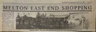
Newspaper, Melton East end shopping, 1992
TOM COLLINS–from the reel to reel tape recording at Melton 1969 In the years between 1890 and to about 1913 Melton was a quiet little hamlet alongside the Toolern Creek, once called the Pennyroyal Creek, 24 miles from Melbourne on the Ballarat Road. There was a fair amount of woodland left around it, mostly grey and yellow box with sheoak, and golden wattle, which in spring time made a rather attractive setting. Most of the premises were in the main or High Street, with its line of elm and pepper trees on each side. Unitt, McKenzie and Henry streets each contained only a few dwellings. Hotels were four in number, Minns’s, Mrs Hay licencee, now Mac’s, Golden Fleece – Sheblers. The Royal or Ryan’s as it was then called, later Graham had the licence, and the Raglan - Kilpatricks had the licence and afterwards Tom Manning. This was situated about where Mr K. Young had his residence. There was a store attached to the hotel until about 1900. Both the Royal and the Raglan were delicensed, later on the Royal being converted to a green grocery and a boarding house, the Raglan was demolished. The Royal green grocery and boarding house was kept by E Carew and after he retired, E Radford. The Post and Telegraph Office was on the opposite side of the street to the Raglan Hotel about two doors west of the Shire Hall and was kept by Mrs Ferris and Lady Farmer until her retirement, when it was carried on by Miss Lottie Ross. A store was attached to the Post Office and was sometimes used as a store and at one time housed the National Bank. There were two full time banks at Melton, the other being the Commercial which built premises about 1904 and on the corner of High and Smith Streets, which it still occupies. Mr G Egan was the manager of the Commercial and Mr Stradling and later Mr Lee of the National. However as business was not thought good enough they reverted to a part time branch operated from Bacchus Marsh. Grocer shops were Chalmers, with a news agency and drapery now Arnolds, Jongebloeds had the bakery. Mr Fox also a produce merchant, was where Melton Real Estate is now, it was later occupied by Buchanans, Atleys, and Mrs Ross. Not long after the War Mrs Ross built the Post Office, since demolished where Miss Lottie Ross was the Post Mistress and later built the store which she conducted. It was later turned into a factory and in now the barbers shop. McNichols was just west of the Minns Hotel. He travelled as far a Ballan weekly, buying calves and dairy produce for sale in Melbourne. Afterwards he sold the business and bought Minns Hotel and changing the name to Macs. Blacksmiths were three in number. Blackwoods – later James Byrnes next door to Jongebloeds. Alex Cameron who learnt his trade with Blackwoods had his shop about the rear of where Ken Youngs Garage is now he later moved to the north west corner of High and Alexander Street. He was also the Registrar of Birth and Deaths and Electoral Registrar. After his retirement he was weighbridge keeper at Melton South. Two of his sons were engaged in the carpentry trade, but both died at an early age. Whittingtons shop was a few doors east of the Mechanics Hall and it was later occupied by Gordon Macdonald who did business there until about eight years ago. The butchers of the period were George Graham, that is where Mandy Lees hairdressing establishment is now. Euan MacDonald had premises later occupied by Whittingtons blacksmith shop. Later shifting next door. He left here about 1901, he slaughtererd animals at a slaughter house right where Chas Jones now resides, it had previously been a slaughter house and butcher shop of that site. George Spring also operated as a butcher for two or three years about the 1900 or so. Ted Simpsons shop was where John Kontek now has his Estate Agency, he used it as an branch shop from Bacchus Marsh bringing meat from there by a two horse lorry. Jimmy Butler the manager was well known and loved, his son was later a steeplechase jockey. The Court House and Police Station would be built sometime before 1900. The Constables at the time were McGuire, later Wade, Riely and McKenzie after that Robert Wilson and Seinfort were here, they were a bit later on. The Mechanics Hall was first opened by Ryan of the Royal Hotel who sold it to the Hall Committee. It was on Unitt Street and it was moved by McLellans the house shifters from Unitt Street to its present site. Bluestone premises formerly occupied by the bootmaker Carew, were later demolished and replaced by the brick frontage to the Hall. Keith Orensini [?] the local bricklayer built brick portion to the Hall. In the cottage adjoining the Hall a Frenchman named Baudin, had a boot repairing business.This cottage was the later residence of J Hill, a local carpenter and builder from whom I learnt my trade. Granny Watts was the well known local nurse and operated the Mid-Wifery Hospital in Yuille Street on the Sherwin Street corner. Mrs Nissen was on the opposite side of Yuille Street a short distance nearer the township. She conducted the laundry. Carew had a greengrocers shop next door to the Post Office in the High Street for some time before transferring to the Royal Hotel site. He also bought [?] calves for killing. W Cecil was a tank maker and also had a produce round, he lived on Pyke and Sherwin Street. Later Gus Shebler, builder and carpenter engaged in tank making being well known for good workmanship. Shebler was very energetic in forming the Gun Club which met for a good number of years where the golf course now has its headquarters. Of the four churches only three are in use, Christ Church, Scots and St Dominics. The Methodist closed down but later transferred to Melton South. Monthly stock sales were held at the yards in Unitt Street at Minns Hotel by McPhail Auctioneers, later held by McCarthur and McLeod. After the Council built the pound and sale yards they transferred sales to these premises, but lack of patronage caused them to be abandoned. A familiar sight in the district was blind Bob Nixon, who lived in a tumbled down cottage in Centenary Road near W Coburns, being led by his dog down the road to Melton, that is Palmerston street, to the Post Office, butcher and baker for his supplies and then back home. He was able to do his own cooking and other chores. Sundays he would come down Raleighs Road to the back of the church and tie his dog to a tree. Someone, mostly one of the boys would guide him into the church and out again after the service, when the dog would lead him home again. State School 430, a two roomed bluestone building it was the only school in the district, none at Melton South. The nearest would be Rockbank and Toolern Vale. Scholars had a fair distance to walk in most cases. The teachers were Mr T Lang Headmaster. I put a query here, Miss Winters, I’m not certain of the name, Mrs Skinner and Miss Silke as Assistant Teachers. Miss Augusta Cecil and Miss Maud Lang were Junior teachers. One boy who attended the school about the turn of the century was Hector Fraser who resided with his parents in Keilor Road, where Jim Gillespie now lives. He was an excellent gun shot and at the age of about 17 years his father took him to France or Monaco where he won the Gran Prix for pigeon shooting and became the champion boy shot of the world. However he died there from pneumonia. He shot under the name of “Parvo”. The Melbourne Hunt Club used to meet in Keilor Road north side just east of the Toolern Creek on what was originally Pykes Run. This was also the place where the races were held and the Sports Meetings. Dave Murphy, employed at Clarke’s Rockbank Station usually provided the fox which he liberated for the Club. Greyhound coursing was usually held on Moylans property Mt Kororoit, or Mt Misery as it was known then. Later it was held at Melton Park, Mr Matt Carberry was the judge and Percy Cook the slipper. Early in the 1900’s the Recreation Park was created and the Caledonian and the ANA sports meetings were held there, they were annual events. L Paterson from Melton South was a successful competitor in all the cycling events as a young man. He later in life became the Deputy Chief Officer of the Metropolitan Fire Brigade. The present Chief Officer of the Fire Brigade is John Paterson, nephew of his, and spent his early life in Exford where his father was manager of the Exford Estate. Notes Tom Collins was born c 1895. He lived on the south side of the Ballarat Road near the intersection of Keilor Road.Historical image of Palmerston Street in Meltonlocal architecture, landscapes of significance -
 Kilmore Historical Society
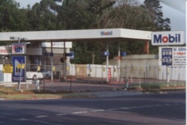
Photograph, Mobil Garage, c2001
Mobil Garage was owned by Danny and Pat D'Elia, they left the premises in 2001.15cm x 10cm colour image of the abandoned Mobil Garage on the corner of Lancefield Road and Sydney Street. Original photograph on standard glossy photograph paper, AGFA brand. Two photographs with slightly differing viewsautomobil repair shops, garages (auto repair), service stations -
 Kilmore Historical Society
Photograph, 11 and 13 Sydney Street
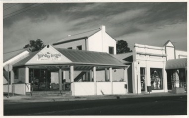
13 Sydney street was the site of J. Quinn bakery and the site of Breakells Bakery.20.5cm x 13cm black and white photograph of the Hey Dey Arcade which the main awning/gazebo of the complex is on the corner at 11 Sydney Street. Also to the right of the awning is the building which was Breakells Bakery. The shop at that premises in the photo is J.R. Menswear.Written on the back: 12/13 KOSR-245 560 63%bakers, bakery, bakers and bakeries -
 Kilmore Historical Society
Photograph, 13 Sydney Street, 1980's?
Was the site of J. Quinn Bakery and Breakells Bakery.20.5cm x 13cm black and white photograph of the Hey Dey Arcade and a view of the shops at 13 Sydney Street. The two shops that can been seen is J.R. Menswear and Country Corner (Clothing store). Pictured is the restoration of the older building at 13 Sydney Street and they new builds surrounding the older shopfront.Written on the back: 1026bakery, bakers and bakeries, baker -
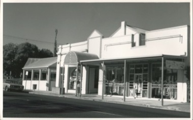
 The Beechworth Burke Museum Research Collection
Card (Series) - Index Card, George Tibbits, Corner of Ford and Church Streets, Beechworth, 1976
George Tibbits, University of Melbourne. Faculty of Architecture, Building and Town & Regional PlanningIndex system that support the research for Beechworth : historical reconstruction / [by] George Tibbits ... [et al]Arranged by street names of BeechworthEach index card includes: street name and number of property, image of property, allotment and section number, property owners and dates of ownership, description of the property according to rate records, property floor plan with dimensions.beechworth, george tibbitsbeechworth, george tibbits -
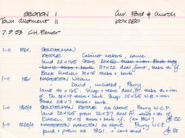
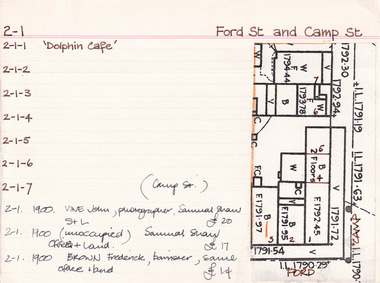 The Beechworth Burke Museum Research Collection
Card (Series) - Index Card, George Tibbits, Cnr Ford and Camp Streets, Beechworth, 1976
George Tibbits, University of Melbourne. Faculty of Architecture, Building and Town & Regional PlanningIndex system that support the research for Beechworth : historical reconstruction / [by] George Tibbits ... [et al]Arranged by street names of BeechworthEach index card includes: street name and number of property, image of property, allotment and section number, property owners and dates of ownership, description of the property according to rate records, property floor plan with dimensions.beechworth, george tibbitsbeechworth, george tibbits