Showing 56198 items
matching crossing-the-line
-
 Ringwood and District Historical Society
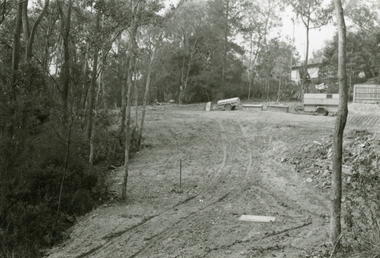
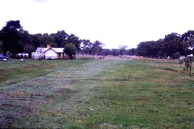
Photographs, 1979-80 MMBW pipe line project at Hubbard Reserve, North Ringwood � Viewing east from Debbie Place
Part of a 43-photo record of the MMBW�s engineering feat in drilling a 12 inch pipe line up to 40 feet deep through rock hardened by volcanic action associated with geological fault that occurs along the line. The work took place from October 1979 to May 1980 on the southern boundary of Hubbard Reserve, North Ringwood. The collection was presented to the Ringwood Historical Research Group by J Clarke on 9th June 1980.E568 N18 13 May 1980 A43 Viewing east from ridge above Debbie Place -
 Ringwood and District Historical Society
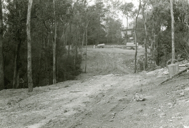
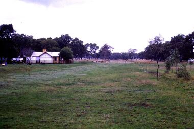
Photographs, 1979-80 MMBW pipe line project at Hubbard Reserve, North Ringwood � Looking east near Debbie Place
Part of a 43-photo record of the MMBW�s engineering feat in drilling a 12 inch pipe line up to 40 feet deep through rock hardened by volcanic action associated with geological fault that occurs along the line. The work took place from October 1979 to May 1980 on the southern boundary of Hubbard Reserve, North Ringwood. The collection was presented to the Ringwood Historical Research Group by J Clarke on 9th June 1980.E567 N16 13 May 1980 A43 Looking east from the ridge above Debbie Place. The finished manhole is in the gully. -
 Ringwood and District Historical Society
Photographs, 1979-80 MMBW pipe line project at Hubbard Reserve, North Ringwood � View east from Debbie Place
Part of a 43-photo record of the MMBW�s engineering feat in drilling a 12 inch pipe line up to 40 feet deep through rock hardened by volcanic action associated with geological fault that occurs along the line. The work took place from October 1979 to May 1980 on the southern boundary of Hubbard Reserve, North Ringwood. The collection was presented to the Ringwood Historical Research Group by J Clarke on 9th June 1980.E558 N29 13 May 1980 A43 View east from Debbie Place -
 Ringwood and District Historical Society
Photographs, 1979-80 MMBW pipe line project at Hubbard Reserve, North Ringwood � Manhole behind 29 Burlock Avenue
Part of a 43-photo record of the MMBW�s engineering feat in drilling a 12 inch pipe line up to 40 feet deep through rock hardened by volcanic action associated with geological fault that occurs along the line. The work took place from October 1979 to May 1980 on the southern boundary of Hubbard Reserve, North Ringwood. The collection was presented to the Ringwood Historical Research Group by J Clarke on 9th June 1980.E566 N5 13 May 1980 A43 Manhole behind 29 Burlock Avenue, 38 feet deep. Debbie place is on the far right. -
 Ringwood and District Historical Society
Photographs, 1979-80 MMBW pipe line project at Hubbard Reserve, North Ringwood � Air track drill rig
Part of a 43-photo record of the MMBW�s engineering feat in drilling a 12 inch pipe line up to 40 feet deep through rock hardened by volcanic action associated with geological fault that occurs along the line. The work took place from October 1979 to May 1980 on the southern boundary of Hubbard Reserve, North Ringwood. The collection was presented to the Ringwood Historical Research Group by J Clarke on 9th June 1980.E561 N19 3 March 1980 A43 Air track drill rig in position as in N18 -
 Ringwood and District Historical Society
Photographs, 1979-80 MMBW pipe line project at Hubbard Reserve, North Ringwood � Drill rig
Part of a 43-photo record of the MMBW�s engineering feat in drilling a 12 inch pipe line up to 40 feet deep through rock hardened by volcanic action associated with geological fault that occurs along the line. The work took place from October 1979 to May 1980 on the southern boundary of Hubbard Reserve, North Ringwood. The collection was presented to the Ringwood Historical Research Group by J Clarke on 9th June 1980.E561 N17 3 March 1980 A43 Powder-monkey marks out the spots for holes -
 Ringwood and District Historical Society
Photographs, 1979-80 MMBW pipe line project at Hubbard Reserve, North Ringwood � View towards Debbie Place
Part of a 43-photo record of the MMBW�s engineering feat in drilling a 12 inch pipe line up to 40 feet deep through rock hardened by volcanic action associated with geological fault that occurs along the line. The work took place from October 1979 to May 1980 on the southern boundary of Hubbard Reserve, North Ringwood. The collection was presented to the Ringwood Historical Research Group by J Clarke on 9th June 1980.E561 N15 3 March 1980 A43 View towards Debbie Place, showing 2 swivel cranes at shafts, timber of manhole in creek, the tracked drill rig and its compressor caravan. -
 Ringwood and District Historical Society
Photographs, 1979-80 MMBW pipe line project at Hubbard Reserve, North Ringwood � Boring mole pit
Part of a 43-photo record of the MMBW�s engineering feat in drilling a 12 inch pipe line up to 40 feet deep through rock hardened by volcanic action associated with geological fault that occurs along the line. The work took place from October 1979 to May 1980 on the southern boundary of Hubbard Reserve, North Ringwood. The collection was presented to the Ringwood Historical Research Group by J Clarke on 9th June 1980.E561 N14 3 March 1980 A43 View west behind No. 29 Burlock Avenue, showing gantry over manhole 38 feet deep. -
 Ringwood and District Historical Society
Photographs, 1979-80 MMBW pipe line project at Hubbard Reserve, North Ringwood � View from Debbie Place, preliminary sewer work
Part of a 43-photo record of the MMBW�s engineering feat in drilling a 12 inch pipe line up to 40 feet deep through rock hardened by volcanic action associated with geological fault that occurs along the line. The work took place from October 1979 to May 1980 on the southern boundary of Hubbard Reserve, North Ringwood. The collection was presented to the Ringwood Historical Research Group by J Clarke on 9th June 1980.E561 N13 28 Feb 1980 A43 View from Debbie Place, preliminary sewer work -
 Ringwood and District Historical Society
Photographs, 1979-80 MMBW pipe line project at Hubbard Reserve, North Ringwood � First hole west of bore hole at 39 Burlock Avenue
Part of a 43-photo record of the MMBW�s engineering feat in drilling a 12 inch pipe line up to 40 feet deep through rock hardened by volcanic action associated with geological fault that occurs along the line. The work took place from October 1979 to May 1980 on the southern boundary of Hubbard Reserve, North Ringwood. The collection was presented to the Ringwood Historical Research Group by J Clarke on 9th June 1980.E561 N9 Feb 1980 A43 First hole west of bore hole at 39 Burlock Avenue -
 Southern Sherbrooke Historical Society Inc.
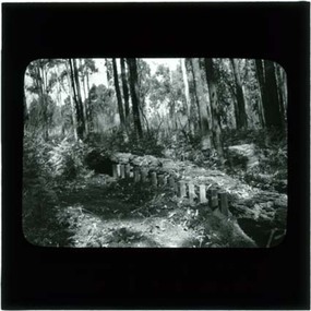
Photograph, Termite fence line test, Belgrave
Black and white photo, c.1923-32, taken from a lantern slide, showing a termite fence line test along a termite-infested log. Log is surrounded by open forest. -
 Flagstaff Hill Maritime Museum and Village
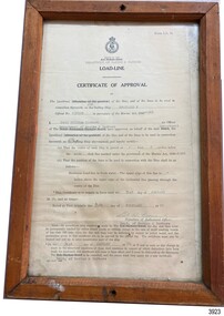
Document - Certificate of Approval, Load Line, 25-02-1970
This Certificate, Load-Line, gave approval for the vessel Reginald M to load cargo up to a certain line, marked by a disc attached to the ship and inspected by the South Australian Harbors Board. The vessel had a long and varied life of service. This Certificate relates to early 1970, before the ship was sold to the Lyall Mining and Rail Company. The Load Line on the Reginald M was carved on the ship, inside the hull and not removeable. The REGINALD M - The vessel “Reginald M” was a two-masted coastal ketch, owned and built by Mr. Jack (John) Murch of Birkenhead, Port of Adelaide, South Australia. Its construction took approximately 6 months and it was launched at Largs Bay in 1922. The Reginald M’s purpose was to serve the coastal trade of South Australia, to carry cargo cheaply and efficiently. It is believed that the keel was in fact hewn from two telegraph poles! Its builder frequented all the salvage yards for materials and fittings. Reginald M had a very shallow draft and a flat bottom that enabled it to come close to shore and to sit high and dry at low tide or to be beached on sand. The flat bottom was also to make the ship able to skim over reefs. Wagons could load and unload direct from her side. Her cargo included Guano, Barley, Wool, Horses, Cattle, Timber, Explosives, Potatoes, Shell Grit and Gypsum. After a variety of services, in late 1970 Reginald M was sold to the Mt. Lyell Mining and Railway Company and was used by them as a barge to carry explosives. In 1972 the Navy League of Strahan, Tasmania, purchased her for use by the Strahan Sea Cadet Unit to use at Macquarie Harbour and renamed her T.S. Macquarie. However this plan for use of Reginald M did not come to pass. In 1974 Mr. Andrew Rennie, of East Brighton, Melbourne, bought her for a similar purpose. , paying $5,000 and donating a ‘Cadet of the Year” trophy to the Sea Cadets. He sailed her from Strahan to Melbourne, planning to use her for pleasure sailing. Also in 1975 Reginald M was sold to Melbourne Ferry Company at auction. Later in 1975 the Reginald M was bought by Flagstaff Maritime Museum for $20,000 . She has been restored and is now one of the exhibits in the Village lagoon or lake. It was restored in 2006 using funds from a $4,000 government grant.This Certificate is significant because of its association with the last working days of REGINALD M. REGNIALD M was a coastal trading ketch from South Australia built in 1922. It was one of very few sailing coastal trading vessels still existing until 2016, and its flat bottom, single chine shape illustrated a very simple but robust method of construction, compared to other round bilged examples of trading vessels. The vessel is listed on the Australian Register of Historic Vessels (ARHV Number: HV000562.)Certificate, rectangular, behind glass in wooden frame. Certificate is an official printed form, some information is over-typed, other information is hand written and signed. Frame has a central hole in top and bottom. The Certificate relates to Load Level of the vessel Reginald M and refers to the exact placement of a disc within the vessel that indicates the maximum load in fresh water. . Issued to the vessel 'Reginald M', Official Number 137228. . Issued by the Sough Australian Harbors Board . Valid from 25-02-1970 to 31-01-1974. . Signed by Neil Cormack, 25th February 1970Certificate of Approval - Load Line for sailing vessel Reginald M, Official Number 137228. Logo of the South Australian Harbors Board. Issued by Department of Marine & Harbors, Port Adelaide, 25th February 1970. In force until 31st January 1974. Signed by Neil William Cormack, authorised officer for Department of Marine & Harbors. Typed onto form: "AUX [SAILING SIP]" "REGINALD M" "137228" "1968" " Neil William Cormack" "Department of Marine & Harbors" "1 [foot] 3 [inches below the] main [deck]" "31st JANUARY 74" "25th FEBRUARY 70" Signature: "Neil W Cormack"flagstaff hill, warrnambool, maritime village, maritime museum, flagstaff hill maritime museum & village, shipwreck coast, great ocean road, coastal trader, reginald m, ketch, john murch, ch murch, reg webb, carribie station, mt lyell copper company, melbourne ferry company, certificate of approval, load line, 137228, load line disc, 25-02-1970, neil w cormack, neil william cormack, south australian harbors board, department of marine and harbors, harbours -
 Ballarat Tramway Museum
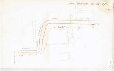
Map, Ken McCarthy, Map of Proposed National Park Line - SPER, mid 1950's
Hand drawn plan on plain foolscap paper of proposed tram line from Loftus to View Point within National Park for South Pacific Electric Railways - with notes, proposed destination roll.trams, tramways, sper, national park line, loftus, destination roll -
 Stawell Historical Society Inc
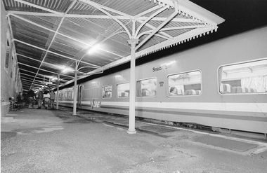
Photograph, Brett Leslie, V/Line train Stawell Railway Station
Two photographs of V/Line train at Stawell Railway Station. Group of Youth are Stawell Jaycee members. July 1989railway, transport -
 Melbourne Tram Museum
Document - Research Notes, H. S. McComb, Lonsdale, Russell St, Lygon St and Elgin and Johnston St to Collingwood line, c1930
Notes 4 pages, pinned together, giving details, opening dates, terminals, depot entries, sheave pits, curves, for the Lonsdale, Russell St, Lygon St and Elgin and Johnston St to Collingwood line. Second set of notes, 3 sheets, for the Madeline St, Swanston St, St Kilda Road and High St St Kida line. Items 2064 to 2075 within box 72.3 in a brown folder marked "MT&O Co." red pencil on the front cover.trams, tramways, mto co, cable trams, drawings, reports, surveys, lonsdale st, russell st, lygon st, collingwood, johnston st, elgin st, madeline st, swanston st, st kilda rd, high st -
 Federation University Historical Collection
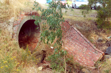
Photograph - Photograph Colour, Clare Gervasoni, Former Ballarat - Buninyong Railway Line Barrel Culvert, 1995, 2005
.1 shows part of a the track still on locationSixteen colour photographs of a brick culvert built as part of the Ballarat - Buninyong Railway Line taken in 1995. The culvert is in disrepair and is located at Mt Helen. The culvert has bricks throughout it and creates a circular tunnel.railway, brick, train, culvert, barrel culvert -
 Port Melbourne Historical & Preservation Society
Document - Ticket, Spirit of Tasmania, TT Line Company Ltd, 8 Dec 2008
Used by Pat GraingerTicket for Spirit of Tasmania cabin number 8221, female share berth C. White ticket with red & blue logo . Reverse side has passenger information.piers and wharves - station pier, transport - shipping, spirit of tasmania, t tline, pat grainger -
 Sandhurst Diocese Historical Commission
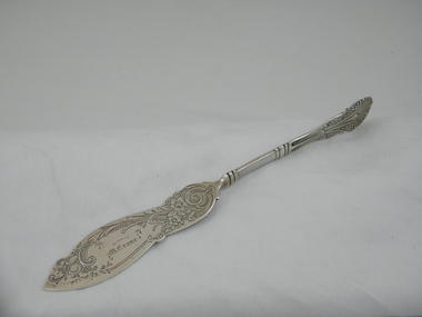
Knife, Circa 1870 - 1900
Martin Crane was the first Bishop of Sandhurst. 1874 - 1901. The knife was probably a gift and is engraved on the front with his name. Martin Crane was a progressive leader in Sandhurst and built many new schools and churches in the Diocese. The knife is significant because it belonged to the first Bishop of Sandhurst, Martin Crane. Irish born Crane was an Augustinian priest before being ordained in 1874. Crane was Bishop of Sandhurst for 27 years. Elaborately engraved sterling silver knife. Floral, leafy design. Probably a cheese or butter knife. The handle sits 90 degrees to the knife blade. This a part of a cutlery set. Bishop. M. Crane. Engraved on the front of knife. Silversmith's name/symbol engraved on the back of knife blade. Sterling. P??? engraved on the back of knife blade. knife, silverplate, cutlery, catholic clergy -
Moorabbin Air Museum
Book - Broad scope review of the current RAAF training, lifestyles, professions etc, ROYAL AUSTRALIAN AIR FORCE 2001, Fine Line Publishing Pty Ltd, ROYAL AUSTRALIAN AIR FORCE 2001, 2001
Broad scope review of the current RAAF training, lifestyles, professions etc, ROYAL AUSTRALIAN AIR FORCE 2001Jacket cover showing colour photo of RAAF Airwomen with sword and jet belownon-fictionBroad scope review of the current RAAF training, lifestyles, professions etc, ROYAL AUSTRALIAN AIR FORCE 2001 -
 Bendigo Military Museum
Uniform - WORKWEAR, ARMY, ADI, 1991 & 1992
1. Hat - Camouflaged bush hat. Standard army bush hat, 6 cm brim. it has an ad hoc nylon string to hold it on head. It also has a large torn hole in it. 2. Jumper - Khaki, it has camouflaged shoulder pads. It is long sleeved, it has a draw cord for the neck. It has camouflaged pads on the elbows. 3. Shirt - T-shirt, camouflaged, short sleeved. Khaki trims on neck and arms, Size L. 4. Shirt - T-shirt, camouflaged, short sleeved. Khaki trims on neck and arms, Size M.2. Written on label is name "Vaughan".uniforms, aust. army, passchendaele barracks trust -
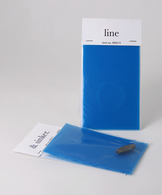 Federation University Historical Collection
Article - Invitation packages, Hook, line and sinker, 2005
The small packs, laser printed black on white paper, were wrapped and stapled to a cellophane bag and blue polycarbonate. The first pack (not in collection) contained a fishing hook. The second contains a small quantity of fishing line, the third houses a sinker. LINE: "we are dropping you a line." Recipients were asked to save the date, Tuesday 29 November, 2005, for the Graphic Design / Multimedia graduate show. Barcode on reverse. SINKER: "it's all about depth" Recipients invited to the University of Ballarat, Graphic Design / Multimedia "End of Year Event" at the Melbourne Aquarium on Tuesday 29 November at 7.00pm, and asked to bring the three pieces of tackle they had received. Barcode on reverse.Two of three teaser packs created as Save the Date by University of Ballarat, Bachelor of Visual Arts (Graphic Design / Multimedia) third year, graduating students, 2005.university of ballarat, federation university, graphic design, multimedia, camp street campus, new north, arts academy -
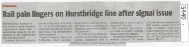 Greensborough Historical Society
Newspaper Clipping, Diamond Valley Leader, Rail pain lingers on Hurstbridge line after signal issue, 02/05/2018
Frustrated commuters face another week boarding replacement buses after a last-minute delay to the re-opening of the Hurstbridge line was announced.News article 1 page, black text.level crossing removal project, rosanna station, hurstbridge rail line -
 Greensborough Historical Society
Map, Greensborough Map with Rail Line Plan, 1970s
Central Greensborough area, including railway line and some landowners. Basic map made c. 1902; annotations dated to circa 1970sTwo copies of planParish of Keelbundora, County of Bourke. Central Greensborough areagreensborough, greensborough railway station -
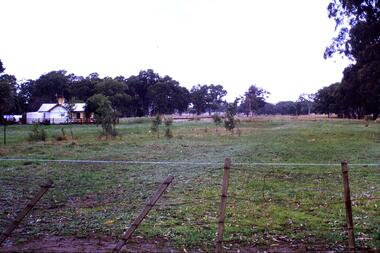 Greensborough Historical Society
Slide - Photograph, John Ramsdale, Rail line near Whittlesea: Slide 120, 1990s
Photograph shows what appears to be a rural farmhouse and paddock, this is part of the site of the old railway line to Whittlesea. In centre of photo is the old station platform.Part of the John Ramsdale collection of slides and audio visual material.Colour photograph scanned from slide.No maker's marks. No caption on slide.whittlesea, whittlesea rail line -
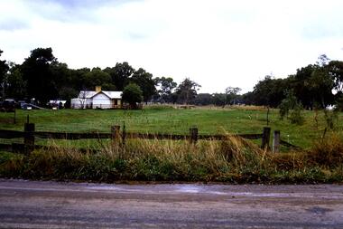 Greensborough Historical Society
Slide - Photograph, John Ramsdale, Rail line near Whittlesea: Slide 94, 1990s
Photograph shows what appears to be a rural farmhouse and paddock, this is part of the site of the old railway line to Whittlesea. In centre of photo is the old station platform.Part of the John Ramsdale collection of slides and audio visual material.Colour photograph scanned from slide.No maker's marks. No caption on slide.whittlesea, whittlesea rail line -
 Greensborough Historical Society
Slide - Photograph, John Ramsdale, Old Whittlesea rail line: Slide 107, 1990s
Photograph shows what appears to be a rural farmhouse and paddock, this is part of the site of the old railway line to Whittlesea. In centre of photo is the old station platform.Part of the John Ramsdale collection of slides and audio visual material.Colour photograph scanned from slide.No maker's marks. No caption on slide.whittlesea, whittlesea rail line -
 Greensborough Historical Society
Slide - Photograph, John Ramsdale, Old railway line Whittlesea: Slide 47, 1990s
Photograph shows what appears to be a rural farmhouse and paddock, this is part of the site of the old railway line to Whittlesea. In centre of photo is the old station platform.Part of the John Ramsdale collection of slides and audio visual material.Colour photograph scanned from slide.No maker's marks. No caption on slide.whittlesea, whittlesea rail line -
 Dutch Australian Heritage Centre Victoria
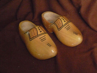
Footwear - Clogs, Company with markings V Z, where the V is located above the Z
... Company with markings V Z, where the V is located above the...The Netherlands ...Wooden shoes are / have been widely used in North-Western Europe (Scandinavia, parts of Germany, UK, The Netherlands, Belgium and Northern France). The models vary from a wooden sole and toe covering (Scandinavia, UK, Northern France) to a complete cover of the whole foot (The Netherlands and parts of Belgium). They are mostly made from poplar wood, but occasionally also from other softwoods like willow. The clogs' finish varies from plain wood or carved wood to varnished or painted versions, often with decorations. Nowadays special models are made for tourists with pictures of Dutch landscapes, tulips or windmills.Although wooden shoes are also used in other countries, the full foot covering model has become one of the symbols of the Netherlands, like the tulips and the old style houses in towns like Amsterdam.Pair of male size wooden clogs - completely covering feet, finished with clear varnish and shoe lace like decorations.Brand indication V Z clog and size 43/44 = 28 1/2cm - Shoe laces like decorations.wooden shoes holland dutch traditional clothing -
 Melbourne Tram Museum
Album - Photo Album, Keith Stodden, construction of Bundoora line and then its operation, Early 1980's
Set of two "Quick as a Flash" photo album comprising 24 pages with clear plastic sheets on either side of a white plastic containing photographs of the construction of Bundoora line and then its operation. Photos may be by Keith Stodden.trams, tramways, photo album, bundoora, construction, new tramway, plenty road -
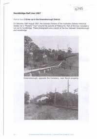 Greensborough Historical Society
Article and Photograph, Hurstbridge Rail Line 1967, 2016_
Information and photos about the Hurstbridge Rail Line in 1967. Photographs courtesy Paul de Sauty, include those taken on the journey from Greensborough to Hurstbridge.This photograph and text was copied from a Facebook site. Members are people who lived in the Greensborough area and share their reminiscences of the area with others. The site is administered by a GHS member but is not officially affiliated with the Society. Any information is the opinion of the contributor. Article and photograph sourced from social media.hurstbridge rail line, greensborough station