Showing 3566 items matching "environments"
-
 Eltham District Historical Society Inc
Photograph, Former Eltham Police Residence, 728 Main Road, Eltham, c.1985, 1985c
This photo is believed to have been taken circa 1985 when the Shire of Eltham Parks and Environment occupied the site. This photo was originally mounted on 3mm MDF fibre board with notes and stickers applied as part of a display on the former Police Residence and now present day Local History Centre, home to Eltham District Historical Society; possibly put together by Harry Gilham during his time as president of the society. Eltham Police Station and Residence: A brief history 1860 Eltham Courthouse built in Main Road, together with an adjoining police residence, office, lock–up and stables. 1959 Police Department purchases a house in Pryor Street to be refurbished as Eltham Police Station 1961 Police in Eltham move into Pryor Street refurbished buildings and office. c.1961-1981 Occupied by Vermin and Noxious Weeds Destruction Section of the Department of Crown Lands and Survey. Former Police Station dragged around to rear of Police Residence (prior to August 1967) to make way for the construction of a driveway and access from Main Road. The building was placed on the site of a former Scullery and modified for Lands Department use. 1981 Shire of Eltham take over management of old Police Residence in Eltham. It remains unoccupied for a period of time whilst its future is discussed in Council. 1981-1985 Used for community job creation scheme 1985 Shire of Eltham Parks and Environment occupy the residence. Council improve the driveway but later add a second rear access from Brougham Street due to the dangerous nature of the Main Road entrance. Also add a rear toilet facility between the Police Residence and former Police Station, which was doubling up as a lunch room. Council also commence discussions to re-establish a replica Police Station. c.1986 November. Former Police Station demolished; believed to have been suffering termite damage. c.1989 After some years of discussion a replica Police Station is built, based on photographs, to act as a lunch room and meeting room for Parks and Environment staff and volunteers doing community service. 1996 Eltham District Historical Society in discussions with Nillumbik Shire Council commisioners throughout the year regarding a home for the Society. A proposal put forward by the Society in October to occupy the former Police Residence. 1997 March. Eltham District Historical Society gains access to former Police Residence. 1998 July 12th. Eltham District Historical Society Inc moves into its Local History Centre, 728 Main Road Eltham (the former Police Residnce built in 1860). 2018 July. Eltham District Historical Society gains access to the replica Police Station for use as part of regular heritage tours for schools and community based groups.Colour printHandwritten in faded blue felt pen ink "Roof of room 5 (weatherboard office) and W.C. See No. 2 for another view"728 main road, eltham, local history centre, parks and environment, police residence, police station, shire of eltham -
 Eltham District Historical Society Inc
Photograph, Former Eltham Police Residence, 728 Main Road, Eltham, c.1985, 1985c
This photo is believed to have been taken circa 1985 when the Shire of Eltham Parks and Environment occupied the site. This photo was originally mounted on 3mm MDF fibre board with notes and stickers applied as part of a display on the former Police Residence and now present day Local History Centre, home to Eltham District Historical Society; possibly put together by Harry Gilham during his time as president of the society. Eltham Police Station and Residence: A brief history 1860 Eltham Courthouse built in Main Road, together with an adjoining police residence, office, lock–up and stables. 1959 Police Department purchases a house in Pryor Street to be refurbished as Eltham Police Station 1961 Police in Eltham move into Pryor Street refurbished buildings and office. c.1961-1981 Occupied by Vermin and Noxious Weeds Destruction Section of the Department of Crown Lands and Survey. Former Police Station dragged around to rear of Police Residence (prior to August 1967) to make way for the construction of a driveway and access from Main Road. The building was placed on the site of a former Scullery and modified for Lands Department use. 1981 Shire of Eltham take over management of old Police Residence in Eltham. It remains unoccupied for a period of time whilst its future is discussed in Council. 1981-1985 Used for community job creation scheme 1985 Shire of Eltham Parks and Environment occupy the residence. Council improve the driveway but later add a second rear access from Brougham Street due to the dangerous nature of the Main Road entrance. Also add a rear toilet facility between the Police Residence and former Police Station, which was doubling up as a lunch room. Council also commence discussions to re-establish a replica Police Station. c.1986 November. Former Police Station demolished; believed to have been suffering termite damage. c.1989 After some years of discussion a replica Police Station is built, based on photographs, to act as a lunch room and meeting room for Parks and Environment staff and volunteers doing community service. 1996 Eltham District Historical Society in discussions with Nillumbik Shire Council commisioners throughout the year regarding a home for the Society. A proposal put forward by the Society in October to occupy the former Police Residence. 1997 March. Eltham District Historical Society gains access to former Police Residence. 1998 July 12th. Eltham District Historical Society Inc moves into its Local History Centre, 728 Main Road Eltham (the former Police Residnce built in 1860). 2018 July. Eltham District Historical Society gains access to the replica Police Station for use as part of regular heritage tours for schools and community based groups.Colour printHandwritten in faded blue felt pen ink "Another view of north wall 728 No. 4. Taken from west end towards back yard"728 main road, eltham, local history centre, parks and environment, police residence, police station, shire of eltham -
 Eltham District Historical Society Inc
Photograph, Former Eltham Police Residence, 728 Main Road, Eltham, c.1985, 1985c
This photo is believed to have been taken circa 1985 when the Shire of Eltham Parks and Environment occupied the site. This photo was originally mounted on 3mm MDF fibre board with notes and stickers applied as part of a display on the former Police Residence and now present day Local History Centre, home to Eltham District Historical Society; possibly put together by Harry Gilham during his time as president of the society. Eltham Police Station and Residence: A brief history 1860 Eltham Courthouse built in Main Road, together with an adjoining police residence, office, lock–up and stables. 1959 Police Department purchases a house in Pryor Street to be refurbished as Eltham Police Station 1961 Police in Eltham move into Pryor Street refurbished buildings and office. c.1961-1981 Occupied by Vermin and Noxious Weeds Destruction Section of the Department of Crown Lands and Survey. Former Police Station dragged around to rear of Police Residence (prior to August 1967) to make way for the construction of a driveway and access from Main Road. The building was placed on the site of a former Scullery and modified for Lands Department use. 1981 Shire of Eltham take over management of old Police Residence in Eltham. It remains unoccupied for a period of time whilst its future is discussed in Council. 1981-1985 Used for community job creation scheme 1985 Shire of Eltham Parks and Environment occupy the residence. Council improve the driveway but later add a second rear access from Brougham Street due to the dangerous nature of the Main Road entrance. Also add a rear toilet facility between the Police Residence and former Police Station, which was doubling up as a lunch room. Council also commence discussions to re-establish a replica Police Station. c.1986 November. Former Police Station demolished; believed to have been suffering termite damage. c.1989 After some years of discussion a replica Police Station is built, based on photographs, to act as a lunch room and meeting room for Parks and Environment staff and volunteers doing community service. 1996 Eltham District Historical Society in discussions with Nillumbik Shire Council commisioners throughout the year regarding a home for the Society. A proposal put forward by the Society in October to occupy the former Police Residence. 1997 March. Eltham District Historical Society gains access to former Police Residence. 1998 July 12th. Eltham District Historical Society Inc moves into its Local History Centre, 728 Main Road Eltham (the former Police Residnce built in 1860). 2018 July. Eltham District Historical Society gains access to the replica Police Station for use as part of regular heritage tours for schools and community based groups.Colour printHandwritten in faded blue felt pen ink "Repeat view of No. 4 from external corner of weatherboard extn. Room 5"728 main road, eltham, local history centre, parks and environment, police residence, police station, shire of eltham -
 Eltham District Historical Society Inc
Photograph, Former Eltham Police Residence, 728 Main Road, Eltham, c.1985, 1985c
This photo is believed to have been taken circa 1985 when the Shire of Eltham Parks and Environment occupied the site. This photo was originally mounted on 3mm MDF fibre board with notes and stickers applied as part of a display on the former Police Residence and now present day Local History Centre, home to Eltham District Historical Society; possibly put together by Harry Gilham during his time as president of the society. Eltham Police Station and Residence: A brief history 1860 Eltham Courthouse built in Main Road, together with an adjoining police residence, office, lock–up and stables. 1959 Police Department purchases a house in Pryor Street to be refurbished as Eltham Police Station 1961 Police in Eltham move into Pryor Street refurbished buildings and office. c.1961-1981 Occupied by Vermin and Noxious Weeds Destruction Section of the Department of Crown Lands and Survey. Former Police Station dragged around to rear of Police Residence (prior to August 1967) to make way for the construction of a driveway and access from Main Road. The building was placed on the site of a former Scullery and modified for Lands Department use. 1981 Shire of Eltham take over management of old Police Residence in Eltham. It remains unoccupied for a period of time whilst its future is discussed in Council. 1981-1985 Used for community job creation scheme 1985 Shire of Eltham Parks and Environment occupy the residence. Council improve the driveway but later add a second rear access from Brougham Street due to the dangerous nature of the Main Road entrance. Also add a rear toilet facility between the Police Residence and former Police Station, which was doubling up as a lunch room. Council also commence discussions to re-establish a replica Police Station. c.1986 November. Former Police Station demolished; believed to have been suffering termite damage. c.1989 After some years of discussion a replica Police Station is built, based on photographs, to act as a lunch room and meeting room for Parks and Environment staff and volunteers doing community service. 1996 Eltham District Historical Society in discussions with Nillumbik Shire Council commisioners throughout the year regarding a home for the Society. A proposal put forward by the Society in October to occupy the former Police Residence. 1997 March. Eltham District Historical Society gains access to former Police Residence. 1998 July 12th. Eltham District Historical Society Inc moves into its Local History Centre, 728 Main Road Eltham (the former Police Residnce built in 1860). 2018 July. Eltham District Historical Society gains access to the replica Police Station for use as part of regular heritage tours for schools and community based groups.Colour printHandwritten in faded blue felt pen ink "Backdoor to residence. White paint still visible 2010 on brickwork"728 main road, eltham, local history centre, parks and environment, police residence, police station, shire of eltham -
 Eltham District Historical Society Inc
Photograph, Former Eltham Police Residence, 728 Main Road, Eltham, c.1985, 1985c
This photo is believed to have been taken circa 1985 when the Shire of Eltham Parks and Environment occupied the site. This photo was originally mounted on 3mm MDF fibre board with notes and stickers applied as part of a display on the former Police Residence and now present day Local History Centre, home to Eltham District Historical Society; possibly put together by Harry Gilham during his time as president of the society. Eltham Police Station and Residence: A brief history 1860 Eltham Courthouse built in Main Road, together with an adjoining police residence, office, lock–up and stables. 1959 Police Department purchases a house in Pryor Street to be refurbished as Eltham Police Station 1961 Police in Eltham move into Pryor Street refurbished buildings and office. c.1961-1981 Occupied by Vermin and Noxious Weeds Destruction Section of the Department of Crown Lands and Survey. Former Police Station dragged around to rear of Police Residence (prior to August 1967) to make way for the construction of a driveway and access from Main Road. The building was placed on the site of a former Scullery and modified for Lands Department use. 1981 Shire of Eltham take over management of old Police Residence in Eltham. It remains unoccupied for a period of time whilst its future is discussed in Council. 1981-1985 Used for community job creation scheme 1985 Shire of Eltham Parks and Environment occupy the residence. Council improve the driveway but later add a second rear access from Brougham Street due to the dangerous nature of the Main Road entrance. Also add a rear toilet facility between the Police Residence and former Police Station, which was doubling up as a lunch room. Council also commence discussions to re-establish a replica Police Station. c.1986 November. Former Police Station demolished; believed to have been suffering termite damage. c.1989 After some years of discussion a replica Police Station is built, based on photographs, to act as a lunch room and meeting room for Parks and Environment staff and volunteers doing community service. 1996 Eltham District Historical Society in discussions with Nillumbik Shire Council commisioners throughout the year regarding a home for the Society. A proposal put forward by the Society in October to occupy the former Police Residence. 1997 March. Eltham District Historical Society gains access to former Police Residence. 1998 July 12th. Eltham District Historical Society Inc moves into its Local History Centre, 728 Main Road Eltham (the former Police Residnce built in 1860). 2018 July. Eltham District Historical Society gains access to the replica Police Station for use as part of regular heritage tours for schools and community based groups.Colour printHandwritten in faded blue felt pen ink "No. 1 South wall of 728 & back of house built 1860 [1859]. Demolition of weatherboard extension into yard area"728 main road, eltham, local history centre, parks and environment, police residence, police station, shire of eltham -
 Orbost & District Historical Society
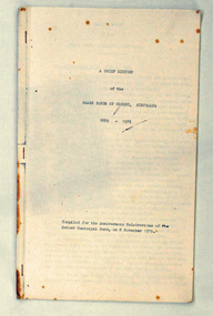
booklet, A Brief History of the Brass Bands of Orbost Australia 1889-1975, 8.11.1975
This booklet was compiled for the anniversary celebrations of the Orbost Municipal Band on November 8, 1975. It was compiled by Peter Fagg who worked as a scientist with the Department of Sustainability and Environment (now DELWP) to study dieback in eucalypts. He specialised in the silviculture of the eucalypt forest types of South-East Australia for most of his 40-year career, which started with the Forests Commission Victoria. He was in Orbost from 1968 - 1973. The first Orbost Brass Band was formed in 1889. Around 1908 the town band split and the Orbost Workers' Band was formed. Eventually the two bands merged in 1913 to reform as the Orbost Municipal Band under conductorship of Charles Spink. The band continued for many years but was later disbanded and again reformed. This was to happen a number of times, the last time being in 1961 and continuing through to the late 1970's. Further info and Ref: In Times Gone By - Deborah HallThe various Orbost bands over the years played a major role in community activities providing entertainment and musical experiences for the many members.A 12 pp stapled booklet compiled for the anniversary celebration of the Orbost Municipal Band. It has been typed in black ink on foolscap sized white paper.orbost-municipal-band music-orbost fagg-peter -
 Orbost & District Historical Society
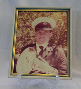
framed coloured photograph, December 1978
Mr E. Knight was the president of the Orbost Municipal Band from 1972 - 1978. The photographer, Peter Fagg, worked as a scientist with the Department of Sustainability and Environment (now DELWP) to study dieback in eucalypts. He specialised in the silviculture of the eucalypt forest types of South-East Australia for most of his 40-year career, which started with the Forests Commission Victoria. He was in Orbost from 1968 - 1973. The first Orbost Brass Band was formed in 1889. Around 1908 the town band split and the Orbost Workers' Band was formed. Eventually the two bands merged in 1913 to reform as the Orbost Municipal Band under conductorship of Charles Spink. The band continued for many years but was later disbanded and again reformed. This was to happen a number of times, the last time being in 1961 and continuing through to the late 1970's. Further info and Ref: In Times Gone By - Deborah Hall The various Orbost bands over the years played a major role in community activities providing entertainment and musical experiences for the many members.A coloured photograph of a man in a band uniform holding a brass instrument ( a french horn?). It is under glass framed in a white and gold wooden frame.on back - ".....E. Knight.......Dec 1978"music recreation orbost-municipal-band knight-g. -
 Eltham District Historical Society Inc
Photograph, Fay Bridge, EDHS Heritage Excursion, Edendale Farm, 5 May 2018
May Excursion – Edendale Environs Edendale Community Environment Farm in Gastons Road, Eltham now operates as Nillumbik Council’s environmental centre. The historic homestead has undergone a significant restoration and there is on-going development of the site consistent with its community education purpose. The house and the gateway sculpture “The Fences Act” are covered by a Heritage Overlay in the Nillumbik Planning Scheme. Our May excursion will comprise a walk through the farm property and will radiate to other nearby places of historic interest. These will include the site of the Eltham North Adventure Playground to discuss its history and destruction by fire (see page 1 article). Also nearby is Colemans Corner where the early road system has undergone some unusual changes. If time permits we may visit some other nearby places of interest. - EDHS Newsletter No. 239 April 2018fay bridge collection, 2018-05-05, edendale community farm, edendale farm, eltham district historical society, heritage excursion, activities -
 Kiewa Valley Historical Society
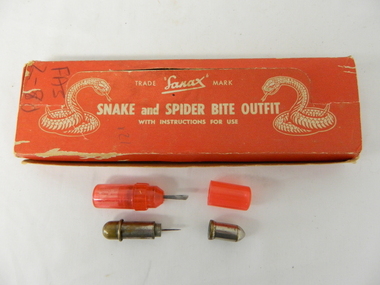
Box First Aid, Snake and Spider Outfit, Circa 1940's
At the time of manufacture, circa 1940's, the first aid treatment for snake bites, was to lance(cut) open the bite, wash it out and apply a ligature or tourniquet between the bite and the heart. This method was abandoned later after scientific evidence suggested that it was better to stop the blood system from carrying the poison to the heart (pressure immobilization). Australian snakes do not have long fangs therefore deep incisions into main arteries is rare. This research took many years to develop therefore the information supplied with the "Sanax" kits of this era is well outdated. Rural areas were more attuned to the possibilities of snake activity on farms, in sheds and in out houses and farm homesteads. This was not the case for mainly city and large townships environments. The mice plagues in wheat areas during the warmer month s has always been a high risk time for encountering snakesThese snake bite kits were issued to workers on the Kiewa Hydro Electricity Scheme. Some of these snake bite kits were kept at doctor's surgeries e.g. Bogong Village, House 13. The kit was carried by bushwalkers, scouts, farmers and high plains cattlemen. This item is of significance because it demonstrates the main dangers faced by all rural industries and towns, especially remote areas, and the portable remedies that where required as a necessity of the Australian bush environment. This item was in use at a time when the air ambulance and rescue facilities were not in existence and remote locations were more isolated and the availability of anti venom was hard to obtain locally.This item is a red coloured cardboard box(250 - 300 g/m) with white writing and containing the following 12 items. 7 clear red coloured capsules, 2 opaque red plastic capsules, 2 wooden capsules and 1 brass screw on capsule. The capsules are divided into two sections (compartments) horizontally. Each compartment has a screw lid. One compartment contains a lancet (for piercing the snake bite) and the other compartment contains the "Condy's" crystals compete with tightly rolled instructions.On top of the pull up lid, and flanked by two coiled snakes (at the strike position) is printed: "Trade Sanax Mark" below this " SNAKE and SPIDER BITE OUTFIT" and below this with instructions for use". Front side: "Sanax snake and spider bite outfit" underneath "Nepean Highway Morabbin" The later printing has been severely scratched but decipherable. The back side of the box has "Note to the retailer" and due to wear no more of the writing can be read. Each side of the box is printed "SANAX" snake, spider, first aid, kiewa hydro scheme, portable medical supplies -
 City of Moorabbin Historical Society (Operating the Box Cottage Museum)
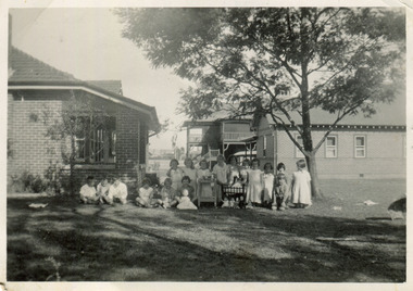
Photograph, Black & White Methethodist Childrens Home Cheltenham , Dolls Tea Party 1935, 1935
A typical leisure activity for children of this era was a doll's tea party. The Methodist Children's Home in Cheltenham was founded c1880 to provide housing for neglected children from the inner city. The Founders aimed to provide regular nourishment, a stable environment and integrate the children into the local community thereby improving their education and lives. However new settlers to Cheltenham area who were seeking a healthier and more respectable lifestyle for their families were not happy to share Church and School with the Home's Children. (see 00561) 1950's saw a new direction for the support of children and families in poor and difficult situations . The new Burwood Homes Facility opened in 1951 and children were transferred from Cheltenham in 1952. The land was sold to the St John of God, Catholic Order in1953 who maintained an orphanage until Myer Pty Ltd bought the site in 1967 and constructed the Southland Shopping Centre c1892-1953 The Methodist Children's Home Cheltenham was founded to provide safe accommodation and education for neglected children from the inner city slums. Black & White photograph of Methodist Children's Home and Cottages combined 'Dolls Tea Party' Cheltenham 1935Back Handwritten informationmethodist childrens home cheltenham 1892-1953, dolls, city of moorabbin, county of bourke, moorabbin roads board, parish of moorabbin, shire of moorabbin, henry dendy's special survey 1841, were j.b.; bent thomas, o'shannassy john, king richard, charman stephen, highett william, ormond francis, maynard dennis, cheltenham state school no.84, methodist chapel cheltenham, methodist school cheltenham, beaumaris west state school, meeres frederick, meeres walter, education, early settlers, -
 Royal Australian and New Zealand College of Obstetricians & Gynaecologists (RANZCOG)
Infant feeding bottle, 'The Ideal Agee', Crown Crystal Glass, c. 1961-63
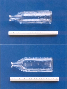
Crown Crystal Glass were an Australian glass manufacturer, who were the Australian vendors for Pyrex from 1926, importing from the UK. In 1961, Crown Crystal Glass began manufacturing their own Pyrex, under the name Agee Pyrex (until 1963), Crown Agee Pyrex (late 1960s), Crown Pyrex (1970s), Crown Ovenware (1970s) and Pyrex Ovenware (late 1970s until early 1980s). Source: That Retro Piece, 'PYREX | Australian', https://thatretropiece.com/collections/pyrex-australian "The use of pyrex bottles became more prevalent in Australia in the second half of the 20th century and baby’s bottles made of pyrex were popular as they were easily sterilised in the home environment." Source: Warrnambool and District Historical Society Inc., 'Bottle, The Perfect Agee Feeding Bottle, Mid 20th century', https://victoriancollections.net.au/items/592fe71ad0cdd520341b3954Octagonal glass bottle tapering to a narrow neck. Calibrations for ounces and mls imprinted on the sides of the bottle. Text inscribed on bottle reads " THE IDEAL AGEE/PYREX/FEEDER"."THE IDEAL AGEE/PYREX/FEEDER"infant feeding, infant care -
 Royal Australian and New Zealand College of Obstetricians & Gynaecologists (RANZCOG)
Infant feeding bottle, 'Agee Pyrex Feeder', Crown Crystal Glass, c. 1961-63
Crown Crystal Glass were an Australian glass manufacturer, who were the Australian vendors for Pyrex from 1926, importing from the UK. In 1961, Crown Crystal Glass began manufacturing their own Pyrex, under the name Agee Pyrex (until 1963), Crown Agee Pyrex (late 1960s), Crown Pyrex (1970s), Crown Ovenware (1970s) and Pyrex Ovenware (late 1970s until early 1980s). Source: That Retro Piece, 'PYREX | Australian', https://thatretropiece.com/collections/pyrex-australian "The use of pyrex bottles became more prevalent in Australia in the second half of the 20th century and baby’s bottles made of pyrex were popular as they were easily sterilised in the home environment." Source: Warrnambool and District Historical Society Inc., 'Bottle, The Perfect Agee Feeding Bottle, Mid 20th century', https://victoriancollections.net.au/items/592fe71ad0cdd520341b3954 Clear glass bottle tapering to a short narrow neck. Calibrations embossed on the glass in ounces (0-8) and mls (0-240). Embossed on the side: "Agee/PYREX/Feeder"."Agee/PYREX/Feeder"infant feeding, infant care -
 Unions Ballarat
Photograph: Norm Borchers and Geoff Howard, November 1997
Photograph: Norm Borchers and Geoff Howard at Waubra. Geoff Howard is the current state member for Buninyong. He has been in parliament since 2009. Howard has also served as a councillor and mayor on Ballarat City Council. Howard has served as Parliamentary Secretary for Natural Resources and the Environment and Parliamentary Secretary for Agriculture. Norm Borchers passed away in 2008. Borchers was a Club President of the Sebastopol Lions Club (1975-76). He worked for the railways as an engineering employee and was long-term trade unionist (Amalgamated Engineering Union and the Australian Railways Union) and ALP member; he lived and worked in the Ballarat area. Norm was active in workplace disputes during the ALP split in 1955. He was a long time supporter of Ballarat Trades Hall. It is assumed that this picture was taken at an ALP barbeque - see pictures 0374 and 0375.Photograph.btlc, ballarat trades hall, ballarat trades and labour council, howard, geoff, politicians, borchers, norm, australian labor party, alp -
 Bayside Gallery - Bayside City Council Art & Heritage Collection
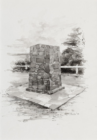
Work on paper - ink and watercolour, Annette Meikle, Moysey Memorial, 1977
In 1977, artist Annette Meikle undertook a commission to illustrate a book recording stories of places and people in the Bayside area. It was published in 1978 as Sandringham Sketchbook, with text by Elizabeth Waters. The sketches were intended to record remaining examples of Bayside’s early architecture and environment, as well as reflect newer architectural changes. Meikle went on to donate 22 of these sketches to Bayside City Council in 2003. Erected in 1964, this stone cairn on Beach Road in Beaumaris marks the site of the wattle and daub cottage of James and Susannah Moysey. James, Susannah and their cousin Nicholas arrived in Victoria in 1844 and leased land on the cliff-top. They built a cottage, cleared the land for sheep and cattle and established vegetable gardens. They later purchased the land and named it Beaumaris Park, derived from the name of the Welsh coastal resort where Edward I built Beau Marais castle.Annette Meikle, Moysey Memorial 1977, ink and watercolour, 35 x 23.5 cm. Bayside City Council Art and Heritage Collection. Donated by the artist, 2003annette meikle, sandringham sketchbook, elizabeth waters, port phillip bay, moysey memorial, coastline, stone cairn, james and susannah moysey, beaumaris -
 Bayside Gallery - Bayside City Council Art & Heritage Collection
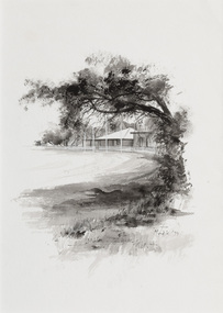
Work on paper - ink and watercolour, Annette Meikle, Donald MacDonald Reserve, 1977
In 1977, artist Annette Meikle undertook a commission to illustrate a book recording stories of places and people in the Bayside area. It was published in 1978 as Sandringham Sketchbook, with text by Elizabeth Waters. The sketches were intended to record remaining examples of Bayside’s early architecture and environment, as well as reflect newer architectural changes. Meikle went on to donate 22 of these sketches to Bayside City Council in 2003. An area of natural bushland on Haydens Road, Beaumaris, was set aside in the early twentieth century as a reserve in memory of journalist and naturalist Donald MacDonald (c. 1859 – 1932). MacDonald was trained as a teacher but became a journalist for The Argus and The Australasian, working as a war correspondent, cricket commentator and nature writer. In 1900 he began the popular Argus column Nature notes and queries. Part of the Donald MacDonald Reserve was later cleared for an oval, a club pavilion and a scouts hall. Annette Meikle, Donald MacDonald Reserve 1977, ink and watercolour, 35.9 x 25.5 cm. Bayside City Council Art and Heritage Collection. Donated by the artist, 2003annette meikle, sandringham sketchbook, elizabeth waters, donald macdonald reserve, donald macdonald, journalist, naturalist, oval, sports pavilion, beaumaris -
 Bayside Gallery - Bayside City Council Art & Heritage Collection
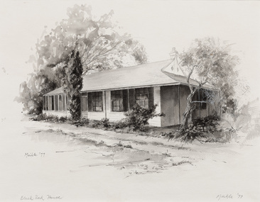
Work on paper - ink and watercolour, Annette Meikle, Black Rock House, 1977
In 1977, artist Annette Meikle undertook a commission to illustrate a book recording stories of places and people in the Bayside area. It was published in 1978 as Sandringham Sketchbook, with text by Elizabeth Waters. The sketches were intended to record remaining examples of Bayside’s early architecture and environment, as well as reflect newer architectural changes. Meikle went on to donate 22 of these sketches to Bayside City Council in 2003. Black Rock House was built in 1858 by wealthy land dealer and politician Charles Hobson Ebden as a holiday home on 112 acres of virgin scrub, taking in the area of present day Balcombe Road, Beach Road and the line of Keating Street. The house included four bedrooms, a cellar, stables and a courtyard enclosed in castle-like sandstone walls. It was named Black Rock House after Black Rock Castle near Dublin, associated with Mrs Ebden’s childhood.Annette Meikle, Black Rock House 1977, ink and watercolour, 33 x 53.5 cm. Bayside City Council Art and Heritage Collection. Donated by the artist, 2003annette meikle, sandringham sketchbook, elizabeth waters, black rock house, black rock, charles hobson ebden, architecture, historic house -
Federation University Art Collection
Oil on canvas, 'Creswick and Camp Hill' by Victor Litherland, 1968 /1984
Victor LITHERLAND (16 April 1897 - 1978_ Born Odessa, Russia (of English parents) Born in Odessa, Russia to British parents, Victor Litherland migrated to Australia in 1926 and moved to Creswick in 1932. Victor Litherland, who initially trained as a carpenter and cabinet maker, not only made most of his furniture and clothes but also his painting equipment. Victor Litherland is self taught himself. In 1943 he used books in the Sydney Public Library to teach himself painting, and produced a number of works of the environment in which he lived. Litherland's work has a disregard for perspective, unmodelled faces and cool fresh colours. He often made an elaborate frame for this work. This item is part of the Federation University Art Collection. The Art Collection features over 1000 works and was listed as a 'Ballarat Treasure' in 2007.art, artwork, victor litherland, naive art, creswick, acrylic on canvas -
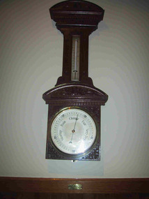 Parks Victoria - Mount Buffalo Chalet
Barometer
"A number of specific items, which have been useful in the day to day operations of the Chalet, remain in the building with each complementing the other to provide context, meaning and character to their setting. Items such as the hall porter bell, the many signs providing information to the guests, the wall clock, barometer and dinner bell point to the Chalet being a well-run social institution with a pleasant environment for rest, recreation and congenial company." (Pg 81 Historica, MBCC) "The barometer mounted on an ornately carved backing was presented by flour miller John Spencer Brunton (1861-1937), son of Thomas Brunton who founded the Brunton & Co. flourmills. John had responsibility for the New South Wales arm of the company and lived in Sydney.' (Pg 82 Historica MBCC) " Fig 80. It was presented by John Spencer Brunton on 9 December 1930."(Pg83, Historica. MBCC) Listed in Draft Inventory of Significant Collection items A.3.. Fixtures and Fittings (Pg 165.Historica, MBCC)Barometer and thermometer with carved decorative leaf pattern wooden surround.On plaque below barometer:"PRESENTED BY / JOHN SPENCER BRUNTON / 9.12.30" (further inscriptions on face) -
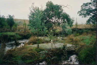 Wooragee Landcare Group
Photograph, 20th June 2004
Photo of streamside planting and rehabilitation at Bev DeJong and Bob Dunnett's place during a paddock demonstration and tree planting field day, called 'Really Successful Tree Planting!' run by Wooragee Landcare on Sunday 20th June 2004. Maintaining and reforesting native trees, shrubs and grasses are really important for a variety of reasons, including creating native habitat and food for birds and other animals, shade, biodiversity, visual appeal, cooling, shade for urban areas, sequestering carbon and conservation among other considerations. The planting must be consistent with the particular needs of the environment, such as trees or shrubs which would naturally occur and are native to the area. Tree planting demonstrations such as this one run by the Landcare Group ensures that the projects are being managed consistently with an overarching commitment to land protection and management and the best methods for best outcomes are employed.This photograph is significant as it provides evidence of a project undertaken by the Wooragee Landcare Group to educate themselves and members of the public on successful techniques needed to plant and maintain trees for replanting in the Wooragee area. The Wooragee Landcare Group has been instrumental in the co-ordination of programs relating to biodiversity protection in the local area, providing great assistance to landholders.Landscape coloured photograph printed on gloss paperReverse: WAN NA 0ANA2N0 AN1 0 1636 / [PRINTED] (No.25) / 938wooragee landcare, wooragee landcare group, beechworth, landcare group, wooragee, tree planting, successful tree planting, demonstration, paddock demonstration, tree planting field day, really successful tree planting, land protection and management, land management, native trees, conservation, streamside, streamside planting -
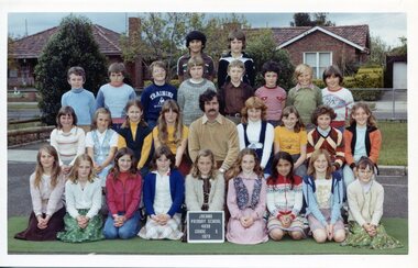 Broadmeadows Historical Society & Museum
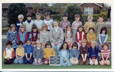
Photograph - Class Photograph, Jacana Primary School: Grade 5, 1979, 1979
This 1979 group photograph of Grade 5 students and their teacher at Jacana Primary School offers a compelling glimpse into the everyday life of a suburban Melbourne school during a time of significant social and urban evolution. Founded in 1959, Jacana Primary was a cornerstone of the local community until its closure in the early 2000s, providing not only education but also a strong sense of identity, belonging, and shared experience. The photograph illustrates the school’s dedication to fostering inclusive and supportive learning environments. It also subtly reflects the increasing cultural diversity of Jacana in the late 20th century, as suburban expansion brought together families from a variety of backgrounds. As part of the school’s visual archive, this image contributes to a broader understanding of how public education helped shape community identity, encouraged social cohesion, and played a formative role in the lives of generations of children and families.This 1979 class photograph of Grade 5 students and their teacher at Jacana Primary School is a historically significant visual record that captures the essence of suburban school life in Melbourne during a period of social and demographic transformation. The image reflects the role of Jacana Primary—established in 1959 and closed in the early 2000s—as a central institution in the community, offering not only education but also a sense of belonging and continuity for local families. The photograph is particularly valuable for its documentation of the cultural diversity emerging in Jacana during the late 20th century, as urban expansion brought together families from varied backgrounds. It illustrates the inclusive and supportive environment fostered by the school, and serves as a testament to the broader role of public education in shaping community identity and promoting social cohesion. As part of Jacana Primary’s visual archive, this image contributes to the collective memory of the school and its impact on generations of students. It holds enduring significance for understanding how schools functioned as social anchors in suburban Melbourne, and how they helped cultivate shared experiences that extended beyond the classroom. Colour Photograph on Matte Paper, with white borderBack: Top Left Corner: (White label): PH-5011/ (Blue Label): PH-5598, Centre (in pencil) J.P.S., Manufacturers Mark; this paper/Manufactured/ by kodakjacana primary school, education, photograph, group photograph, 1979, class photograph, grade 5 -
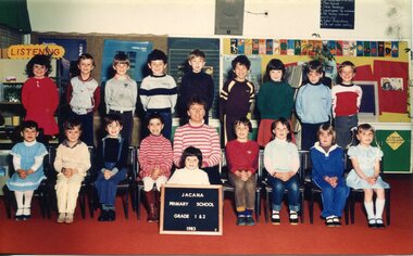 Broadmeadows Historical Society & Museum
Photograph - Class Photograph, Jacana Primary School Grade 1 & 2 1983, 1983
This group photograph, taken in 1983, features Grade 1/2 students and their teacher at Jacana Primary School, offering a snapshot of daily school life during a formative period in the suburb’s history. Jacana Primary was established in 1959 and remained a key educational institution until its closure in the early 2000s. Throughout its operation, the school served as a focal point for the local community, providing not only education but also a space for social connection and shared identity. The image reflects the values that shaped the school’s culture—camaraderie, inclusiveness, and a strong sense of belonging. It also illustrates the broader social environment of Jacana during the late 20th century, a time marked by suburban growth and evolving community dynamics. As part of the school’s visual legacy, the photograph contributes to understanding how educational institutions like Jacana Primary influenced the development of local identity and community cohesion across generations.This 1983 group photograph of Jacana Primary School’s Grade 1/2 students and their teacher offers a compelling glimpse into the everyday life of a school that played a vital role in the Jacana community for over four decades. Established in 1959 and active until the early 2000s, Jacana Primary was more than an educational institution—it was a cornerstone of local identity, nurturing generations through shared experiences, learning, and connection. The image captures not only the individuals present but also reflects the school’s enduring values of inclusivity, friendship, and belonging. As a historical artifact, it provides insight into the social fabric of Jacana during a transformative period and stands as a tribute to the school’s legacy in shaping young lives and fostering community cohesion.Colour Photograph on Satin Finish PaperBack; (Blue Label): PH-5558 (Manufactures Mark): Fujicolor/ Paperjacana primary school, education, photograph, group photograph, grade 1 & 2, 1983 -
 Broadmeadows Historical Society & Museum
Photograph - Class Photograph, Jacana Primary School: Grade 4, 1991, 1991
This 1991 group photograph of Grade 4 students and their teacher at Jacana Primary School offers a valuable window into the everyday experiences of school life in Melbourne’s northern suburbs during the late 20th century. Established in 1959, Jacana Primary served the local community for over four decades before its closure in the early 2000s. More than just a place of learning, the school was a cornerstone of community life—bringing together children, families, and educators in a shared environment of growth and connection. The photograph reflects the school’s emphasis on inclusivity, friendship, and a strong sense of belonging. It also provides insight into the demographic and cultural diversity of Jacana at the time, a period marked by suburban development and shifting social dynamics. As part of the school’s visual archive, this image helps document the role of public education in shaping local identity and fostering intergenerational community ties.This 1991 group photograph of Grade 4 students and their teacher at Jacana Primary School is a culturally and historically significant artifact that reflects the role of public education in shaping community identity in Melbourne’s northern suburbs. Established in 1959, Jacana Primary operated for over four decades, serving as a vital hub for learning, social connection, and community engagement until its closure in the early 2000s. The image captures more than a moment in time—it embodies the school’s enduring values of inclusivity, camaraderie, and belonging. It also offers insight into the demographic and social landscape of Jacana during a period of suburban expansion and cultural change. As part of the school’s visual legacy, this photograph contributes to a deeper understanding of how educational institutions foster intergenerational ties and strengthen the social fabric of their communities.Colour Photograph on Satin Finish PaperBack; See attached for list of Names (White label): PH-5006 (Blue Label): PH-5593jacana primary school, education, photograph, group photograph, kelly kenna, belinda cilia, brigitte paco, lindsay norman, peter massari, kristopher andree-jansz, omar houssein, reece lee, my nguyen, yavuz cavyarli, william warke, darryl king, candice blaney, said el halabi, jade goudge, bridie hogan, belinda hutchinson, tuba sahan, tracey phillips, bradley hooke, janine so, mark bamfield, mr. b. o'dea, sue bourchier, yvonne mcbain -
 Broadmeadows Historical Society & Museum
Photograph - Class Photograph, Jacana Primary School: Grade Prep & 1, 1979, 1979
This 1979 group photograph of Grade Prep and Grade 1 students with their teacher at Jacana Primary School offers a valuable glimpse into the early years of education in Melbourne’s northern suburbs during a time of significant suburban development and cultural change. Established in 1959, Jacana Primary served the local community for over four decades, providing not only academic instruction but also a space for social interaction, inclusion, and community building. The image reflects the school’s commitment to nurturing young learners in a supportive and diverse environment. It also illustrates the demographic shifts occurring in Jacana during the late 20th century, as families from varied backgrounds settled in the area. As part of the school’s visual archive, this photograph contributes to a broader understanding of how public education shaped local identity, fostered community cohesion, and supported the development of children during their formative years.This 1979 group photograph of Grade Prep and Grade 1 students with their teacher at Jacana Primary School is a historically significant artifact that captures the early stages of formal education in Melbourne’s northern suburbs during a time of suburban growth and social transformation. Established in 1959, Jacana Primary served as a vital educational and community institution for over four decades, fostering learning, connection, and a shared sense of identity among local families. The image reflects the school’s foundational values—nurturing, inclusivity, and belonging—through its depiction of young learners at the beginning of their educational journey. It also offers insight into the cultural and demographic diversity of Jacana in the late 20th century, highlighting the role of public schools in supporting social cohesion and community development. As part of Jacana Primary’s visual legacy, this photograph stands as a testament to the enduring impact of early education and the school’s contribution to shaping generations of students and strengthening community bonds.Colour Photograph on Matte Paper, with white borderBack, Top Left Corner: (White label): PH-5008/ (Blue Label): PH-5595, Centre (in pencil) J.P.S., Manufacturers Mark; this paper/Manufactured/ by Kodakjacana primary school, education, photograph, group photograph, 1979, class photograph, grade prep & 1 -
 Broadmeadows Historical Society & Museum
Photograph - Class Photograph, Jacana Primary School: Grade 2, 1979, 1979
This 1979 group photograph of Grade 2 students and their teacher at Jacana Primary School offers a meaningful glimpse into the everyday experiences of primary education in Melbourne’s northern suburbs during a time of suburban expansion and demographic change. Established in 1959, Jacana Primary served the local community for over 40 years, providing not only academic instruction but also a vital space for social connection and community identity. The image reflects the school’s commitment to fostering a nurturing and inclusive environment for young learners in their early years of schooling. It also highlights the cultural diversity and evolving social fabric of Jacana in the late 20th century. As part of the school’s visual archive, this photograph contributes to a broader understanding of how public education supported community cohesion, shaped local identity, and played a formative role in the lives of children and families across generations.This 1979 group photograph of Grade 2 students and their teacher at Jacana Primary School is a historically significant artifact that captures a formative moment in the educational and social life of Melbourne’s northern suburbs. Established in 1959, Jacana Primary operated for over four decades, serving as a key institution in the local community until its closure in the early 2000s. The photograph reflects the school’s enduring commitment to nurturing young learners in an inclusive and supportive environment. It also offers insight into the cultural and demographic landscape of Jacana during a period of suburban growth and transformation. As part of the school’s visual legacy, this image documents the everyday experiences of students and highlights the role of public education in fostering community identity, cohesion, and continuity across generations.Colour Photograph on Matte Paper, with white borderBack, Top Left Corner: (White label): PH-5009/ (Blue Label): PH-5596 Centre (in pencil) J.P.S., Manufacturers Mark; this paper/Manufactured/ by Kodakjacana primary school, education, photograph, group photograph, 1979, class photograph, grade 2 -
 Bendigo Historical Society Inc.
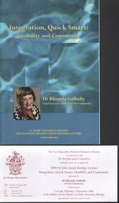
Booklet - Michele Matthews Collection - 2004 Sir John Quick Bendigo Lecture - "Integration, Quick Smart: Disability and Community", 04/02/2025
La Trobe University, Sir John Quick annual lectureMichele Matthews Collection - 2004 Sir John Quick Bendigo Lecture - "Integration, Quick Smart: Disability and Community". presented by Dr Rhonda Galbally at 5:45 PM on Thursday 2 September 2004 in the McKay Lecture Theatre, La Trobe University, Bendigo. Invitation, agenda and lecture notes provided. All our social systems tend to work on the basis of a "medical model" of disablement, where problems are an individual matter based on the consequences of disease or trauma. The "social model", in contrast, sees disablement not as an attribute of the individual but a collection of conditions, many of them created by the social environment. A social justice model provides the opportunity to bring people with disabilities back from the margins and to integrate their needs on an equal footing. Our approach to disablement must be founded on the principles that: * everyone is equal * everyone is entitled to respect and personal autonomy * everyone is entitled to have his or her basic needs met. sir john quick annual lecture, disability, rhonda galbally -
 Ruyton Girls' School
Magazine, Ruyton Reporter, 1999
The Ruyton Reporter (formerly known as Ruyton Reports) captures the essential Ruyton Girls' School experience for the broader school community. It has been produced since 1986.The record has strong historic significance as it pertains to one of the oldest girls' school in Victoria, Australia. Ruyton was founded in 1878 in the Bulleen Road, Kew, home of newly widowed Mrs Charlotte Anderson (now High Street South). Thus, the record can be used as a reference example for research into Victorian school history. It also gives insight into the types of activities and events undertaken at Ruyton Girls' School during the period of its production. The record's significance is further enhanced by its exceptionally well-documented provenance, having remained the property of Ruyton Girls' School since its production.Colour publication printed on paper with staple binding. 16 pages.Front Page: Edited by Deborah Forster / 1 / 9 / theRUYTON / REPORTER / 9 / spring / 9 / The New Learning Communities P2 / "I know I cannot teach / anyone anything. I can only / provide an environment in / which he can learn" / Carl Rogers / INSIDE: / PRINT POST APPROVED / PP 341999 00026 / Ruyton One to One 12 Selbourne Rd / New Board Members Kew VIC 3101 / R / Enchanted Place RECTE ET FIDE LITER Tel: 9819 2422 / ORA / Fax: 9818 4790 / Email: [email protected] Web site: www.ruyton.vic.edu.au /ruyton girls' school, ruyton, school, students, newsletter, ruyton reports, ruyton news, kew, victoria, melbourne, girls school -
Glenelg Shire Council Cultural Collection
Booklet - Program, Portland Upwelling Festival 2010, 2010
Program for the 2010 Upwelling Festival. The Upwelling Festival Portland is a community celebration of the Bonney Upwelling, presented by the Upwelling Festival Incorporated and including a partnership with other community groups. The Upwelling Festival celebrates what is unique about Portland and the community and show cases an important environmental phenomenon – the Bonney Upwelling. The Bonney Upwelling is a unique and epic natural ocean phenomena where the spring winds shift to the south-east driving a change in ocean currents that powers a seven month feeding frenzy of tuna, crayfish, giant crabs, squid, fish, seabirds, seals, krill and blue whales. An incredibly rich ecological food web, the Upwelling is at its greatest off the coast of Portland and is the cornerstone of the lucrative local fishing and tourism industry. The Festival is a free event maintaining the key elements of the Blessing of the Fleet, Street Parade, Festival markets, local entertainment, Marine Environment Talks and community art projects on the site.Upwelling FestivalA4 sheet folded in 4, to make program advertising Upwelling Festival 2010. Glossy white paper, illustrations on front cover in blues, greens. Back cover sponsors logos. Inside pages, Festival explanation and list of events. Two copies.upwelling festival, events, tourism, whales, portland -
 City of Moorabbin Historical Society (Operating the Box Cottage Museum)
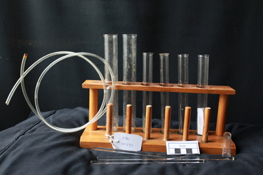
Manufactured GLass, test tubes, mixers, 20thC
A test tube, also known as a culture tube or sample tube, is a common piece of laboratory glassware consisting of a finger-like length of glass or clear plastic tubing, open at the top, usually with a rounded U-shaped bottom. Test tubes are widely used by pharmacists to hold, mix, or heat small quantities of solid or liquid chemicals, especially for qualitative experiments and assays. Their round bottom and straight sides minimize mass loss when pouring, make them easier to clean, and allow convenient monitoring of the contents. The long, narrow neck slows down the spreading of vapours and gases to the environment. Test tubes are usually held in special-purpose racks, Test tubes for physics and chemistry are usually made of glass for better resistance to heat and corrosive chemicals and longer life. Tubes made from expansion-resistant glasses, such as borosilicate glass, can be placed directly over a Bunsen burner flame.8 clear glass test tubes of varied capacity with 3 glass mixers sitting in a wooden stand. A 1 metre length of clear plastic tubing is with this setglass manufacturers, test tubes, culture tubes, sample tubes, borosilicate glass, otto schlott, felton grimwade company, melbourne glass bottle works, laboratory glass, pharmacy, moorabbin, bentleigh, cheltenham, spotswood melbourne -
 Kiewa Valley Historical Society
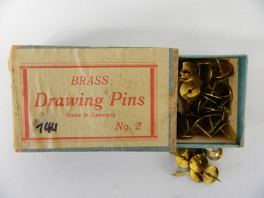
Pin Drawing, Brass tacks, mid to late 1900's
This particular box of brass drawing pins would have been used before the introduction of cheaper polished chrome drawing pins manufactured in Asia. The box construction and label would suggest that supply of this boxes contents could have been in the early 1950's. Drawing pins or push pins were first invented in 1900 by Mr Edwin Moore. The need for a secure fastener to accommodate temporary signs and notes for domestic and commercial environments sprang up from the need to cope with an increasing faster method of presenting information on removable surfaces such as temporary notice boards. In the 1950's and later the increase in the pace of "living" brought about many time saving written communication notices. This temporary method of providing fast temporary notices is being surpassed by the computer age and mobile telephone "applications". The information spectrum of the computer age has made many "hands on" (drawing pin) applications go to the "dodo" level. This box of drawing pins is very significant to the Kiewa Valley and its region because it demonstrates that the pace in rural regions especially those that were once semi remote regions has moved at the same pace as the bigger towns and cities. Differences are still noticeable, such as the requirement of drawing pins for temporary signs and mail box commercially important "sales" notifications. The pressures that produce the "rat" syndrome, that is pressure by increased population levels infringing upon the individual's day-to-day existence is still not present in rural areas such as the Kiewa Valley. Drawing pins are still a requirement for leased accommodation (which are usually short term accommodation) for the personalisation of "home" wall decorations and shopper's "notice and information boards"This small box, similar to a "match box" (thumb activated slide, top open, cardboard container), holds brass drawing pins. These brass pins are also known as brass tacks, thumbtacks or push pins. The top of the brass tack has a "domed head" with the manufacturer's logo stamped on it. The number "2" on the bottom right of the label is the "weight" of the drawing pin. On the front and within a red border and red letters "BRASS" and below this in script form "Drawing Pins" and below this in smaller letters "Made In Germany" Below this and on the bottom left side "100" and also on the bottom but to the right "No. 2"notice and information boards, quick temporary fasteners., pins, tacts, brass tacts, domestic, decorations -
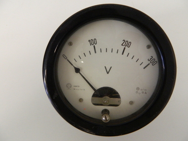 Kiewa Valley Historical Society
Meter Volt, mid to late 1900's
This analog voltmeter is quite a large (industrial type) apparatus which permits the easy monitoring of electrical variations within the large SEC Victoria Hydro Scheme's electrical generators. These generators are powered by the hydro force of "stored" water at a higher altitude. The establishment of both the NSW and Victorian Hydro schemes was achieved from the mid 1900's to the 1960's. At this point in time the need for additional power sources to quench both an industrial and domestic demand for electricity was purely an economic and not and environmental (carbon reduction) factor. This hydro scheme was instigated by "the Government of the day" as a bold move and was the major force of the World War II refugee and "technical" workforce inclusion of skilled and unskilled migration into the Australian environment. Although this mass "invasion" of workers with families was thought of in some circles as intrusive, the expansion of population post war years and its integration into the Australian rural sector, produced the multi- lingual multi-cultural diversity of later years. This voltmeter is very significant to the Kiewa Valley as its use was introduced during the Kiewa Hydro Scheme. Although only a small apparatus it was part of the explosion of human resources into the valley. This influx of population transformed the region from that of a basically quiet rural region to one which evolved into both an industrial and a larger residential community. This evolution in the valley created a change, not only in the "physical" landscape but also the socio-economic expansion which permitted other "tourist" based industries into the valley. This analog volt meter has two metal rods protruding from the "back" of instrument with screw on points for the negative and the positive leads allowing the "current" to flow across the calibrated resistors to indicate on the "face" side the strength of the voltage "power". The "face" of the instrument has a zero point and then five evenly graduated marks from Zero to the "100, 200 and 300" marked points of measures. A large "V" below these pointers indicates that they represent levels of voltage. Three small screws hold the "face" in place. At the back of the meter is an aluminium "clasp" with three protruding screws (positioning fasteners) and a a screw tightening fixture for the correct fastening of the "clasp" into the correction location on the meter "board".Manufacturer's logo "CSG" underneath "ITALIA"kiewa valley tourism, victorian alps, alternate energy supplies, alpine population growth