Showing 858 items
matching kew (vic) - roads
-
 Kew Historical Society Inc
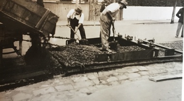
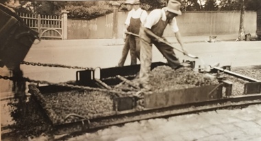
Photograph - Street Works, Studley Park Road, March 1934
... studley park road -- kew (vic.)....) studley park road -- kew (vic.) city of kew -- engineers ...Studley Park Road, like most streets in Kew, was originally a dirt road. Street works during the Great Depression included bituminising major roads in the district. This photograph of Council works originated in the City of Kew Engineers Department as a record of works undertaken. It was given to the collection by a Mrs Fisher in 1998.Well provenanced photograph of Council-funded public works in Kew during the Great Depression. Original sepia monochrome positive of Council workers spreading bitumen in Studley Park Road, Kew.Typed reverse: "B4 / Kew C.C. / Spreading premixed material on Studley Park Road with drag spreader, March 1934"roadworks -- kew (vic.), street works -- kew (vic.), public works kew (vic.), studley park road -- kew (vic.), city of kew -- engineers department, city of kew -- public works -- great depression -- 1930s -
 Kew Historical Society Inc
Photograph - Street Works, Studley Park Road, March 1934
... studley park road -- kew (vic.)... road -- kew (vic.) city of kew -- engineers department city ...Studley Park Road, like most streets in Kew, was originally a dirt road. Street works during the Great Depression included bituminising major roads in the district. This photograph of Council works originated in the City of Kew Engineers Department as a record of works undertaken. It was given to the collection by a Mrs Fisher in 1998.Well provenanced photograph of Council-funded public works in Kew during the Great Depression. Original sepia monochrome positive of Studley Park Road, Kew.Typed reverse: "B4 / Kew C.C. / Studley Park Road after surfacing with one coat of premixed material spread with drag, March 1934"roadworks -- kew (vic.), street works -- kew (vic.), public works kew (vic.), studley park road -- kew (vic.), city of kew -- engineers department, city of kew -- public works -- great depression -- 1930s -
 Kew Historical Society Inc
Photograph - Street Works, Studley Park Road, March 1934
... studley park road -- kew (vic.)....) studley park road -- kew (vic.) city of kew -- engineers ...Studley Park Road, like most streets in Kew, was originally a dirt road. Street works during the Great Depression included bituminising major roads in the district. This photograph of Council works originated in the City of Kew Engineers Department as a record of works undertaken. It was given to the collection by a Mrs Fisher in 1998.Well provenanced photograph of Council-funded public works in Kew during the Great Depression. Original sepia monochrome positive of Council workers standing on and beside a dray in Studley Park Road, Kew while resurfacing of the street was taking place. The Kew Junction is just visible behind the men.Typed reverse: "B4 / Kew C.C. / Spreading premixed material on Studley Park Road with drag spreader, view from rear of machine, March 1934"roadworks -- kew (vic.), street works -- kew (vic.), public works kew (vic.), studley park road -- kew (vic.), city of kew -- engineers department, city of kew -- public works -- great depression -- 1930s -
 Kew Historical Society Inc
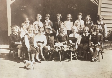
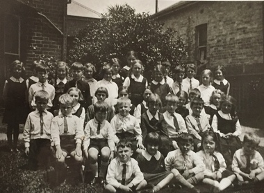
Photograph - Clarence Kindergarten and Sub-Primary, 180 Cotham Road, 1930-1935
... 180 Cotham Road -- kew (vic.)... (Vic.) Clarence school Clarence house 180 Cotham Road -- kew ...180 Cotham Road, formerly 178 and later 210 Cotham Road, described as a brick residence of six rooms, was constructed in c.1890, for Alexander Hall, a dentist. From 1903, Miss Florrie Wymond operated a girls school at the property, and a timber schoolroom building was constructed at the rear of the property. During the 1930s, the school was known as the Clarence Primary School, and operated by Misses F L and M Wymond. While the listing of the property as a primary school had ceased by 1947, the Wymond family owned the property until the mid 1960s. (Source: Lovell Chen 2007, Review of B-graded buildings in Kew, Camberwell and Hawthorn).One of three photographs taken between 1930 and 1935 of students of 'Clarence' Kindergarten and Sub-Primary, located at 180 Cotham Road. The photos were accompanied by detailed notes identifying the names of students (where remembered).schools -- kew (vic.), clarence school, clarence house, 180 cotham road -- kew (vic.) -
 Kew Historical Society Inc
Photograph - Clarence Kindergarten and Sub-Primary, 180 Cotham Road, 1930-1935
... 180 cotham road -- kew (vic.)... (vic.) clarence school clarence house 180 cotham road -- kew ...180 Cotham Road, formerly 178 and later 210 Cotham Road, described as a brick residence of six rooms, was constructed in c.1890, for Alexander Hall, a dentist. From 1903, Miss Florrie Wymond operated a girls school at the property, and a timber schoolroom building was constructed at the rear of the property. During the 1930s, the school was known as the Clarence Primary School, and operated by Misses F L and M Wymond. While the listing of the property as a primary school had ceased by 1947, the Wymond family owned the property until the mid 1960s. (Source: Lovell Chen 2007, Review of B-graded buildings in Kew, Camberwell and Hawthorn).One of three photographs taken between 1930 and 1935 of students of 'Clarence' Kindergarten and Sub-Primary, located at 180 Cotham Road. The photos were accompanied by detailed notes identifying the names of students (where remembered).schools -- kew (vic.), clarence school, clarence house, 180 cotham road -- kew (vic.) -
 Kew Historical Society Inc
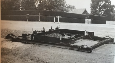
Photograph - Street Works, Studley Park Road, March 1934
... studley park road -- kew (vic.)....) studley park road -- kew (vic.) city of kew -- engineers ...Studley Park Road, like most streets in Kew, was originally a dirt road. Street works during the Great Depression included bituminising major roads in the district. This photograph of Council works originated in the City of Kew Engineers Department as a record of works undertaken. It was given to the collection by a Mrs Fisher in 1998.Well provenanced photograph of Council-funded public works in Kew during the Great Depression. Original sepia photographic positive of a drag used to spread bitumen in Studley Park Road, Kew.Typed reverse: "B4 / Kew C.C. / Drag spreader used for premixed material on Studley Park Road, showing end of strip just with spread, with unsurfaced work on left and completed section on right, March 1934"roadworks -- kew (vic.), street works -- kew (vic.), public works kew (vic.), studley park road -- kew (vic.), city of kew -- engineers department, city of kew -- public works -- great depression -- 1930s -
 Kew Historical Society Inc
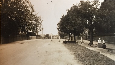
Photograph - Street Works, Studley Park Road, March 1934
... studley park road -- kew (vic.)....) studley park road -- kew (vic.) city of kew -- engineers ...Studley Park Road, like most streets in Kew, was originally a dirt road. Street works during the Great Depression included bituminising major roads in the district. This photograph of Council works originated in the City of Kew Engineers Department as a record of works undertaken. It was given to the collection by a Mrs Fisher in 1998.Well provenanced photograph of Council-funded public works in Kew during the Great Depression. Original sepia photographic positive of Studley Park Road, Kew while resurfacing of the street was taking place. The Kew Junction is just visible in the distance. Boys sitting on a drum at right. Behind them is the brick fence and front entrance to Tara Hall.Typed reverse: "B4 / Kew C.C. / Studley Park Road showing drag spread surfacing with premixed material, unrolled material on the right, March 1934"roadworks -- kew (vic.), street works -- kew (vic.), public works kew (vic.), studley park road -- kew (vic.), city of kew -- engineers department, city of kew -- public works -- great depression -- 1930s -
 Kew Historical Society Inc
Photograph - Street Works, Studley Park Road, March 1934
... studley park road -- kew (vic.)....) studley park road -- kew (vic.) city of kew -- engineers ...Studley Park Road, like most streets in Kew, was originally a dirt road. Street works during the Great Depression included bituminising major roads in the district. This photograph of Council works originated in the City of Kew Engineers Department as a record of works undertaken. It was given to the collection by a Mrs Fisher in 1998.Well provenanced photograph of Council-funded public works in Kew during the Great Depression. Original sepia photographic positive of Studley Park Road, Kew while resurfacing of the street was taking place. Typed reverse: "B4 / Kew C.C. / Spreading premixed material on Studley Park Road with drag spreader, March 1934"roadworks -- kew (vic.), street works -- kew (vic.), public works kew (vic.), studley park road -- kew (vic.), city of kew -- engineers department, city of kew -- public works -- great depression -- 1930s -
 Kew Historical Society Inc
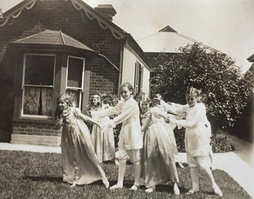
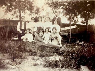
Photograph - Bennett Family Gathering, 22 Harp Road, c.1910
In 1980, Mr Laurie Bennett presented the Kew Historical Society with a number of photographs and postcards from the estate of his mother Eileen Mary Bennett (nee Clark). His mother was the daughter of Lawrence FH Clark(?-1946) and Mary Clark (?-1925) of 22 Harp Road, East Kew, in whose yard the photograph was taken. A year before the donation occurred a notice appeared in the Canberra Times stating that: "BENNETT, Eileen Mary. — May 8th at Tuross Heads, N.S.W. Late of 22 Harp Rd, East Kew, (Vic). Dearly loved wife of the late Harold Bennett, loved mother and mother in law of Laurie and Shirley (Melbourne), Kevin and Doreen (Canberra), grandmother of Linda, Stephen, Paul, Gabrielle, Peter, Mark and Jon."Part of a large collection of photographs and postcards in the collectionFamily portrait of members of the Bennett family of 22 Harp Road, East Kew. laurie bennett, eileen mary bennett, eileen mary clark -
 Kew Historical Society Inc
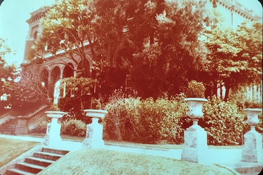
Photograph - 'Raheen', 96 Studley Park Road, c.1980
... raheen -- 96 studley park road -- kew (vic.).... (source VHD) raheen -- 96 studley park road -- kew (vic.) historic ...Raheen was constructed as a two-storey house in the Italianate style with a four-storey tower over the entrance and single-storey extension. It was designed in an asymmetric and arcaded form, and is built of red brick with cement render. The property retains its garden layout, including an Italianate garden, outbuildings, fence and gates, and internal features including the original stairwell, library, ballroom and cast iron tower stairs. (source VHD)View of the upper and lower eastern loggias of 'Raheen' at 96 Studley Park Road, Kew from the eastern garden. The colour photo shows the pedestals and urns above the steps and the plantings in the garden c.1980. raheen -- 96 studley park road -- kew (vic.), historic houses -- studley park, mansions -- kew (vic.) -
 Kew Historical Society Inc
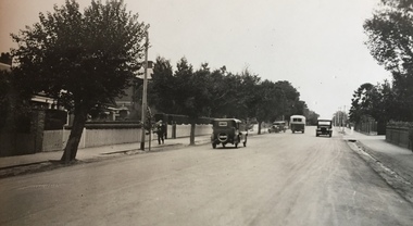
Photograph - High Street, Kew East, 1916
In 1980, Mr Laurie Bennett presented the Kew Historical Society with a number of photographs and postcards from the estate of his mother Eileen Mary Bennett (nee Clark). His mother was the daughter of Lawrence FH Clark(?-1946) and Mary Clark (?-1925) of 22 Harp Road, East Kew, in whose yard the photograph was taken. A year before the donation occurred a notice appeared in the Canberra Times stating that: "BENNETT, Eileen Mary. — May 8th at Tuross Heads, N.S.W. Late of 22 Harp Rd, East Kew, (Vic). Dearly loved wife of the late Harold Bennett, loved mother and mother in law of Laurie and Shirley (Melbourne), Kevin and Doreen (Canberra), grandmother of Linda, Stephen, Paul, Gabrielle, Peter, Mark and Jon."Part of a large collection of photographs and postcards in the collection. This dated photograph allows the researcher to identify development by 1916 in Kew and East Kew.High Street, Kew East in 1916 looking west. "High Street, East kew, near rail bridge."laurie bennett, eileen mary bennett, eileen mary clark -
 Kew Historical Society Inc
Photograph - Yarra in Flood - Belford & Kilby Farms, 1903
In 1980, Mr Laurie Bennett presented the Kew Historical Society with a number of photographs and postcards from the estate of his mother Eileen Mary Bennett (nee Clark). His mother was the daughter of Lawrence FH Clark(?-1946) and Mary Clark (?-1925) of 22 Harp Road, East Kew, in whose yard the photograph was taken. A year before the donation occurred a notice appeared in the Canberra Times stating that: "BENNETT, Eileen Mary. — May 8th at Tuross Heads, N.S.W. Late of 22 Harp Rd, East Kew, (Vic). Dearly loved wife of the late Harold Bennett, loved mother and mother in law of Laurie and Shirley (Melbourne), Kevin and Doreen (Canberra), grandmother of Linda, Stephen, Paul, Gabrielle, Peter, Mark and Jon."Part of a large collection of photographs and postcards in the collectionPanoramic photographic positive of North Kew where the Belford and Kilby Farms were located on the south side of the Yarra River. This photo, donated in 1980 by Laurie Bennett is the original of the two identical photos in the collection.laurie bennett, eileen mary bennett, eileen mary clark, floods -- yarra -- 1903 -
 Kew Historical Society Inc
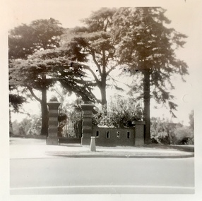
Photograph - Gates of 'Raheen', Studley Park Road, 1981
... raheen -- studley park road -- kew (vic.)... residence. (Source: VHD) raheen -- studley park road -- kew (vic ...The first section of Raheen was commenced in 1870 with an extension added in 1884. It was designed by William Salway and built for Edward Latham of the Carlton Brewery. Sir Henry Wrixon, prominent Melbourne barrister and solicitor, later owned and resided at the property. In 1917 Raheen was purchased by the Catholic Church and became the official residence of Archbishop Mannix, as well as four other Catholic archbishops of Melbourne. In 1981 the Church sold the property and it again reverted to a private residence. (Source: VHD)Photographic positive showing the gates to the mansion 'Raheen' in Studley Park Road. Notable are the three Himalayan Cedars inside and outside the high brick fence.Verso: "Gates to Raheen 1981"raheen -- studley park road -- kew (vic.), mansions -- studley park -- kew (vic.), historic houses -- studley park -- kew (vic.), raheen -
 Kew Historical Society Inc
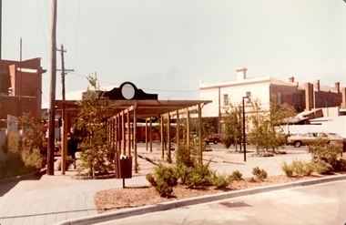
Photograph - Street Beautification: Port Melbourne, 1980s
The City Engineer's Department within the former City of Kew, was responsible for public works, including street beautification. This photograph was held in the archives of the Department and was subsequently gifted to the Kew Historical Society. Like other examples originally held by the Department, photographs of road works, street beautification, engineering works were often sourced from other municipalities, or countries, to use as references for engineering works and design in Kew.Colour photographic positive (faded) of street beautification in Port Melbourne, used as a model by the Engineer's Department of the City of Kew for how civic spaces, including shopping centre precincts, could be improved. street beautification, city of kew -- engineers department, public works -- kew (vic.), port melbourne -
 Kew Historical Society Inc
Photograph - Yarra Valley Floods: Kew East, 1916
... kilby road -- kew (vic.).... yarra river yarra valley floods -- kew kilby road -- kew (vic ...Flooding of the Yarra Valley, including that section of the Yarra bordering Kew and Kew East in the north and west of the municipality, was a regular occurrence. Extreme flood events of the Yarra River are recorded to have occurred in 1891, 1901, 1916, 1923 and 1934. The Municipality of Kew's response to these floods was to enact planning decisions restricting residential development in flood prone areas following the floods of 1916, 1921 and 1934. While floods continued after the development of the Upper Yarra Reservoir (construction 1948-57), the regularity and extent of these inundations diminished. During the nineteenth century, the land abutting the south side of the Yarra in Kew was devoted to dairy farming. In the twentieth century, before and after the construction of the Eastern Freeway, much of this low-lying area was used as golf courses and public parks.One of a collection of photographs of flooding in the Kew section of the Yarra Valley which are in important research resource for the location and extent of flooding in the first half of the twentieth century. Flooding of the Yarra Valley at East Kew in 1916. The view is taken from the intersection of Kilby Road with what is believed to be Birdwood Street, looking across the flood waters to Ivanhoe. The extensive flooded area shown in the photograph would have included the Kew Golf Club. Verso: "Floods along Kilby Road / near Birdwood St? & Kilby Road / 1917? / 87yarra river, yarra valley, floods -- kew, kilby road -- kew (vic.), kew golf club -
 Kew Historical Society Inc
Photograph - Yarra Valley Floods: Kew East, 1916
... kilby road -- kew (vic.)... floods -- kew kilby road -- kew (vic.) kew golf club ...Flooding of the Yarra Valley, including that section of the Yarra bordering Kew and Kew East in the north and west of the municipality, was a regular occurrence. Extreme flood events of the Yarra River are recorded to have occurred in 1891, 1901, 1916, 1923 and 1934. The Municipality of Kew's response to these floods was to enact planning decisions restricting residential development in flood prone areas following the floods of 1916, 1921 and 1934. While floods continued after the development of the Upper Yarra Reservoir (construction 1948-57), the regularity and extent of these inundations diminished. During the nineteenth century, the land abutting the south side of the Yarra in Kew was devoted to dairy farming. In the twentieth century, before and after the construction of the Eastern Freeway, much of this low-lying area was used as golf courses and public parks.One of a collection of photographs of flooding in the Kew section of the Yarra Valley which are in important research resource for the location and extent of flooding in the first half of the twentieth century. Flooding of the Yarra Valley at East Kew in 1916. The view is taken from a street (maybe Birdwood Avenue) intersecting with Kilby Road looking northeast across the flood waters to Ivanhoe and Heidelberg. The extensive flooded area shown in the photograph would have included remnant dairy farms and the Kew Golf Club. Verso: "Floods / Yarra River / East Kew / Kilby Road / 1917? / 87"yarra river, yarra valley, floods -- kew, kilby road -- kew (vic.), kew golf club -
 Kew Historical Society Inc
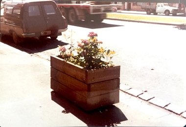
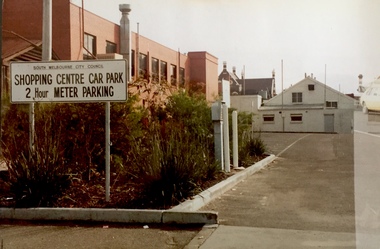
Photograph - Carpark: South Melbourne, 1980s
The City Engineer's Department within the former City of Kew, was responsible for public works, including street beautification. This photograph was held in the archives of the Department and was subsequently gifted to the Kew Historical Society. Like other examples originally held by the Department, photographs of road works, street beautification, engineering works were often sourced from other municipalities, or countries, to use as references for engineering works and design in Kew.Colour photographic positive (faded) of public parking in South Melbourne, perhaps used as a model by the Engineer's Department of the City of Kew for how civic spaces, including shopping centre precincts, could be improved. city of kew -- engineers department, public works -- kew (vic.), south melbourne, carparks, signs -
 Kew Historical Society Inc
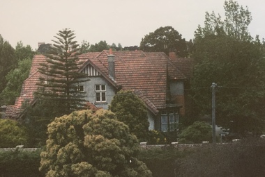
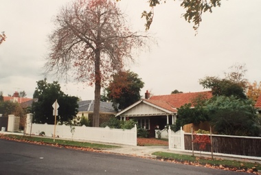
Photograph - 227 Cotham Road, Kew, 1988
... houses -- cotham road -- kew (vic.)... of a house at 227 Cotham Road, Kew houses -- cotham road -- kew (vic ...Colour photographic positive of a house at 227 Cotham Road, Kewhouses -- cotham road -- kew (vic.), 227 cotham road -- kew (vic.) -
 Kew Historical Society Inc
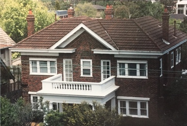
Photograph - 264 Cotham Road, 1988
... 264 cotham road -- kew (vic.)...) (Boroondara Planning Scheme) 264 cotham road -- kew (vic.) ...The dwelling is representative of the development of the Georgian Revival style in the 1920s and 30s and its popularity amongst the upper-middle classes as a result of the work of William Hardy Wilson and Professor Leslie Wilkinson. It is of importance as a fine and largely intact designer/builder example of the Georgian Revival style, with American Georgian Revival influences. The dwelling embodies the principal characteristics of the style. American Georgian Revival influences are noted in the deep eaves with modillions, central broken pediment, brick quoins and presentation of the central porch. The garden wall, with arched opening, in the side setback appears to be an early or original landscape feature, based on the comparable brick work detail construction with that of the house. Considering this, it is the only early landscape feature extant which assists in providing some understanding of the original landscape layout of the property. (Criteria D and E) (Boroondara Planning Scheme)Colour photographic positive of 264 Cotham Road, Kew. The residence was constructed in 1931 for the Howitt family. 264 Cotham Road, Kew (HO813) is an individually listed building of significance under Amendment C294 of the Boroondara Planning Scheme. 264 cotham road -- kew (vic.) -
 Kew Historical Society Inc
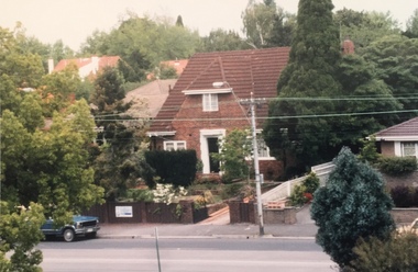
Photograph - 306 Cotham Road, 1988
... 306 cotham road -- kew (vic.)... Road, Kew. 306 cotham road -- kew (vic.) ...Colour photographic positive of 306 Cotham Road, Kew. 306 cotham road -- kew (vic.) -
 Kew Historical Society Inc
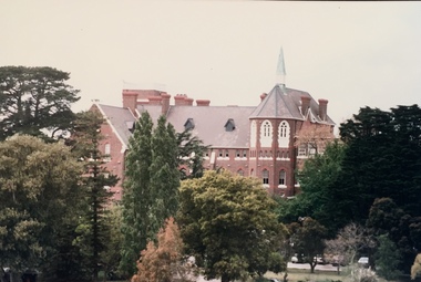
Photograph - Genazzano FCJ College, 285-315 Cotham Road, 1988
Construction of Genazzano FCJ College began in 1880 to designs by William Wardell. The College is registered on the Victorian Heritage Register.Colour photographic positive of Genazzano FCJ College, 285-315 Cotham Road, Kew. genazzano fcj college -- kew (vic.), william wardell, schools -- kew (vic.) -
 Kew Historical Society Inc
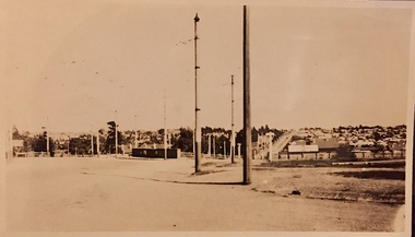
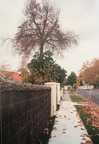
Photograph - Carson Street, Kew, 1993
A series of five photographs of streetscapes in Kew in 1993, of which this is one, focus on footpaths and gutters, so while the provenance is uncertain, it is presumed that they were created in the office of City Engineer in the City of Kew.Colour positive print of Carson Street, which runs between Studley Park Road and Findon Crescent, dating from 1993carson street -- kew (vic.) -
 Kew Historical Society Inc
Photograph - Carson Street, Kew, 1993
A series of five photographs of streetscapes in Kew in 1993, of which this is one, focus on footpaths and gutters, so while the provenance is uncertain, it is presumed that they were created in the office of City Engineer in the City of Kew.Colour positive print of Carson Street in Kew, dating from 1993. Carson Street runs between Studley Park Road and Findon Crescent.carson street -- kew (vic.) -
 Kew Historical Society Inc
Photograph - The Boulevard at Kew, 1937
... roads -- kew (vic.)... by the Victorian Government. great depression susso projects roads -- kew ...The Yarra Scenic Boulevard stretching from Hawthorn to the Chandler Highway was completed as a major project between 1933 and 1936 during a period of significant unemployment. Key dates in the construction this section the road include: 1933 when Kew Council supported the construction of the road from Studley Park to the Kew Asylum; and 1936 when the road from the Johnston Street Bridge to the Chandler Highway was opened. The inscription on the reverse of the photo 'Boulevard Fairfield' is misleading as there is no section of the Boulevard in Fairfield. A more likely interpretation is that it is a photograph of the Kew section of the Yarra Boulevard with the factories of Fairfield in the distance.Rare early photograph of the Yarra Boulevard, taken one year after the opening of the road. The photograph is an important historical record of the results of 'Susso' labor in the creation of major works in Melbourne by the Victorian Government. Original, black and white positive print of the Boulevard at Kew in 1937. Key aspects to note about the photograph is that the road is bituminised; that the gutters are concreted; that the kerb is constructed of concrete blocks; and that there is an unmade footpath on what appears to be the right hand side of the road. The landscape is sparsely treed, and those trees that remain are presumably remnant vegetation. At the right, the land is fenced. The land at the left falls away sharply to the river below. On the horizon, at left, there is an industrial complex including a tall chimney that is burning fuel creating smoke. "Boulevard Fairfield" great depression, susso projects, roads -- kew (vic.), yarra boulevard, yarra valley -
 Kew Historical Society Inc
Photograph - Studley Park, 1937
... mansions, largely located along the main roads. studley park -- kew ...Those sections of Studley Park closest to the River Yarra were set aside as parkland in the 1850s. After initial discussions about whether it was a suitable site for a Government House, much of the land was instead gazetted in the 1860s as the location for a new lunatic asylum, to expand overcrowded mental health facilities at the Yarra Bend Asylum on the other side of the river at Fairfield. Those sections of Studley Park bounded by the Yarra River, Studley Park Road, Princess Street and Fellows Street were subdivided and sold at the Crown Land Sales in 1851. Much of this urban area remained open farmland until the twentieth century, apart from mansions, largely located along the main roads.Original, black and white positive print of what is said to represent Studley Park in 1937. If the attribution and date is literally to be understood, then it would appear that the photograph may have been taken from the Kew side of the river looking across to open farmland in the Yarra Bend Park. If the designation of Studley Park is to be understood more loosely, then it might be a view of what is now East Kew, taken from a section of Kilby Road. Inscribed verso: "Studley Park 1937" studley park -- kew (vic.) -
 Kew Historical Society Inc
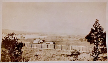
Photograph - Yarra Flats near Burke Road Bridge, 1937
Land along the Yarra River in Kew is now either designated open space, parkland or public golf links. By the 1930s much of this area remained open farmland, bought at auction for dairy farming in the 1840s.Original, black and white positive print of what is said to be the Yarra Flats near Burke Road Bridge. On the horizon, building can be seen, whereas in the middle ground, farm fencing and a windmill are the main features as well as remnant Eucalypts. Inscribed verso: "Yarra Flats near Burke Rd Bridge 1937" studley park -- kew (vic.) -
 Kew Historical Society Inc
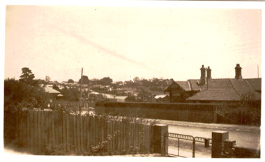
Photograph - Corner of Normanby and Parkhill Roads, Kew, 1926
... normanby road -- kew (vic.)... Rds corner " normanby road -- kew (vic.) parkhill road -- kew ...Original, black and white positive print of a photograph taken from the garden of a house in Myrtle Avenue across the road to another house on the corner of Normanby and Parkhill Roads. The hills of Kew can be seen in the background. The main house in the photo is 56 Normanby Road.Inscribed verso: "Normanby Rds and Parkhill Rds corner " normanby road -- kew (vic.), parkhill road -- kew (vic.), myrtle avenue -- kew (vic.), 56 normanby road -- kew (vic.)