Showing 2472 items
matching map of victoria
-
 Ringwood and District Historical Society
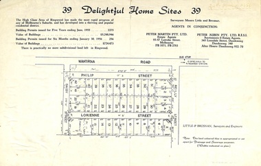
Flyer, Subdivision advertisement for sale of home sites - Ringwood, Victoria - 1956
Cardboard-backed advertisement for 39 home sites for sale, with location map, and summary of local real estate statistics in 1955 & 1956. Handwritten date noted in top right corner - 24th March, 1956.Subdivision map includes Reilly Street, Philip Street, Lorienne Street and Daisy Street in Heathmont. Surveyors: Messrs Little and Brosnan. Agents in conjunction: Peter Martin Pty. Ltd., Estate Agents, 55-57 Latrobe Street, Melbourne (Phone) FB 3571, FB 2783, and Peter Aubin Pty. Ltd., Auctioneers & Estage Agents, 345 Lonsdale Street, Dandenong (Phone) Dandenong 340, after hours Dandenong 932, 70. -
 Ringwood and District Historical Society
Flyer, Land Sale Advertisement - State School Estate, Ringwood, Victoria - 1923
The date of the flyer as circa 1920 can be estimated from the references to the (decision on) "electrification of the Croydon Railway Line" which eventually occurred in 1923, letting of tenders for the state school building which opened in 1924, and the "proposed new railway station" (East Ringwood) which opened in 1925, Advertisement for State School Estate, Ringwood - 26 residential allotments for sale near East Ringwood State School development site and 7 minutes walk from proposed new railway station (East Ringwood). Includes location map and terms of sale.Locality plan includes King Street and Government Roads (Later Everard Road, Holland Road, Purser Avenue, and Charles Street). (Agents) J.B. McAlpin, Estate Agent and Subdivisional Manager, Ringwood (Opposite Station), and F.V. Parker, Estate Agent, Main Street, Ringwood. -
 Ringwood and District Historical Society
Flyer, Auction Sale Advertisement - Ringwood Station Estate, Ringwood, Victoria - 1919
Folded double-sided brochure advertising auction of residential allotments on Saturday, 11 October, 1919, with town photographs including residence of Mr. and Mrs. Williams on the estate, location map, terms of sale, and summary of local features and services.Subdivision includes Bedford Road and Williams Grove (later Lena Grove). (Agents) Knight & Harwood, 315 Collins Street, Melbourne, Phones Central 10615, 10616, in conjunction with Godbehear & Co., Local Agents, Ringwood, Phone Ringwood 49. -
 Ringwood and District Historical Society
Flyer, Land Sale Advertisement - East Ringwood Township Estates, East Ringwood, Victoria - circa 1920
The date of the flyer as circa 1920 can be estimated from the references to the (decision on) "electrification of the Croydon Railway Line" which eventually occurred in 1923, letting of tenders for the state school building which opened in 1924, and the "proposed new railway station" (East Ringwood) which opened in 1925, Advertisement for three retail and residential allotment land sales in East Ringwood Township including maps showing layout of subdivisions. Township Estate, State School Estate, and East Ringwood Station Estate.Subdivision plans include Mount Dandenong Road, Grey Street, Eastfield Road, King Street, Everard Road, Holland Road, Purser Avenue, and Charles Street. (Agents) Spencer Jackson, Subdivider & Homebuilder, 341 Collins Street, Melbourne, Phones: M2327 (3 lines), also at Dromana, Phone 65. -
 Ringwood and District Historical Society
Flyer, Land Sale Advertisement - Roebury Estate, Ringwood, Victoria - circa 1938
Advertisement for sale of residential allotments with map showing location and layout of subdivision, terms of sale, and summary of local features and services.Subdivision includes Dublin Road, Alexander Road, and Ferntree Gully Road (later Bedford Road). Agent - J.B. McAlpin, Opposite Railway Station, Ringwood. -
 Ringwood and District Historical Society
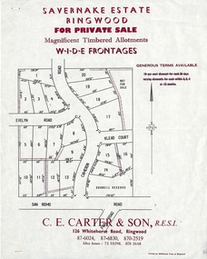
Flyer, Land Sale Advertisement - Savernake Estate, Ringwood, Victoria - 1967
Advertisement for sale of residential allotments with map showing layout of subdivision in North Ringwood, with typewritten pricelist attached outlining suggested terms of sale as of 14 September, 1967.Subdivision includes Evelyn Road, Cameron Road, Klead Court, and San Remo Road. Agent - C.E. Carter & Son., 126 Whitehorse Road, Ringwood. (Phone) 87-6024, 87-6830, 870-2519, After hours: 723 3298, 878 2648. -
 Ringwood and District Historical Society
Flyer, Land Sale Advertisement - Sunbeam Estate, East Ringwood, Victoria - circa 1930
Folded double-sided page advertising private sale of 48 residential allotments, with location map, terms of sale, and details of local features and services. Locality plan includes Holland Road, Everard Road, Sunbeam Avenue, Mount Dandenong Road, and Lilydale Road (later Old Lilydale Road). (Agents) Phillips & Nicholson, 59 Swanston Street, Melbourne, (Phone) Central 10907, in conjunction with C.E. Carter, Bank Chambers, Main Street, Ringwood, Telephone Ringwood 24. -
 Ringwood and District Historical Society
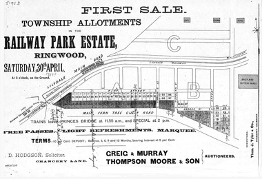
Flyer, Subdivision advertisement - Railway Park Estate, Ringwood, Victoria - circa 1887
Photocopy of advertisement for auction sale of township allotments in Railway Park Estate, Ringwood, on Saturday 30th April (1887?), with terms of sale and location map.Subdivision map includes Pitt Street and Main Ferntree Gully Road (later Bedford Road). (Agents) Greig & Murray, Thompson Moore & Son, Auctioneers. -
 Ringwood and District Historical Society
Flyer, Land Sale Advertisement and auction notice - Range View Estate, Ringwood, Victoria - 1920
Advertisement for sale of 150 residential allotments with terms of sale, summary of local features and services, and map showing location and layout of subdivision within the boundary of Mitcham to the west of Ringwood, Victoria. Copy of newspaper advertisement (The Herald, Melbourne, Wednesday 3 March, 1920) refers to public auction date for Range View Estate Ringwood - Saturday, 27th March, 1920.Subdivision includes Deep Creek Road, Range View Grove, Warnes Road, Tarrangower Avenue, Prince Edward Avenue, James Avenue, and White Horse Road, Mitcham. Agents - Phillips & Nicholson, 281 Collins Street, Melbourne, Telephone Central 10907. -
 Ringwood and District Historical Society
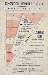
Flyer, Land Auction Sale Advertisement - Ringwood Heights Estate, Ringwood, Victoria - circa 1923
Advertisement for land and weatherboard villa auction sale on Saturday, January 13 (1923?) - Ringwood Heights Estate, corner Warrandyte and Wonga Roads, North Ringwood, with terms of sale, summary of local features and services, and map showing layout of subdivisionSubdivision includes Wonga Road and Anderson's Creek Road (later Warrandyte Road). Agents - Sydney T. Haynes & Co., Auctioneers, 60 Queen Street, Melbourne. Phone Central 3400; J.B. McAlpin, Estate Agent, Opposite Ringwood Station. Auction in the Trust Estate of J.J. Parker, instructed by the Equity Trustees Co. Ltd. 85 Queen Street, Melbourne. -
 Ringwood and District Historical Society
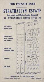
Flyer, Land Sale Advertisement - Strathallyn Estate, Ringwood, Victoria - circa 1950
Advertisement for private sale of 36 home sites in the Warrandyte Road and Mullum Mullum Road area of Ringwood, with map showing layout of subdivision and summary of local features and services. Handwritten notation indicates May, 1950.Subdivision includes Warrandyte Road, Strathallyn Road, Norman Court, Lade Court, and Mullum Mullum Road. Agents: A.T. Miles & Son, 175 Main Street, Ringwood, Phone WU6215. -
 Ringwood and District Historical Society
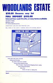
Flyer, Land Sale Advertisement - Woodlands Estate, North Ringwood, Victoria - circa 1970
Double sided single-page advertisement for land sale with locality map and layout of Woodlands Estate subdivision in North Ringwood, with summary of local features and services. No indication of date of flyer other than post-Eastland Shopping Centre opening in 1967.Subdivision includes Oban Road, Terrigal Close, Dorelaw Drive (later Melview Drive), Naroo Court, and Barook Court. Agent's rubber stamp imprint - H.C. Walton & Son, 264 Doncaster Road, North Balwyn. -
 Ringwood and District Historical Society
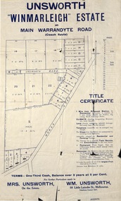
Flyer, Land Sale Advertisement - Unsworth Winmarleigh Estate, Ringwood, Victoria - circa 1912
Advertisement and attachment for subdivision of land adjoining Warrandyte Road coach route in North Ringwood, with map showing layout of subdivision, summary of local features and services, and terms of sale. Subdivision includes Wonga Road (later Loughnan Road & Warrandyte Road), Unsworth Road, Through Road, Cross Street, and John Street. Contacts - Mrs Unsworth on the Estate or W.M. Unsworth, 58 Little Latrobe Street, Melbourne, Telephone Central 7207. -
 Ringwood and District Historical Society
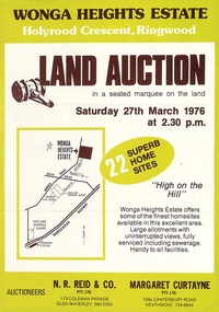
Flyer, Land Auction Advertisement - Wonga Heights Estate, North Ringwood, Victoria - 1976
Double-sided printed page advertising land auction on Saturday 27th March, 1976, with locality map and subdivision layout, terms of sale, and summary of local features and services. Subdivision includes Wonga Road, Holyrood Crescent, Georgian Court, and Stonnington Place. Auctioneers - N.R. Reid & Co. Pty. Ltd., 173 Coleman Parade, Glen Waverley (Telephone) 560 0355, and Margaret Curtayne Pty. Ltd., 109a Canterbury Road, Heathmont (Telephone) 729 6844. -
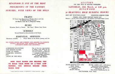 Ringwood and District Historical Society
Flyer, Land Auction Advertisement adjoining Jubilee Park, Ringwood, Victoria - 1956
Folded double-sided brochure advertising residential land sale auction on Saturday 24th March (1956), with locality map and subdivision layout, terms of sale, and summary of local features and services. Subdivision includes Reilly Street Ringwood, and Philip Street, Daisy Street, and Lorienne Street Heathmont. Surveyors - Messrs Little and Brosnan. Agents in Conjunction - Peter Martin Pty. Ltd., Estate Agents, 55-57 Latrobe Street, Melbourne (Phone) FB 3571, FB 2783, and Peter Aubin Pty. Ltd. R.E.S.I., Auctioneers & Estate Agents, 345 Lonsdale Street, Dandenong (Phone) Dandenong 340, After Hours, Dandenong 932, 70. -
 Ringwood and District Historical Society
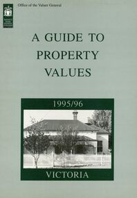
Book - Collection, Valuer General of Victoria, Guide to Property values in Victoria 1988-2006 (16 volumes), 1988-2004
part of the Richard Carter CollectionCollection of 16 books from the Office of the Valuer general with data and analysis of property values in Victoria by City and by Shire. With maps of local government. 1988-1994 A4 in size reducing to a slightly smaller size 1996-2006. Originals not kept - only scanned pages of City of Ringwood and Maroondah City Council PDFed. Refer to Victorian Government websites (www.land.vic.gov.au, www.consumer.vic.gov.au and others for Excel downloads and further details. -
 Ringwood and District Historical Society
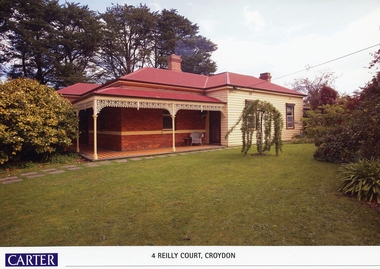
Memorabilia, History of Kleinert's Homestead, 4 Reilly Court, Croydon, Victoria
Collection of maps and title deeds of Kleinert's 1886 homestead - 22 pages in pockets in black plastic spiral binder, compiled by Richard Carter, November 2008. Photocopies of title deeds and subdivisions. -
 Ringwood and District Historical Society
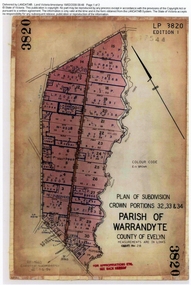
Document, Titles of land subdivision, Crown Portions 32, 33 & 34, Parish of Warrandyte, 1884 and 1907, Ringwood, Victoria
Evolution of the subdivision and the use of landBlack plastic bound pockets containing copies of 18 LANDATA subdivision maps and mortgage transfer pages dating from 1884 for 303 acres 2 roods and 1 perch bounded by Warrandyte Road, Wonga Road, Oban Road and Mullum Mullum Creek in Ringwood, Victoria. Certificates of Title include Vol 1606 Fol 045 Frederick Walter Purches 1884 and subsequent transfers to 1902, and Vol 3232 Fol 646357 Ann Jane Kennedy 1907 and transfers to 1921. -
 Ringwood and District Historical Society
Document - Extract from book "Bush Town to City" (Croydon, Victoria), Severance from the Shire of Lillydale 1952-1961
Addendum to folder of Estate Agent's notes compiled in preparation for property auction, "Shadowood", 74-76 Alto Avenue, Croydon, Victoria, 11th October, 2008. Ten pages plus map detailing the history of the severance of Croydon from Lillydale written by Robert Federick Jensen. -
 Ringwood and District Historical Society
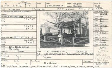
Document, Property profile for sale of house and land, 4 Melbourne Street, Ringwood, Victoria - 1960
The house was owned by Mrs. Jessie White 4, Melbourne St. on the corner of Miles Ave. now both lost in the development of Eastland Shopping Centre.Details include map reference, dimensions of land and living space, picture of house, details of local services. Owner/Occupier Mr. Whiter. Agent J.B. Thomson & Co., 129 Springvale Road, Nunawading. -
 Ringwood and District Historical Society
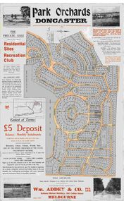
Map, Park Orchards Land Sale Advertisement, Doncaster, Victoria, Circa 1926
... Avenue, Park Road. Large linen backed map of the Park Orchards ...Large linen backed map of the Park Orchards subdivision for private sale of residential sites and recreation club, highlighting local facilities, services and layout of the estate. Surveyors - Tuxen & Miller, 34 Queen Street, Melbourne. Agents - Wm Addey & Co., Pty Ltd., National Mutual Buildings, 395 Collins Street, Melbourne, Phone F3906. Terms £5 deposit balance monthly installments of £1 with the residue at the end of five years. Subdivision includes Alva Avenue, Arundel Road, Aviemore Avenue, Berringa Road, Bowmore Avenue, Brucedale Crescent, Brympton Avenue, Camber Avenue, Cawdor Avenue, Colin Avenue, Corriedale Crescent, Craithie Avenue, Daintree Avenue, Dalry Avenue, Dirlton Crescent, Drayton Crescent, Elgin Crescent, Enfield Avenue, Ennismore Crescent, Euston Avenue, Feversham Avenue, Frogmore Crescent, Gosford Crescent, Granard Avenue, Hopetoun Road, Hylton Avenue (later Knees Road), Jura Avenue, Park Road. -
 Orbost & District Historical Society
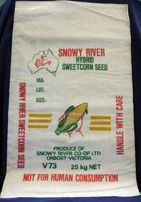
seed bag
This unused bag would have been used by Snowy River Co-Op Ltd to pack sweet corn in the late 1960's -1980's Snowy River Seeds started life as a farmers' co-operative (Snowy River Co-op) in 1967 specialising in horticulture. Snowy River Co-op were the original creators of Snowy Seeds.This item is significant because it was specially made for the seed bean industry which is a major industry in the Orbost district.A white synthetic woven fibre bag used to pack sweet corn prior to sale. It has red, green, yellow print.On front of bag - Logo of Man From Snowy River in outline map of Australia with a hand holding corn cob in the centre, Produce of Snowy River Co-Op Ltd Orbost- Victoria V73 25kg NETsweet-corn seed-bags snowy-river-co-op -
 Ringwood and District Historical Society
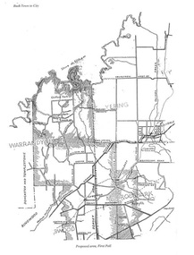
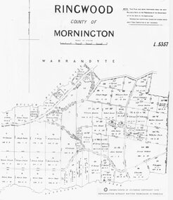
Photograph, Parish map of Ringwood, County of Mornington - 1878
... "Crown (State of Victoria) Copyright 1973" Parish map of Ringwood ...Copyright note states "Crown (State of Victoria) Copyright 1973"Written on backing sheet, "SLV Parish Map Collection Vol.23, Fol.64". -
 Orbost & District Historical Society
survey sheet, circa 1870's
E.L. Bruce, born in Ireland on July 1,1854, came to Australia in 1854 and joined the Lands Department. He spent most of his service in Gippsland. The journey to Sale then was made by ship to Port Albert and thence on horseback. He began his service in Gippsland as assistant district surveyor and for the last 12 years before retirement he was district surveyor and land officer. His territory extended from the boundary of Victoria in east Gippsland down to Wilson's Promontory with his headquarters at sale.This map is a useful reference tool.A survey map - Sheet No 3 SnowyRiver Survey. This is a copy of the original survey. It shows the properties of W.J.T. Clarke - two in Orbost and one in Newmeralla (sic),. it has a faded, undecipherable red stamp in the bottom right corner.Gipps Land Rivers No 32B E.L. Brucesurvey bruce-e.l snowy-river-c19th -
 Orbost & District Historical Society
book, Vic Roads Centenary 1913 -2013, 2013
The publication, VicRoads Centenary: Keeping Victorians Connected for 100 Years, looks at the people and projects that define VicRoads’ history. Written by current and former VicRoads’ employees, the publication details the organisation’s portfolio of major projects, which includes the Great Ocean Road, Hume Highway and Eastern Freeway. Other sections report on Victoria’s world-first road safety initiatives, VicRoads’ use of technology and sustainability measures. (ref VicRoads) This item is one of several books donated by David Jellie at a presentation to Orbost Historical Society. He was a contributor to the book and was the engineer for the Snowy River Bridge (Princes Highway) at Orbost 1974-1976.This book is a useful reference tool on the history of road construction in Victoria including East Gippsland.A thick, bound paperback book, titled "VicRoads Centenary Keeping Victorians Connected for 100 Years". On the front cover is a black/white photograph of two men working on a road. One has a pick. The book contains the history of VicRoads, photographs, maps and advertisements. Some are b/w. Others are coloured.vicroads book roads snowy-river-bridge jellie-david -
 Cheese World Museum
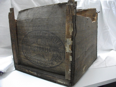
Box, butter
This butter box belonged to Jack Gore of Warrnambool who used it in his garage to store car parts. It is connected to Warrnambool Cheese and Butter Factory Company Limited through the box manufacturer, Peter John McGennan, who was one of the instigators of the factory. Cobden and Warrnambool factories were the first two co-operative factories to produce butter in Victoria, both commencing in 1888. Warrnambool Cheese and Butter Factory Company Ltd is the only remaining independent butter factory still using its original name. It is an example of the manner in which butter was packed for export from the late 19th century until well into the 20th century. Its innovative design is light but strong, using plywood for the box body and struts 'stitched' to the body with wire. The ply was originally pine imported from New Zealand which did not taint the butter. Following the exclusion of the timber from NZ, plantations of local pine were planted and used. McGennan's box factory supplied butter boxes to the majority of butter factories in Victoria, producing up to half a million boxes per year by 1917.This Cobden butter box is historically significant relating to the butter industry and a rare item. Not many of these exist. Wooden butter box with broken ends and a hole in the bottom.Constructed using thin ply ends, sides and base with square wooden struts tied with wire to strengthen the box. The trade mark on the end of the box is an oval with text around a map of Australia with the word AUSTRALIA printing across the map.COBDEN/PURE CREAMERY BUTTER/56lb Net/VICTORIA/REGD No.528butter, dairying, dairy manufacturing industry, butter boxes, cobden -
 Australian National Surfing Museum
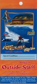
Surf Contest Pass, 2000 Bells Beach Competition Pass, 01/03/2000
This event access pass was issued to staff, vendors and community volunteers at the 2000 Rip Curl Pro at Bells Beach.The access pass is typical of the pass issued each year to the staff and workers at the longest running surfing contest in the world. The pass features unique Indigenous artwork by Torquay artist/surfer Glenn Romanis2000 Rip Curl Pro Access Pass. Full colour laminated access pass (Outside Staff) for the 2000 Rip Curl Pro and Sunsmart Classic. The pass features cover art by Indigenous artist Glenn Romanis and event management logos. The pass also features a site map on the back and access information.Event management logos on the front. Indigenous Bell artwork by Torquay artist/surfer Glenn Romanis.bells beach, rip curl, glenn romanis, surfing victoria, 2000 rip curl pro -
 Flagstaff Hill Maritime Museum and Village
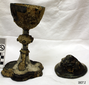
Ceremonial object - Ciborium and Lid, Before 1855
Ciborium is the ancient Greek word for the cup-shaped seed vessel of the Egyptian water lily "nelumbium speciosum" and came to describe a drinking cup made from that seed casing. These vessels were particularly common in ancient Egypt and the Greek East. The word "'ciborium'" was also used in classical Latin to describe such cups. In medieval Latin, and in English, "Ciborium" more commonly refers to a covered container used in Roman Catholic, Anglican, Lutheran and related churches to store the consecrated hosts of the sacrament of Holy Communion. It resembles the shape of a chalice but its bowl is more round than conical and takes its name from its cover, surmounted by a cross or other sacred design. This ciborium is part of a Communion Set that was recovered from the wreck of the Schomberg in 1975 after 120 years in the sea. Five years later during the cleaning of the ciborium, a diamond ring was found secreted in the underside of the ciborium's lid. This ring has since come to be called the Schomberg Diamond and is also on display as part of the Flagstaff Hill Museums Schomberg collection. In 1975, divers from Flagstaff Hill (Peter Ronald, former Director of Flagstaff Hill, Colin Goodall and Gary Hayden), found an ornate communion set at the Schomberg wreck site. The set comprised a jug, the ciborium, a chalice and a plate. The ciborium remained untouched for a number of years before restoration began and the marine growth was removed. In 1980 a piece of the lid broke off, revealing a glint of gold. As museum staff carefully examined the lid and removed marine growth, they found a diamond ring, which is currently on display in the Great Circle Gallery at Flagstaff Hill. The collection also holds ship fittings and equipment, personal effects, a lithograph, tickets as well as photographs from the Schomberg. ABOUT THE SCHOMBERG (October 6 to December 27, 1855)- When the ship Schomberg was launched in 1855, she was considered the most perfect clipper ship ever to be built. James Baine’s Black Ball Line had commissioned her for their fleet of passenger liners. The Aberdeen builders designed her to sail faster than the clippers designed the three-masted wooden clipper ship to be fast. The timber used for the diagonal planking was British oak with layers of Scottish larch. This luxury emigrant vessel was designed for superior comfort. She had ventilation ducts to provide air to the lower decks and a dining saloon, smoking room, library and bathrooms for the first-class passengers. The master for Schomberg’s maiden voyage was Captain ‘Bully’ Forbes. He drunkenly predicted at her launch that he would make the journey between Liverpool and Melbourne in 60 days. Schomberg departed Liverpool on 6 October 1855 with 430 passengers and 3000 tons of cargo including iron rails and equipment intended the build the Geelong Railway and a bridge over the Yarra from Melbourne to Hawthorn. The poor winds slowed Schomberg’s sail across the equator. She was 78 days out of Liverpool when she ran aground on a sand spit near Peterborough, Victoria, on 27 December; the sand spit and currents were not marked on Forbes’s map. The ship’s Chief Officer spotted the coastal steamer SS Queen at dawn and sent a signal. The master of the SS Queen approached the stranded vessel and all of Schomberg’s passengers safely disembarked.This ciborium is significant as an example of an item in common use in the mid-19th century that is still in use today. It is also important for it relationship with the famous Schomberg Diamond that was discovered by accident, hidden inside it. The ciborium is particularly significant in that along with other items from the wreck helped in part to have the legislation changed to protect shipwrecks, with far tighter controls being employed to oversee the salvaging of wreck sites around our coast. This salvaged item forms part of the Schomberg collection at Flagstaff Hill maritime museum. The collection as a whole is of historical and archaeological significance at a State level. Flagstaff Hill’s collection of artefacts from the Schomberg is also significant for its association with the Victorian Heritage Registered Schomberg shipwreck (VHR S 612). The collection is of additional significance because of the relationship between the objects salvaged, as together they help us to interpret the story of the Schomberg. The collection as a whole is historically significant for representing aspects of Victoria's maritime history and its potential to interpret social and historical themes from society at the time of the wreck.Silver engraved Ciborium or chalice with lid, part of the five-piece Communion Set. The chalice is a round cup with a long stem and a floral-shaped base with embossed decoration. It has a matching round lid that comes to a rounded apex on top. Engravings on chalice feature flowers and a Fleur-de-lis pattern.flagstaff hill, flagstaff hill maritime museum and village, warrnambool, maritime museum, maritime village, great ocean road, shipwreck coast, schomberg, 1855, clipper ship, james baines & co, black ball line, luxury ship, emigrant ship, captain forbes, bully forbes, ss queen, peterborough shipwreck, communion set, religious service, communion service, ceremonial service, mass, ciborium, chalice, schomberg diamond -
 Flagstaff Hill Maritime Museum and Village
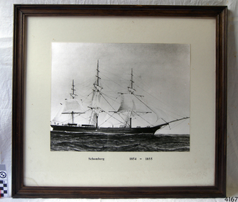
Photograph - Vessel - Sailing Ship, Schomberg 1854 - 1855, Ca. 20th century
When the ship Schomberg was launched in 1855, she was considered the most perfect clipper ship ever to be built. James Blaine’s Black Ball Line had commissioned her to be built for their fleet of passenger liners. At a cost of £43,103, the Aberdeen builders designed her to sail faster than the quick clippers designed by North American Donald McKay. She was a three masted wooden clipper ship, built with diagonal planking of British oak with layers of Scottish larch. This luxury vessel was designed to transport emigrants to Melbourne in superior comfort. She had ventilation ducts to provide air to the lower decks and a dining saloon, smoking room, library and bathrooms for the first class passengers. At the launch of Schomberg’s maiden voyage, her master Captain ‘Bully’ Forbes, drunkenly predicted that he would make the journey between Liverpool and Melbourne in 60 days. Schomberg departed Liverpool on 6 October 1855 with 430 passengers and 3000 tons cargo including iron rails and equipment intended the build the Geelong Railway and a bridge over the Yarra from Melbourne to Hawthorn. The winds were poor as Schomberg sailed across the equator, slowing her journey considerably. She was 78 days out of Liverpool when she ran aground on a sand-spit near Peterborough, Victoria, on 27 December; the sand spit and the currents were not marked on Forbes’s map. Overnight, the crew launched a lifeboat to find a safe place to land the ship’s passengers. The scouting party returned to Schomberg and advised Forbes that it was best to wait until morning because the rough seas could easily overturn the small lifeboats. The ship’s Chief Officer spotted SS Queen at dawn and signalled the steamer. The master of the SS Queen approached the stranded vessel and all of Schomberg’s passengers were able to disembark safely. The Black Ball Line’s Melbourne agent sent a steamer to retrieve the passengers’ baggage from the Schomberg. Other steamers helped unload her cargo until the weather changed and prevented the salvage teams from accessing the ship. Local merchants Manifold & Bostock bought the wreck and cargo, but did not attempt to salvage the cargo still on board the ship. They eventually sold it on to a Melbourne businessman and two seafarers. After two of the men drowned when they tried to reach Schomberg, salvage efforts were abandoned.32 In 1975, divers from Flagstaff Hill, including Peter Ronald, found an ornate communion set at the wreck. The set comprised a jug, two chalices, a plate and a lid. The lid did not fit any of the other objects and in 1978 a piece of the lid broke off, revealing a glint of gold. As museum staff carefully examined the lid and removed marine growth, they found a diamond ring, which is currently on display in the Great Circle Gallery.33 Flagstaff Hill also holds ship fittings and equipment, personal effects, a lithograph, tickets and photograph from the Schomberg. Most of the artefacts were salvaged from the wreck by Peter Ronald, former director of Flagstaff Hill. The Schomberg, which is on the Victorian Heritage Register (VHR S612), has great historical significance as a rare example of a large, fast clipper ship on the England to Australia run, carrying emigrants at the time of the Victorian gold rush. She represents the technical advances made to break sailing records between Europe and Australia. Flagstaff Hill’s collection of artefacts from the Schomberg is significant for its association with the shipwreck, The collection is primarily significant because of the relationship between the objects, as together they have a high potential to interpret the story of the Schomberg. It is archaeologically significant as the remains of an international passenger Ship. It is historically significant for representing aspects of Victoria’s shipping history and for its association with the shipwreck and the ship, which was designed to be fastest and most luxurious of its day Photograph of the sailing ship Schomberg, mounted in a wood frame behind glass with a white matt Figures can be seen on deck of the ship."Schomberg 1854-1855"warrnambool, flagstaff-hill, flagstaff-hill-maritime-museum, maritime-museum, shipwreck-coast, flagstaff-hill-maritime-village, schomberg, shipwrecked-artefact, clipper ship, black ball line, 1855 shipwreck, aberdeen clipper ship, captain forbes, peterborough shipwreck, ss queen, photograph -
 Flagstaff Hill Maritime Museum and Village
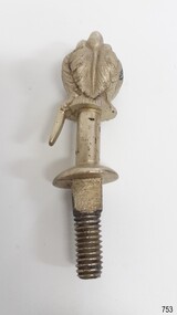
Decorative object - Buggy Fitting, Circa 1855
This ornate fitting for a horse-drawn vehicle was amongst the items recovered from the Schomberg over one hundred years after it was wrecked. ABOUT THE SCHOMBERG (October 6 to December 27, 1855)- When the ship Schomberg was launched in 1855, she was considered the most perfect clipper ship ever to be built. James Baine’s Black Ball Line had commissioned her for their fleet of passenger liners. The Aberdeen builders designed her to sail faster than the clippers designed the three-masted wooden clipper ship to be fast. The timber used for the diagonal planking was British oak with layers of Scottish larch. This luxury emigrant vessel was designed for superior comfort. She had ventilation ducts to provide air to the lower decks and a dining saloon, smoking room, library and bathrooms for the first-class passengers. The master for Schomberg’s maiden voyage was Captain ‘Bully’ Forbes. He drunkenly predicted at her launch that he would make the journey between Liverpool and Melbourne in 60 days. Schomberg departed Liverpool on 6 October 1855 with 430 passengers and 3000 tons of cargo including iron rails and equipment intended the build the Geelong Railway and a bridge over the Yarra from Melbourne to Hawthorn. The poor winds slowed Schomberg’s sail across the equator. She was 78 days out of Liverpool when she ran aground on a sand spit near Peterborough, Victoria, on 27 December; the sand spit and currents were not marked on Forbes’s map. The ship’s Chief Officer spotted the coastal steamer SS Queen at dawn and sent a signal. The master of the SS Queen approached the stranded vessel and all of Schomberg’s passengers safely disembarked. In 1975, 120 years after the Schomberg was wrecked, divers from Flagstaff Hill found an ornate communion set at the wreck site along with many other artefacts. In 1978 a diamond ring was discovered under the concretion in the lid of the communion set, which is currently on display. Former Director of Flagstaff Hill, Peter Ronald, had salvaged most of the artefacts from the wreck. The Schomberg has historical significance as one of the first luxurious ships built to bring emigrants to Australia to cash in on the gold rush era. And is included on the Victorian Heritage Register (VHR S612). The collection of Schomberg artefacts held at Flagstaff Hill Museum is primarily significant because of the relationship between these recovered items having a high potential to interpret the story of the Schomberg and its foundering during a storm. The shipwreck is of additional historically significance for representing aspects of Victoria’s shipping history and for its association with the first passenger ship, which was designed not only to be the fastest and most luxurious of its day but foundered on its maiden voyage to Australia.Ornate buggy or coach fitting with feather plumes on top, and a screw thread on the bottom. Silver plated,.warrnambool, flagstaff-hill, flagstaff-hill-maritime-museum, shipwreck-coast, flagstaff-hill-maritime-village, schomberg, shipwrecked-artefact, clipper ship, black ball line, 1855 shipwreck, aberdeen clipper ship, captain forbes, peterborough shipwreck, ss queen, artifact, ornate fitting, buggy fitting