Showing 2900 items matching "melbourne water."
-
 Eltham District Historical Society Inc
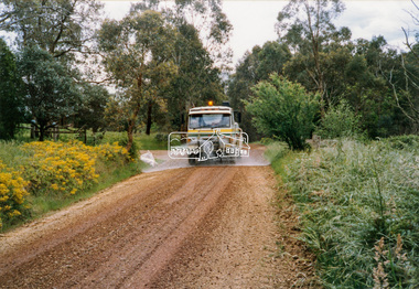
Photograph - Colour Print, Eltham Shire Council, Council oerations road grading and gravel water truck, c.1990
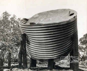
... Eltham District Historical Society Inc 728 Main Rd Eltham melbourne The cost of providing equivalent levels of services to the more rural areas of the Shire with respect to those in the more urban areas of Eltham, Montmorency and Briar Hill was relatively expensive. Road maintenance of rural unsealed gravel roads is one of those areas of higher costs particulary as a result of water ...The cost of providing equivalent levels of services to the more rural areas of the Shire with respect to those in the more urban areas of Eltham, Montmorency and Briar Hill was relatively expensive. Road maintenance of rural unsealed gravel roads is one of those areas of higher costs particulary as a result of water erosion. The same applies for Nillumbik Shire Council today. Here we see Council operations grading a road and laying new gravel, followed by a gravel water truck to help bed the surface down. Unfortunately there is no information with these prints as to where this particular location is.graders, infrastructure, road maintenance, roads, shire of eltham, rural road, unidentified -
 Eltham District Historical Society Inc
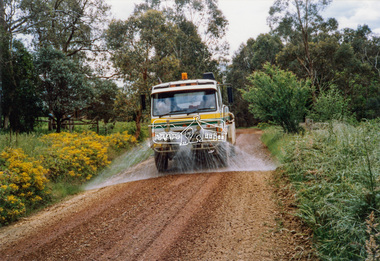
Photograph - Colour Print, Eltham Shire Council, Council oerations road grading and gravel water truck, c.1990
... Eltham District Historical Society Inc 728 Main Rd Eltham melbourne The cost of providing equivalent levels of services to the more rural areas of the Shire with respect to those in the more urban areas of Eltham, Montmorency and Briar Hill was relatively expensive. Road maintenance of rural unsealed gravel roads is one of those areas of higher costs particulary as a result of water ...The cost of providing equivalent levels of services to the more rural areas of the Shire with respect to those in the more urban areas of Eltham, Montmorency and Briar Hill was relatively expensive. Road maintenance of rural unsealed gravel roads is one of those areas of higher costs particulary as a result of water erosion. The same applies for Nillumbik Shire Council today. Here we see Council operations grading a road and laying new gravel, followed by a gravel water truck to help bed the surface down. Unfortunately there is no information with these prints as to where this particular location is.graders, infrastructure, road maintenance, roads, shire of eltham, rural road, unidentified -
 Eltham District Historical Society Inc
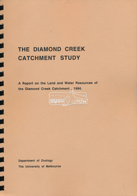
Book, Department of Zoology, The University of Melbourne, The Diamond Creek Catchment Study: A report on the Land and Water Resources of the Diamond Creek Catchment, 1994
... Eltham District Historical Society Inc 728 Main Rd Eltham melbourne Shire of Nillumbik Spiral bound, soft cover, A4, 368 pages, 368 pages The Diamond Creek Catchment Study: A report on the Land and Water Resources of the Diamond Creek Catchment Book Book Department of Zoology, The University of Melbourne ...Shire of Nillumbik -
 Eltham District Historical Society Inc
Document - Folder, Survey Maps and Technical Drawings
... Gardner, ink and water colour, ¼” to 1’ 0” (rolled and colour copy) 23. Technical Drawing: Melbourne Technical School, Brick Culvert, Scale 3/8” = 1’ 0”; Drawn by A. ...Gardner, ink and water colour, ¼” to 1’ 0” (rolled and colour copy) 23. Technical Drawing: Melbourne Technical School, Brick Culvert, Scale 3/8” = 1’ 0”; Drawn by A. ...alan gardiner collection, maps -
 Eltham District Historical Society Inc
Photograph, Headmaster's Residence, Eltham State School No. 209, Dalton Street, Eltham, c.1920
... Eltham District Historical Society Inc 728 Main Rd Eltham melbourne Pre town water of 1926. Water tank is cube shaped used as containers of powders etc from overseas. dalton street eltham eltham state school no. 209 headmaster's resience A4 paper inket print Headmaster's Residence, Eltham State School No. 209, Dalton Street, Eltham Photograph Photograph ...Pre town water of 1926. Water tank is cube shaped used as containers of powders etc from overseas.dalton street, eltham, eltham state school no. 209, headmaster's resience -
 Eltham District Historical Society Inc
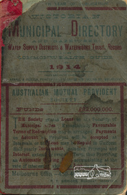
Book, Arnall & Jackson Pty ltd, Victorian Municipal Directory 1914 published by Arnall & Jackson Pty. Ltd, 1914
... Eltham District Historical Society Inc 728 Main Rd Eltham melbourne Victorian municipal directory and Commonwealth and state guide and water supply record for 1914 government commonwealth and victoria water supply victoria xxiv, 743 pages ; 19 cm. ...Victorian municipal directory and Commonwealth and state guide and water supply record for 1914xxiv, 743 pages ; 19 cm.government commonwealth and victoria, water supply victoria -
 Eltham District Historical Society Inc
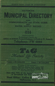
Book, Victorian Municipal Directory 1955 published by Arnall & Jackson Pty. Ltd, 1955
... Eltham District Historical Society Inc 728 Main Rd Eltham melbourne Victorian municipal directory and Commonwealth and state guide and water supply record for 1955 government commonwealth and victoria water supply victoria xxxiv 1071 p. ; 19 cm. ...Victorian municipal directory and Commonwealth and state guide and water supply record for 1955xxxiv 1071 p. ; 19 cm.government commonwealth and victoria, water supply victoria -
 Eltham District Historical Society Inc
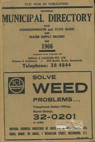
Book, Arnall & Jackson Pty ltd, Victorian Municipal Directory 1966 published by Arnall & Jackson Pty. Ltd, 1966
... Eltham District Historical Society Inc 728 Main Rd Eltham melbourne Victorian municipal directory and Commonwealth and state guide and water supply record for 1955 government commonwealth and victoria water supply victoria xxiv, 1150 pages ; 19 cm. ...Victorian municipal directory and Commonwealth and state guide and water supply record for 1955xxiv, 1150 pages ; 19 cm.government commonwealth and victoria, water supply victoria -
 Eltham District Historical Society Inc
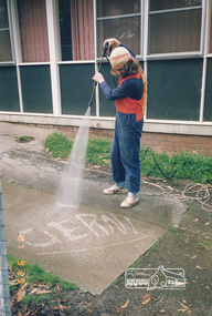
Photograph, Gerni High Pressure Water Cleaner - Engineering Design
... Eltham District Historical Society Inc 728 Main Rd Eltham melbourne One of a set of display images thought to be produced by the Shire of Eltham c.1979-1987 Illustrative of services provided by former Shire of Eltham cleaning maintenance Title printed on label adhered to board below photograph (replaced June 2017) Colour photograph 20 x 29 cm mounted on green-painted chipboard 28 x 35.5 cm (string on back for hanging) Gerni High Pressure Water Cleaner - Engineering Design Photograph ...One of a set of display images thought to be produced by the Shire of Eltham c.1979-1987Illustrative of services provided by former Shire of ElthamColour photograph 20 x 29 cm mounted on green-painted chipboard 28 x 35.5 cm (string on back for hanging)Title printed on label adhered to board below photograph (replaced June 2017)cleaning, maintenance -
 Eltham District Historical Society Inc
Photograph, George W. Bell, Christmas Hills bushfire, Jan. 1962, Jan 1962
... melbourne Building of Pensioners Cottages at St Andrews; for those burnt out in the 1962 bushfires. A voluntary scheme of Mavis Gill through the Kangaroo Ground Relief Committee victorian bushfires - 1962 bushfires fire damage - buildings george w bell houses st andrews mavis gill pensioners cottages christmas hills water tank Christmas Hills bushfire Photo Geo. ...Building of Pensioners Cottages at St Andrews; for those burnt out in the 1962 bushfires. A voluntary scheme of Mavis Gill through the Kangaroo Ground Relief CommitteeBlack and white photo mounted on cardChristmas Hills bushfire Photo Geo. W. Bell, Jan. 1962victorian bushfires - 1962, bushfires, fire damage - buildings, george w bell, houses, st andrews, mavis gill, pensioners cottages, christmas hills, water tank -
 Eltham District Historical Society Inc
Newsletter, Newsletter, No. 77 March 1991
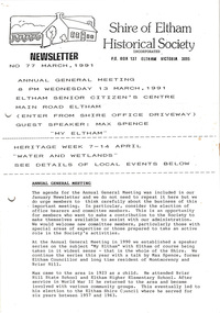
... Eltham District Historical Society Inc 728 Main Rd Eltham melbourne Contents: • Next meeting, guest speaker; Max Spence: My Eltham • Annual General Meeting • Heritage Week – Water and Wetlands • 1991 Photo Project • Eltham R.S.L. • Society Program The Shire of Eltham Historical Society was formed in October 1967. ...Contents: • Next meeting, guest speaker; Max Spence: My Eltham • Annual General Meeting • Heritage Week – Water and Wetlands • 1991 Photo Project • Eltham R.S.L. • Society Program The Shire of Eltham Historical Society was formed in October 1967. The first newsletter of the Society was issued May 1978 and has been published continuously ever since on a bi-monthly basis. With the cessation of the Shire of Eltham in late 1994, the Society's name was revised to Eltham District Historical Society and this name first appeared with issue No. 103, July 1995. The collection of the Society's newsletters provides a valuable resource on the history of the Society's activities, office bearers and committee members, guest speakers and subjects of historical interest pertinent to the former Shire of Eltham and the Eltham District.A4 photocopied newsletter distributed to membersnewsletter, eltham district historical society, shire of eltham historical society -
 Eltham District Historical Society Inc
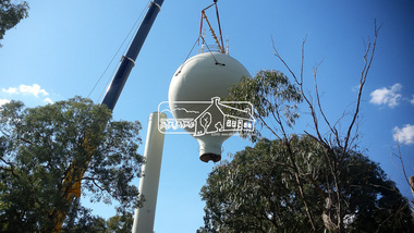
Photograph, Demolition of water tower at 51 Cassells Road, Research, 6 April 2017, 6/4/2017
... Eltham District Historical Society Inc 728 Main Rd Eltham melbourne "The water storage tank (the ‘golf ball’ tower) was located in Cassells Road, and for many years it played an important role in supplying the Research and Eltham communities with drinking water. ..."The water storage tank (the ‘golf ball’ tower) was located in Cassells Road, and for many years it played an important role in supplying the Research and Eltham communities with drinking water. However, due to prior upgrades of water supply infrastructure in the area, these communities are receiving their water supply in a more reliable way. The storage tank was no longer operating and as it no longer served a purpose, the time had come for it to be removed. Decommissioning works occurred between November 2016 and January 2017, and the tower was removed in March 2017." Source: Yarra Valley Water Eltham Water Project onlineDigital files only (17 jpg and one two second MP4 files)cassells road, demolition, research (vic.), water tower -
 Eltham District Historical Society Inc
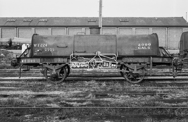
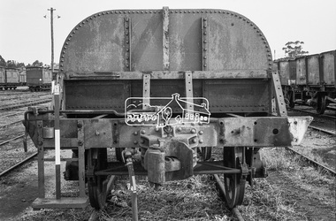
Photograph, Water Tank Wagon WT-224, Bendigo Railway Station, c.Oct. 1962
... Eltham District Historical Society Inc 728 Main Rd Eltham melbourne Bendigo Bendigo Rail Yard Bendigo Railway Station George Coop Collection Victorian Railways Wagon Water Tank Wagon WT-224 Digital TIFF file Scan of 35mm Ilford FP3 black and white negative transparency Water Tank Wagon WT-224, Bendigo Railway Station Photograph Photograph George Coop George Coop ...Digital TIFF file Scan of 35mm Ilford FP3 black and white negative transparencybendigo, bendigo rail yard, bendigo railway station, george coop collection, victorian railways, wagon, water tank wagon, wt-224 -
 Eltham District Historical Society Inc
Photograph, Steam locomotive R-708 outside the locomotive workshop, Bendigo Railway Station, c. November 1962
... Eltham District Historical Society Inc 728 Main Rd Eltham melbourne "View outwards from the inside from the northern entrance to the loco shed. R708 is at the water crane in the distance" - Newsrail October 2020 bendigo, bendigo railway station, george coop collection, r-708, r-class steam locomotive locomotive shed Digital TIFF file Scan of 35mm Ilford FP3 black and white negative transparency Steam locomotive R-708 outside the locomotive workshop, Bendigo Railway Station Photograph Photograph George Coop George Coop ..."View outwards from the inside from the northern entrance to the loco shed. R708 is at the water crane in the distance" - Newsrail October 2020Digital TIFF file Scan of 35mm Ilford FP3 black and white negative transparencybendigo, bendigo railway station, george coop collection, r-708, r-class steam locomotive, locomotive shed -
 Eltham District Historical Society Inc
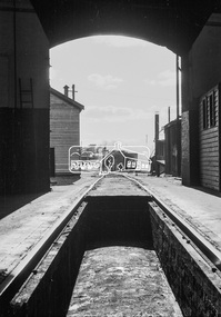
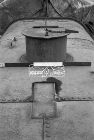
Photograph, Top of water tank wagon at Echuca Railway yards, c.November 1962, 1962
... Eltham District Historical Society Inc 728 Main Rd Eltham melbourne echuca railway station, george coop collection, water tank wagon Digital TIFF file Scan of 35mm Ilford FP3 black and white negative transparency Top of water tank wagon at Echuca Railway yards, c.November 1962 Photograph Photograph George Coop George Coop ...Digital TIFF file Scan of 35mm Ilford FP3 black and white negative transparencyechuca railway station, george coop collection, water tank wagon -
 Eltham District Historical Society Inc
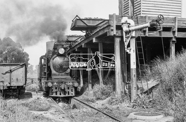
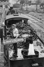
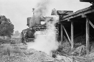
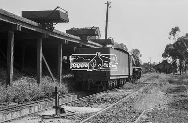
Photograph, Steam locomotive K-158 at the coal hopper, Echuca Railway Station, November 1963, 1963
... melbourne THE ECHUCA COALING STAGE. Locomotives would stop alongside to receive coal dropped into their tenders from small overhead rail mounted tipping trays. Water ...THE ECHUCA COALING STAGE. Locomotives would stop alongside to receive coal dropped into their tenders from small overhead rail mounted tipping trays. Water could be obtained from either the elevated tank at one end or the connected standpipe at the opposite end. Locomotive firebox contents could be dumped into pits between the rails from locomotives once they were carefully positioned above them. Such locomotives then could move onto the Engine Shed area for overnight parking. Firebox fires would be re-lit when the locomotive was next needed in a day or so. Image dated as November 1963 based on same image in Port of Echuca collection (possibly frame 32 of film) (print 19.5 x 24.5cm) On reverse in pencil: " K Class at Echuca" Echuca K Class. 1940-1968". In blue pen:" Photo by: George L. Coop Nov 1963" https://victoriancollections.net.au/items/59de9cc421ea6b12dc3f7597Digital TIFF file Scan of 35mm Ilford FP3 black and white negative transparencycoal hopper, echuca railway station, george coop collection, k-158, k-class steam locomotive (vr newport workshops) -
 Eltham District Historical Society Inc
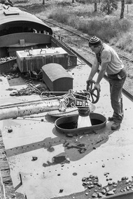
Photograph, Steam locomotive K-158 filling up with water at the coal hopper, Echuca Railway Station, November 1963, 1963
... melbourne THE ECHUCA COALING STAGE. Locomotives would stop alongside to receive coal dropped into their tenders from small overhead rail mounted tipping trays. Water ...THE ECHUCA COALING STAGE. Locomotives would stop alongside to receive coal dropped into their tenders from small overhead rail mounted tipping trays. Water could be obtained from either the elevated tank at one end or the connected standpipe at the opposite end. Locomotive firebox contents could be dumped into pits between the rails from locomotives once they were carefully positioned above them. Such locomotives then could move onto the Engine Shed area for overnight parking. Firebox fires would be re-lit when the locomotive was next needed in a day or so.Digital TIFF file Scan of 35mm Ilford FP3 black and white negative transparencycoal hopper, echuca railway station, george coop collection, k-158, k-class steam locomotive (vr newport workshops) -
 Eltham District Historical Society Inc
Photograph, Steam locomotive J-500 at the coal hopper, Echuca Railway Station, November 1963, 1963
... melbourne THE ECHUCA COALING STAGE. Locomotives would stop alongside to receive coal dropped into their tenders from small overhead rail mounted tipping trays. Water ...THE ECHUCA COALING STAGE. Locomotives would stop alongside to receive coal dropped into their tenders from small overhead rail mounted tipping trays. Water could be obtained from either the elevated tank at one end or the connected standpipe at the opposite end. Locomotive firebox contents could be dumped into pits between the rails from locomotives once they were carefully positioned above them. Such locomotives then could move onto the Engine Shed area for overnight parking. Firebox fires would be re-lit when the locomotive was next needed in a day or so.Digital TIFF file Scan of 35mm Ilford FP3 black and white negative transparencyechuca railway station, george coop collection, j-500, j-class steam locomotive (vulcan foundry) -
 Eltham District Historical Society Inc
Photograph, Steam locomotive R-727 at the coal hopper, Echuca Railway Station, November 1963, 1963
... melbourne THE ECHUCA COALING STAGE. Locomotives would stop alongside to receive coal dropped into their tenders from small overhead rail mounted tipping trays. Water ...THE ECHUCA COALING STAGE. Locomotives would stop alongside to receive coal dropped into their tenders from small overhead rail mounted tipping trays. Water could be obtained from either the elevated tank at one end or the connected standpipe at the opposite end. Locomotive firebox contents could be dumped into pits between the rails from locomotives once they were carefully positioned above them. Such locomotives then could move onto the Engine Shed area for overnight parking. Firebox fires would be re-lit when the locomotive was next needed in a day or so.Digital TIFF file Scan of 35mm Ilford FP3 black and white negative transparencycoal hopper, echuca, echuca railway station, george coop collection, r-727, r-class steam locomotive -
 Eltham District Historical Society Inc
Photograph, Steam locomotive R-727 being filled with water at the coal hopper, Echuca Railway Station, November 1963, 1963
... melbourne THE ECHUCA COALING STAGE. Locomotives would stop alongside to receive coal dropped into their tenders from small overhead rail mounted tipping trays. Water ...THE ECHUCA COALING STAGE. Locomotives would stop alongside to receive coal dropped into their tenders from small overhead rail mounted tipping trays. Water could be obtained from either the elevated tank at one end or the connected standpipe at the opposite end. Locomotive firebox contents could be dumped into pits between the rails from locomotives once they were carefully positioned above them. Such locomotives then could move onto the Engine Shed area for overnight parking. Firebox fires would be re-lit when the locomotive was next needed in a day or so.Digital TIFF file Scan of 35mm Ilford FP3 black and white negative transparencycoal hopper, echuca, echuca railway station, george coop collection, r-727, r-class steam locomotive -
 Eltham District Historical Society Inc
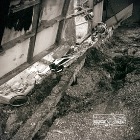
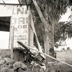
Photograph, Subsidence to carport as a result of water damage, possibly near Mountainview Road, Briar Hill, c.1965, 1965c
... Eltham District Historical Society Inc 728 Main Rd Eltham melbourne floods, houses, Victa lawn mower Black and white negative film, 120 6x6 format, 3 continuous frames, sectioned Subsidence to carport as a result of water damage, possibly near Mountainview Road, Briar Hill, c.1965 Photograph ...Black and white negative film, 120 6x6 format, 3 continuous frames, sectionedfloods, houses, victa lawn mower -
 Eltham District Historical Society Inc
Photograph, Subsidence to carport as a result of water damage, possibly near Mountainview Road, Briar Hill, c.1965, 1965c
... Eltham District Historical Society Inc 728 Main Rd Eltham melbourne floods, houses Black and white negative film, 120 6x6 format, 3 continuous frames, sectioned Subsidence to carport as a result of water damage, possibly near Mountainview Road, Briar Hill, c.1965 Photograph ...Black and white negative film, 120 6x6 format, 3 continuous frames, sectionedfloods, houses -
 Eltham District Historical Society Inc
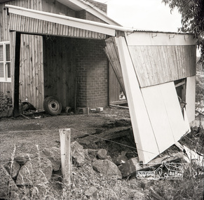
Photograph, Subsidence to carport as a result of water damage, possibly near Mountainview Road, Briar Hill, c.1965, 1965c
... melbourne Possibly Al Saunders at Hurstbridge? floods, houses Black and white negative film, 120 6x6 format, 3 continuous frames, sectioned Subsidence to carport as a result of water damage, possibly near Mountainview Road, Briar Hill, c.1965 Photograph ...Possibly Al Saunders at Hurstbridge?Black and white negative film, 120 6x6 format, 3 continuous frames, sectionedfloods, houses -
 Eltham District Historical Society Inc
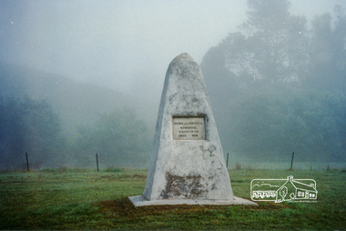
Photograph, Hume and Hovell Monument, Broadford, Autumn Excursion, Hume and Hovell's 1824 expedition, 26 May 1996, 26/05/1996
... Melbourne and surroundings and the excitement of arriving and departing aircraft. Our next river crossing was at Werribee, "in a vast treeless plain", then we drove on by-ways no coach had previously travelled, to find "an immense sheet of water" salty Corio Bay, off-course to the west. ...Melbourne and surroundings and the excitement of arriving and departing aircraft. Our next river crossing was at Werribee, "in a vast treeless plain", then we drove on by-ways no coach had previously travelled, to find "an immense sheet of water" salty Corio Bay, off-course to the west. ...[article by Bettina Woodburn in EDHS Newsletter No. 109, July 1996:] ON THE TRAIL OF HUME AND HOVELL - REPORT ON THE AUTUMN EXCURSION - On a green and fresh morning (Sunday 26th May 1996) the Cobb and Co coach (driven by the most obliging Peter Tampion) set off in a north easterly direction from Eltham to connect with Hume and Hovell's route on their 1824 explorations of central Victoria. The Society would follow a series of monuments erected for the 1924 centenary of the expedition from King Parrot Creek (Tuesday 7th December 1824), through Strath Creek, over Sunday Creek (Sunday 12th December 1824) at Broadford, Tullamarine, St Albans, Deer Park, through Werribee, skirting east of the You Yangs to Lara and Avalon Beach. Because their distance-measuring wheel had broken and a one degree mistake was made in calculations, the two leaders of the original group of six convict-companions arrived at Corio Bay, instead of the expected Western Port, discovered earlier by Flinders. From below Mt. Disappointment (Hume and Hovell's difficulties in "scrambling over brush and rock", "leeches in forest, as well as no water", "cutting grass 4-5 ft. high", dreadful scrub", "devil flies") we took an easier route, saw the Strath Creek memorial in ground fog and a wonderful "field of dreams", the Hume-Hovell privately owned cricket ground with its white picket boundary fence. Now, after a steep climb, in sunshine under gums we stretched and viewed magnificent rolling hills and fog-filled valleys - not "smoke from Aborigines' bush fires". After morning tea at Broadford we followed the Sunday Creek valley beside the Hume Freeway, passed the Wallan Wallan Rest Area (more appropriately Hume and Hovell Rest Area) to tum right at Beveridge. In Gellibrand Hill Park, near the headwaters of the Moonee Ponds Creek, we experienced the landscape the first European settlers saw - huge river red gums and rolling pastures. The gardens and sheltered courtyard of the 1840s, timber, brought from .....[?] prefabricated Woodlands Homestead, provided a pleasant lunch stop. We enjoyed a private tour, panoramic views over Melbourne and surroundings and the excitement of arriving and departing aircraft. Our next river crossing was at Werribee, "in a vast treeless plain", then we drove on by-ways no coach had previously travelled, to find "an immense sheet of water" salty Corio Bay, off-course to the west. In late afternoon of a super, calm, late autumn day we headed homewards. Back at Eltham we were rather surprised to find that we had travelled a total of 347 km. Thanks again to Russell Yeoman for his research and organization. What a wonderful day! Colour photographactivities, broadford, hume and hovell, monument -
 Eltham District Historical Society Inc
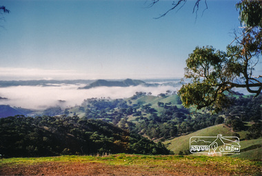
Photograph, Strath Creek, Autumn Excursion, Hume and Hovell's 1824 expedition, 26 May 1996, 26/05/1996
... Melbourne and surroundings and the excitement of arriving and departing aircraft. Our next river crossing was at Werribee, "in a vast treeless plain", then we drove on by-ways no coach had previously travelled, to find "an immense sheet of water" salty Corio Bay, off-course to the west. ...Melbourne and surroundings and the excitement of arriving and departing aircraft. Our next river crossing was at Werribee, "in a vast treeless plain", then we drove on by-ways no coach had previously travelled, to find "an immense sheet of water" salty Corio Bay, off-course to the west. ...[article by Bettina Woodburn in EDHS Newsletter No. 109, July 1996:] ON THE TRAIL OF HUME AND HOVELL - REPORT ON THE AUTUMN EXCURSION - On a green and fresh morning (Sunday 26th May 1996) the Cobb and Co coach (driven by the most obliging Peter Tampion) set off in a north easterly direction from Eltham to connect with Hume and Hovell's route on their 1824 explorations of central Victoria. The Society would follow a series of monuments erected for the 1924 centenary of the expedition from King Parrot Creek (Tuesday 7th December 1824), through Strath Creek, over Sunday Creek (Sunday 12th December 1824) at Broadford, Tullamarine, St Albans, Deer Park, through Werribee, skirting east of the You Yangs to Lara and Avalon Beach. Because their distance-measuring wheel had broken and a one degree mistake was made in calculations, the two leaders of the original group of six convict-companions arrived at Corio Bay, instead of the expected Western Port, discovered earlier by Flinders. From below Mt. Disappointment (Hume and Hovell's difficulties in "scrambling over brush and rock", "leeches in forest, as well as no water", "cutting grass 4-5 ft. high", dreadful scrub", "devil flies") we took an easier route, saw the Strath Creek memorial in ground fog and a wonderful "field of dreams", the Hume-Hovell privately owned cricket ground with its white picket boundary fence. Now, after a steep climb, in sunshine under gums we stretched and viewed magnificent rolling hills and fog-filled valleys - not "smoke from Aborigines' bush fires". After morning tea at Broadford we followed the Sunday Creek valley beside the Hume Freeway, passed the Wallan Wallan Rest Area (more appropriately Hume and Hovell Rest Area) to tum right at Beveridge. In Gellibrand Hill Park, near the headwaters of the Moonee Ponds Creek, we experienced the landscape the first European settlers saw - huge river red gums and rolling pastures. The gardens and sheltered courtyard of the 1840s, timber, brought from .....[?] prefabricated Woodlands Homestead, provided a pleasant lunch stop. We enjoyed a private tour, panoramic views over Melbourne and surroundings and the excitement of arriving and departing aircraft. Our next river crossing was at Werribee, "in a vast treeless plain", then we drove on by-ways no coach had previously travelled, to find "an immense sheet of water" salty Corio Bay, off-course to the west. In late afternoon of a super, calm, late autumn day we headed homewards. Back at Eltham we were rather surprised to find that we had travelled a total of 347 km. Thanks again to Russell Yeoman for his research and organization. What a wonderful day! Colour photographactivities, monument, hume and hovell, murchison valley, strath creek -
 Eltham District Historical Society Inc
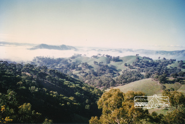
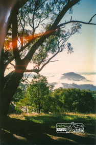
Photograph, Murchison Gap viewed from Strath Creek, Autumn Excursion, Hume and Hovell's 1824 expedition, 26 May 1996, 26/05/1996
... Melbourne and surroundings and the excitement of arriving and departing aircraft. Our next river crossing was at Werribee, "in a vast treeless plain", then we drove on by-ways no coach had previously travelled, to find "an immense sheet of water" salty Corio Bay, off-course to the west. ...Melbourne and surroundings and the excitement of arriving and departing aircraft. Our next river crossing was at Werribee, "in a vast treeless plain", then we drove on by-ways no coach had previously travelled, to find "an immense sheet of water" salty Corio Bay, off-course to the west. ...[article by Bettina Woodburn in EDHS Newsletter No. 109, July 1996:] ON THE TRAIL OF HUME AND HOVELL - REPORT ON THE AUTUMN EXCURSION - On a green and fresh morning (Sunday 26th May 1996) the Cobb and Co coach (driven by the most obliging Peter Tampion) set off in a north easterly direction from Eltham to connect with Hume and Hovell's route on their 1824 explorations of central Victoria. The Society would follow a series of monuments erected for the 1924 centenary of the expedition from King Parrot Creek (Tuesday 7th December 1824), through Strath Creek, over Sunday Creek (Sunday 12th December 1824) at Broadford, Tullamarine, St Albans, Deer Park, through Werribee, skirting east of the You Yangs to Lara and Avalon Beach. Because their distance-measuring wheel had broken and a one degree mistake was made in calculations, the two leaders of the original group of six convict-companions arrived at Corio Bay, instead of the expected Western Port, discovered earlier by Flinders. From below Mt. Disappointment (Hume and Hovell's difficulties in "scrambling over brush and rock", "leeches in forest, as well as no water", "cutting grass 4-5 ft. high", dreadful scrub", "devil flies") we took an easier route, saw the Strath Creek memorial in ground fog and a wonderful "field of dreams", the Hume-Hovell privately owned cricket ground with its white picket boundary fence. Now, after a steep climb, in sunshine under gums we stretched and viewed magnificent rolling hills and fog-filled valleys - not "smoke from Aborigines' bush fires". After morning tea at Broadford we followed the Sunday Creek valley beside the Hume Freeway, passed the Wallan Wallan Rest Area (more appropriately Hume and Hovell Rest Area) to tum right at Beveridge. In Gellibrand Hill Park, near the headwaters of the Moonee Ponds Creek, we experienced the landscape the first European settlers saw - huge river red gums and rolling pastures. The gardens and sheltered courtyard of the 1840s, timber, brought from .....[?] prefabricated Woodlands Homestead, provided a pleasant lunch stop. We enjoyed a private tour, panoramic views over Melbourne and surroundings and the excitement of arriving and departing aircraft. Our next river crossing was at Werribee, "in a vast treeless plain", then we drove on by-ways no coach had previously travelled, to find "an immense sheet of water" salty Corio Bay, off-course to the west. In late afternoon of a super, calm, late autumn day we headed homewards. Back at Eltham we were rather surprised to find that we had travelled a total of 347 km. Thanks again to Russell Yeoman for his research and organization. What a wonderful day! Colour photographactivities, hume and hovell, murchison valley, murchison gap, strath creek -
 Eltham District Historical Society Inc
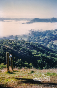
Photograph, Murchison Gap viewed from Strath Creek, Autumn Excursion, Hume and Hovell's 1824 expedition, 26 May 1996, 26/05/1996
... Melbourne and surroundings and the excitement of arriving and departing aircraft. Our next river crossing was at Werribee, "in a vast treeless plain", then we drove on by-ways no coach had previously travelled, to find "an immense sheet of water" salty Corio Bay, off-course to the west. ...Melbourne and surroundings and the excitement of arriving and departing aircraft. Our next river crossing was at Werribee, "in a vast treeless plain", then we drove on by-ways no coach had previously travelled, to find "an immense sheet of water" salty Corio Bay, off-course to the west. ...[article by Bettina Woodburn in EDHS Newsletter No. 109, July 1996:] ON THE TRAIL OF HUME AND HOVELL - REPORT ON THE AUTUMN EXCURSION - On a green and fresh morning (Sunday 26th May 1996) the Cobb and Co coach (driven by the most obliging Peter Tampion) set off in a north easterly direction from Eltham to connect with Hume and Hovell's route on their 1824 explorations of central Victoria. The Society would follow a series of monuments erected for the 1924 centenary of the expedition from King Parrot Creek (Tuesday 7th December 1824), through Strath Creek, over Sunday Creek (Sunday 12th December 1824) at Broadford, Tullamarine, St Albans, Deer Park, through Werribee, skirting east of the You Yangs to Lara and Avalon Beach. Because their distance-measuring wheel had broken and a one degree mistake was made in calculations, the two leaders of the original group of six convict-companions arrived at Corio Bay, instead of the expected Western Port, discovered earlier by Flinders. From below Mt. Disappointment (Hume and Hovell's difficulties in "scrambling over brush and rock", "leeches in forest, as well as no water", "cutting grass 4-5 ft. high", dreadful scrub", "devil flies") we took an easier route, saw the Strath Creek memorial in ground fog and a wonderful "field of dreams", the Hume-Hovell privately owned cricket ground with its white picket boundary fence. Now, after a steep climb, in sunshine under gums we stretched and viewed magnificent rolling hills and fog-filled valleys - not "smoke from Aborigines' bush fires". After morning tea at Broadford we followed the Sunday Creek valley beside the Hume Freeway, passed the Wallan Wallan Rest Area (more appropriately Hume and Hovell Rest Area) to tum right at Beveridge. In Gellibrand Hill Park, near the headwaters of the Moonee Ponds Creek, we experienced the landscape the first European settlers saw - huge river red gums and rolling pastures. The gardens and sheltered courtyard of the 1840s, timber, brought from .....[?] prefabricated Woodlands Homestead, provided a pleasant lunch stop. We enjoyed a private tour, panoramic views over Melbourne and surroundings and the excitement of arriving and departing aircraft. Our next river crossing was at Werribee, "in a vast treeless plain", then we drove on by-ways no coach had previously travelled, to find "an immense sheet of water" salty Corio Bay, off-course to the west. In late afternoon of a super, calm, late autumn day we headed homewards. Back at Eltham we were rather surprised to find that we had travelled a total of 347 km. Thanks again to Russell Yeoman for his research and organization. What a wonderful day! Colour photographactivities, hume and hovell, murchison valley, murchison gap, strath creek