Showing 660 items
matching mine plans
-
 Bendigo Historical Society Inc.
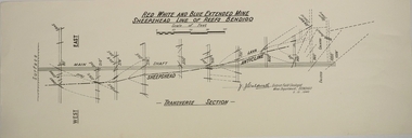
Map - RED WHITE AND BLUE EXTENDED MINE, 5/12/1940
Map: Transverse section of The Red, White and Blue Extended Mine, Sheepshead line of Reef, Bendigo. (9 Copies). By J.J. Caldwell, District Field Geologist, Mines Department Bendigo 5.12.1940map, bendigo, mining plan, red white and blue extended mine, sheepshead line of reef, mining , gold mines, j.j. caldwell -
 Bendigo Historical Society Inc.
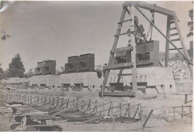
Photograph - Napoleon Reef Gold Mine Battery Site, 1936
The Napoleon (BML) gold mine (1932) was located near McDougall Road, Golden Gully, between Martin and Hattam Street. It had a depth of 921 feet. It was one of the latest and most lavish of Bendigo's mines. Plant and equipment were electrically driven. The four-compartment shaft, extra large by goldfield's standards, measured 17 feet 6 inches by 5 feet 2 inches and was cement lined below 900 feet instead of being red gum boxed as was the usual practice. The workshop was equipped to carry out all repairs for the equally lavish BML mines on the Nell Gwynne and Carshalton reefs. (The Gold Mines of Bendigo, Book 2, Arthur Victor Palmer) 'Napoleon BML Mines No Liability have issued a report for the fortnight ended September 5, where it states that the development scheme has been formulated and necessary equipment is being ordered. The Napoleon main shaft, (about 1700 feet south of the old Napoleon shaft) will be a four compartment shaft (17ft 6 inches by ft 2 inches inside the timber). aLevels will be opened at approximately 100 ft vertical intervals and cross-cuts extended approximately 125 ft each side of centre country to explore a cross-section across the anticline opposite to the shaft. At every fifth level, main drives will be extended north to connect with the old Napoleon shaft and south approximately 1800 ft. At the latter point, another cross-section of the anticline will be explored by rising and cross-cutting. The old Napoleon will be unwatered and on the 500ft and 1000 ft levels main drives will be driven to connect with main levels from the Napoleon main shaft to the south as well as being driven north 1800 ft where another cross-section of the anticline will be explored. Cross-sections further north and south may be developed as desired and also at intermediate points if necessary. Clearing and grading of the main shaft site are now in progress and the erection of the office and store building is proceeding. The design of engine room, change house and machine shops is now in hand and erection will proceed as soon as working plans and specifications are prepared.' The main shaft has been commenced at 3ft and advanced 10 ft. to 13 ft. https://trove.nla.gov.au/newspaper/article/10975478?searchTerm=napoleon%20bml (The Argus, 8th. September 1934, 'Mining' page 18) Significant to mining history of Bendigo.Black and white photograph of a stamper head being lowered into position on the battery site of the Napoleon Reef Gold Mine. A wooden gantry supports the battery head as it being lowered. Three large concrete foundations are visible in immediate background, two of which have stampers already in position, the third stamper is being lowered onto the final foundation. In immediate foreground, 'boxing' is erected for future concrete pours. napoleon gold mine, napoleon reef gold mine -
 Bendigo Historical Society Inc.
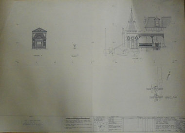
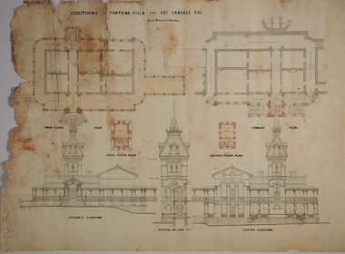
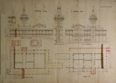
Plan - FORTUNA COLLECTION: FORTUNA VILLA
Originally built by Christopher Ballestedt (1796-1869) and his son Theodore. The Ballestedt's pioneered open cut and quartz mining on the Bendigo gold field. They were very successful. After Christopher's death, Theodore continued until 1871 when he sold Fortuna, their mines and equipment to George Lansell for 30,000 pounds.Four large plans of Fortuna villa. Scale 1:50 Australian survey office - Victoria Department of Administrative services. Fortuna Bendigo - Army Survey Regiment. Dept. of Defence - Army. Terrestrial Photogrammetric Survey. Project number: 8001/2. Reg. File: 64/531. Survey File:631. Draftsman: M.A. Osciak. Surveyed by G. Tucker. Date of Survey: 14/05/79. There are 4 large such plans in a plastic bag the measurement of the plans is approx. 115cm X 80 cm.plan, bendigo, fortuna villa -
 Bendigo Historical Society Inc.
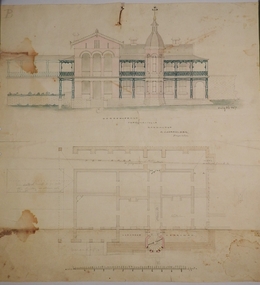
Document - HUSTLERS REEF RESERVE CONSERVATION MANAGEMENT PLAN
... Hustlers Mine site. Leigh McKinnons amendments to the plan ...Conservation management plan (112 pages) prepared by Lee Andrews & Associates, Heritage Consultants, in 2011, for the Hustlers Reef Reserve. The reserve cover the site of the former Great Extended Hustlers Mine site. Leigh McKinnons amendments to the plan are included with the document. History of the site, a physical survey and analysis, comparative analysis, cultural significance and conservation policy are addressed in the document.bendigo, mining, great extended hustlers mine site -
 Bendigo Historical Society Inc.
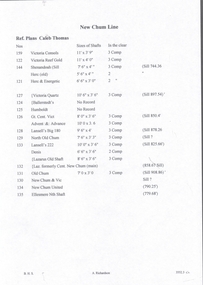
Document - NEW CHUM LINE OF REEF - REFERENCE TO CALEB THOMAS PLANS
... Five pages of reference numbers used on Caleb Thomas plans...DOCUMENT Gold mines New Chum Line Of Reef Reference ...Five pages of reference numbers used on Caleb Thomas plans. Has the mine's name, size of shaft and on other pages, the height of the sill. One mine on the Sheepshead Line, the New St Mungo is mentioned. Many mines along the reef are mentioned.document, gold, mines, new chum line of reef, reference to caleb thomas plans, catherine reef extd., new franklin, murchison, catherine reef united, catherine reef (south), acadia catherine, william's united, york & durham, belmont & saxby, ellenborough, sadowa, (old) st mungo, lady barkly, princess alice (sth st mungo), unicorn trib, pheonix, hopewell, united devonshire (princess alex), west united devonshire, east united devonshire, duchess of edinburgh, south devonshire, duchess tribute, new st mungo, new st mungo, new vict catherine, gt extd vict, herc new chum (late pearl), pearl south, north herc & energetic, herc & energetic, ironbark, vict consols, south new chum, lansell's 616, south belle vue, eureka extd, new chum rly, south old chum, new chum consolidated, ellesmere (south shaft), garibaldi, cravens, young chum, ellesmere nth shaft, new chum united, new chum vic, old chum, lazarus, cent new chum, lansell's 222, north old chum, lansell's big 180, advents advance, gt cent vict, hamboldt, ballerstedt, victoria quartz, herc & energetic, herc (old), shenandoah, victoria reef gold, victoria consols -
 Bendigo Historical Society Inc.
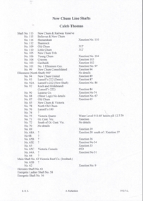
Document - NEW CHUM LINE OF REEF - REFERENCE FOR CALEB THOMAS PLANS
Two handwritten pages of reference numbers for Caleb Thomas plans. The numbers refer to mines on the New Chum Line of Reef.document, gold, new chum line of reef, reference for caleb thomas plans, new chum bellevue & railway reserve, bellevue & new chum, shenandoah, shamrock, old chum, little chum, new chum trib, young chum, cravens, garibaldi, no 1 ellesmere coy, new chum consolidated, ellesmere, new chum united, lansell's 222 (denis), lansell's 222 (new shaft), koch & hildebrandt (lansell's 222), lazarus co, sheer legs, old chum, new chum & victoria, north old chum, lansell's 180, victoria quartz, gt cent vic, victoria consols, victoria reef co (ironbark), hercules, energetic ladder shaft, energetic shaft -
 Bendigo Historical Society Inc.
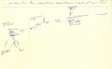
Document - NEW CHUM LINE OF REEF - PLAN OF MINES ALONG PART OF THE NEW CHUM LINE OF REEF
... DOCUMENT Gold New Chum Line Of Reef Plan of Mines along ...Sketch of some mines along the New Chum Line of Reef. Sheet No (178) Caleb Thomas 1879 Jan 29th. Mines mentioned are: Prince Alfred, Victoria Consols, G Lansell's No 83. Some mines are only a number. Victoria Reef Gold Mines are mentioned. Distances in feet or yards between them.document, gold, new chum line of reef, plan of mines along part of the new chum line of reef, caleb thomas, prince alfred mine, victoria consols, g lansell's no 83, ironbark, victoria reef gold mines -
 Bendigo Historical Society Inc.
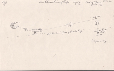
Document - NEW CHUM LINE OF REEF - PART OF A PLAN OF MINES ALONG THE NEW CHUM LINE OF REEF
... DOCUMENT Gold New Chum Line Of Reef Part of a plan of mines ...Sketch of mines along the New Chum Line of Reef Sheet No 1 (811) Caleb Thomas Jun 28, 1879. Mines mentioned are the Hercules and the Energetic. The others are shaft numbers. Measurements between each in feet and yards. Probable course of cap of Victoria Reef drawn in.document, gold, new chum line of reef, part of a plan of mines along the new chum line of reef, caleb thomas, hercules mine, energetic mine, energetic coy -
 Bendigo Historical Society Inc.
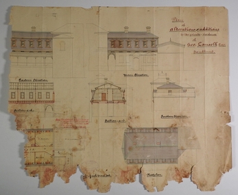
Plan - MARKS COLLECTION: PLAN OF ALTERATIONS AND ADDITIONS TO THE PRIVATE RESIDENCE OF GEO. LANSELL ESQR
Fortuna Villa was owned from 1855 to 1871 by Christopher and Theodore Ballerstedt, Australia’s first mining magnates. In 1871 it was purchased by George Lansell (The Quartz King) being one of Australia’s most successful and adventurous nineteenth century gold mine owners and speculators. Lansell made numerous alterations and extensions to the building. It remained in the Lansell family until 1935Plan for the alteration and additions to Fortuna Villaa, the private residence of George Lansell Plan shows southern, eastern & western elevations, floor and roof plan for the additions to the residence Coloured hand drawn construction plan Plan is undated plan has severe damage on LHS and bottom of the sheetfortuna villa, george lansell, building plans, c & t ballerstedt -
 Bendigo Historical Society Inc.
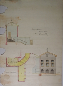
Plan - MARKS COLLECTION: PLAN FOR FOUR LEVEL STAIRCASE TOWER TO GARDEN ELEVATION AT FORTUINA VILLA FOR GEO. LANSELL ESQ
Fortuna Villa was owned from 1855 to 1871 by Christopher and Theodore Ballerstedt, Australia’s first mining magnates. In 1871 it was purchased by George Lansell (The Quartz King) being one of Australia’s most successful and adventurous nineteenth century gold mine owners and speculators. Lansell made numerous alterations and extensions to the building and it remained in the Lansell family until 1935.Plan for four level staircase tower to the Garden Elevation of Fortuna Villa, Sandhurst for George Lansell Esq. Plan details: * Plan shows ground, First, second and third floor plans for the staircase construction * First and second floor house plans and location of staircase addition * Front and Garden elevations with staircase addition Plan coloured and damaged on LHS, also with water damagebendigo fortuna villa, george lansell, building plans, c & t ballerstedt -
 Bendigo Historical Society Inc.
Plan - MARKS COLLECTION: PLAN FOR THE ADDITION OF A FOUR LEVEL STAIRCASE TOWER TO THE GARDEN ELEVATION OF FORTUNA VILLA FOR GEO. LANSELL ESQ
Fortuna Villa was owned from 1855 to 1871 by Christopher and Theodore Ballerstedt, Australia’s first mining magnates. In 1871 it was purchased by George Lansell (The Quartz King) being one of Australia’s most successful and adventurous nineteenth century gold mine owners and speculators. Lansell made numerous alterations extensions to the building and remained in the Lansell family until 1935Plan for the addition of a four level staircase to the Garden Elevation of Fortuna Villa for George Lansell Esq. Plan shows: * Four levels of the staircase cobstructiob - Ground, Principal, First & Second levels of the staircase tower, with viewing walk at the second level * Entrance & garden elevations section showing exterior of the four level additionfortuna villa, george lansell, c & t ballerstedt, building plans -
 Bendigo Historical Society Inc.
Plan - MARKS COLLECTION: PLAN FOR ADDITIONS TO FORTUNA VILLA FOR GEO. LANSELL ESQ. - STAIRCASE ADDITION
Fortuna Villa was owned from 1855 to 1871 by Christopher and Theodore Ballerstedt, Australia’s first mining magnates. In 1871 it was purchased by George Lansell (The Quartz King) being one of Australia’s most successful and adventurous nineteenth century gold mine owners and speculators. Lansell made numerous alterations extensions to the building and remained in the Lansell family until 1935Plan for the addition and necessary modifications of a staircase to Fortuna Villa, the residence of George Lansell Esq. Coloured plan Plan is damaged missing several sections on the LHS of the plan and has water damage in lower LH cornerfortuna villa, lansell, stair case -
 Bendigo Historical Society Inc.
Plan - MARKS COLLECTION: PLAN GARDEN FRONT FORTUNA VILLA SANDHURST - G. LANSELL ESQ., JULY 3RD 1871
Fortuna Villa was owned from 1855 to 1871 by Christopher and Theodore Ballerstedt, Australia’s first mining magnates. In 1871 it was purchased by George Lansell (The Quartz King) being one of Australia’s most successful and adventurous nineteenth century gold mine owners and speculators. Lansell made numerous alterations and extensions to the building and it remained in the Lansell family until 1935. Plan for construction of Fortuna Villa, Sandhurst Title: Garden Front, Fortuna Villa, Sandhurst for G. Lansell Esq. Dated: 3rd July 1871 Coloured plan and elevation Condition: water damage and paper tearsfortuna villa, george lansell, c & t ballerstedt, building plans -
 Bendigo Historical Society Inc.
Document - HUSTLERS REEF - PLANS & SECTIONS TO ACCOMPANY BULLETIN NO 33
Pink page pasted onto cream card titled Plans and Sections to accompany Bulletin No 33. Hustler's Line of Reef, Bendigo by H S Whitelaw, by Authority: Albert J. Mullett, Government Printer, Melbourne. Plate No 1 to No 34. Mines mentioned: Fortuna Hustler's Mine, Hustler's Royal Reserve No 2 Mine, Hustler's Royal Reserve Mine Park Shaft, Great Extended Hustler's Mine, Hustler's Reef and Hustler's Reef No 1 Mines, Hustler's Reef Mine, Comet Mine, United Hustler's and Redan Mine, K. K. Mine, Hustler's Consols Mine, Fortuna Hustler's Mine. Department of Mines Geological Survey of Victoria 1914. Written on the back: Lightning Hill area to Summer Hill.document, hustlers reef, plans & sections to accompany bulletin no 33, geological survey of victoria, department of mines, hustler's line of reef, h s whitelaw, fortuna hustler's mine, hustler's royal reserve no 2 mine, hustler's royal reserve mine park shaft, great extended hustler's mine, hustler's reef mine, hustler's reef no 1 mine, comet mine, united hustler's mine, redan mine, k k mine, hustler's consols mine, fortuna hustler's mine, hustler's consols mine, albert j mullett, government printer melbourne -
 Bendigo Historical Society Inc.
Map - GREAT EXTENDED HUSTLER'S MINE - TRANSVERSE SECTION OF THE GREAT EXTENDED HUSTLER'S MINE
Transverse Section of the Great Extended Hustler's Mine on the Hustler's Line of Reef. Bulletin No 33, Plate No XII. Shows Poppet legs at the surface and Sill of Shaft at 788.99 feet above Sea Level, Cross Cuts and their depths, stone and geographical features encountered and their references and a number of enlarged drawing of sections of the crosscuts, Geological Survey of Victoria emblem and signed by H A Whitelaw, Underground Survey Office Bendigo, September 1913. The depths of crosscuts to No 21 were taken from plans of surveys by Mr. Walker and Mr. Craven, noted under Reference. Another note: This Saddle Reef is sketched from Mr. Walker's plan. Dividends amounting to 360,000 pounds were obtained from it. mining, parish map, great extended hustler's mine, transverse section of the great extended hustler's mine, old shaft, mr walker, mr craven, geological survey of victoria, underground survey office bendigo, h a whitelaw -
 Bendigo Historical Society Inc.
Map - GREAT EXTENDED HUSTLER'S MINE - PLAN OF THE GREAT EXTENDED HUSTLER'S MINE
... GREAT EXTENDED HUSTLER'S MINE - PLAN OF THE GREAT EXTENDED... & Watson's Shaft Plan of the Great Extended Hustler's Mine ...Plan of the Great Extended Hustler's Mine on the Hustler's Line of Reefs, Bendigo. Bulletin No 33, Plate No X. Lease No 7382. Plan has map of streets. Mine was located in the block bounded by Langston and Anderson Streets and was between the Hustler's Anticline at Surface and the Lightning Hill Anticline at Surface. Latham & Watson's Shaft is also mentioned. Levels are numbered and a table shows the Levels and their Depths. Geological Survey of Victoria. Signed by H A Whitelaw, Underground Survey Office, Bendigo, September 1913. This item has not been scanned or photographed.mining, parish map, great extended hustler's mine, hustler's line of reefs, mining lease no 7382, geological survey of victoria, underground survey office bendigo, h a whitelaw, latham & watson's shaft -
 Bendigo Historical Society Inc.
Map - GREAT EXTENDED HUSTLER'S MINE - PLAN OF THE GREAT EXTENDED HUSTLER'S MINE
... GREAT EXTENDED HUSTLER'S MINE - PLAN OF THE GREAT EXTENDED... HUSTLER'S MINE - PLAN OF THE GREAT EXTENDED HUSTLER'S MINE ...Plan of the Great Extended Hustler's Mine. Bulletin No 33, Plate No XI. Shows No 2 Shaft, Latham & Watson's Shaft, levels and their depths and some geographical features. Geographical Survey of Victoria emblem and signed by H A Whitelaw, Underground Survey Office, Bendigo, September 1913. Has reference to photos.mining, parish map, great extended hustler's mine, no 2 shaft, latham & watson's shaft, geological survey of victoria, underground survey office bendigo, h a whitelaw -
 Bendigo Historical Society Inc.
Map - FORTUNA HUSTLER'S MINE - PLAN OF THE FORTUNA HUSTLER'S MINE
... FORTUNA HUSTLER'S MINE - PLAN OF THE FORTUNA HUSTLER'S MINE...MINING Parish Map Fortuna Hustler's Mine Plan ...Plan of the Fortuna Hustler's Mine, Bulletin No 33, Plate No II. Geological Survey of Victoria. Signed by H A Whitelaw, Underground Survey Office Bendigo, September 1913. Map shows levels and depths. There are smaller drawings of some sections of some levels. mining, parish map, fortuna hustler's mine, plan of the fortuna hustler's mine, geological survey of victoria, h a whitelaw, underground survey office bendigo -
 Bendigo Historical Society Inc.
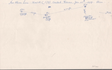
Document - NEW CHUM LINE OF REEF - SKETCH OF MINES ALONG THE NEW CHUM LINE OF REEF
... Sketch of mines along part of the New Chum Line Of Reef...). Caleb Thomas Jan 28th 1879. Plan. Hercules and Energetic Mines ...Sketch of mines along part of the New Chum Line Of Reef. Sheet No 1 (179). Caleb Thomas Jan 28th 1879. Plan. Hercules and Energetic Mines on drawing, 430 feet apart. Albert Richardson Collectiondocument, gold, new chum line of reef, sketch of mines along the new chum line of reef, hercules, energetic, caleb thomas -
 Bendigo Historical Society Inc.
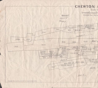
Map - MINING REPORTS - PLAN OF CHEWTON GOLDFIELD 1937
... MAP Mining Reports Plan of Chewton Goldfield Edward Dyason ...Plan of the Chewton Goldfield with Scale Measurement in chains. Plan shows the township of Chewton with the reefs and leases, the railway line and the Main Castlemaine - Melbourne Road. Also, the Eureka Vineyard. Issued by The Stock Exchange of Melbourne, April 1937. Leases named are: Central Wattle Gully, Wattle Gully United, Wattle Gully Extended, South Wattle Gully, Golden Wattle, Chewton, White Horse, Wattle Gully, North Wattle Gully, North Chewton, Upper Barkly, Post Office Hill, Misima United, Argus Hill, Chapmans, Chewton Prospecting Co, Fiji Gold & Gold Mines of Fiji and Nimrod. Stamp in the top right corner: Edward Dyason & Co. - Queen St. Melbourne. Sharebrokers.map, mining reports, plan of chewton goldfield, edward dyason & co, the stock exchange of melbourne, central wattle gully, wattle gully united, wattle gully extended, south wattle gully, golden wattle, chewton, white horse, wattle gully, north wattle gully, north chewton, upper barkly, post office hill, misima united, argus hill, chapmans, chewton prospecting co, fiji gold & gold mines of fiji, nimrod -
 Bendigo Historical Society Inc.
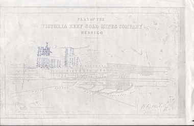
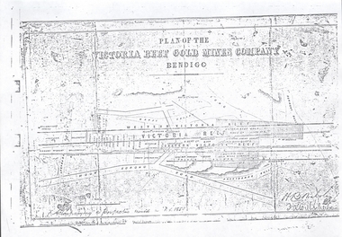
Document - VICTORIA HILL - PLAN OF THE VICTORIA REEF GOLD MINES COMPANY
Plan of the Victoria Reef Gold Mines Company, Bendigo showing the Eastern Victoria Reef, Victoria Reef and the Western Victoria Reef. Streets, gullies and leases drawn in. Some amounts of money and names have been written on the page. Signed by H. B. Nicholas. Locations of Ballerstedt's, Luffsman's, Wittscheibe's, Midway Co and Rae's engines are shown. Ironbark, Derwent, Providence and Long Gullies are shown. Also Mount Korong Road. Leases mentioned are: Jackson, Burrows, Wybarndt, Ballerstedt, Luffsman, Roberts, Ashley, Grant, Troy, Tezeau, Woodward, Croath, Taylor, Cranshaw, Gou?d & Co, Midway, Wittscheibe, Specimen Hill Co, Endeavour, Albert Co, Ballerstedt & Son, Hy? Co, and Wheadon.document, gold, victoria hill, plan of the victoria reef gold mines company, h b nicholas, spiers, jackson, burrows, wybarndt, ballerstedt, luffsman, roberts, ashley, grant, troy, tezeau, woodward, croath, taylor, cranshaw, gou?d & co, midway, wittscheibe, specimen hill co, endeavour, albert co, ballerstedt & son, hy? co, and wheadon -
 Clunes Museum
Document - CONSERVATION PLAN, SHIRE OF HEPBURN, SCHOOL OF MINES, 2000
... SCHOOL OF MINES, CLUNES BRANCH N0.12, FORMED 1886. ALSO ...SCHOOL OF MINES, CLUNES BRANCH N0.12, FORMED 1886. ALSO SUPPORTED LOYAL CLUNES LODGE OF ODDFELLOWS, CLUNES INDEPENDENT ORDER OF RECHABITES, A BRANCH OF AUSTRALIAN WOMEN'S ASSOCIATION. IN 1891 ANA (AUSTRALIAN NATIVES ASSOCIATION) 1935 CWA, INNERSPRING MATTRESS FACTORY, CLUNES, INFANT WELFARE, CLUNES ANGLING CLUB NOW OCCUPIES THE BUILDING.SPIRAL BOUND DOCUMENT WITH THE FORMER CLUNES SCHOOL OF MINES DEPICTED IN COLOUR ON THE FRONT PAGE. CONTAINS A CONSERVATION MANAGEMENT PLAN WITH HISTORICAL DETAIL AND COLOURED PHOTOGRAPHS OF THE BUILDING AND SURROUNDSlocal history, conservation management plan, school of mines -
 Bendigo Historical Society Inc.
Plan - Great Extended Hustlers, April, 2014
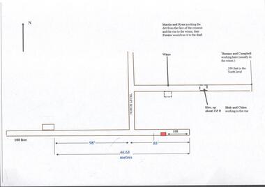
Seven men were killed at the Great Extended Hustler's mine disaster on 2nd May 1914 by an explosion of dynamite occurring as the men were waiting at the plat to ascend the mine at the end of their shift. No blame was attached to anyone in the findings of the inquisition. It was unknown what caused the dynamite to explode. This document formed part of the research done at the time by Bendigo Historical Society, of the 100 years commemoration of the mine disaster, held at Hustler's Hill in 2014. One page plan, computer generated, annotated to show the worksite of the miners prior to when the explosion occurred at the Great Extended Hustlers mine in May 1914. The location of Martin, Ryan, Thomas, Campbell, Blair and Chinn are described. great extended hustlers, goldmining, accident, 1914 -
 Bendigo Historical Society Inc.
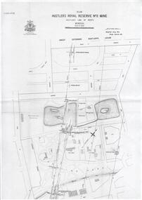
Plan - Hustler's Royal Reserve No. 2 Mine, April, 2014
One page plan (photocopy) of Hustler's Royal Reserve No. 2 Mine (Park Shaft) showing mine location, dams, tennis courts, bowling green, Jail (sic) Barnard Street, View Street and Park Road. Whitelaw plan, 1913.goldmining, accident, quartz, mining, hustler's royal reserve no. 2 mine, park shaft, hustler's line of reef, gaol, -
 Bendigo Historical Society Inc.
Document - Geological Survey of Victoria, Hustlers Line of Reef, Bendigo, April, 2014
Seven men were killed at the Great Extended Hustler's mine disaster on 2nd May 1914 by an explosion of dynamite occurring as the men were waiting at the plat to ascend the mine at the end of their shift. No blame was attached to anyone in the findings of the inquisition. It was unknown what caused the dynamite to explode. This document formed part of the research done at the time by Bendigo Historical Society, of the 100 years commemoration of the mine disaster, held at Hustler's Hill in 2014. Seven page photocopy of Department of Mines, Bulletin, Geological Survey of Victoria, Hustlers Line of Reef, Bendigo, No. 33 by H.S. Whitelaw. Includes plan of Hustlers Royal Reserve No. 2, (main shaft) showing location on Pall Mall, and location of Post Office and Law Courts; plan of location of Hustlers Royal Reserve No. 2 (Park Shaft) showing Jail (sic), Camp Hill State School, two 'lagoons' in between tennis court, croquet court and bowling green; a plan of the Great Extended Hustler's Shaft and two copied images of Hustler's Hill showing mining buildings, poppet heads and chimneys. Comet, K.K., Hustler's No. 1, Old Comet and United Hustler's and Redan Mines are shown in the images. great extended hustlers, goldmining, accident, quartz, mining, k.k. mine, comet mine, hustler's line of reef, old comet, united hustler's, redan -
Bendigo Historical Society Inc.
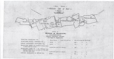
Document - Hustlers Line of Reef, Bendigo, South Portion, April, 2014
Seven men were killed at the Great Extended Hustler's mine disaster on 2nd May 1914 by an explosion of dynamite occurring as the men were waiting at the plat to ascend the mine at the end of their shift. No blame was attached to anyone in the findings of the inquisition. It was unknown what caused the dynamite to explode. This document formed part of the research done at the time by Bendigo Historical Society, of the 100 years commemoration of the mine disaster, held at Hustler's Hill in 2014. One page photocopy of plan of mining leases on the south portion of the Hustlers Line of Reef. Written underneath plan 'Wood & McNair, Sharebrokers, Beehive Chambers, Bendigo'. Fortuna Hustlers Co., Hustlers Royal Reserve No 2; Great Extended Hustlers Co., Hustlers Reef Co., Hustlers Reef No. 1 and United Hustlers & Redan Co. showing shares held and length of lease are listed on page. great extended hustlers, goldmining, accident, 1873 -
 Bendigo Historical Society Inc.
Document - VICTORIA HILL - VICTORIA HILL AND NEW CHUM HILL
Typed notes on Victoria Hill and New Chum Hill. Notes give location, value of gold and plans for a mining museum.document, gold, victoria hill, victoria hill and new chum hill, john neil macartney, the age, the australasian, bendigo goldfields registry 1871, victoria reef quartz mine, north old chum, victoria consols, new chum and victoria, pioneer, lansell 222 mine, lazarus, barnet lazarus, mt. alvernia hospital, fortuna villa, george lansell, a. h. q. survey regiment, central red white and blue, hudsons, burrowes & sterry, b c v channel 8, bendigo and district tourist association, section 14 of the lands act 1958, mr a r richardson, cr t r flood, tourist association -
 Bendigo Historical Society Inc.
Document - VICTORIA HILL - PLAN OF THE VICTORIA REEF GOLD MINES COMPANY BENDIGO
3587.70 same as 3587.69. Copied onto smaller white paper.map, bendigo, victoria hill, plan of the victoria reef gold mines company bendigo -
 Bendigo Historical Society Inc.
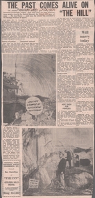
Newspaper - VICTORIA HILL - VICTORIA HILL NEWSPAPER ARTICLE
Two copies of newspaper articles titled ''The Past Comes Alive on 'The Hill'' from the Bendigo Advertiser dated 3/7/1971. Some history, a guided tour by two busloads of students and some plans are mentioned in the article. There are also two photos in the article. In one photo three Rotarians of Bendigo South, Mr. Vic Wodetski, Mr. Jack Bright and Mr. A. E. Richardson are inspecting some of the concentric rings of iron oxide and the quartz spur running through the centre of the outcrop on Victoria Hill. In the other photo Mr. jack Bright is looking at the natural curves of colour in the stone of Victoria Hill.newspaper, bendigo advertiser, victoria hill, victoria hill newspaper article, central deborah, victoria hill open cut, joss house, bendigo potteries, mr a e richardson, bendigo historical society, mr j hattam, reservoir high school, mr w j derham, rotary club of bendigo south, bendigo and district tourist association, victoria quartz mine, george lansell's big 180, theodore ballerstedt, goldmines hotel