Showing 1427 items matching "outer"
-
 Glenelg Shire Council Cultural Collection
Accessory - Badge - Vote 6, n.d
Round metal pin badge. Dark green centre, white 16'; 'vote' one side of number 'six' the other. Outer border light green, black print 'Victoria's Referendum'. This was in regards to 6 o'clock closing for pubs and hotels.victorian referendum, politics, democracy, 6 o clock swill -
Warrnambool RSL Sub Branch
Web Belt, Military Uniform
Worn by Army soldiers as part of field and dress uniform during WW2 Donated by Ruby Annett from the Caramut RSL. Probably at the time of wind up of the Caramut RSL Sub Branch. Webbing BELT, with brass ends that fold inwards to clip to the inside of the belt. The fastening is a brass hook fastening and there are two brass keepers that are positioned on the belt just inside the buckle and have both the inner and outer folds that pass through the keepers. -
 Flagstaff Hill Maritime Museum and Village
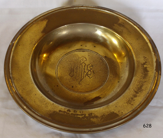
Ceremonial object - Plate, circa 1943
This plate, a polished brass altar salver, is part of the original furnishings of St Nicholas Church, Williamstown, Victoria. The church was operated by the Missions to Seamen organisation. The plate is sometimes called a salver, a paten or a communion plate. It is used for serving the communion bread. The plate was presented to the Mission to Seamen, in memory of Kenneth Wyatt McVilly, who passed away on December 4th 1943. The letters on the lip of the plate, A.D.G., stand for the Greek Alpha Delta Gamma, and are used to represent "For the Glory of God". THE MISSIONS TO SEAMEN (Brief History: for more, see our Reg. No. 611, Set of Pews) The Missions to Seamen, an Anglican charity, has served seafarers of the world since 1856 in Great Britain. It symbol is a Flying Angel, inspired by a Bible verse. Today there are centr4es in over 200 ports world-wide where seamen of all backgrounds are offered a warm welcome and provided with a wide range of facilities. In Victoria the orgainsation began in Williamstown in 1857. It was as a Sailors’ Church, also known as ‘Bethel’ or the ‘Floating Church’. Its location was an old hulk floating in Hobson’s Bay, Port of Melbourne. It soon became part of the Missions to Seamen, Victoria. In the year 2000 the organisation, now named Mission to Seafarers, still operated locally in Melbourne, Portland, Geelong and Hastings. The Ladies’ Harbour Lights Guild was formed in 1906 to support the Missions to Seamen in Melbourne and other centres such as Williamstown. Two of the most significant ladies of the Guild were founder Ethel Augusta Godfrey and foundation member Alice Sibthorpe Tracy (who established a branch of the Guild in Warrnambool in 1920). The Guild continued its work until the 1960s. In 1943 a former Williamstown bank was purchased for the Missions to Seaman Club. The chapel was named St Nicholas’ Seamen’s Church and was supported by the Ladies’ Harbour Lights Guild, the Williamstown Lightkeepers’ Auxiliary and the League of Soldiers’ and Sailors’ Friends. It ceased operation in 1966. A Missions to Seamen Chapel and Recreation Room was a significant feature of ports during the late 1800s and into the 1900s. It seemed appropriate for Flagstaff Hill to include such a representation within the new Maritime Village, so the Melbourne Board of Management of Missions to Seamen Victoria gave its permission on 21st May 1979 for the entire furnishings of the Williamstown chapel to be transferred to Flagstaff Hill. The St Nicholas Seamen’s Church was officially opened on October 11, 1981 and closely resembles the Williamstown chapel. This memorial plate is significant as it is associated with a member of the community, Kenneth McVilly, and was presented in his memory after he died in o1943. This plate is significant historically for its origin in the St Nicholas Mission to Seamen's Church in Williamstown, established in 1857 to cater for the physical, social, and spiritual needs of seafarers. It originated in Bristol, England when a Seamen's Mission was formed in 1837. Plate, polished brass altar salver, or communion plate. It is round with decorative initials in the centre. Outer lip has an inscription of dedication to Kenneth Wyatt McVilly, December 4th 1943. This plate is in our St Nicholas Seamen's Church Collection. “A.D.G. / and in memory of / KENNETH WYATT MCVILLY / December 4th 1943” and initials "I H S"flagstaff hill, warrnambool, shipwrecked coast, flagstaff hill maritime museum, maritime museum, shipwreck coast, flagstaff hill maritime village, great ocean road, religion, church furnishings, mission to seamen victoria, st nicholas church williamstown, brass plate, kenneth wyatt mcvilly, altar salvar, religious service, memorial plate, altar salver, communion plate, paten, communion service, a d g -
 Bendigo Historical Society Inc.
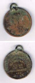
Medal - INDIAN PACKET TEA MEDAL
Indian Packet Tea Medal: Medallion advertising Indian packet Tea. Round medallion with inscription, outer edge SSAM & DARJEELING TEAS. Inner circle ÍNDIAN PACKET TEAS ARE THE STRONGEST AND BEST' Female figure on the back. Box 625numismatics, medals - civil, indian packet tea. -
 Bendigo Historical Society Inc.
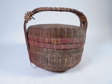
Container - CHINESE FOOD BASKET, 1890s
Large round rattan Chinese food basket with lid and handle (6.5 cm).Double layer of woven can and bamboo, inner section in herringbone pattern and outer layer in horizontal pattern. Red and green decoration around the basket and on the handle.domestic equipment, food storage & preservation, chinese -
 Victorian Apiarists Association
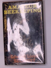
Publication, Amateur Beekeeping (Edward LLoyd Sechrist) Second Edition, 1976
A5 Hardcover book with a browny orange under cover. Outer cover has a dark picture of a Queen cell. Title is in Yellow writing, author is in orange writing. On the back are listed books & descriptions published by Robert Hale 156 pagesOn the inside front cover is a blurb about the book. The inside back cover is a blurb about the author -
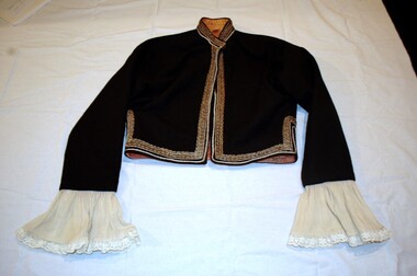 Plutarch Project
Lady's dancing costume Jacket, Γιλέκο στολής βλαχοπούλας
The full costume used traditionally by ladies in the 16th to 19th century AD. Now used in Greek dances, parades and theatrical performances as a traditional costume.Historical significance due to the variety of traditional functions it was used during the 1990'sLady's dancing costume Jacket, gold and silver embroidery around edges. It has orange lining of silk material, lace and linen frill sleeve. Whole costume is called "Vlahopoula". Velvet outer. Part "C" of a four piece costume.lady's costume, jacket, greek, βλαχοπούλα, γιλέκο, στολή -
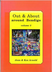 Bendigo Historical Society Inc.
Book - Out & About around Bendigo Volume 3
BHS CollectionOrange outer edge with yellow insert black writing inset of photos Lockwood State School, Maldon photos and Kangaroo Chair Tarnagulla. Back page map of area and various photos. Author Jean and Ken Arnold - 96 Pagesblack and white photos plaques, maps -
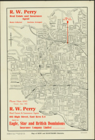 Kew Historical Society Inc
Map - Map of Kew and Hawthorn Districts
Map of Kew, East Kew and Hawthorn produced for a Kew Real Estate Agent, RW Perry. The map is undated.Two-colour map of Kew and Hawthorn Districts produced for by R.L. Jarrett for RW Perry, Real Estate & Insurance Agent. The map has unusual features such as a planned railway link from Kew Station to the former Outer Circle Railway. RW Perry / Real Estate & Insurance Agent, 602 High Street, East Kewmaps - kew (vic), maps - hawthorn (vic), r.w. perry, real estate agents -- kew (vic.) -
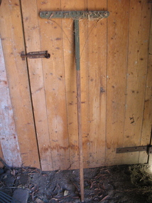 Friends of Westgarthtown
Rake
Wooden rake with long handle and wooden head. Head and part of handle have been painted green. 16 nails added to wooden head to form rake teeth. Wire running from outer sides of rake head to handle.No visible markings.rural industry, agriculture, rake, wood, nails, handmade. -
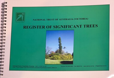 Beechworth Honey Archive
Publication, Register of Significant Trees (National Trust Of Australia (Victoria)), 11/3/2010
Soft Cover, around A5 size horizontal, has been spiral bound, has a clear plastic cover to protect inner cover. White outer with green inner & photo of a Captain Cook Pine, black writing 66 pages -
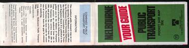
 Melbourne Tram Museum
Document, Ministry of Transport, Melbourne Public Transport Map - No. 12, 1982
Map No. 12 - Includes description of tram and bus routes, private bus routes. On the front cover is composite image of Melbourne public transport vehicles. Has contact details for bookings and lost property etc and how to use the map. Priced at 40c, issue No. 12 of c1982. Has details of the then new Travelcard ticket system. Yields information about Melbourne public transport services in 1982.Fold out map (36 sections 9 across x 4 deep), "Public Transport Map", coloured of Melbourne's Tram and Bus routes, route numbers, rail lines, detailed for the central part of Melbourne and the outer Metropolitan services.tramways, melbourne, tram services, bus services, railways, travelcard -
 Melbourne Tram Museum
Map, Ministry of Transport, Melbourne Public Transport Map - No. 9, 1979
Map No. 9 - Includes description of tram and bus routes, private bus routes. Has contact details for bookings and lost property etc and how to use the map. Yields information about Melbourne public transport services in 1979Fold out map (27 sections 9 across x 3 deep), "Public Transport Map", coloured of Melbourne's Tram and Bus routes, route numbers, rail lines, detailed for the central part of Melbourne and the outer Metropolitan services.tramways, melbourne, tram services, bus services, railways, travelcard, maps -
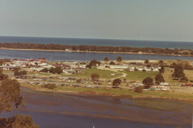
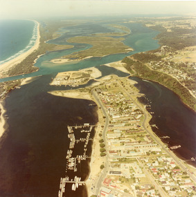 Lakes Entrance Historical Society
Photograph - Lakes Entrance, 1980c
Colour photograph aerial view of township of Lakes Entrance, showing western end of town, Bullock Island, Cunninghame Arm and North Arm, man made entrance, and distant view of outer barrier, island and shoreline. Lakes Entrance Victoriawaterways, township, bridges -
 Melbourne Tram Museum
Map, Ministry of Transport, Melbourne Public Transport Map - No. 11, 1980
Map No. 11 dated on rear as 1980 - Includes description of tram and bus routes, private bus routes. Has contact details for bookings and lost property etc and how to use the map. Yields information about Melbourne public transport services in 1980Fold out map (27 sections 9 across x 3 deep), "Public Transport Map", coloured of Melbourne's Tram and Bus routes, route numbers, rail lines, detailed for the central part of Melbourne and the outer Metropolitan services.tramways, melbourne, tram services, bus services, railways, maps -
 Melbourne Tram Museum
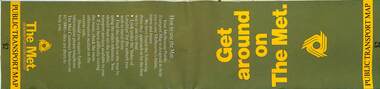
Map, The Met, Public Transport Map - Get around on The Met, c1987
Undated map - c1987 - Neighbourhood and travelcard tickets, has a photo of the front of B2 2004, includes a map of the travelcard neighbourhoods, commuter passes and The Met contact details.Yields information about Melbourne public transport services in c1987Fold out map (36 sections 9 across x 4 deep), "Public Transport Map", coloured of Melbourne's Tram and Bus routes, route numbers, rail lines, detailed for the central part of Melbourne and the outer Metropolitan services.tramways, melbourne, tram services, bus services, railways, maps, travelcard, neighbourhood tickets -
 Melbourne Tram Museum
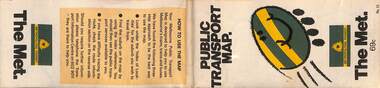
Map, The Met, "Public Transport Map - No. 13", 1984
Map No. 13 undated with the buzzing bee symbol on the front and throughout at the time of the introduction of the neighbourhoods. Includes description of tram and bus routes, private bus routes. Has contact details for bookings and lost property etc and how to use the map. Gives extensive details of the neighbourhood tickets and their used. C1984.Yields information about Melbourne public transport services in 1984.Fold out map (36 sections 9 across x 4 deep), "Public Transport Map", coloured of Melbourne's Tram and Bus routes, route numbers, rail lines, detailed for the central part of Melbourne and the outer Metropolitan services.tramways, melbourne, tram services, bus services, maps -
 Melbourne Tram Museum
Map, Public Transport Corporation (PTC), "Public Transport Map of Melbourne", 5/1995
Map Includes description of tram and bus routes, private bus routes, and rail lines. Has contact details for bookings and lost property etc and how to use the map. Gives details of the ticketing system, along with photographs of the various modes. Dated May 1995 with a stylised image of some of Melbourne's landmarks on the cover. Published by the Public Transport Corporation.Yields information about Melbourne public transport services in 1995.Fold out map (36 sections 9 across x 4 deep), "Public Transport Map", coloured of Melbourne's Tram and Bus routes, route numbers, rail lines, detailed for the central part of Melbourne and the outer Metropolitan services.tramways, melbourne, tram services, bus services, maps, railways -
 Bendigo Military Museum
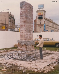
Photograph - CENOTAPH RESTORATION WORKS, C. 1987 - 88
This is the fifth in a series beginning with Cat No 8255 relating the progress towards the restoration of the Bendigo Cenotaph over the Bendigo Creek.Three photographs all colour A4 size. .1) Shows the Bendigo Cenotaph stripped of its outside cladding leaving the internal brick structure. .2) Shows the outer cladding going back on. .3) Shows the cenotaph near finished. brsl, smirsl, cenotaph, bendigo -
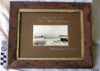 Flagstaff Hill Maritime Museum and Village
Photograph - Vessel, Sailing Ship, Falls of Halladale, After 13-11-1908
Falls of Halladale The Falls of Halladale was a four-masted sailing ship built-in 1886 in Glasgow, Scotland, for the long-distance cargo trade and was mostly used for Pacific grain trade. She had a sturdy construction built to carry maximum cargo and able to maintain full sail in heavy gales, one of the last of the ‘windjammers’ that sailed the Trade Route. She was one of the first vessels to include fore and aft lifting bridges, which kept the crew safe and dry in as they moved around the decks in stormy conditions. She was owned by Wright, Breakenridge & Co of Glasgow and was one of several Falls Line ships, all of which were named after waterfalls in Scotland. On 4th August 1908, with new sails, 29 crew, and 2800 tons of cargo, the Falls of Halladale left New York, bound for Melbourne and Sydney via the Cape of Good Hope. The cargo on board was valued at £35,000 and included 56,763 tiles of American slate roofing tiles, 5,673 coils of barbed wire, 600 stoves, 500 sewing machines, 6,500 gallons of oil, 14,400 gallons of benzene, plumbing iron, 117 cases of crockery and glassware and many other manufactured items. The Falls of Halladale had been at sail for 102 days when, at 3 am on the of 14th November 1908, under full sail in calm seas with a six knots breeze behind and misleading fog along the coast, the great vessel rose upon an ocean swell and settled on top of a submerged reef near Peterborough on south-west Victoria’s coast. The ship was jammed on the rocks and began filling with water. The crew launched the two lifeboats and all 29 crew landed safely on the beach over 4 miles away at the Bay of Islands. The postmistress at Peterborough, who kept a watch for vessels in distress, saw the stranding and sent out an alert to the local people. A rescue party went to the aid of the sailors and the Port Campbell rocket crew was dispatched, but the crew had all managed to reach shore safely by the time help arrived. The ship stayed in full sail on the rocky shelf for nearly two months, attracting hundreds of sightseers who watched her slowly disintegrate until the pounding seas and dynamiting by salvagers finally broke her back, and her remains disappeared back into deeper water. The valuable cargo was largely lost, despite two salvage attempts in 1908-09 and 1910. Further salvage operations were made from 1974-1986, during which time 22,000 slate tiles were recovered with the help of 14 oil drums to float them, plus personal artefacts, ship fittings, reams of paper and other items (a list of items held at Flagstaff Hill Maritime Village is included below). The Court of Marine Inquiry in Melbourne ruled that the foundering of the ship was entirely due to Captain David Wood Thomson’s navigational error, not too technical failure of the Clyde-built ship. The shipwreck is a popular site for divers, about 300m offshore and in 3 – 15m of water. Some of the original cargo can be seen at the site, including pieces of roof slate and coils of barbed wire. The Falls of Halladale shipwreck is listed on the Victorian Heritage Register (No. S255). She was one of the last ships to sail the Trade Routes. She is one of the first vessels to have fore and aft lifting bridges. She is an example of the remains of an International Cargo Ship and also represents aspects of Victoria’s shipping industry. The wreck is protected as a Historic Shipwreck under the Commonwealth Historic Shipwrecks Act (1976).Photograph of the wrecked ship, the Falls of Halladale, sails still flying. The ship was wrecked at Peterborough on Nov 13, 1908. The outer frame is made from a piece of planking. Handwritten inscriptions in white ink on the top of the matt board, and on the lower right.BQE "Falls of Halladale" "Wrecked. Peterborough. Nov 13. 1908" "Frame. from piece of planking."flagstaff hill, warrnambool, shipwrecked-coast, flagstaff-hill, flagstaff-hill-maritime-museum, maritime-museum, shipwreck-coast, flagstaff-hill-maritime-village, shipwreck, photograph, falls of halladale, planking frame -
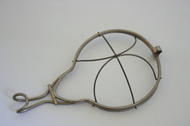 Geoffrey Kaye Museum of Anaesthetic History
Equipment - Mask, Wire
Wire framed face mask with a hinged outer layer which can be opened to insert gauze or flannel on which to administer ether. The domed portion is attached by inserting wire edges into slots in the rim, which ends in a handle with a loop at the end.mask, ether, anaesthesia, open method -
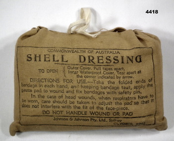 Bendigo Military Museum
Equipment - SHELL DRESSING, Johnson and Johnson PTY LTD, October 1941
Shell dressing, rectangular shape, rounded edges, khaki colour, all text in black print, consists of outer cover, inner water proof cover, gauze bandage and safety pin, text is about how to apply the bandage to wounds.shell dressing, accessory, wounds, military -
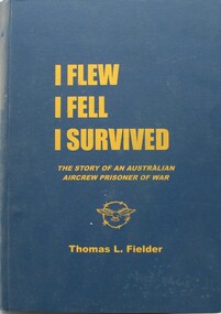 Ringwood RSL Sub-Branch
Book - RAAF WW2, I Flew I Fell I Survived. Story of an Australia Aircrew Prisoner of War, 2001
Self published by Tom Fielder ex RAAF. Baled out from a Wellington Bomber over Italy and spent the rest of the War as a prisoner of the Germans. Hard Carboard outer, Paper, Text and Pictures. 393 pages. Tom Fielder CollectionEx P.O.W 270030. Stalag IVB, Germany, Muhlberg. -
 Lakes Entrance Historical Society
Photograph - Boat ramp on North Arm Lakes Entrance Victoria, G W Holding, 1/04/1979 12:00:00 AM
Taken during King of the Straits power boat race Colour photograph taken from Kalimna Heights showing cars parked at boat ramp on North Arm rear entry to the Club Hotel Club Spit Cunninghame Arm outer barrier and Bass Strait in distance Lakes Entrance Victoria waterways, parks, boats and boating, boat ramp, houses, hotels, events -
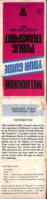
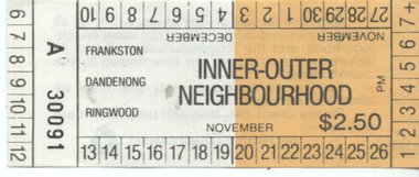 Melbourne Tram Museum
Ephemera - Inner-Outer Neighbourhood ticket, The Met, 11/1983
Sample of the first ticket issue in the Neighbourhood system priced at $2.50, has the conditions of use on the rear. See reference for background. The outer neighbourhood was punched by the ticket clerk at the station. Could be used on trams in the inner neighbourhood. The Neighbourhood system commenced on 13/11/1983 and this ticket has that commencement date.Demonstrates an early neighbourhood ticket used in Melbourne.ticket - two colours printed on white paper No. 30091tickets, the met, neighbourhood tickets -
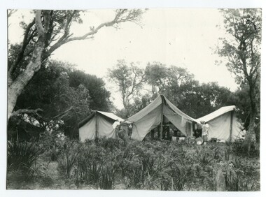 Orbost & District Historical Society
black and white photograph, first half 20th century
This photograph is linked with photograph 1168. Orbost locals have been taking camping holidays at East Cape since at least the early 20th century. From the mid-1940s about a dozen huts were located there, mostly by locals from the Orbost area, to establish what was known as the 'Conran Settlement' or 'Conran Community'. These huts were subject to permissive occupancy laws which were invoked by the State Labor Government to force their removal in 1986. (Wikipedia)Orbost locals have been camping at Cape Conran since at least the early 20th century. This campsite is from a time before Cape Conran Coastal Park a 11,700 hectare area was declared a coastal park under the National Parks Act in 1997 and camping areas were formalised.A black / white photograph showing three large tents side by side in a bush setting. The middle tent is open and set up as a kitchen and the outer two appear to be sleeping quarters. There is fishing equipment against the middle tent - nets and tin tubs.on back - " Camping at C. Conran"cape-conran recreation-camping -
 Warrnambool and District Historical Society Inc.
Plate, Warrnambool Congregational Church, Early to mid 20th century
This plate was probably part of a crockery set used by the Warrnambool Congregational Church for church functions and receptions. The Warrnambool Congregational Church began when two men, Robert Winton and Thomas Nayler, met in 1862 to discuss the possibility of establishing a church of the Independent order. As a result the first Congregational Church was opened in Liebig Street, Warrnambool in 1864 with William Pentland as the first Minister. Samuel Nettleton was a notable member of the congregation, being the Superintendent of the Sunday School for 60 years. In 1940 the Congregational Church moved to a building in Henna Street and in 1973 the Congregational Church merged with the Methodist Church to form what is known today as the Uniting Church. In 1976 the former Congregational Church building in Henna Street was sold to the Salvation Army. This plate is of interest as a memento of the Warrnambool Congregational Church, an institution that no longer exists under that name. This is a cream-coloured china plate with a gold trim around the outer edges and the name of the church in the centre in a black and white scroll pattern. The gold trim is now almost obliterated. The edges of the plate are chipped in several places and the plate is much stained and blotched. ‘Warrnambool Congregational Church’ congregational church, warrnambool, history of warrnambool -
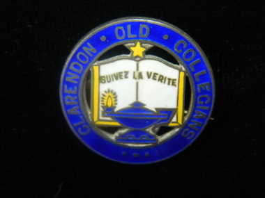 Ballarat Clarendon College
Badge, Clarendon Old Collegians
The Clarendon Old Collegians Association existed from very early times in the school history and was a singificant controbutor to school socail capacity and infrastructure. The OC's regularly donated funds and purchases to special projects. Sections of the society met in different geographic areas, such as Melbourne or the Wimmera. Three circular enamel brooches featuring outer circle in royal blue with lettering enclosing features of school crest - open book in white with gold border, royal blue lamp with gold flame at base of book and gold star at top of bookLettering around border: CLARENDON OLD COLLEGIANSclarendon-presbyterian-ladies-college, clarendon-old-collegians -
Glenelg Shire Council Cultural Collection
Souvenir - Souvenir - Volunteer Air Observers Corps Badge, 1939-1945
Belonged to Thomas EverettMetal circular badge with cord and safety pin. Badge has blue outer border with text volunteer Air Observers Corps in gold. White inner band with text "observer' in gold. Inner red circle with gold bird with outstretched wings.Front: Volunteer Air Observers Corps Observer, gold enamel Back: This badge is the property of the Dept. of Air. 16993 Stokes -
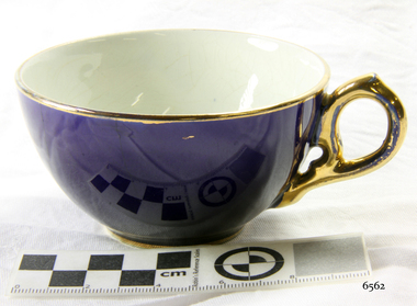 Flagstaff Hill Maritime Museum and Village
Ceramic - Teacup, 1920s
This teacup is part of a four-piece place setting, comprising a teacup, saucer and plates, from a tea set. The tea set was given by Eva Carmichael, a survivor of the ship Loch Ard which was wrecked near Port Campbell in 1878, to Jane Shields, the young woman who supported Eva during her recovery from the ordeal. Ms Shields was Eva’s close companion while she was convalescing at Glenample Homestead. The friendship between the two women continued after Eva Carmichael returned to her home in Britain, became Mrs Townsend, and had three sons. Jane Shields also married, becoming Mrs John Osborne and bearing four daughters and two sons. In 1926-27, almost forty-eight years after the shipwreck, one of Jane’s daughters (Ella Marie Schulby nee Osborne) visited Eva in England. Eva gave her the tea set to take back home to her mother. Jane died in 1932 and her tea set was inherited by her daughters, who divided it between themselves, a four-piece place setting for each of them. A brief history of the Loch Ard: - The Loch Ard was named after a Scottish lake. It was one of the famous Loch Line of ships that sailed the long voyage from England to Australia. Barclay, Curdle and Co. built the three-masted iron ship in Glasgow in 1873. It had sailed three trips to Australia and one trip to Calcutta before its fateful voyage. Loch Ard left England on March 2, 1878, under the command of recently married, 29-year-old Captain Gibbs, bound for Melbourne with a crew of 37, plus 17 passengers. The general cargo reflected the affluence of Melbourne at the time. Onboard were straw hats, umbrellas, perfumes, clay pipes, pianos, clocks, confectionery, linen and candles, and a heavier load of railway irons, cement, lead and copper. Other cargo included items intended for display in the Melbourne International Exhibition of 1880. The Loch Ard had been sailing for three months and was close to its destination. At 3 am on June 1, 1878, Captain Gibbs expected to see land, but the Loch Ard ran into a fog that greatly reduced visibility. Captain Gibbs became anxious as there was no sign of land or the Cape Otway lighthouse. The fog lifted at 4 am. A lookout announced that he could see breakers. The sheer cliffs of Victoria's west coast came into view; the ship was much closer to them than Captain Gibbs expected. It was not long before the Loch Ard's bow swung towards land. Although the Captain tried to manage the vessel, his attempts didn’t work and the ship struck a reef at the base of Mutton Bird Island, near Port Campbell. The top deck became loosened from the hull, and the masts and rigging crashed down, knocking passengers and crew overboard. The lifeboat was launched by Tom Pearce but crashed into the side of Loch Ard and capsized. Tom Pearce managed to cling to the lifeboat’s overturned hull and shelter beneath it. He drifted out to sea and the tide brought him back to what is now called Loch Ard Gorge. He swam to shore and found a cave for shelter. A passenger, Eva Carmichael, had raced onto the deck to find out what was happening and was confronted by towering cliffs above the ship. She was soon swept off the ship by a huge wave. Eva saw Tom Pearce on a small rocky beach and yelled to attract his attention. He swam to the exhausted woman and dragged her to shore and to the shelter of the cave. He revived Eva with a bottle of brandy from a case that had washed up on the beach. Tom scaled a cliff in search of help and followed some horse hoof prints. He came from two men from Glenample Station, three and a half miles away. He told the men of the tragedy and then returned to the gorge while the two men rode back to the station to get help. They reached Loch Ard Gorge and took the two shipwreck survivors to Glenample Station to recover. Eva stayed at the station for six weeks before returning to Ireland by steamship. In Melbourne, Tom Pearce received a hero's welcome and was presented with a medal and some money. Of the 54 crew members and passengers on board, only two survived: the apprentice, Tom Pearce and the young woman passenger, Eva Carmichael, who lost her family in the tragedy.This blue china tea set, comprising a teacup, saucer and two plates, is of high significance as it is closely connected to the wreck of the Loch Ard, and to one of only two survivors, Eva Carmichael. Memorabilia connected to Eva Carmichael are precious and rare. The Loch Ard shipwreck is significant for Victoria and is registered on the Victorian Heritage Register (S 417). Flagstaff Hill has a varied collection of artefacts from Loch Ard and its collection is significant for being one of the largest accumulations of artefacts from this notable Victorian shipwreck. The group gives a snapshot of history, enabling us to interpret the story of this tragic event and the lives of the people involved. The collection is also archaeologically significant as it represents aspects of Victoria's shipping history that allow us to interpret Victoria's social and historical themes of the time. The collection's historical significance is that it is associated unfortunately with the worst and best-known shipwreck in Victoria's history.The teacup is part of a china tea set place setting, which comprises the teacup, a saucer and two plates of slightly different sizes. The cup is a royal blue outer, white inside with gold lip, a gold ring around the base and a gold handle. flagstaff hill, warrnambool, flagstaff hill maritime museum and village, shipwreck coast, great ocean road, china tea set, tea set, royal blue china, tom pearce, eva carmichael, jane shields, glenample, loch ard, place setting, teacup