Showing 16995 items
matching plenty-river
-
 Eltham District Historical Society Inc
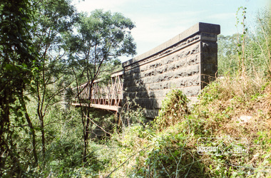
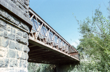
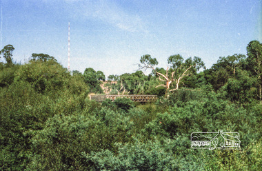
Negative - Photograph, Old Lower Plenty Bridge, c.Mar. 1983
Roll of 35mm colour negative film, 4 stripsKodak Safety 5035lower plenty bridge -
 Eltham District Historical Society Inc
Negative - Photograph, Old Lower Plenty Bridge, c.Mar. 1983
Roll of 35mm colour negative film, 4 stripsKodak Safety 5035lower plenty bridge -
 Eltham District Historical Society Inc
Negative - Photograph, Old Lower Plenty Bridge, c.Mar. 1983
Roll of 35mm colour negative film, 4 stripsKodak Safety 5035lower plenty bridge -
 Eltham District Historical Society Inc
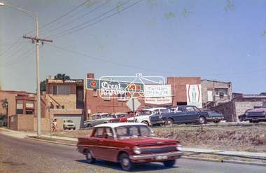
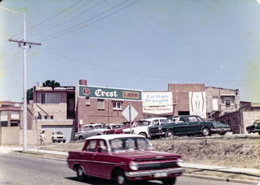
Photograph, Rear view of Lower Plenty shops from Para Road, c.1976, 1976c
Streetscape development over timeRoll of 35mm colour negative film, 2 stripsAgfa CNSpara road, lower plenty, shops, shoe inn, maunder's food store -
 Eltham District Historical Society Inc
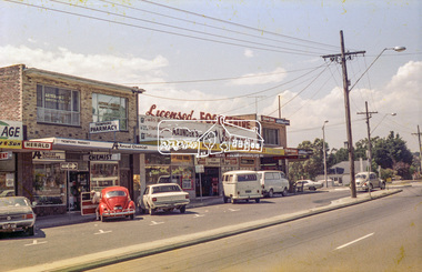
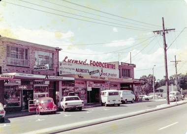
Photograph, Lower Plenty shops, Main Road, c.1976, 1976c
Streetscape development over timeRoll of 35mm colour negative film, 2 stripsAgfa CNSlower plenty, shops, main road, shoe inn, maunder's food store -
 Eltham District Historical Society Inc
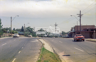
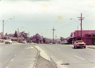
Photograph, Para Road and Main Road, Lower Plenty, c.1976, 1976c
Streetscape development over timeRoll of 35mm colour negative film, 2 stripsAgfa CNSpara road, lower plenty, shops, main road, shoe inn, maunder's food store -
 Eltham District Historical Society Inc
Photograph, Para Road and Main Road, Lower Plenty, c.1976, 1976c
Streetscape development over timeColour photographpara road, lower plenty, shops, main road -
 Eltham District Historical Society Inc
Photograph, Rear view of Lower Plenty shops from Para Road, c.1976, 1976c
Streetscape development over timeColour photopgraphpara road, lower plenty, shops -
 Eltham District Historical Society Inc
Photograph, Lower Plenty shops, Main Road, c.1976, 1976c
Streetscape development over timeColour photographlower plenty, shops, main road -
 Eltham District Historical Society Inc
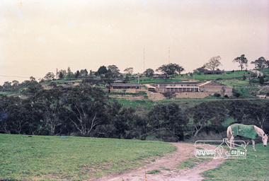
Photograph, Believed to be in the region of Cleveland Avenue, Lower Plenty, c.1980s, 1980s
Roll of 35mm colour negative film, 3 stripsKodacolor IIlower plenty, radio transmission tower, cleveland avenue -
 Eltham District Historical Society Inc
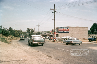
Photograph, Intersection of Para Road with Main Road, Lower Plenty, c.1965, 1965c
Digital file only; created from original colour positive slide transparencystreets, lower plenty, main road, para road, shops, maunder's food store, russell yeoman collection, shoe inn, maunder's food store -
 Eltham District Historical Society Inc
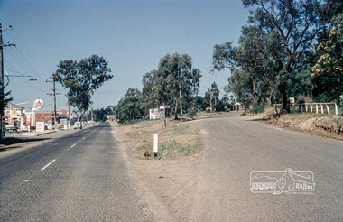
Photograph, Russell Yeoman, Intersection of Old Eltham Road at Main Road, Lower Plenty, c.1965, 1968
Digital file only; created from original colour positive slide transparencystreets, main road, lower plenty, old eltham road, russell yeoman collection -
 Eltham District Historical Society Inc
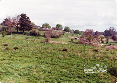
Photograph, Believed to be in the region of Banyule Flats, Lower Plenty, c.1980s, 1980s
Colour photographlower plenty, radio transmission tower -
 Eltham District Historical Society Inc
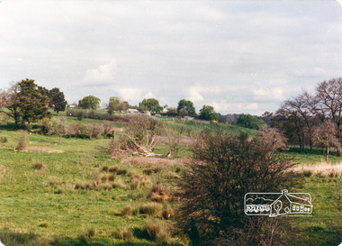
Photograph, Believed to be in the region of Banyule Flats, Lower Plenty, c.1980s, 1980s
Colour photographlower plenty, radio transmission tower -
 Eltham District Historical Society Inc
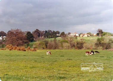
Photograph, Believed to be in the region of Banyule Flats, Lower Plenty, c.1980s, 1980s
Colour photographlower plenty, radio transmission tower -
 Australian Commando Association - Victoria
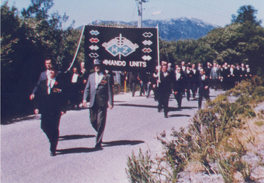
Photograph, Inaugural march of M& Z Commando Association members at The Australian Commando Memorial at Tidal River 16 November 1964
The WW2 Commando memorial cairn was unveiled at Tidal River on 15 November 1964 by the Lieutenant Governor of Victoria Lieutenant General Sir Edmund Herring. Former WW2 Commandos march under their Association banner to the cairn for the dedication ceremony.This was the first dedication of a significant WW2 Commando memorial. The Victorian Governor, Lieutenant General Sir Edmund Herring, unveiled the Commemorative Cairn that has become the de facto national Commando memorial.Rectangular colour glossy print photograph of former WW2 Commandos marching at Tidal River.From Don Bergmanww2, world war ii, australian commandos, independent companies, australian commando association, tidal river, wilsons promontory national park -
 Wodonga & District Historical Society Inc
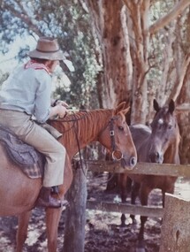
Album - Ringer's River by Des Martin - Plate 8 - O'Day meets Grapeshot
Pushing his mob along the back boundary of Barmagulla Station, whose owner, Edmund Montieth, a wealthy, well educated, and forward thinking gentleman accepted as a leader of the N.S.W. pastoralists "just across the border", O'Day hears the shrill whinny of a stallion. On riding over to investigate he finds that, in the practise of the day, a superb thoroughbred horse has been turned out on the river flats to acclimatise. Later he learns that this is Grapeshot, a classic winner just imported from England.The albums and images are significant because they document literature written by a prominent member of the Wodonga community. The presentation of this precis was supported by several significant district families and individuals.Ringer's River Album Coloured photo Plate 8des martin, many a mile, ringer's river, northeast victoria stories -
 Sunbury Family History and Heritage Society Inc.
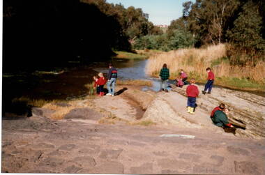
Photograph, River studies
Students from Bulla Primary school were taken to the nearby Deep Creek to study some of the river life inn the local water course.Bulla township is situated in the Deep Creek valley and was an ideal place to take students to study river life close to their school.A coloured photograph of eight children with two adults standing on a rocky outcrop beside a river and looking at the riverlife in the water.rivers, deep creek, river studies, bulla, bulla primary school -
 Greensborough Historical Society
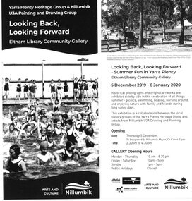
Leaflet, Looking Back, Looking Forward, 2019
Advertising leaflet for a display of historical photographs and paintings depicting "Summer fun in Yarra Plenty". The display ran from 05/12/2019 until 06/01/2020 at the Eltham Library Community Gallery and was organised by Yarra Plenty Heritage Group with paintings from the Nillumbik U3A Drawing and Painting Group. Greensborough Historical Society had 3 photographs in the display.1 page leaflet, black and white text and images. 2 copies.yarra plenty heritage group, yarra plenty regional library, nillumbik u3a -
 Eltham District Historical Society Inc
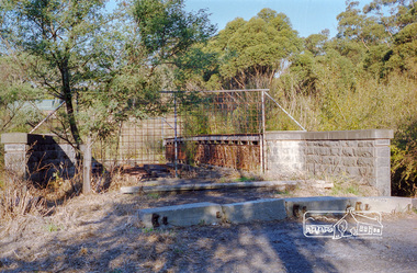
Negative - Photograph, Old Lower Plenty Bridge, 18 Apr 1998
EDHS Autumn excursion to Lower Plenty area The blocked-off iron bridge at Lower Plenty - now re-opened and used as a footway/bike path section joining the Yarra River path.Roll of 35mm colour negative film, 2 strips and associated colour printKodak Gold 200-6activities, lower plenty bridge, autumn excursion, eltham district historical society, lower plenty -
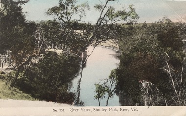 Kew Historical Society Inc
Postcard, The VSM.Series, No.351. River Yarra, Studley Park, Kew, Vic, c.1905
This is a colour postcard of the River Yarra at Studley Park, circa 1905. The postcard, which has handwritten notes on the reverse. It was printed in Prussia as part of the Victoria Stamp Market (VSM) Series. Coloured postcard of the Yarra River looking north from Galatea Point, near the Johnson Street Bridge.Donated by Miss B. Challen. ?Taken from bend above Galatea Point, looking north. Identified by Darcy Dugan, Yarra Bend Parks.river yarra, victoria stamp market (vsm) series, postcards -
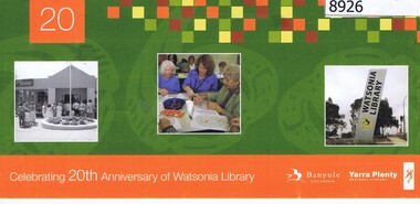 Greensborough Historical Society
Flyer - Invitation, Yarra Plenty Regional Library, Celebrating 20th anniversary of Watsonia Library, 08/11/2008
Watsonia Library is part of Yarra Plenty Rergional Library, operating over Banyule, Nillumbik and Whittlesea Local Government areasCardboard invitation, printed in colour both sidesAddressed to Rosie Bray in handwritingyarra plenty regional library, watsonia library -
 Orbost & District Historical Society
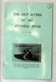
book, James Yeates & Sons (Printing) Pty Ltd, The Silk Jetties of the Mitchell river, 1972
This booklet was the first of a series of scientific and historical studies of Gippsland to be published by the Bairnsdale Advertiser. The author, Eric Charles Frederick Bird was Principal Fellow, Department of Geography, University of Melbourne, Australia. The Mitchell River silt jetties are an unusually long, thin landform located in the Gippsland Lakes region. They have been formed over millions of years by sediment deposition from the Mitchell River during periods of low water flow and subsequent wash-through during periods of high water flow. The long narrow banks of silt extend more than eight kilometres east into Lake King. This item is a useful reference for the silt jetties of the Mitchell River.A 32 pp book with alight green cover. The title is in black print, " The Silk Jetties of the Mitchell River" and underneath the title there is a b/w photograph of the Mitchell River and silt jetties taken from above in 1931. It was written by E. C. F. Bird.silt-jetties mitchell-river paynesville bird-e.c.f. -
 Ballarat Heritage Services
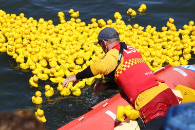
Digital photographs, L.J. Gervasoni, Moyneyana Ducks, c2013
Each new year's day there is a duck race at Port Fairy on the Moyne River. Colour photograph of rubber ducks in the Moyne River on new year's day. landscape, river, moyneyana, duck race, fundraiser, slsc, surf life saving club, port fairy, rubber ducks, moyne river -
 Otway Districts Historical Society
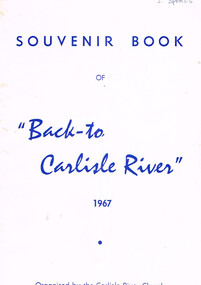
Book, "Back to Carlisle River", 1967
The settlement and settlers of Carlisle River, first known as "New Church Run" in 1861 until its name change in 1890-91.Souvenir bbok of "Back to Carlisle River", 1967. Colac (Vic); Herald Print; 1967. 25 p.; illus. Soft cover.Under Hotel, an insertion entitled "The Carlisle Hotel" containing the names of the licencees until its surrender on 31 December 1928.carlisle river; new chuch run; butter; history; sport; -
 Vision Australia
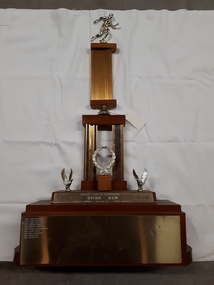
Photograph - Image, River Run Female Winner trophy
A race along the banks of the Yarra River (?) this trophy was awarded to the female winners from 1978-1987. A golden running figure sits atop a pedestal that rests on a bell located above two pedestals behind a golden laurel wreath. Two eagles, with wings outstretched as if just landing, are either side of the wreath and the inscription 'Rotary Club of Glenferrie - River Run - Female winner - Donated by Bob Bruner' is written on the plinth below them. On the base plinth are inscribed the names of the previous winners: 1978 Lynne Williams 1979 Lynne Williams 1980 Lynne Williams 1981 Dorothy Browne 1982 Dorothy Browne 1983 Michelle Baumgarten 1984 Laura Dess 1985 Mary Edwards 1986 Julie McKie 1987 Julie McKieGold running figure atop two levels of columns with a wreath and two eagles at the base, whereupon names are inscribedRotary Club of Glenferrie River Run Female Winner Donated by Bob Brunerassociation for the blind, awards -
 Orbost & District Historical Society
plan, before 1948
Drainage infrastructure was developed and maintained in this region by the Snowy River Improvement Trust. The Trust was administered by a local committee and its activities funded by a local rate charged on the farmers and land owners in the Trust’s designated district. The level of the rate charged by the Trust was designed to be proportionate to the benefit derived from the works undertaken. Financial assistance was provided by the State Government from time to time for specific projects such as post flood repairs but not for new capital works. The Trust undertook new drainage and river management works including tree planting, rock beach construction and servicing of the drains and flood gates. The Trust also provided a personal flood warning service to the farmers in its district. The Trust ceased to operate in 1997 with the advent of the East Gippsland Catchment Management Authority. The infrastructure developed by the Trust continues to provide a service to the farmers in the region. (ref. 4 East Gippsland CMA Submission to Inquiry into Flood Mitigation Infrastructure in Victoria) This plan is significant as a historical document. The Snowy River Improvement Trust was vital to the Orbost district because of its ability to apply local knowledge and to engage the local farming community.A large plan of divisions of land for the purpose of levying the Snowy River Improvement District - Bete Bolong, Orbost, Waygara, Newmerella and Orbost East. The properties are coloured according to levy amount. The scale is 1" - 20 chains. snowy-river-improvement-trust -
 Orbost & District Historical Society
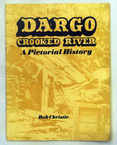
book, Enterprise Press Pty Ltd, Dargo Crooked River, C 1994-1997
This is a pictorial history of the Crooked River district.This is a useful reference tool on the history of gold mining in the Dargo area.A thin 56 pp paperback book titled,"Dargo Crooked River a Pictorial History". On the yellow front cover is a sepia photograph of a man standing outside a rough wooden hut. The title and author are printed in black text over this. The book contains Black / white photographs and the history of Dargo and Crooked River. The information is divided int decades. Inside there is a newspaper cutting of Victorian cattlemen on Junction Plain near Omeo.dargo-crooked-river gold-mining east-gippsland-history -
 Port Fairy Historical Society Museum and Archives
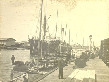
Photograph, 1906
Iron Steamship Casino in the Moyne River 1906B&W photograph of the SS Casino moored in the Moyne River opposite the lifeboat shedship, boat, sea, river, casino -
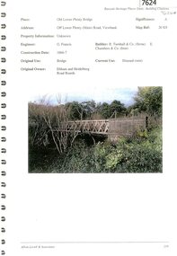 Greensborough Historical Society
Document - Document Collection, Allom Lovell & Associates, Old Lower Plenty Bridge, 2001
Heritage citation for the Old Lower Plenty Bridge, copied from Banyule Heritage Places Study; a short history of the bridge and a news clipping, dated 2001 reporting on the re-opening of the bridge as a link in the Plenty River Trail.4 p., illus. Heritage citation, 2p.; history of bridge, 1p.; newspaper clipping, 1p. plenty river, plenty river trail, old lower plenty bridge, lower plenty