Showing 113952 items matching "road-making"
-
 Whitehorse Historical Society Inc.
Document, Electing members of the District Road Board, 1862
Copy from Ivan Southall''s 'A Tale of Box Hill', public meeting for the election of members of the Nunawading District Road Board, for fixing the rate for the current year and appointing auditors.Copy from Ivan Southall''s 'A Tale of Box Hill', public meeting for the election of members of the Nunawading District Road Board, for fixing the rate for the current year and appointing auditors. Extract from Road Board minute book, 10 Sept 1862.Copy from Ivan Southall''s 'A Tale of Box Hill', public meeting for the election of members of the Nunawading District Road Board, for fixing the rate for the current year and appointing auditors.local government, nunawading district roads board -
 Ringwood and District Historical Society
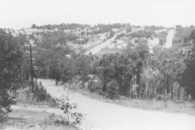
Photograph, Laying pipeline near Mt. Dandenong Road, in Whitehorse Road, Ringwood (undated)
Written on back of photograph, "Laying pipeline near Mt. Dandenong Road, in Whitehorse Road". -
 Sunbury Family History and Heritage Society Inc.
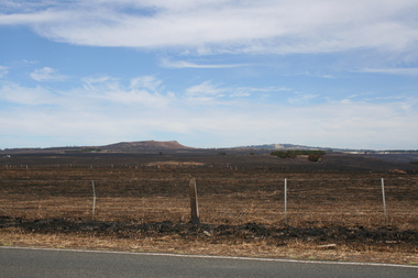
Photograph, Rosa McCall, Riddell Road, February 2014
In February 2014 severe grassfires blazed across the land north of Sunbury from the Calder Highway across Riddell Road and on to Clarkefield and beyond and caused damage to the Bendigo Railway line. This image was taken about a week later along Riddell Road and looking SW to Red Rock across the skyline.This grass fire caused much damage across a large area north of Sunbury and beyond.A coloured photograph of an open landscape that has been extensively burnt after grassfires.grass fires, riddell road, red rock, sunbury -
 Eltham District Historical Society Inc
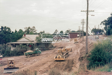
Photograph, Main Road widening, Eltham, c.March 1968, 1968
Immediately prior to duplication of Main Road. Gahan house on left and Shire Offices in background35mm Colour positive transparency Mount - Agfacolor Service (Blue stepped)duplication, eltham, eltham shire office, gahan house, main road, road construction -
 Eltham District Historical Society Inc
Photograph, Main Road widening, Eltham, c.March 1968, 1968
Duplication of Main Road. Gahan House almost completely demolished. Shillinglaw Cottage on right.35mm Colour positive transparency Mount - Agfacolor Service (Blue stepped)duplication, gahan house, main road, shillinglaw cottage -
 Eltham District Historical Society Inc
Photograph, Main Road widening, Eltham, c.March 1968, 1968
Duplication of Main Road. Gahan House almost completely demolished. Shillinglaw Cottage on right.35mm Colour positive transparency Mount - Agfacolor Service (Blue stepped)duplication, gahan house, main road, road construction, shillinglaw cottage -
 Greensborough Historical Society
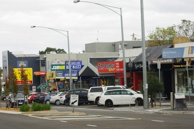
Photograph - Digital image, Marilyn Smith, Watsonia Road shopping strip, 2016, 24/05/2016
Watsonia Road shopping strip, Watsonia 2016. The strip is managed by the Watsonia Traders Association.Digital copy of colour photograph.watsonia, watsonia road -
 Greensborough Historical Society
Photograph - Digital image, Marilyn Smith, Watsonia Road shopping strip 2, 2016, 24/05/2016
Watsonia Road shopping strip, Watsonia 2016. The strip is managed by the Watsonia Traders Association.Digital copy of colour photograph.watsonia, watsonia road -
 Eltham District Historical Society Inc
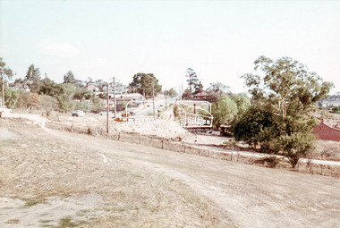
Photograph, Looking south along Main Road from just north of Elsa Court, Eltham, February 1968, Feb 1968
Shows where the future duplication of Main Road ends just north of Elsa Court.In February 1968 an unknown person took a series of photos from the Eltham Hotel at Pitt Street heading north along Main Road through the shopping centre to just north of Elsa Court covering the length of the section of Main Road which was duplicated shortly thereafter. Shows the condition and environment of the streesscape of Main Road, Eltham immediately prior to the duplication between Pitt Street and Elsa Court through the shopping centre. Also shows a number of shops and businesses that operated at that time.Black and white photographduplication, eltham, main road, elsa court, railway line -
 Eltham District Historical Society Inc
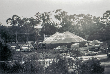
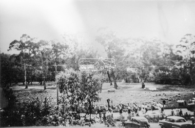
Slide - Photograph, Grace Mitchell, Ashtons Circus set up in Bremner's Reserve, Main Road, Eltham, c.1955
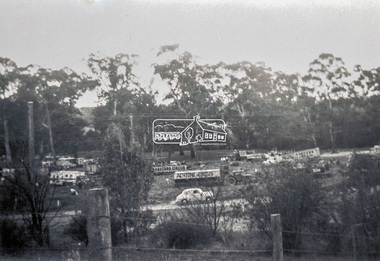
View from Grace Mitchell's shop at the corner of Mount Pleasant Road and Main Road. Grace Mitchell was probably best known for her Eltham shop at the corner of Mt Pleasant Road and Main Road. Grace's memories covered many local identities who were patrons of her shop between 1954 and 1971. From the elevated position of her shop and home Grace was able to view a varied passing parade of Eltham events from ERSILAC, Easter and Eltham Festival parades passing on their way to Eltham Lower Park, circuses in Wingrove Park (then Bremner’s Reserve), roadworks and other happenings. Bremner's Reserve was renamed Wingrove Park c.1970 This photo was from a series of images presented by Grace Mitchell at a Society talk 10 March 1993 on the theme of “My Eltham”.35mm Kodak 5052 TMX Black and White transparency, 1 strip, 6 frames Black and white print 17 x 25.4 cmashtons circus, bremner's flat, circus, grace mitchell, main road, mount pleasant road, wingrove park -
 Eltham District Historical Society Inc
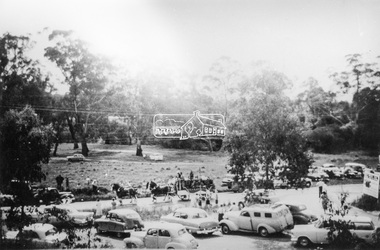
Slide - Photograph, Grace Mitchell, Ashtons Circus set up in Bremner's Reserve, Main Road, Eltham, c.1955
View from Grace Mitchell's shop at the corner of Mount Pleasant Road and Main Road. Grace Mitchell was probably best known for her Eltham shop at the corner of Mt Pleasant Road and Main Road. Grace's memories covered many local identities who were patrons of her shop between 1954 and 1971. From the elevated position of her shop and home Grace was able to view a varied passing parade of Eltham events from ERSILAC, Easter and Eltham Festival parades passing on their way to Eltham Lower Park, circuses in Wingrove Park (then Bremner’s Reserve), roadworks and other happenings. Bremner's Reserve was renamed Wingrove Park c.1970 This photo was from a series of images presented by Grace Mitchell at a Society talk 10 March 1993 on the theme of “My Eltham”.35mm Kodak 5052 TMX Black and White transparency, 1 strip, 6 frames Black and white print 17 x 25.4 cmashtons circus, bremner's flat, circus, grace mitchell, main road, mount pleasant road, wingrove park -
 Eltham District Historical Society Inc
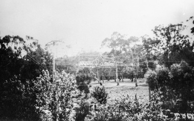
Photograph, Grace Mitchell, Bremners Flat, Main Road, Eltham, 1958c
View from Grace Mitchell's shop at the corner of Mount Pleasant Road and Main Road. Grace Mitchell was probably best known for her Eltham shop at the corner of Mt Pleasant Road and Main Road. Grace's memories covered many local identities who were patrons of her shop between 1954 and 1971. From the elevated position of her shop and home Grace was able to view a varied passing parade of Eltham events from ERSILAC, Easter and Eltham Festival parades passing on their way to Eltham Lower Park, circuses in Wingrove Park (then Bremner’s Reserve), roadworks and other happenings. Bremner's Reserve was renamed Wingrove Park c.1970 This photo was from a series of images presented by Grace Mitchell at a Society talk 10 March 1993 on the theme of “My Eltham”.Black and white print 17 x 25.4 cmbremner's flat, main road, mount pleasant road, wingrove park -
 Eltham District Historical Society Inc
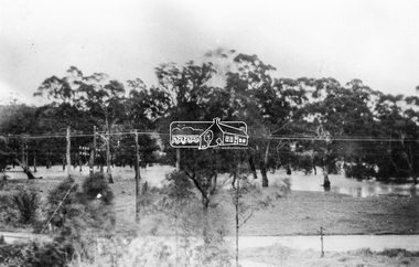
Photograph, Grace Mitchell, Diamond Creek in flood, Bremners Flat, Main Road, Eltham, c.1958
View from Grace Mitchell's shop at the corner of Mount Pleasant Road and Main Road. Grace Mitchell was probably best known for her Eltham shop at the corner of Mt Pleasant Road and Main Road. Grace's memories covered many local identities who were patrons of her shop between 1954 and 1971. From the elevated position of her shop and home Grace was able to view a varied passing parade of Eltham events from ERSILAC, Easter and Eltham Festival parades passing on their way to Eltham Lower Park, circuses in Wingrove Park (then Bremner’s Reserve), roadworks and other happenings. Bremner's Reserve was renamed Wingrove Park c.1970 This photo was from a series of images presented by Grace Mitchell at a Society talk 10 March 1993 on the theme of “My Eltham”.Black and white print 17 x 25.4 cmbremner's flat, diamond creek, floods, main road, mount pleasant road, wingrove park -
 Eltham District Historical Society Inc
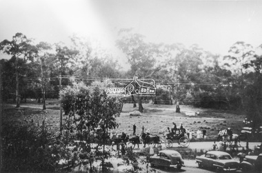
Photograph, Grace Mitchell, Possibly the Ersilac Parade travelling along Main Road, Eltham, c.1958
View from Grace Mitchell's shop at the corner of Mount Pleasant Road and Main Road. Grace Mitchell was probably best known for her Eltham shop at the corner of Mt Pleasant Road and Main Road. Grace's memories covered many local identities who were patrons of her shop between 1954 and 1971. From the elevated position of her shop and home Grace was able to view a varied passing parade of Eltham events from ERSILAC, Easter and Eltham Festival parades passing on their way to Eltham Lower Park, circuses in Wingrove Park (then Bremner’s Reserve), roadworks and other happenings. Bremner's Reserve was renamed Wingrove Park c.1970 This photo was from a series of images presented by Grace Mitchell at a Society talk 10 March 1993 on the theme of “My Eltham”.Black and white print 17 x 25.4 cmcars, bremner's flat, eltham, ersilac parade, main road, mount pleasant road, wingrove park, festival, horse drawn carriage -
 Eltham District Historical Society Inc
Photograph, Grace Mitchell, Possibly the Ersilac Parade travelling along Main Road, Eltham, 1958c
View from Grace Mitchell's shop at the corner of Mount Pleasant Road and Main Road. Grace Mitchell was probably best known for her Eltham shop at the corner of Mt Pleasant Road and Main Road. Grace's memories covered many local identities who were patrons of her shop between 1954 and 1971. From the elevated position of her shop and home Grace was able to view a varied passing parade of Eltham events from ERSILAC, Easter and Eltham Festival parades passing on their way to Eltham Lower Park, circuses in Wingrove Park (then Bremner’s Reserve), roadworks and other happenings. Bremner's Reserve was renamed Wingrove Park c.1970 This photo was from a series of images presented by Grace Mitchell at a Society talk 10 March 1993 on the theme of “My Eltham”.Black and white print 17 x 25.4 cmcars, bremner's flat, eltham, ersilac parade, main road, mount pleasant road, wingrove park, festival, horse drawn carriage -
 Eltham District Historical Society Inc
Photograph, Grace Mitchell, Possibly the Ersilac Parade travelling along Main Road, Eltham, c.1958
View from Grace Mitchell's shop at the corner of Mount Pleasant Road and Main Road. Grace Mitchell was probably best known for her Eltham shop at the corner of Mt Pleasant Road and Main Road. Grace's memories covered many local identities who were patrons of her shop between 1954 and 1971. From the elevated position of her shop and home Grace was able to view a varied passing parade of Eltham events from ERSILAC, Easter and Eltham Festival parades passing on their way to Eltham Lower Park, circuses in Wingrove Park (then Bremner’s Reserve), roadworks and other happenings. Bremner's Reserve was renamed Wingrove Park c.1970 This photo was from a series of images presented by Grace Mitchell at a Society talk 10 March 1993 on the theme of “My Eltham”.Black and white print 17 x 25.4 cmcars, bremner's flat, eltham, ersilac parade, main road, mount pleasant road, wingrove park, festival, horse drawn carriage -
 City of Moorabbin Historical Society (Operating the Box Cottage Museum)
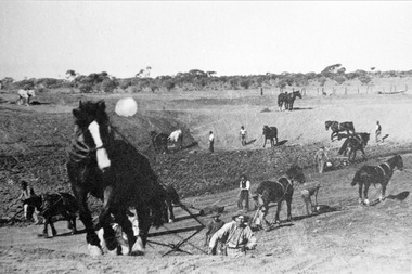
Photograph, Black & White Horse drawn scoops earthwork in Moorabbin Shire c1900, c1900
The, horse drawn metal scoop ,guided by a man, was used to clear earth for road making. Well before the introduction of motorised, mechanical graders and trucks the painstaking, labour-intensive work was undertaken by large teams of sturdy men using strong horses such as the draught horse. Roads were needed by the market gardeners to transport their produce to market. Later as the heavy wagon loads continually caused ruts and general degradation of the roadways a Plateway system was installed so that the wagon wheels could roll along the rails thus protecting the roadways. August 31st 2021 Ron Nash, from WA, informs us "The men and horses pulling earth scoops in the photo are not moving earth for road making - they are excavating an "earth tank", or dam, as described in common nomenclature today. This skill was known as "tank sinking", and tank sinkers were active in many rural and remote areas in the 1800's and early 1900's, establishing sizeable dams for important water reserves for community and farm and railway use. With the advent of mechanised equipment such as bulldozers, the trade of tank sinking was still carried out, but on a faster basis. I am a former tank sinker and earth moving contractor, now long retired." Early settlers in Moorabbin Shire had to build the roads, plateways, drains, as the settlement of the land, in Dendy's Special Survey 1841 Brighton, spread and market gardeners need to transport their produce to market. Their most valuable possession was the draught horse that was used for ploughing, drawing carts and these scoops.Black & White photograph showing many horses pulling metal scoops guided by men to move earth for road making in Moorabbin Shire c 1900Back Handwritten Informationplateway, roadworks moorabbin shire, draught horses, metal scoops, paviers, box alonzo, smith j l; chaff cutter, horse drawn carts, toll gates brighton, motor cars 1900, steam engines, early settlers, bentleigh, mckinnon, parish of moorabbin, city of moorabbin, county of bourke, moorabbin roads board, shire of moorabbin, henry dendy's special survey 1841, were j.b.; bent thomas, o'shannassy john, king richard, charman stephen, highett william, ormond francis, maynard dennis, market gardeners, vineyards, orchards -
 Eltham District Historical Society Inc
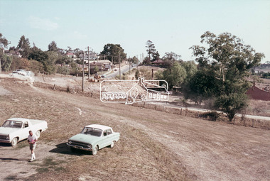
Photograph, Looking west from Main Road from just north of intersection with Diamond Street, Eltham, February 1968, Feb 1968
The watercourse passes under the road and railway at this point. Significant flash flooding occurred along this water course on Christmas Day 2011 causing significant damage to the railway line and road and flooding of Judge Book Village. The drain was swept away including the support pillars of the rail lines timber framework. Judge Book Village had some 40 units flooded before the water entered Diamond Creek. The water had flowed down and flooded Valonia Drive then Grove Street before flowing down the watercourse to Main RoadIn February 1968 an unknown person took a series of photos from the Eltham Hotel at Pitt Street heading north along Main Road through the shopping centre to just north of Elsa Court covering the length of the section of Main Road which was duplicated shortly thereafter. Shows the condition and environment of the streesscape of Main Road, Eltham immediately prior to the duplication between Pitt Street and Elsa Court through the shopping centre. Also shows a number of shops and businesses that operated at that time.Black and white photographduplication, eltham, main road, diamond street, watercourse, drainage, railway line -
 Ringwood and District Historical Society
Photograph, View of Glenvale Road, Ringwood. Warnes Road in left background 1964
See Also #25Written on back of photograph, "1964 - View of Glenvale Road. Supplied by Garrett Gundry. Warnes Road in left background. Deep Creek Road in centre background." -
 Whitehorse Historical Society Inc.
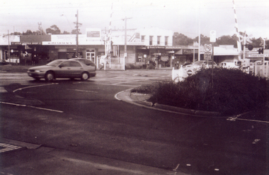
Photograph, Railway crossing on Springvale Road, 1/06/2009
One of a collection of photographs taken of the Nunawading Railway Station prior to the lowering of the railway line and building of the new railway station on the western side of Springvale Road so that the Springvale Road Rail Crossing can be eliminated.Black & white photograph of the precinct surrounding the Nunawading Station and the Springvale Road Railway crossing. This photograph is the railway crossing with Springvale Road, Nunawading, taken from the north west corner looking over crossing to some of the Nunawading shops. See NP 3545 to NP3567 for the complete set of photographsnunawading railway station, springvale road nunawading, redevelopment of railway line/springvale road., nunawading recreation centre -
 Eltham District Historical Society Inc
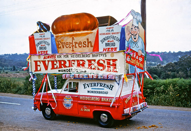
Photograph, Heidelberg Bakery display, Ersilac Parade, Main Road, Eltham, c.1960, 1960c
Heading south along Main Road approaching Bridge Street. Registration GIB is c.1955Digital file only (Wes's 35mm)don muir collection, heidelberg bakery display, ersilac parade, main road, eltham, c.1960 -
 Greensborough Historical Society
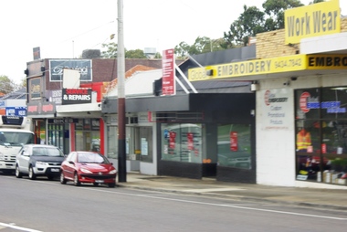
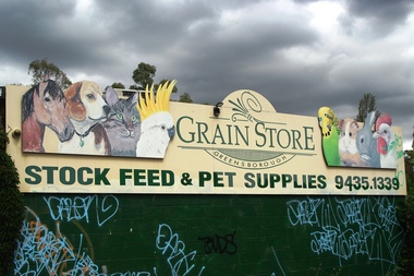
Photograph - Digital Image, Marilyn Smith, Greensborough Grain Store, 183 Para Road. Signs, 06/11/2017
This photograph shows signage at 183 Para Road when the building was used for Greensborough Grain Store.Digital copy of colour photographgreensborough grain store, para road greensborough -
 Greensborough Historical Society
Photograph - Digital Image, Marilyn Smith, Greensborough Grain Store, 183 Para Road. Exterior, 06/11/2017
This photograph shows the exterior of the building at 183 Para Road when it was used for Greensborough Grain Store.In 2017, the Greensborough Grain Store closed its Para Road premises and now trades online.Digital copy of colour photographgreensborough grain store, para road greensborough -
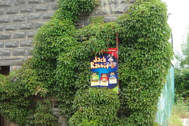
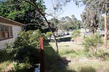
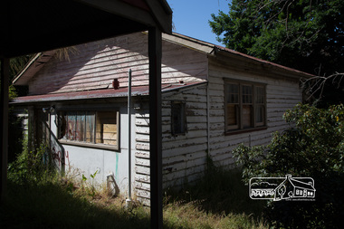
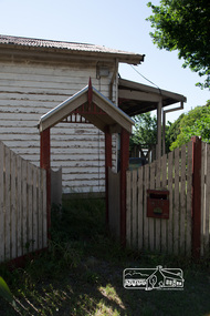
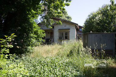
 Eltham District Historical Society Inc
Photograph, Peter Pidgeon, Derelict house, 528 Main Road, Eltham, 13 November 2017, 13/11/2017
House dates back to early 1930s. Situated adjacent to intersection of Main Road and Fitzsimons LaneBorn Digitaleltham, streets, main road, fitzsimons lane -
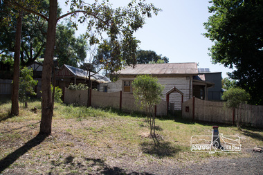
 Eltham District Historical Society Inc
Photograph, Peter Pidgeon, Derelict house, 528 Main Road, Eltham, 13 November 2017, 13/11/2017
House dates back to early 1930s. Situated adjacent to intersection of Main Road and Fitzsimons LaneBorn Digitaleltham, streets, main road, fitzsimons lane -
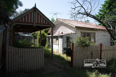
 Eltham District Historical Society Inc
Photograph, Peter Pidgeon, Derelict house, 528 Main Road, Eltham, 13 November 2017, 13/11/2017
House dates back to early 1930s. Situated adjacent to intersection of Main Road and Fitzsimons LaneBorn Digitaleltham, streets, main road, fitzsimons lane -
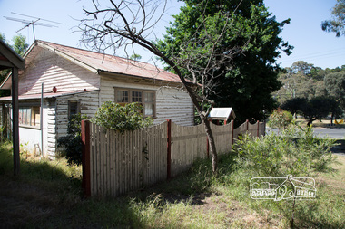
 Eltham District Historical Society Inc
Photograph, Peter Pidgeon, Derelict house, 528 Main Road, Eltham, 13 November 2017, 13/11/2017
House dates back to early 1930s. Situated adjacent to intersection of Main Road and Fitzsimons LaneBorn Digitaleltham, streets, main road, fitzsimons lane -
 Eltham District Historical Society Inc
Photograph, Peter Pidgeon, Derelict house, 528 Main Road, Eltham, 13 November 2017, 13/11/2017
House dates back to early 1930s. Situated adjacent to intersection of Main Road and Fitzsimons LaneBorn Digitaleltham, streets, main road, fitzsimons lane -
 Eltham District Historical Society Inc
Photograph, Peter Pidgeon, Derelict house, 528 Main Road, Eltham, 13 November 2017, 13/11/2017
House dates back to early 1930s. Situated adjacent to intersection of Main Road and Fitzsimons LaneBorn Digitaleltham, streets, main road, fitzsimons lane -
 Eltham District Historical Society Inc
Photograph, Peter Pidgeon, Derelict house, 528 Main Road, Eltham, 13 November 2017, 13/11/2017
House dates back to early 1930s. Situated adjacent to intersection of Main Road and Fitzsimons LaneBorn Digitaleltham, streets, main road, fitzsimons lane