Showing 38468 items
matching scout-camp-wall-creek
-
 Falls Creek Historical Society
Plan - Leases of part of Falls Creek Tourist Area
Bob (Herman) Hymans (a former member of the Royal Netherlands Navy was born in Bloemendaal, Holland on 30th September 1922. During World War II he fought against the Japanese in the Dutch East Indies (now Indonesia) and was imprisoned in Changi and on the Burma Railway. After gaining qualifications as a Ski Instructor, Bob arrived in Falls Creek in May 1950. Working as an Instructor and Supervisor at Bogong Lodge, Bob decided his future was in accommodation. He was successful in negotiating an indenture for land from the State Electricity Commission (SEC). It took Bob two years to build his Grande Coeur Chalet but, tragically, it was burned down in August 1961. Bob also built the first Chairlift in Australia. This was a single chairlift and the structure was built from wooden electricity poles. He was constantly full of new ideas and proposals for the village. Bob Hymans died on 7th May 2007. This Collection of documents and letters tells the story of Bob’s endeavours to develop Falls Creek into the ski village it is today. This map is significant because it documents boundaries of early leases in Falls Creek Tourist Area.This map is part of Bob Hymans documents. It is a large Surveyor's Plan of a section of the Falls Creek Tourist Area. It is endorsed by J Parker, Chief Surveyor of the State Electricity Commission of Victoria on 27-3-84. It shows streets, lot numbers and measurements. It was a compilation created from existing lease maps. Heading - PART OF FALLS CREEK TOURIST AREA PART OF CROWN ALLOTMENT 1 PARISH OF CARRUNO PART OF CROWN ALLOTMENT 1 PARISH OF DARBALANG COUNTY OF BOGONGmap of falls creek, falls creek leases, falls creek 1980s -
 Ringwood and District Historical Society
Administrative record - Annual Report, Scout Association, 2nd Ringwood Scouts Annual Reports 1970s/90s, 1970s-90s
Typed annual reports for the 2nd Ringwood (Our Lady's) Scout Group, presented at the annual metings. Includes the financial report and other reports. The years are 1976-8, 1991, 1993, 1995, 1996, 1998, 1999. -
 Tatura Irrigation & Wartime Camps Museum
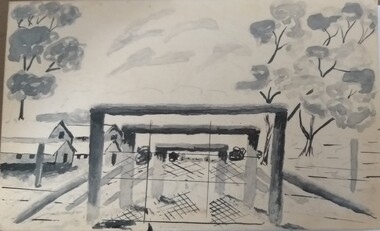
Photograph - Photographs, Camp 13 entrance gates
Sketch of the entrance gates of Camp 13 Murchison.Black and white photograph of a sketch of the entrance gates to Camp 13 Murchison, with huts to the left, behind the wire, a large tree behind the huts, and two trees on the right inside the yard. On coreflue.camp 13, murchison, camp entrances -
 Marysville & District Historical Society
Photograph (Item) - Black and white photograph, Camp Opposite The "Scandinavians', c1900
An early black and white photograph of a camp which was opposite The Scandinavian's Hotel and Boarding House along the Yarra Track.An early black and white photograph of a camp which was opposite The Scandinavian's Hotel and Boarding House along the Yarra Track. The Yarra Track is the former name of the gold fields road from Healesville to the Woods Point and Jordan Goldfields, in Victoria, Australia. A direct route via the Yarra River and the Great Divide was discovered by Rieck in September 1862 and became known as the Yarra Track. Early in 1863, the Victorian Government decided to construct a 193-kilometre (120 mile) road along the route. Its original width varied between 4 and 6 metres (12 and 20 feet), and was designed to accommodate horse-drawn vehicles. The Track involved the climbing of the Black Spur, descent into the Acheron Valley, and then through Marysville to the Cumberland where it followed the existing route.ARMSTRONG COLLECTION 42 STATION STREET/ SANDRINGHAM 3191/ TEL. (03) 9521 5442/ IAN M.L. ARMSTRONG OAMthe scandinavians', yarra track, healesville, wood's point, jordan goldfields, victoria, yarra river, great divide, reick, black spur, acheron valley, marysville, cumberland creek -
 Tatura Irrigation & Wartime Camps Museum
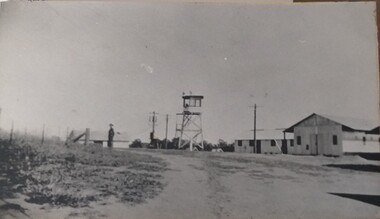
Photograph, Camp Buildings and sentry tower, 1939
Dhurringile camp view. General view of buildings, sentry tower and a lone guard.Black and white photograph of general view of huts, lookout tower, fence and lone soldier with road sweeping front right, swinging left. Taken at Dhurringile Mansion camp.dhurringile pow camp -
 Federation University Historical Collection
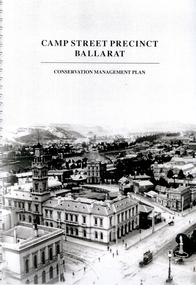
Book - Report, Camp Street Precinct Ballarat Conservation Management Plan, November 1999
This report was prepared for the City of Ballarat to assist in the process of planning for the future management and development of the Camp Street precinct.214 page report with spiral binding and a cover featuring a black and white image of the Ballarat Post Office, Ballarat Free Library and Ballarat State Offices. The report includes information on buildings in the Camp Street precinct including Art Gallery of Ballarat, old Colonists' Hall, former Police Court, former Police Station, Former Police Barracks, Government Camp (1852-1864), etcballarat fine art gallery, art gallery of ballarat, ballarat old colonists hall, ballarat former library, ballarat old court house, old ballarat police station, former ballarat post office, ballarat market reserve, ballarat benevolent reserve, bones building, old colonists hall, former ballarat call room, former ballarat police court, archaeology, aledandria tea room, former lister and angel warehouse, pratts warehouse, cms, conservation management plan, old colonists' hall, old colonists' association -
 Stawell Historical Society Inc
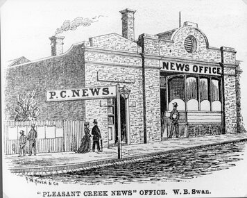
Drawing, Pleasant Creek News Office in Upper Main Street Stawell from the P.C. News Supplement 1888 -- Sketch
Pleasant Creek News Office upper Main Street from P.C. News Supplement 1888 Line drawing of news office"Pleasant Creek News" Office. W. B. Swan.stawell businesses -
 Ringwood and District Historical Society
Photograph, Mullum Mullum Creek from footbridge on Munro St., Ringwood, looking east - 1969, 1970
Typed below photograph, "Mullum Creek from footbridge on Munro St. Looking east, 1969". Written on backing sheet, "Mullum Creek looking east at footbridge at Munro St. 1970. Pampas grass was planted years ago by Mrs. Blood".(To be verified in regards to planter). +Additional Keywords: Brown, Mrs / Blood, MrsTyped below photograph, "Mullum Creek from footbridge on Munro St. Looking east, 1969". Written on backing sheet, "Mullum Creek looking east at footbridge at Munro St. 1970. Pampas grass was planted years ago by Mrs. Brown or Mrs Blood". -
Tatura Irrigation & Wartime Camps Museum
Audio Tape, Camp Construction and local history, 1993
Side A: Interview with Bill Ranson, construction of Camp 1 etc. 8 July 1993 - local history and irrigation. Side B: Interview with Charlie Hogan local history (Bill Martin) 14 July 1993Audio tape Akai SX90Bill Ranson - camp construction Charlie Hogan - local history - Bill Martinbill ranson, camp 1 construction, charlie hogan, bill martin -
Whitehorse Historical Society Inc.
Letter - Correspondence, WW2 army camp, Esdale Road, Nunawading, n.d
Note from Beryl Gray on an interview with Mr Mion of Haines St., Mitcham. Who stated that there was an army camp in Esdale Road, Nunawading during World War 2.Note from Beryl Gray on an interview with Mr Mion of Haines St., Mitcham who stated that there was an army camp in Esdale Road, Nunawading during World War 2.Note from Beryl Gray on an interview with Mr Mion of Haines St., Mitcham. Who stated that there was an army camp in Esdale Road, Nunawading during World War 2.mion, (mr), world war 1939-1945, esdale street, nunawading -
 Eltham District Historical Society Inc
Photograph - Negative, Lewis Tulk, 1st Eltham Scout Hall, Youth Road, Eltham, c.1980
Taken during Yarra Batman Area Scout Stage III training at Eltham. Eltham was part of the YBA. Donated by Lewis Tulk, former Scout Area Training Commisioner for Leaders.scouts victoria, scout leader training, lewis tulk collection, 1st eltham scouts, eltham, yarra batman area, youth road -
 Hymettus Cottage & Garden Ballarat
scarf, Scout Scarf
Scouting scarf blue with , belonging to Glen Taffe 3rd Wendouree Scouts 1980s from attending the fourteenth Australian Jamboree at Cataract Park New South Wales 1985-86.scouting movement, glen taffe, jamboree, cataract park, new south wales, 3rd wendouree scouts, ballarat. -
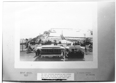 St Kilda Historical Society
Photograph, Wall Bros, Foreshore Reclamation work, c. 1905
Between pier and St Kilda Yacht Club, taken from Esplanade Hotel, c1905black and white photograph, unmounted copy, fair conditionThe first foreshore reclamation work between the pier and the royal St Kilda Yacht Club, taken from the Esplanade Hotel about 1905. Wall Bros., 15 Chapel St, St Kilda. D.J. Taggart 58 Glenhuntly Road, Elwood 3184. -
 Eltham District Historical Society Inc
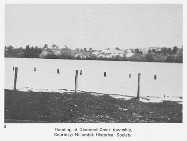
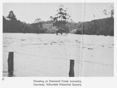
Work on paper (Sub-Item) - Photograph, Flooding at Diamond Creek Township
Black and white photograph of the Diamond Creek in flood at Diamond Creek township in 1934. In 1934 extensive flooding of the Yarra River and Diamond Creek set new records for flood plain level (Eltham Chronology EDHS) Nillumbik Historical Society collectionflood, diamond creek, flooding, nillumbik historical society -
 Eltham District Historical Society Inc
Work on paper (Sub-Item) - Photograph, Flooding at Diamond Creek Township
Black and white photograph of the Diamond Creek in flood at Diamond Creek township in 1934. In 1934 extensive flooding of the Yarra River and Diamond Creek set new records for flood plain level (Eltham Chronology EDHS) Nillumbik Historical Society collectionflood, diamond creek, flooding, nillumbik historical society -
 Stawell Historical Society Inc
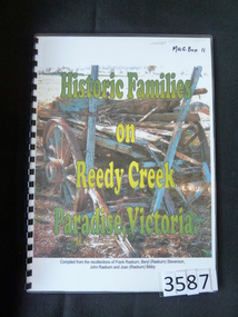
Book, Stephen & Sheryl Pickering, Historic Families on Reedy Creek Paradise Victoria, 2007
Family History. THe history of families on Reedy CReek Compiled from the recollections of Frank Raeburn, Beryl (Raeburn) Steveson, John Raeburn and Joan (Raeburn) Bibby.Laminated cover & black spiral binding. Title on cover with dilapidated wagon as background. writing in Yellow & GreenHistoric Families on Reedy Creek Paradise, Victoriastawell -
 Kew Historical Society Inc
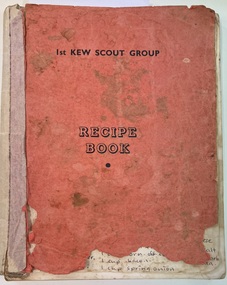
Booklet, 1st Kew Scout Group : Recipe Book, 1975
Paperback with red cover inscribed with the title. Inside a preface including acknowledgements by the President of the Auxiliary. Printed recipes with some annotations by the owner. Text typed onto stencils then printed and assembled by members of the Auxiliary. The 1st Kew Scouts was one of the first Scout Troops in Victoria, being formed in 1909. From 1927 they met in a Scout Hall in Disraeli Street, Kew until it was demolished in 1993. Still operating from their new Scout Hall on the corner of Kilby Road and Kellett Grove, Kew.Small, self-published, paperback recipe book published by the Ladies' Auxiliary of the 1st Kew Scout Group. The book of recipes was compiled in 1967 from a selection of favourite recipes submitted by the Ladies' Auxiliary and their friends. A preface, written by the President of the Auxiliary, Margaret Jones, acknowledges the role of Miss Bet. De Hays who typed the stencils as well as assisting in the booklet's preparation. The purpose of the book was to raise funds for equipment to be used by members of the 1st Kew Scout Group.non-fictionPaperback with red cover inscribed with the title. Inside a preface including acknowledgements by the President of the Auxiliary. Printed recipes with some annotations by the owner. Text typed onto stencils then printed and assembled by members of the Auxiliary. The 1st Kew Scouts was one of the first Scout Troops in Victoria, being formed in 1909. From 1927 they met in a Scout Hall in Disraeli Street, Kew until it was demolished in 1993. Still operating from their new Scout Hall on the corner of Kilby Road and Kellett Grove, Kew.recipe books, 1st kew scout group, booklets -
![View of Sailor’s Creek Bridge / [by] Nicholas Caire, circa 1876](/media/collectors/550653872162f11fb04854aa/items/577b5b7ed0cdd10948d14ae1/item-media/577b5be9d0cdd10948d196a2/item-fit-380x285.jpg) Kew Historical Society Inc
Kew Historical Society IncPhotograph, Anglo-Australasian Photographic Company, View of Sailor’s Creek Bridge, c.1876
Nicholas Caire was born on Guernsey in the Channel Islands in 1837. He arrived in Adelaide with his parents in about 1860. In 1867, following photographic journeys in Gippsland, he opened a studio in Adelaide. From 1870 to 1876 he lived and worked in Talbot in Central Victoria. In 1876 he purchased T. F. Chuck's studios in the Royal Arcade Melbourne. In 1885, following the introduction of dry plate photography, he began a series of landscape series, which were commercially successful. As a photographer, he travelled extensively through Victoria, photographing places few of his contemporaries had previously seen. He died in 1918. Reference: Jack Cato, 'Caire, Nicholas John (1837–1918)', Australian Dictionary of Biography.An original, rare photograph from the series 'Views of Victoria: General Series' by the photographer, Nicholas Caire (1837-1918). The series of 60 photographs that comprise the series was issued c. 1876 and reinforced a neo-Romantic view of the Australian landscape to which a growing nationalist movement would respond. Nicholas Caire was active as a photographer in Australia from 1858 until his death in 1918. His vision of the Australian bush and pioneer life had a counterpart in the works of Henry Lawson and other nationalist poets, authors and painters.Views of Victoria (General Series) No.31 / ‘View of Sailor’s Creek Bridge’ / Albumen silver photograph mounted on boardOn Reverse" ‘Sailor’s Creek as situated in the Jim Crow Ranges, which Range forms a portion of the Great Dividing Range of Mountains in Victoria. These hills contain many romantic spots. The one which forms the subject of the present illustration is a view of the Bridge which spans the Creek. Gold has been found throughout the course of the bed of this Creek in payable quantities. The diggers, as may be seen in the photograph, have constructed sluices in the side of the embankment for the purpose of washing the fine gold contained in the wash-dirt.’nicholas caire (1837-1918), sailor's creek (vic), gold mining (vic) -
![View of Sailor’s Creek Falls / [by] Nicholas Caire, circa 1876](/media/collectors/550653872162f11fb04854aa/items/577b5d13d0cdd10948d24e07/item-media/577b5d7dd0cdd10948d282ff/item-fit-380x285.jpg) Kew Historical Society Inc
Kew Historical Society IncPhotograph, Anglo-Australasian Photographic Company, View of Sailor’s Creek Falls, c. 1876
Nicholas Caire was born on Guernsey in the Channel Islands in 1837. He arrived in Adelaide with his parents in about 1860. In 1867, following photographic journeys in Gippsland, he opened a studio in Adelaide. From 1870 to 1876 he lived and worked in Talbot in Central Victoria. In 1876 he purchased T. F. Chuck's studios in the Royal Arcade Melbourne. In 1885, following the introduction of dry plate photography, he began a series of landscape series, which were commercially successful. As a photographer, he travelled extensively through Victoria, photographing places few of his contemporaries had previously seen. He died in 1918. Reference: Jack Cato, 'Caire, Nicholas John (1837–1918)', Australian Dictionary of Biography.An original, rare photograph from the series 'Views of Victoria: General Series' by the photographer, Nicholas Caire (1837-1918). The series of 60 photographs that comprise the series was issued c. 1876 and reinforced a neo-Romantic view of the Australian landscape to which a growing nationalist movement would respond. Nicholas Caire was active as a photographer in Australia from 1858 until his death in 1918. His vision of the Australian bush and pioneer life had a counterpart in the works of Henry Lawson and other nationalist poets, authors and painters.Views of Victoria (General Series) No.32 / 'View of Sailor’s Creek Falls’ / Albumen silver photograph mounted on boardOn Reverse: ‘The Sailor’s Creek Falls are situated near Daylesford, in one of the valleys of the Jim Crow Ranges. The Creek at this particular juncture is naturally adapted for the formation of a large reservoir. The stream of water is small during summer months, but a great body of water may sometimes be seen during the winter or wet seasons.’nicholas caire (1837-1918), sailor's creek (vic), jim crow ranges, daylesford, sailor's falls, photography - landscapes - victoria -
 Falls Creek Historical Society
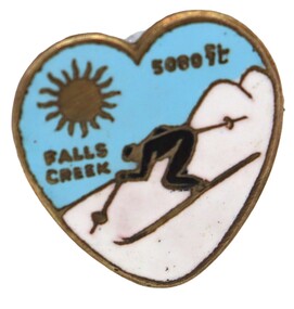
Badge - Falls Creek 5080 ft, c1953
This item is from the private collection of George Shirling of Red Onion, Falls Creek. It is an early souvenir from Falls Creek. George Shirling arrived in Falls Creek in 1962. He engaged Phil Nowell to build the original Koki Alpine Lodge which opened in 1965 with 14 beds. George operated the lodge with Michael “Baldy” Blackwell as manager. He also graduated in sport psychology in 1981 and was invited to become team psychologist for the Australian Winter Olympic team which went to Albertville, France, in 1992. He later owned the Red Onion Chalet. George credited the success of Koki to “Baldy” Blackwell. “Baldy” and Phil Nowell started the Trackers Mountain Lodge in partnership during the 1980s. In 1971 George sold Koki Lodge to Sigi Doerr. In 2024 the renamed Koki Alpine resort remains a highly popular destination in Falls Creek. George Shirling passed away on 27th February 2023. He had remained actively involved in Falls Creek and was generous with his time and knowledge, always an amazing supporter of The Falls Creek Museum and Falls Creek Village.This item is significant because it is a rare souvenir from Falls Creek, Victoria in the 1950s.A small enamelled badge depicting a skier descending the slopes. The badge is blue, white and black with gold trim. It has an accompanying typed sign.In top section of badge: FALLS CREEK 5080 ft On Sign: ITEM NO. 105 Very rare badge - "Falls Creek 5000" c1952 Donated by "Diana" of Diana Lodgegeorge shirling, nissen lodge -
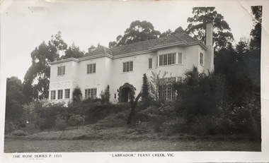 Kew Historical Society Inc
Postcard, Rose Stereograph Company, "Labrador," Ferny Creek, Vic, 1920-1939
The Kew Historical Society's postcard collection includes views of Kew, Melbourne and Greater Melbourne as well as those including overseas scenes sent or received from Europe or the Middle East. They date from the 1890s to the 2000s. These postcards may or may not include the name of the publisher or printer. A number of the cards were published as parts of popular series. A way of dating early postcards is to identify whether the reverse was divided by a central line which became the norm after 1902 in the United Kingdom. However, other postcards produced after this date do not always conform to this print layout.A Rose Series postcard of "Labrador" in Ferny Creek in the Dandenongs to the north of Melbourne. The postcard is numbered P. 1511.Front: THE ROSE SERIES P. 1511 COPYRIGHT / "LABRADOR' FERNY CREEK, VIC / THE ROSE SERIES DELUXE / A REAL PHOTOGRAPH PRODUCED IN AUSTRALIAferny creek - victoria, labrador - ferny creek, postcards, guest houses -- ferny creek (vic.), labrador -- ferny creek (vic.) -
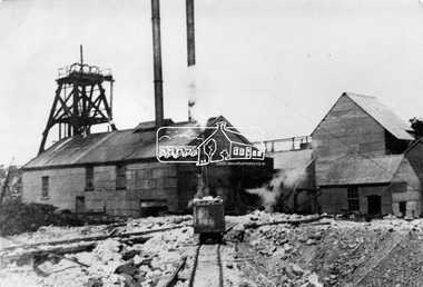 Eltham District Historical Society Inc
Photograph, Diamond Creek Gold Mine
Situated at the end of Fraser Street, Diamond Creek. The Diamond Creek Gold Mine was the largest in the Diamond Valley Shire with a shaft depth of over 290 metres at the peak of its development in 1915. The surface plant was quite large with four boilers and five steam engines working the battery, winder, water pump, air compressor and lighting generator.This photo forms part of a collection of photographs gathered by the Shire of Eltham for their centenary project book, "Pioneers and Painters: 100 years of the Shire of Eltham" by Alan Marshall (1971). The collection of over 500 images is held in partnership between Eltham District Historical Society and Yarra Plenty Regional Library (Eltham Library) and is now formally known as 'The Shire of Eltham Pioneers Photograph Collection.' It is significant in being the first community sourced collection representing the places and people of the Shire's first one hundred years.Digital imagesepp, shire of eltham pioneers photograph collection, diamond creek, goldmine, gold mine, poppet head -
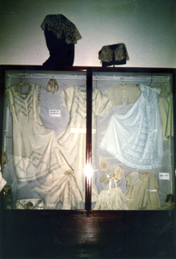
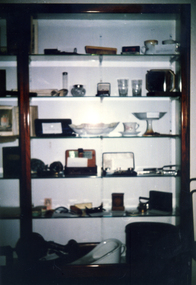 Whitehorse Historical Society Inc.
Photograph, North Wall Display in Museum
Coloured photo of North Wall Display in Museummuseum -
 Whitehorse Historical Society Inc.
Photograph, North Wall Display in Museum
Coloured photo of North Wall Display in Museummuseum -
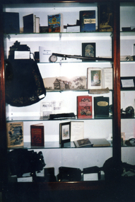
 Whitehorse Historical Society Inc.
Photograph, North Wall Case in Museum
Coloured photo of North Wall Case in Museummuseum, display -
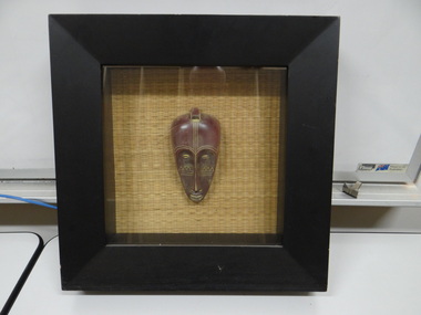 Brimbank City Council
African Mask, Wood Wall Art with Matt and Poly Mask
Wood Wall Art with Matt and Poly Mask -
Charlton RSL Sub Branch
Souvenir - Checkpoint Charlie souvenier, Small piece from the Berlin wall in capsule on card
Card with small piece of Berlin wall in capsule.Checkpoint Charlie Berlin. You are leaving the American sector -
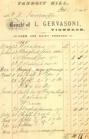 Ballarat Heritage Services
Document - Image, Invoice from Luigi Gervasoni, Vigneron, of Yandoit Creek, 1888, 24/10/1886
Luigi Gervasoni and Ambrogio Invernizzi were partners at Yandoit Creek in the 1860s.Invoice from Luigi Gervasoni, Vigneron, of Yandoit Creek, 1888luigi gervasoni, philately, invoice, yandoit, ambrogio invernizzi, vigneron, yandoit creek, farm produce, dairy produce, farm, agriculture -
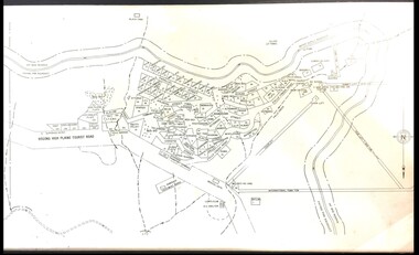 Falls Creek Historical Society
Map - Falls Creek mid 1970s
A site map produced for the Falls Creek Tourist Area Management CommitteeThis map is significant because it documents an important stage in the development of Falls Creek, Victoria.A framed and mounted site map of Falls Creek mid 1970sfalls creek tourist area management committee, falls creek tourist area, falls creek 1970s -
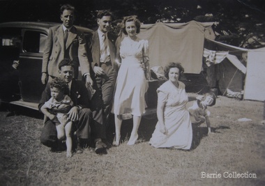 Melton City Libraries
Photograph, Edna and Bon's family camp trip at Apollo Bay, 1948
Wendy Barrie's memories of Apollo Bay The camping trips were a yearly event after the harvest had finished. The trip down to the beach was a much-anticipated event heading out through Parwan and to Geelong leaving behind the hot and dusty plains and our parents relieved to have the hard work of harvesting left behind. The Otways in the distance were reached with great anticipation, Mum in the car and Dad in the Truck ahead of us anxiously winding through the narrow roads and negotiating the hairpin bends and breathing in the cool fresh air of the forest, and keeping an eye out of the log trucks that might come sweeping the corner. The tree ferns with their dripping moisture and the giant trees and the unmistakeable small of the eucalypts. Great excitement was when we caught our first view of the sea from the highest point of the road and then is was the cautious drive the sea level to the sight of the blue ocean with the white of the waves crashing on the rocks and the pristine sand. The water from the Wild Dog and Skenes creek trickling onto the ocean. The tree ferns with their dripping moisture and the giant trees and the unmistakeable smell of the eucalypts. The return journey was usually taken on the Great Ocean Road, it was considered safer to be on the inside of the road. In the early days it was very narrow and passing oncoming cars was taken very cautiously. Landslides and floods sometimes meant we would take the inland route. One year the bridges were washed away and bailey bridges were erected to keep the road open. Rock falls off the cliffs were common Stops on the way home gave us our last chance for our feet in the sand and a swim in the ocean. By the time we reached the hill at Angle Sea the vast blue ocean was behind us and we trekked back through Geelong- Bacchus road and the plains of stubble and the dry grass, and sometimes evidence of burnt patches from a bush fire. The closest we came to a pool at home was the concrete sheep trough at the gate to the work sheds. It was filled with bore water pumped from the nearby windmill. Edna, Bon and their family members at their camp site in Apollo Baylocal identities