Showing 651 items matching "station reserve"
-
 Ballarat Tramway Museum
Slide - 35mm slide/s, early 1960's
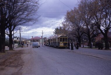
Bendigo Charing Cross, looking east towards railway station, with SEC No. 7 about to depart for Eaglehawk. A Birney tram in background heading for Quarry Hill. Photo shows 'Ezywalkin' and 'Fountain Plaza' buildings, has large white with black lettering road signs on left. On centre pole in front of tram is smaller road direction signs (yellow with black letters) for Echuca, Heathcote and Melbourne. Tram has dash canopy lights, early 1960's.niltramways, trams, bendigo, charing cross, quarry hill, eaglehawk, tram 7 -
 Ballarat Tramway Museum
Slide - 35mm slide/s, Keith Kings, 20/10/1962 12:00:00 AM
Bendigo trams, 18, 26, 29, 11 in Bridge St. Loop, with 5 in Nolan St waiting for a Bendigo tram? on 20-10-1962 as part of an ARHS tour to Bendigo. Note white convoy marker on front tram, Tram 18 showing 'RLY Station' destination. Tram 18 has 'Kohn Drinks' ad on front panel. Photo by Keith Kings.Stamped 'K.S.KIngs etc', and in blue ink 'K(k)(384), 1/250, f5.6, 20/10/62, ARHS, Convoy 'A' 5,11,29,26,18 on Bridge St.. Loop, Bendigo'tramways, trams, bendigo, north bendigo, bridge st loop, arhs, tram 18, tram 26, tram 29, tram 11, tram 5 -
 Kew Historical Society Inc
Plan, Melbourne & Metropolitan Board of Works : Contour Plan of Melbourne & Suburbs : Melbourne Sewage, 1894
The Melbourne and Metropolitan Board of Works (MMBW) plans were produced from the 1890s to the 1950s. They were crucial to the design and development of Melbourne's sewerage and drainage system. This plan forms part of a large group of MMBW plans and maps that was donated to the Society by the Mr Poulter, City Engineer of the City of Kew in 1989. Within this collection, thirty-five hand-coloured plans, backed with linen, are of statewide significance as they include annotations that provide details of construction materials used in buildings in the first decade of the 20th century as well as additional information about land ownership and usage. The copies in the Public Record Office Victoria and the State Library of Victoria are monochrome versions which do not denote building materials so that the maps in this collection are invaluable and unique tools for researchers and heritage consultants. A number of the plans are not held in the collection of the State Library of Victoria so they have the additional attribute of rarity.Digital copy of an original MMBW plan. This contour plan shows the area identified by the MMBW for purposes of drainage and sewerage in 1894. The suburbs represented extend from Williamstown in the west to Bulleen in the east, and from Preston in the north, south to Sandringham. Suburbs are outlined in coloured ink. Red lines indicate main and branch sewers in existence at the beginning of 1894 in central and inner Melbourne. These extended as far as Williamstown and Brighton, but not yet as far as Kew, where sewering did not commence until 1901. Contour lines show the topography, which was important for indicating the fall of the land for the laying of sewers and drainage channels. Kew appears to be fairly undeveloped at this date except for railway lines and stations (the Kew and Outer Circle lines), main roads, the Kew Lunatic Asylum Reserve and Studley Park. However, the contour plan does not accurately represent the density of settlement, nor the large number of houses, which were being built in Kew and other suburbs from the 1850s to the land boom of the late 1880’s and early 1890’s. This plan is part of a large and historically significant group of MMBW plans and maps that was donated to the Society by the Mr Poulter, City Engineer of the City of Kew in 1989.mmbw contour plan of melbourne and suburbs, melbourne and metropolitan board of works, melbourne sewage, cartography -
 Kew Historical Society Inc
Album - Scrapbook, Eva Grant, Historic Buildings, Kew, 1958-78, 1970s
One of three scrapbooks of photographs and newspaper cuttings taken and or collected by Eva Grant, a past member of the Kew Historical Society, which were donated by her niece, Julie Thomson. The albums include many photographs of Kew from the 1950s to the 1970s. Buildings included in the scrapbook include: Billy Hughes' house - 167 Cotham Road Congregational Church - Walpole Street (c.1978) Country Roads Board - Denmark Street (1960) Dorothy Rogers Reserve - Studley Park Road Ellsmere (also Ellesmere/Ellsmore) - Princess Street Field Place - 3 Henty Court Fernhurst - 13 Fernhurst Grove Kew Civic Centre (1959) Kew Junction (1958) Kew Railway Station (1902, 1959) Kew Recreation Hall - Wellington Street (1960) Neama (Hall) - Studley Park Road Southesk (formerly Ordsall) - Cotham Road (c.1960) St Anthony's Home for Babies (formerly Madford) - 43 Wellington Street (c.1976) Studley House - Nolan AvenueThe scrapbook contains historically significant, rare and sometimes unique images of significant heritage buildings in Kew, including their erection and demolition. 11-page scrapbook of photographs and newspaper clippings with annotations by Eva Grant, a past member of the Kew Historical Society. The pages of the album can be viewed in the image carousel above. Based on the text and known dates of demolition of a number of the buildings, the scrapbook was assembled over a twenty year period between c.1958-c.1978.Includes letter from donoreva grant, billy hughes' house - 167 cotham road, congregational church - walpole street - kew, country roads board - denmark street - kew, dorothy rogers reserve - studley park road - kew, field place - 3 henty court - kew (vic), ellsmere (also ellesmere/ellsmore) - princess street - kew, fernhurst - 13 fernhurst grove - kew (vic), kew civic centre - civic drive - kew (vic), kew junction - kew (vic), kew railway station - denmark street - kew (vic), recreation hall - wellington street - kew, neama - hall - studley park road - kew (vic), southesk - ordsall - cotham road- kew (vic), st anthony's home for babies - madford - 43 wellington street (vic), studley house - nolan avenue - kew (vic) -
 Kew Historical Society Inc
Plan, J R Mathers & McMillan, 5 Splendid vVlla Allotments,: Segtoune St. & Windsor St., Kew, 1928
Prue Sanderson, in her groundbreaking ‘City of Kew Urban Conservation Study : Volume 2 - Development History’ (1988), summarised the periods of urban development and subdivisions of land in Kew. The periods that she identified included 1845-1880, 1880-1893, 1893-1921, 1921-1933, 1933-1943, and Post-War Development. These periods were selected as they represented periods of rapid growth or decline in urban development. An obvious starting point for Sanderson’s groupings involved population growth and the associated economic cycles. These cycles also highlighted urban expansion onto land that was predominantly rural, although in other cases it represented the decline and breakup of large estates. A number of the plans in the Kew Historical Society’s collection can also be found in other collections, such as those of the State Library of Victoria and the Boroondara Library Service. A number are however unique to the collection.Subdivision plans are historically important documents used as evidence of the growth of suburbs in Australia. They frequently provide information about when the land was sold on which a built structure was subsequently constructed as well as evidence relating to surveyors and real estate and financial agents. The numerous subdivision plans in the Kew Historical Society's collection represent working documents, ranging from the initial sketches made in planning a subdivision to printed plans on which auctioneers or agents listed the prices for which individual lots were sold. In a number of cases, the reverse of a subdivision plan in the collection includes a photograph of a house that was also for sale by the agent. These photographs provide significant heritage information relating house design and decoration, fencing and household gardens.In 1928, five residential allotments bordering Segtoune and Windsor Streets were advertised for sale as part of a subdivision. Four of the blocks faced Segtoune Avenue. The auctioneers proclaimed the advantages of the sites: ‘Situate one minute from the High Street Electric Tram, which now runs direct to Spencer Street via Bridge Road and Flinders Street. Opposite the East Kew Railway Station (Outer Circle Line), which may be reopened In connection with the new Line from Kew to Doncaster; Adjacent lo the Kew Recreation Reserve, Sports Oval, and Swimming Bath; Half Minute from the Shopping Centre of East Kew, Accessible to the State School and Other Educational Centres’. The Harp of Erin Hotel and the route of the Outer Circle Railway line are marked on the plan. The Recreation Reserve and Sport Oval refer to Victoria Park. The Swimming Baths were located on the site of the current Kew Recreation Centre.subdivision plans - kew, segtoune street -- kew (vic.), windsor street -- kew (vic.) -
 Kew Historical Society Inc
Photograph - Kew Junction, Herald & Weekly Times, 1962
This is an aerial oblique image looking north. It shows Kew Junction before construction of VicRoads (Country Roads Board), Murphy's (Leo's) supermarket, and office towers. It also shows a building on the land now known as the Raoul Wallenberg Reserve, the Kew Municipal Offices in Walpole Street, and St Paul's School for the Blind in Fernhurst Grove, and Kew Bowling Club in Wellington Street.An aerial photograph of Kew Junction, showing the intersection of High Street South, Studley Park Road, Princess Street, High Street and Denmark Street. A number of buildings, now demolished can be identified in the photo, including Jellis’ Bakeries on the corner of Princess Street and Studley Park Road." Annotation on reverse: "Kew Historical Society from Mr L. H. Chinner".kew junction, aerial photograph (kew), oblique aerial, st paul's school for the blind, kew municipal offices, high street kew, studley park road, kew war memorial, kew post office, kew police station, kew court house, high street south, kew, wellington street kew, denmark street kew -
 Kew Historical Society Inc
Photograph - High Street, Kew, 1960-65
The borders of the main components of Kew and Kew East have not always conformed to current boundaries. In the past this photograph has been labelled as East Kew, whereas for most of the twentieth century the site has been within Kew's borders. The purpose of the photograph is unrecorded yet it has value in that it shows those businesses who occupied this site in Kew during the early 1960s.This small photograph is significant as it shows the location of and building used by WD Vaughan, former Mayor of Kew who was a successful newspaper proprietor in Melbourne.Small polaroid colour positive of High Street in Kew, probably in the 1960s. From left we can see the brick viaduct covering the tracks of what was once the Outer Circle Railway. Behind this brick wall, Dunnings Timber Yard was situated. At the end of the walls of the viaduct there is an entrance to a walkway [now the Anniversary Trail], which once provided access to Windsor Avenue, and also to the East Kew Station (now demolished and part of the Outer Circle Railway Reserve). On the other side of this walkway is a cream brick building (demolished) occupied at this time by WD Vaughan Pty Ltd, printer and publisher of the Kew Advertiser (newspaper). Stretching behind the brick facade is an extensive building that must have housed the printing works. Beside Vaughan's, there is a large building (demolished) housing at that time an estate agent named AJ Kennedy. This area is now separated by kerbing.High St East Kew / Corner of Harp Rd. / Looking South -
 Kew Historical Society Inc
Photograph - Denmark Street, Kew, 1972
The Engineer's Department of the former City of Kew had an extensive collection of photograph of sites in Kew requiring documentation to inform public works. It also kept images of engineering practice in other parts of Melbourne, and overseas, that could be used as models for local activity. Many of these photographs (and plans) were donated to our collection in the 1980s. A number of the photographs are annotated, either on the image itself or on the reverse.This photograph, and others sourced from the City Engineer's Department of the former City of Kew, qualifies as an important record of local streets, public works, street beautification, and engineering techniques of the period. Original black and white photographic positive of automobiles and buildings in Denmark Street, Kew, immediately before the road enters Kew Junction. On the left is McKeon Motors and a retailer of Insulwool, while in the distance is the pharmacy on the corner of High Street and Princess Street (later demolished during the widening of Kew Junction). Notable are the bluestone guttering and what appears to be vacant land on the apex of the triangle of land bounded by High Street South, Denmark Street and Barkers Road. This site was the original location of O'Shaughnessy's 'Kew Hotel', and after the destruction by fire of the latter, the location of a service station. [It is now the site of the Cresco Reserve].Annotation verso: "Indicating the existence of a vehicular entrance at Denmark St abuttal of No.188 High St prior to reconstruction of channeling &c 1972."denmark street -- kew (vic.), kew junction, luestone gutters, mckeon motors, insulwool -
 Sunbury Family History and Heritage Society Inc.
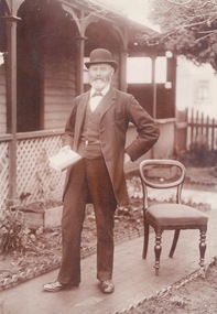
Photograph, c1900s
The man photograph in a garden is Joseph David Starkie, who was a Bulla Shire councillor for more than twenty years and during that time he was elected Shire President four times. He was also a member of the Sunbury Waterworks Trust and served as the chairman from 1905 - 1908. While serving on the water board he was instrumental in Sunbury gaining a permanent water supply. A drinking fountain has been erected on a reserve at the Village Green to honour the arrival of the permanent water supply to the town. The installation of a permanent water supply benefitted the town and contributed to a more reliable rail service as steam trains refilled their tanks with water at Sunbury Station. Prior to this the water was transported by horse and cart from nearby Jacksons Creek.A sepia photograph of a well-dressed man who is holding a book and is standing in a front garden of a weatherboard house.starkie, joseph daniel. -
 Beechworth Honey Archive
Map- Everton
Map of rural properties bounding penal reserve on western side of Beechworth between Spring Creek and Sheep Station Creek.Beechworth Sheet 3. Properties of J.Warner and N.Griffin shaded blue.map, everton, warner, griffin, beechworth honey -
 Surrey Hills Historical Society Collection
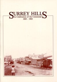
Book, Surrey Hills: in celebration of the centennial 1883-1983, 1983
A pictorial history of Surrey Hills based on information collected and based at the Surrey Hills Neighbourhood Centre. It includes early rural properties and diaries, the coming of the railway, land sub-division and early homes, schools, parks and recreation.A pictorial history of Surrey Hills based on information collected and based at the Surrey Hills Neighbourhood Centre. It includes early rural properties and diaries, the coming of the railway, land sub-division and early homes, schools, parks and recreation.surrey hills, railways, land use, migrants, spanish communities, transport, houses, wattle park, festivals and celebrations, churches, education, water supply, fire stations, hospitals, (mr) george klepper, ainger family, (mr) john woodhead, (mr) h. breedon, medical services, real estate agents, businesses, musical events and activities, entertainment, parks and reserves, scouts, guides -
 Surrey Hills Historical Society Collection
Book, Surrey Hills: in celebration of the centennial 1883-1983, Reprinted November 1992
A pictorial history of Surrey Hills and Mont Albert based on information collected by the history group at the Surrey Hills Neighbourhood Centre. It includes information about early rural properties and dairies, the coming of the railway, land sub-division and early homes, doctors, schools, churches, parks and recreation facilities.A pictorial history of Surrey Hills based on information collected and based at the Surrey Hills Neighbourhood Centre. It includes early rural properties and diaries, the coming of the railway, land sub-division and early homes, schools, parks and recreation.1992surrey hills, railways, land use, migrants, spanish communities, transport, houses, wattle park, festivals and celebrations, churches, education, water supply, fire stations, hospitals, (mr) george klepper, ainger family, (mr) john woodhead, (mr) h. breedon, medical services, real estate agents, businesses, musical events and activities, entertainment, parks and reserves, scouts, guides -
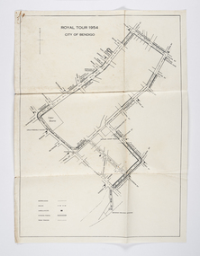 City of Greater Bendigo - Civic Collection
Document - Set of correspondence re Queen Elizabeth tour of Bendigo, Mrs T. R. Mannix, February 8th, 1954
Correspondence between Mrs T. R. Mannix, Swan Hill Wolf Cub Pack master to District Scout Commissioner Mr J. I. Samson for an invitation to be included with the local scout groups in functions to welcome Queen Elizabeth and the Duke of Edinburgh to Bendigo on Friday, the 5th of March 1954. The response from the Commissioner included typed plans of the event and maps of the royal tour through the streets of Bendigo starting and finishing at the train station.Set of correspondence including typed gatefold letter, typed plans for placement of visitors and role of the military and maps of CBD Bendigo and of Upper Reserve.queen elizabeth, duke of edinburgh, boy scout association, mayor clayton, city of greater bendigo royal visits, city of greater bendigo community groups, city of greater bendigo tourism -
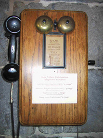 Parks Victoria - Cape Nelson Lightstation
Functional object - Telephones
Each of the five telephones is attached to a timber, wall‐mounted box. They are original to the precinct buildings and date from the early twentieth century. Located in the lighthouse lantern room, the former head keeper’s quarters, the former assistants’ quarters, and the buildings known today as the generator shed and the café, they formed an intercom system that facilitated communication between the lightstation buildings.Wall‐mounted Bakelite telephones with crank handles can be found at all six light stations, however Gabo Island has the only other example of a timber‐mounted phone. Its design is slightly different for incorporating an inclined surface for jotting down notes. As fixtures, the telephones are considered to be part of the building fabric and included in the Victorian Heritage Register listing for the Cape Nelson Lightstation (H1773; 18 February 1999). They are historically significant for their historical and technical values as part of the early communications system used at the lightstation.Five similar intercom system telephones. All are wall mounted timber boxes with Bakelite black hand sets and black cords. The five phones each have two bells at the top of the box and a crank handle at the side. Three phones have brass bells, two have black metal bells. All phones have instructions on the front either in a frame or glued to the timber."C of A" and "PMG" Written instructions on how to use the phones are printed on paper fixed to the front of the telephones. "TO CALL ....../ TO ANSWER...../ WHEN FINISHED....." -
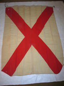 Parks Victoria - Cape Nelson Lightstation
Functional object - Flag set, navigational
The flags were used for communicating messages to passing ships. Knowledge of visual signaling was mandatory for all lightkeepers and all stations maintained a set of these flags. Although used for centuries, visual flag signaling formally developed in the nineteenth century and was published internationally as a system in 1857. By the early twentieth century it had developed into an effective means of conveying all kinds of short range visual messages.The Cape Nelson Lightstation is architecturally and scientifically (technologically) important as the most intact complex of lightstation buildings in Victoria. The octagonal signal station is a unique feature which is all the more important for its complete set of signal flags’. Cape Nelson Lightstation’s complete set of 41 alphabetic and numeric visual signaling flags (including substitute and answering pennants) are made of bunting, a coarse fabric of worsted (open yarn wool) in various colour combinations, and some of the fabric is hand sewn and bears inscriptions. Attachments include handmade wooden toggles, brass clips and hemp rope. -
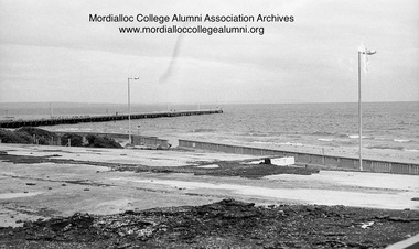
 Mordialloc College Alumni Association Inc (MCAA)
Photograph, 1981 - Peter Scullin Reserve Mordialloc Foreshore
Image digitised from negative -
 Mordialloc College Alumni Association Inc (MCAA)
Photograph, 1981 - Peter Scullin Reserve Mordialloc Foreshore, 1981
Image digitised from negative -
 Mordialloc College Alumni Association Inc (MCAA)
Photograph, 1981 - Peter Scullin Reserve, Mordialloc Foreshore
-
 Mordialloc College Alumni Association Inc (MCAA)
Photograph, 1981 - Peter Scullin Reserve Mordialloc Foreshore
-
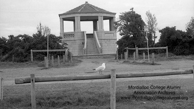 Mordialloc College Alumni Association Inc (MCAA)
Photograph, 1981 - Rotunda at Peter Scullin Reserve Mordialloc Foreshore
-
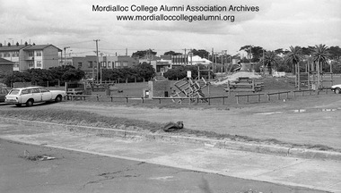
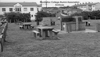
 Mordialloc College Alumni Association Inc (MCAA)
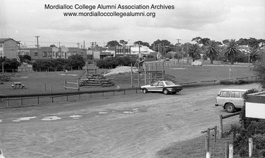
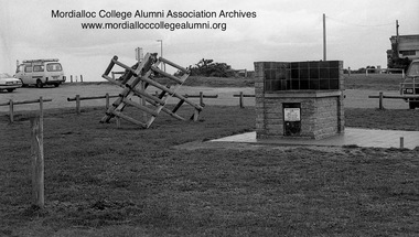
Photograph, 1981 - Peter Scullin Reserve Mordialloc Foreshore - playground and barbecue
The precinct has undergone significant change and beautification since 1981.mordialloc foreshore, mordialloc beach -
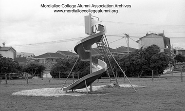
 Mordialloc College Alumni Association Inc (MCAA)
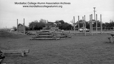
Photograph, 1981 - Peter Scullin Reserve Mordialloc Foreshore playground, 1981
Image digitised from negative -
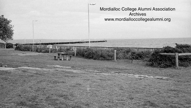
 Mordialloc College Alumni Association Inc (MCAA)
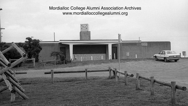
Photograph, 1981 - Peter Scullin Reserve Kiosk Mordialloc Foreshore, 1981
-
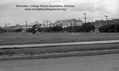
 Mordialloc College Alumni Association Inc (MCAA)
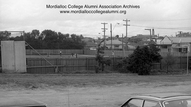
Photograph, 1981 Mordialloc Tennis Club at Peter Scullin Reserve precinct, 1981
Image digitised from negative. -
 Mordialloc College Alumni Association Inc (MCAA)
Photograph, 1981 - Peter Scullin Reserve Mordialloc - picnic area
-
 Mordialloc College Alumni Association Inc (MCAA)
Photograph, 1981 - Peter Scullin Reserve Mordialloc Foreshore
-
 Mordialloc College Alumni Association Inc (MCAA)
Photograph, 1981 - Peter Scullin Reserve Mordialloc Foreshore, 1981
-
Tarnagulla History Archive
Box of Murray Comrie's Research Notes (Set 2), Murray Comrie's Research Notes (Set 2), circa 1960s-80s
Murray Comrie Collection. Murray Comrie, born in Tarnagulla in 1912 also became a policeman and later a Chief Superintendent, retiring in 1972 and passing away in 1983 after a long illness. Murray Comrie's son Murray Jnr., to avoid confusion became known by his middle name, Neil. Neil Comrie also joined Victoria Police and rose through the ranks to become Chief Commissioner of Victoria Police from 1993 to 2001. Blue-grey archive box containing research notes of Murray Comrie. Contains: A series of 17 notepads in which Comrie has annotated historical information from local newspapers. A very long rolled up piece of paper on which is printed the Comrie family tree A yellow envelope containing photogrpahs which are low-quality and/or duplicates of other images in the Murray Comrie Collection. A ledger in which Comrie has listed every Police Station in Victoria and its establishment date. Four vinyl non-archival document binders in which Comrie's research notes and photographs were housed when donated. Material was transferred out of these for preservation reasons. The contents of this box were compiled or used by Murray Comrie during his research for a book about Tarnagulla. tarnagulla, comrie, research, banks, lodge, gold & mining, war/military, local people, buildings, businesses, local government, post offices, policing, recreation reserve, railway, clubs & societies, band/music, hotels, churches, schools, fire brigade, laanecoorie, names -
 Parks Victoria - Gabo Island Lightstation
Insulator
Modern communication technologyarrived on gabo Island with the construction of the telegraph line from Eden to Gabo Island in 1870. The insulator is associated with the telegraph station. Used at the H.F Radio Beacon. The items of telegraphic equipment comprise a number of ceramic and glass insulators of varying age and type. In addition to insulators, there is a telephone insulator bracket made of metal with wooden pins. It was once attached to the top of a steel pole and some of these remain in situ along the former telegraph line (0044). Telegraphic communication commenced at the Gabo Lightstation in 1870, just eight years after the lightstation opened. The line from Sydney reached Eden, NSW by 1868 and was then extended to Gabo with the costs shared equally by NSW and Victoria. It was initially carried on posts across the sea to the island but was changed to a line along the seabed after the posts were washed away. The first telegraph office was a timber building on east side of the assistants’ quarters. In 1887 a new concrete telegraph office was built which included quarters for the operator, with Victoria and NSW sharing the construction costs. The 1992 CMP identified remnants of the line from its various phases of operation,and these were seen in 2016. Other ceramic insulators in the collection are associated with lines supported on utility poles for the transmission of high voltage electricity. The various insulators have second level significance for their historic value and provenanceFour armed cross shaped insulator with two holes through diagonally opposite sections. It is ceramic with a clear glaze. -
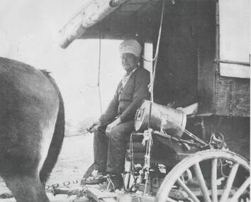 Wodonga & District Historical Society Inc
Photograph - Sikh Hawkers in Wodonga
Sikh hawkers were a regular sight throughout the Wodonga and Upper Murray district in the early 20th century. The regular visitors to the area included Pola Singh and Gambil (Gamble) Singh. Gamble Singh often camped on McKoy’s Moorefield property in West Wodonga and several other places around the district. Gamble was also a horse breeder and had several draught horses to pull his wagon. Like many of the hawkers he worked hard to send money back to support family in India. He apparently returned to India about 1950, but left some money in the Bank of NSW in Wodonga in case he returned. He allegedly died soon after and the money was eventually able to be claimed by his nephews in India. A small overlooked park in Wodonga is named the “Gamble Singh Park” in his memory. J. Flanagan who operated the Halfway Hotel commented on having as many as seven or eight bullock teams “yoked” overnight to the fence outside the hotel as well as 100 or more Indian hawkers – led by the fondly known Pola (Pollah) Singh. The hawkers returned to Wodonga annually to renew their hawkers’ license and camped on the flats, or also came to Wodonga to collect orders at the railway station to stock up their supplies. Pola Singh was often based at the Colac Colac reserve near Corryong and had on board his compatriot Isar Singh. He often acted as an intermediary between the individual hawkers and the authorities. Unfortunately, it was Pola’s habit to walk in front of his wagon at the start of each day. On the morning of 23 June 1923 his horses were restive and hard to control. They took flight and ran Pola down on the road near Cudgewa. He was rushed to the Corryong Hospital but died there a few days later, aged 65. Pola was cremated, with some of his ashes scattered in the Murray River and some returned to his homeland to be scattered in the Ganges River. His cremation was listed in the Obituary page of the Weekly Times, Melbourne on Saturday 14 July 1923. A small memorial to Pola Singh is located in the Corryong Cemetery.These images are significant because they help to document the history of the Sikh Hawkers who plied their services to Wodonga and throughout rural Australia in the late 19th and early 20th centuries.A collection of black and white images featuring Sikh Hawkers Gamble Singh and Pola Singh take in the Wodonga area.indian hawkers, sikh hawkers, gamble singh, pola singh