Showing 4075 items matching "survey"
-
 Bendigo Military Museum
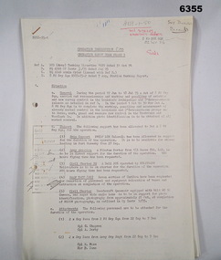
Administrative record - Royal Australian Survey Corps - Operation Sandy Bush Phase 3, Operation Instruction 8/75, 22 Sept 1975
Operation Instruction 8/75, Operation Sandy Bush Phase 3 was conducted in the period 1 Oct to 30 Nov 1975 by Det A, 8 Fd Svy Sqn. The Operation was to complete the marking, panelling measurement of already marked control in the Louisiade and D'Entrecasteaux groups and to Recce, Mark, Panel and Measure new survey control in the Trobriand and Woodlark Islands. In addition Photo Identification was to be obtained of all marked survey control. Panelling was the process of accurately laying out large sheets of white plastic to form a cross over the Survey Control Points (Points where the position is accurately known) so that they could then be photographed from the air. The positions of these crosses could then be accurately transferred from this new photography in stereo onto the aerial photography coverage used to produce mapping.Typed Instructions and diagrams without cover, 14 x A4 pages stapled in Top Left Hand Corner.Some annotations in top LH corner8 fd svy sqn, rasvy, royal australian survey corps, fortuna, army survey regiment, army svy regt -
 Bendigo Military Museum
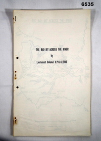
Journal - Royal Australian Survey Corps - The Bad Bit Across the River - LtCol HPG Clews 1934, LTCol HPG Clews RASvy, 1934
This Journal "The bad bit across the River" was written by - LtCol HPG Clews in 1934 and is about his experiences around the Colo River approximately 60 miles NW of Sydney, NSW. LtCol Clews was a remarkable man and his achievements were just as remarkable. He is affectionately known as "The Major." He served in the British Army 1909 - 1911 with the Sherwood Foresters. He then served in the Royal Australian Survey Corps from 1912 - 1949 and then served as the Senior Surveyor with the Snowy Mountains Authority from 1950-1958. A Survey Cairn is errected in Khancoban to record his life 1890 - 1980. This Journal records the field trip to establish Survey Control in very rugged country by a handful of party members on foot. The map shows the routes taken.14 x foolscap pages stapled and two hole punched. The Journal includes a map, 7 x pages of typed text and 4 x Annexesroyal australian survey corps, rasvy, fortuna, army survey regiment, army svy regt, asr, 2nd field survey company -
 Bacchus Marsh & District Historical Society
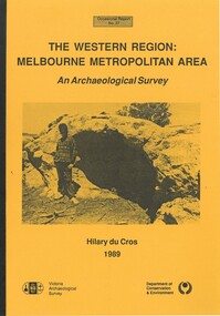
Book, The Western Region: Melbourne Metropolitan Area: An Archaeological Survey
This study aimed to locate and document Aboriginal archaeological sites in the western region of Melbourne. This area was defined by the study as extending out from the western suburbs of Melbourne to the Brisbane Ranges and north beyond Bacchus Marsh. The specific aim of the study was to investigate the Aboriginal archaeology of the Western Plains area in the vicinity west of Melbourne. The Bacchus Marsh, Melton and Werribee shire boundaries of the time defined the areas of the study. The study contains extensive lists of the types of artifacts found the the locations where they were found.Soft cover foolscap size book. 96 pages with b & w illustrations, images and maps (some folded). Part of Occasional reports series (Victoria Archaeological Survey) ; No. 27. Published by Department of Conservation and Environment, Melbourne, 1990. Author, Hilary Du Cros. BMDHS Loc. AR/SU5This study aimed to locate and document Aboriginal archaeological sites in the western region of Melbourne. This area was defined by the study as extending out from the western suburbs of Melbourne to the Brisbane Ranges and north beyond Bacchus Marsh. The specific aim of the study was to investigate the Aboriginal archaeology of the Western Plains area in the vicinity west of Melbourne. The Bacchus Marsh, Melton and Werribee shire boundaries of the time defined the areas of the study. The study contains extensive lists of the types of artifacts found the the locations where they were found. aboriginal australians victoria western plains, aboriginal artifacts, archaelogical sites victoria western plains, aboriginal artifacts bacchus marsh region -
 University of Melbourne, Burnley Campus Archives
Plan, Alton-Hascombe Feature Survey, c. 1990
1 tracing paper and 2 paper copies of plan by Department of Conservation, Forests and Lands, Division of Survey and Mapping, of adjoining gardens Alton and Hascombe at Mount Macedon, Victoria. Scale 1:1000. Plan of properties includes buildings, gardens and paddocks. 1 copy has significant buildings coloured.feature survey, mount macedon, gardens, alton, hascombe -
Tatura Irrigation & Wartime Camps Museum
Audio Tape, Walking tour of Camp 1 with Jenny Dumble who conducted an archaelogical survey thereof, 1990
Walking tour of camp 1 with Jenny Dumble who had just completed an archaeological survey of the camp remains. Members of T & D Historical Society accompanied.audio tape 90 minutesCamp 1 Jenny Dumblejenny dumble, archaeological survey, camp remains -
 Bendigo Military Museum
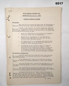
Administrative record - Royal Australian Survey Corps Planning Conference 1972 - Standard of Compilation sheets by LtCol DR Ridge (RASvy), LtCol DR Ridge (RASvy), Fortuna Bendigo, Circa 1972
This is a paper that was prepared for and delivered at the Royal Australian Survey Corps Planning Conference 1972 held at Fortuna Bendigo. The paper was written and delivered by LtCol DR Ridge RASvy.A 6 x A4 page report with typed text, stapled and four hole punchedroyal australian survey corps, rasvy, fortuna, army survey regiment, army svy regt, asr -
Whitehorse Historical Society Inc.
Document, Melbourne and Metropolitan Archaeological survey, 1/03/1982
History of Aboriginal occupation of the Melbourne area. Evidence of shell midden refuse associated with their campsites. Evidence of scarred trees and scatters of stone artefacts along major stream systems. It has been established that man was in the Melbourne area 40,000 years ago and that Aboriginal occupation probably continued uninterrupted throughout the extremes of the last ice age, around 20,000 years ago when Port Phillip itself was dry land. Study will take 2 - 3 years. Aims (1) identify areas of potential archaeological importance (2) implement a pilot survey program (3) prepare comprehensive proposals for survey of sites. (4) liaise and establish rapport with municipal authorities in study area.aborigines, wurundjeri, bunurong, australian heritage commission, victoria. ministry for conservation, victoria archaeological survey -
 Montmorency–Eltham RSL Sub Branch
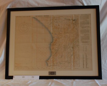
Map - Framed 1915 Anzac Cove Map, Gallipoli, 1915.ANZAC Cove Map, 1915
A framed map depicting trench lines and the battlefields of the Gallipoli Campaign, 1915, made by the Survey Department Egypt. Depth soundings of landing areas off Anzac Cove.Gallipoli - Anzac Cove World War One Map - 1915world war one, anzac, gallipoli, 1915, anzac cove, map, dardenelles, trench lines, depth soundings, landing areas -
 Melbourne Tram Museum
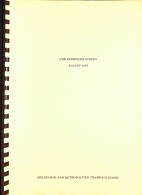
Document - Report, Melbourne & Metropolitan Tramways Board (MMTB), "CBD Passenger Survey - August 1977", Aug. 1977
Report - A4, 58 pages + card coves with brown comb bound, titled "CBD Passenger Survey - August 1977". Has table of contents, tables, figures and notes on the cards. Provides origin and destination information on passengers entering the CBD. Conducted over a two week period using university students.Has "3-10-78" on inside front cover.trams, tramways, surveys, city of melbourne, passengers, mmtb -
Stawell Historical Society Inc
Map, T.F. McGauran, Winjallock County of Kara Kara, 1900
Noth of Navarre and BarkleyA2 Map0f Parish of Kara Kara.Photo Lithographed and the department of Lands & Survey, Melbourne by T.F. McCauran 22.10.00survey -
 Bendigo Military Museum
Photograph - Continuous Indoor Cricket World Record Attempt, Seymour, Victoria, 1986
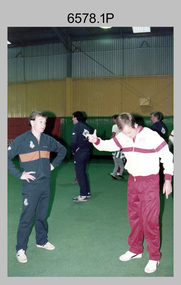
This is a set of 12 photographs of Army teams from the Army Survey Regiment, Bendigo and the Army School of Transport, Puckapunyal attempting a world record playing indoor cricket, at Seymour Victoria from the 31st of January to the 5th of February 1986. The following article appeared on the back page of the ARMY Newspaper on Thursday 6th of March 1986. 'INDOOR CRICKET RECORD SMASHED. ARMY TEAMS from Puckapunyal and Bendigo recently played indoor cricket for 124 hours to set a new world record. The two eight-man teams, from Army School of Transport and Army Survey Regiment, broke the 120 hour record set by Corrimal High School, NSW earlier this year. Organiser of the event, Capt Marty Alsford of AST told ARMY the teams had played 107 games, scoring 15,000 runs in their chase for the record. "The rules allowed a five-minute rest break every hour which could be accrued, so we played for 64 hours straight then had a five hour sleep. "When everybody got up and went straight back into the game with no grumbling, I knew we had the record," Capt Alsford said. The event was held at the Seymour Indoor Cricket Centre, an iron-roofed building with no air-conditioning, and all players had to battle the effect of the stifling heat in addition to fatigue. One player dropped out through exhaustion, but this did not prejudice the record attempt as the rules permitted each team to lose a player who cannot return to the game nor be replaced. The Army teams' effort are now awaiting recognition by the Guinness Book of Records. During the marathon event, the soldiers raised money for Legacy, through sponsorships and a raffle. At the time ARMY went to press, the final figure was not available.’ Army Survey Regiment Routine Orders Part 1 Issue No 16/86 Notices on Page 7 stated: ‘World Record Indoor Cricket. 1. Congratulations to the following members for their successful attempt on the Guinness Book of Records, Record for continuous playing of indoor cricket: John Whaling, Peter Ball, Brenton McDonald, Per Andersen, John Anderson, Brian Fauth, Brett McAllister and Daryl South. 2. Our team, playing a team from Army School of Transport at Seymour played continuous Indoor Cricket for 124 hours, beating the existing record by 4 hours. During that time the two teams amassed a total in excess of 16,000 runs. 3. Congratulations also to Peter Ball for picking up the Trophy for the most outstanding player during the record attempt.’This is a set of 12 photographs of Army teams from Bendigo and Puckapunyal attempting a world record playing indoor cricket, at Seymour Victoria in February 1986. The photographs were printed on photographic paper and are part of the Army Survey Regiment’s Collection. The colour photographs were scanned at 300 dpi. .1) - Photo, colour, 1986, L to R: John ‘Junior’ Whaling, Marty Alsford. Background L to R: Peter Ball, unidentified, John ‘Flash’ Anderson. .2) - Photo, colour, 1986, L to R: John ‘Junior’ Whaling, unidentified, Peter Ball. .3) to .7) - Photo, colour, 1986, unidentified participants. .8) - Photo, colour, 1986, L to R: unidentified, Peter Ball, Brett McAllister, John ‘Junior’ Whaling. .9) - Photo, colour, 1986, L to R: unidentified, John ‘Flash’ Anderson, Brian Fauth, unidentified, Peter Ball, unidentified (x2). .10) - Photo, colour, 1986, Army School of Transport (red & white uniform) - back row L to R: unidentified (x4), front row L to R: unidentified (x3), Marty Alsford. Army Survey Regiment (dark green uniform) - back row L to R: Brett McAllister, John ‘Flash’ Anderson, Brian Fauth, Per Andersen, front row L to R: John ‘Junior’ Whaling, Daryl South, Brenton McDonald, Peter Ball. .11) & .12) - Photo, colour, 1986, Army Survey Regiment (dark green uniform) - back row L to R: Peter Ball, Per Andersen, Brett McAllister, Brian Fauth, front row L to R: Brenton McDonald, John ‘Flash’ Anderson, Daryl South, John ‘Junior’ Whaling..1P to .12P –No personnel are identified. ‘Attempt at World Record for Indoor Cricket 31 Jan - 5 Feb 1986’ annotated on cover sleeve.royal australian survey corps, rasvy, army survey regiment, army svy regt, fortuna -
 Bendigo Military Museum
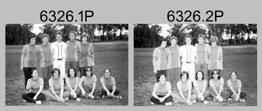
Photograph - Flag Day – Softball, Army Survey Regiment Verses School of Military Survey, Bendigo, 1977
These 25 photographs of softball team and sports action were taken on Flag Day, an annual sports competition between the Army Survey Regiment (ASR) and the School of Military Survey (SMS), at Bendigo on the 13th of May 1977. This event was held at Beischer Park, Strathdale. The two RA Svy units took turns each year to host the event. The day competition usually comprised basketball, cross country, golf, sailing, squash softball, tennis, rifle shooting, touch football, tug-of-war and volleyball. The evening competition often included darts, carpet bowls, hookey, quoits and snooker. See item 6325.15P for photos of golf, sailing, rifle shooting and squash teams and sports action taken on the day. This is a set of 25 photographs of softball team and sports action was taken on Flag Day, Army Survey Regiment (ASR) versus the School of Military Survey (SMS), at Bendigo on the 13th of May 1977. The photographs were printed on photographic paper and are part of the Army Survey Regiment’s Collection. The 35mm positive photographic proofs were scanned at 600 dpi. .1) & 2) - Photo, black & white, 1977, ASR Softball Team - L to R: Tracy (Beckwith) Phillips, unidentified, Gary Ames, Zoe (Lisiewich) Ames, Verity Dixon. Front row L to R: Sue (Nilon) Marner, Chris (Modrow) Stewart, unidentified, Di Chalmers, Lorraine ‘Snoopy’ (Daly) Talbot-Smith. .3) - Photo, black & white, 1977, SMS Softball Team: unidentified participants. .4) & 5) - Photo, black & white, 1977, Softball action: unidentified participants. .6) - Photo, black & white, 1977, Softball action L to R: unidentified (x2), Zoe (Lisiewich) Ames, Chris (Modrow) Stewart, unidentified (x3), Tracy (Beckwith) Phillips. .7) - Photo, black & white, 1977, Softball action L to R: unidentified, Di Chalmers. .8) - Photo, black & white, 1977, Softball action background L to R: unidentified, Ian Belmont, CO LTCOL Bob Skitch, Chris Carter. .9) - Photo, black & white, 1977, Softball action, Chris (Modrow) Stewart. .10) to 12) - Photo, black & white, 1977, Softball action: unidentified participants. .13) - Photo, black & white, 1977, Softball action: L to R: unidentified (x3), Lorraine ‘Snoopy’ (Daly) Talbot-Smith. .14) - Photo, black & white, 1977, Softball action: unidentified participants. .15) - Photo, black & white, 1977, Softball action: L to R: unidentified (x2), Lorraine ‘Snoopy’ (Daly) Talbot-Smith. .16) - Photo, black & white, 1977, Softball action: L to R: Sue (Nilon) Marner, unidentified, Lorraine ‘Snoopy’ (Daly) Talbot-Smith, unidentified. .17) - Photo, black & white, 1977, Softball action: unidentified participants, spectators L to R: unidentified, Peter Dew, Trevor Pearson, Alan Staley, Gavin Neilson, Ian Belmont, unidentified, Chris Carter. .18) - Photo, black & white, 1977, Softball action: unidentified participants and spectators. .19) & .20) - Photo, black & white, 1977, Softball action: unidentified participants, catcher Lorraine ‘Snoopy’ (Daly) Talbot-Smith. .21) - Photo, black & white, 1977, Softball action L to R: unidentified (x2), Chris (Modrow) Stewart, Tracy (Beckwith) Phillips, Lorraine ‘Snoopy’ (Daly) Talbot-Smith. .22) - Photo, black & white, 1977, Softball action: unidentified participants. .23) - Photo, black & white, 1977, Softball action L to R: Frank Lenane, Di Chalmers, Lorraine ‘Snoopy’ (Daly) Talbot-Smith, Zoe (Lisiewich) Ames, unidentified (x2). .24) & .25) - Photo, black & white, 1977, Softball action: unidentified participants..1P to .25P –No personnel are identified.royal australian survey corps, rasvy, army survey regiment, army svy regt, school of military survey, fortuna, asr, flag day -
Port Melbourne Historical & Preservation Society
Letter - Department of Lands and Survey re proclaimation of Beach Street, Sandridge, Department of Lands and Survey, 16 Mar 1861
Handwritten letter on blue foolscap laid paper, from Dept of Lands and Survey 16.3.1861, directing attention to proclamation in Government Gazette re Beech Street (sic) Sandridgelocal government - borough of sandridge, engineering - roads streets lanes and footpaths -
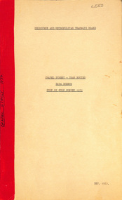 Melbourne Tram Museum
Document - Report, Melbourne & Metropolitan Tramways Board (MMTB), "Chapel Street - Tram Routes - Data Sheets - Stop by Stop survey 1972", Dec. 1972
Report - Foolscap, card covers, red tape binding, 10 pages, titled "Chapel Street - Tram Routes - Data Sheets - Stop by Stop survey 1972" Maps running times and summary including a check across conductors journals. Dated Dec 1972, notes work done by L Hogan, W. TootellHas "Lees" in the top right hand corner and the title on the left side of the report.trams, tramways, routes, passengers, planning, development, chapel st -
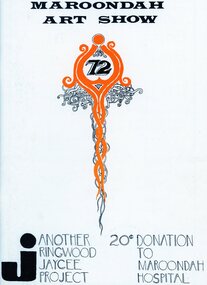 Ringwood and District Historical Society
Document, Packet: Ringwood Jaycees - Art Show Programmes 1975; Development Project 1962-1963; Junior Jaycees Art Show 1972; Survey 1967
Packet includes the following: . Ringwood Junior Chamber of Commerce- Community Development Project, 1962-63. . 1967 Ringwood Community Survey- conducted by the Ringwood Jaycees. . Maroondah Art Show 1972. . Maroondah Art Show 1969. . Programme- Junior Chamber International Senate Award for Stan Morris, March 20th, 1969. . Maroondah Art Show 1975. -
Whitehorse Historical Society Inc.
Letter - Correspondence, Office of Lands and Survey, 1861
Copy of letter written by W. Fletcher, Office of Lands and Survey, Melbourne, 2 Nov 1861.Copy of letter written by W. Fletcher, Office of Lands and Survey, Melbourne, 2 Nov 1861. Reporting that charcoal burners in the Parish of Nunawading are using wood for that purpose without a license and suggesting the policeman at Whitehorse by informed. Attached note suggests author is possibly Walter Thomas Fletcher, early owner of land that included what is now Matheson's orchard (1988).Copy of letter written by W. Fletcher, Office of Lands and Survey, Melbourne, 2 Nov 1861.charcoal burning, fletcher, w, forest hill, parish of nunawading -
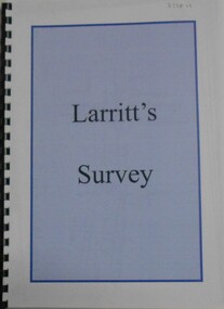 Bendigo Historical Society Inc.
Book - LARRITT'S SURVEY, 1854-1860
Larritt's Survey Enlarged mapsrichard larritt, survey, goldfields -
Port Melbourne Historical & Preservation Society
Plan, Department of Lands and Survey, The Township of Sandridge, 25 Nov 1860
Plan of the township of Sandridge lithographed at the department of Lands and Survey, Melbourne 5th November, 1860. Identical to 1859 version except for added rail line through Sandridge and onto Town Pierengineering - roads streets lanes and footpaths, municipal district of sandridge -
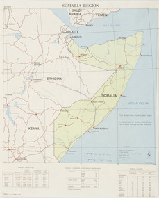 Beechworth RSL Sub-Branch
Map - Map Somalia Region, 1992
This map was used for briefing purpose only as the relief data is incomplete. Double sided coloured paper map of the Somalia Region with a 1:2 250 000 scale. Display side - PRODUCED AND PRINTED BY / 1 TOPO SVV SQN / ROYAL AUSTRALIAN SURVEY CORPS / DECEMBER 1992 DEF/ARMY 20463 / -
 Greensborough Historical Society
Book, Isabel Ellender, The Plenty Valley Corridor: the archaeological survey of Aboriginal sites / by Isabel Ellender 1991, 1991_
This archaeological survey of the Plenty Valley was conducted by Isabel Ellender in 1991 for the Board of Works (Melbourne Water), in particular the Plenty Gorge Metropolitan Park. The area studied is north of Greensborough to Whittlesea. A number of Aboriginal sites were identified and recommendations made for the future.67 p., illus., maps. Plastic spiral binding.plenty river, aboriginal heritage sites, plenty gorge metropolitan park -
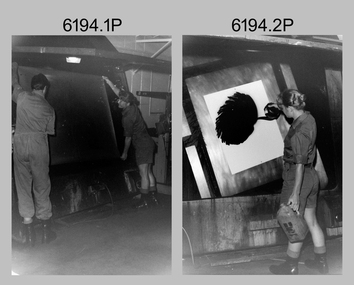 Bendigo Military Museum
Photograph - Lithographic Technicians and Equipment at the Army Survey Regiment, Fortuna Villa Bendigo, c1990s
These 10 photographs were most likely taken in the 1990s in Lithographic Squadron at the Army Survey Regiment, Fortuna, Bendigo. In photos .1P to .2P the technicians are applying a UV-sensitive pigmented dye emulating one of the print colours to a white opaque polyester sheet mounted on a rotating table in a whirler. The coated sheet was dried before placement in a vacuum light frame beneath a stud registered map negative. They were then exposed to a carbon arc lamp. For more photos and details on the process, see item 6059.5P. In photos .3P to .5P the technician is preparing a orthophotomap film positive. Photo .6P is the rear view of the tri-linear film punch. In photos .7P and .8P the technician is operating a heavy-duty guillotine to trim bulk printed map stock. Cartographers normally provided trim marks to specified map dimensions as guidance to the printer. The trimming stage, like all the other printing processes required high levels of accuracy. These guillotines were extremely powerful to cut through bulk quantities of printed maps. For more photos and details on this process, see item 6069.6P. In photo .9P the technician is operating a daylight film contacting frame. In photo .10P LT Ian Stoddart is taking a well-earned break.This is a set of 10 photographs of lithographic technicians undertaking tasks at the Army Survey Regiment, Bendigo c1990s. Photos .1P to .7P and .9P to .11P are on 35mm negative film and scanned at 96 dpi. Photo .8P is printed on photographic paper and scanned at 300 dpi. They are part of the Army Survey Regiment’s Collection. .1) and .2) - Photo, black & white, c1990s, unidentified printer technician and SPR Janet Murray using the map proof whirler. .3) to .5) - Colour, c1990s, Mick ‘Buddha’ Ellis preparing an orthophotomap film positive. .6) - Photo, Colour, c1990s, rear view of tri-linear film punch. .7) & .8) - Photo, Colour, c1990s, unidentified technician operating a heavy-duty guillotine. .9) - Photo, Colour, c1990s, printer technician SPR Shona Hastie operating a daylight film contacting frame. .10) - Photo, Colour, c1990s, LT Ian Stoddart taking a well-earned break. .1P to .10P– no annotationroyal australian survey corps, rasvy, army survey regiment, army svy regt, fortuna, asr, litho -
 Robin Boyd Foundation
Booklet, P. R. Boyd, Survey on Melbourne, 1960
In 1960 when he was 11 years old, Penleigh Boyd, Patricia and Robin's son, created this 'Survey on Melbourne’ as a school project. He went on to study architecture at the University of Melbourne and the University of Sydney. He has worked as an architect in Canberra since 1976.Notebook with handwritten notes in blue ink and newspaper clippings (which open), paper cover.walsh st library, ohm2022, ohm2022_37 -
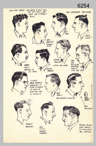 Bendigo Military Museum
Drawing - Land Headquarters Cartographic Company’s Cricket Team Sketches, Fortuna, Bendigo, c1943
This is a page containing portrait profile sketches of 14 members of Fortuna’s cricket team, possibly taken from a booklet published at Bendigo’s Land Headquarters Cartographic Company circa 1943. Fortuna’s involvement in the Bendigo community and local sporting competitions in the 1940s is covered in page 31 of Valerie Lovejoy’s book 'Mapmakers of Fortuna – A history of the Army Survey Regiment’ ISBN: 0-646-42120-4. It is noted Fortuna’s Cricket Team competed in the summer of 1943. From the annotations of each individual’s name or nickname and other comments, the team members were probably V15403 SGT RC Papworth, 315649 HR Webster, V301426 SGT JR Neander, V510526 SPR RL Neander, VX85797 SGT WH Eddy, VX121647 SGT KH Harris, VX110276 CPL HM Jackson or VX119801 LR Jackson, VX37958 CPL DD Milligan, VX37958 SPR RJ Barber, VX85798 WO2 RR Pratt, VX85805 SGT GW Vallence, VX86152 CP LA Burford, V275492 SGT Ron Little and VF510725 SPR VM Bond or VX100878 WO2 WJ Bond. This is a page containing profile sketches of 14 members of Fortuna’s cricket team, possibly taken from a booklet published at Bendigo’s Land Headquarters Cartographic Company circa 1943. Each sketch is annotated with the individual’s name or nickname, and some have witty comments in relation to their cricketing prowess. The black and white A4 size portrait sketch was printed on a single buff manilla card and are part of the Army Survey Regiment’s Collection. The sketch was scanned at 300 dpi. Each sketch is annotated: Top Row L to R: SLAP HAPPY PAPPY - CAN DRIVE A GOLF BALL OUT OF SIGHT - BUT CAN’T SEE A CRICKET BALL, HEC. WEBSTER – HOOKEY KING, THE NEANDER BROTHERS BOB, JACK “LUCKY”. Second Row L to R: BARRY EDDY – BETTER AT THE MIKE, KEITH HARRIS, SCHNOZ JACKSON - NOSE THE GAME, CAPT. DON MILLIGAN WONDERS HOW TO STOP THE ROT. 3rd Row L to R: SCORER RALPH BARBER LEARNING TO TYPE IN ORDER TO KEEP UP WITH THE FALL OF WICKETS, BOB PRATT OUR HERBERT SUTCLIFFE, BILL VALLENCE, Bottom Row L to R: TORCHY BURFORD, RON LITTLE WICKET KEEPER, DOCTOR BOND – USED MAINLY TO INFLUENCE THE UMPIRE. royal australian survey corps, rasvy, army survey regiment, army svy regt, fortuna -
Ringwood and District Historical Society
Map, Government Printer, Melbourne, Ringwood Zone Ordinance Survey Map, 1935
Ordinance survey map glued to cheesecloth, of Ringwood zone - Commonwealth topographical map dated 1.8.35, scale 1:63,360. Information correct up to June 1922. "Ringwood 81" printed on the reverse side.; Envelope and note from donor of item, with return letter of appreciation from Ringwood & District Historical Society dated 20-May-2005. +Additional Keywords: Reid, Don -
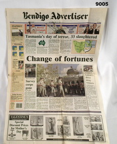 Bendigo Military Museum
Newspaper - Bendigo Advertiser - "Change of Fortunes" - Army Survey Regiment bids farewell to Bendigo, Bendigo Advertiser Newspaper, 27th and 29th April 1996
The article describes the Army Survey Regiment's farewell to Bendigo with a final parade to hand back the "Freedom of the City" key. A smaller article on the second page describes the taking over of the mapping by the "Army Topographic Support Agency" (ATSE) which was a Defence Public Service based organisation. Newspaper Article of 2 pages, approx A3 sizeroyal australian survey corps, rasvy, fortuna, army survey regiment, army svy regt, army topographical support establishment, atse -
Port Melbourne Historical & Preservation Society
Letter - Department of Lands and Survey re proclaimation for site of Town Hall, Sandridge, Department of Lands and Survey, 30 Dec 1861
Handwritten letter on blue foolscap laid paper, from Dept of Lands and Survey 30.12.1861 directing attention to proclamation in Government Gazette re site for Town Hall at Sandridge. Paper, watermarked with Britannia symbollocal government - borough of sandridge, port melbourne town hall -
 Bayside Gallery - Bayside City Council Art & Heritage Collection
Photograph, Department of Crown Lands and Survey, Victoria, Melbourne Project: Brighton, 1976
The Department of Crown Lands and Survey (1857-1983) was responsible for the administration of survey and mapping and the sale, occupation and management of crown land throughout its existence. This aerial photograph shows parts of Brighton and was taken on 1 December 1976brighton, department of crown lands and survey, aerial photograph, bayside, port phillip bay, map, cartographic material, melbourne project 1976, brighton yacht club, middle brighton baths, north road, st kilda street, new street -
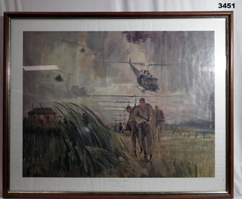 Bendigo Military Museum
Print - PRINT, FRAMED, Print reproduced by the Royal Australian Survey Corps
Reproduced by kind permission of the Australian War Memorial by Royal Australian Survey Corps 1985. Brown wooden frame with gold inner trim & glass front. Mounted with white border & brown paper frame backing. Copy of coloured painting of Landing At Duc Thanh. Original by B Fletcher.Brown wooden frame with gold inner trim & glass front. Mounted with white border & brown paper frame backing. Copy of coloured painting of Landing At Duc Thanh. Original by B Fletcher.RHS bottom corner: Artist's signatureroyal australian survey corps, rasvy -
 Kiewa Valley Historical Society
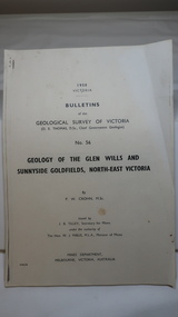
Document - Four Geological reports on the North-east Goldfields, Geological Survey of Victoria 1958 Bulletin
Geological Surveys of N.E. Goldfields Victoria included mines and tunnels. A resurvey of goldfields was necessary to re-assess economic possibilities using modern techniques and structural interpretation. It included an examination of a considerable surface area with maps and underground workings. Results were correlated and integrated and published by the Mines Department.The mines are in the Bogong Alpine Area.Foolscap printed Victorian Bulletins. Each stapled in the top left corner and each with varying number of pages. Covering 1941-1958 a) Glen Wills and Sunnyside b) Sunnyside Tunnel c) Red Robin d) Maud and Yellow Girl Government Printer, Mines Department, Melbourne, Victoriageology in the north-east, gold fields, goldmines, glen wills -
 Melbourne Tram Museum
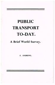
Book, F. Andrews, "Public Transport Today; A brief World Survey", late 1960's early 1970's
Twenty page booklet, centre stapled, printed with photographs on glossy paper, titled "Public Transport Today; A brief World Survey", by F. Andrews of Queensland, late 1960's early 1970's. Looks at the current developments in light rail, tramways, transit lines, in North America, Continental Europe and the future in public transport. Has many photographs of tramways and tramcars. Two copies held.trams, tramways, public transport, tramways, europe, usa, canada