Showing 22698 items
matching yarra
-
 Melbourne Tram Museum
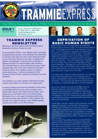
Pamphlet, Yarra Trams, "Trammie Express - Issue 1 - 25/7/2013", Jul. 2013
Full colour A4 double sided sheet, titled "Trammie Express - Issue 1 - 25/7/2013", issued by the RTBU as an occasional newsletter - not known if further issues. Main item is "Depravation of Basic Human Rights", looking at an incident between Yarra Trams Management and workers at East Preston Depot. Also has items on Insulated Tram Incidents and RTBU Holiday Units.trams, tramways, rtbu, yarra trams, east preston, unions -
 Melbourne Tram Museum
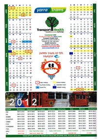
Ephemera - Calendar, Yarra Trams, 2011
Printed A4 calendar on matt paper, full colour providing dates for 2012 including public and school holidays, Australian Open, Grand Prix, Pay weeks and Daylight saving, phone numbers for contacts at each depot, Yarra Trams logo and a symbol for the "The Happy Year of the Dragon". Also has details of Transport Health Insurance. Has a part photo of Z3 158, the Royal Tram.trams, tramways, yarra trams, calendar, tram 158 -
 Eltham District Historical Society Inc
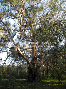
Photograph, Fay Bridge, Yellow Box Gum tree near junction of Main Yarra Trail and Mullum-Mullum Trail, Templestowe, 7 July 2019
Situated in the wetlands on the trail opposite the Pontville Homestead, former home of Major Charles Newman and across the Yarra River from Sweeneys Flats, Eltham. Newman also purchased Allotment 5, Section 2 (in Ely Street, Eltham) at public autction on 17 September 1851. It was the only Section 2 allotment purchased at the firts Elthan Town Allotments public auction.fay bridge collection, sweeneys flats, 2019-07-07, major charles newman, mullum mullum creek, pontville homestead, significant tree, yellow box gum (eucalyptus melliodora) -
 Greensborough Historical Society
Map, Melbourne and Metropolitan Board of Works. Survey Division, MMBW, Yarra 2500 / 14.22. St Helena, St Katherine's Church, 1979_08
Melbourne and Metropolitan Board of Works. Yarra 2500 [base map] 14.22. St Helena, St Katherine's Church. Parish of Nillumbik 3310. Municipality of Diamond Valley 257. Prominent streets St Helena Road, Weidlich Road, Yan Yean Road and Allumba Drive. Features include St Katherine's Church of England and the St Helena Secondary College site.MMBW Map in 1:2500 [scale] series. Cream parchment with green tape reinforcing on edges and punched holes on left edge.mmbw, melbourne and metropolitan board of works, shire of diamond valley, st helena - maps, st katherines church st helena -
 Vision Australia
Text, RVIB Yarra Glen Auxiliary, 1956 - 1997
The Yarra Glen RVIB Auxiliary formed on March 19, 1956. This small collection contains index cards which were maintained by RVIB and contain the amount of donations made by the Auxiliary between 1976 - 1995 as well as the presentations delivered by RVIB employees to Auxiliary meetings between 1978 - 1985. Correspondence to and from RVIB head office ranging between 1990 - 1999. Newspaper articles -- letters -- index cards and various loose papers royal victorian institute for the blind -
 Greensborough Historical Society
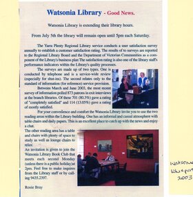
Article - Newspaper Clipping and Flyer, Watsonia Traders Association, Watsonia Library: Good News: Watsonia Library is extending their library hours, 05/07/2003
Watsonia Library extends Saturday opening hours in July 2003. Newspaper clipping from Watsonia's Whisper and flyer from Yarra Plenty Regional Library (YPRL) inviting patrons to the opening celebrations.News article. Black, red and blue text and colour image on colour background. yarra plenty regional library, yprl, watsonia library -
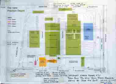 Melbourne Tram Museum
Drawing - New Preston Depot layout - annotated, Yarra Trams, 2015
A drawing from Yarra Trams' in-house magazine, The Wire, No. 86, 4/6/2014, shows the layout of New Preston depot. Has been annotated by Norm Cross 1/1/2015.Yields information about the layout of the New Preston Depot and workshops.Drawing mounted onto a corrugated cardboard sheet with hand written annotations.trams, tramways, new preston depot, preston workshops, drawings -
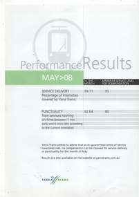 Melbourne Tram Museum
Poster, Yarra Trams, "Performance Results M>08", May 2008
An example of a Yarra Trams poster that was provided in tramcars to advise passengers of their performance during May 2008 - giving details of service delivery and punctuality and that they met their service delivery requirements under their contract with the Victorian Government.Demonstrates a Yarra Trams poster regarding service delivery and performance.Document - single A4 sheet, colour trams, tramways, yarra trams, services, franchise -
 Eltham District Historical Society Inc
Negative - Photograph, J.A. McDonald, Eltham-Yarra Glen Road, Lower Plenty footbridge, Sep. 1955
The Eltham-Yarra Glen Road as designated originated at the Shire of Eltham boundary at the Plenty River. West of the river the road was known as the Heidelberg-Eltham Road. The section from the Plenty River is now known as Lower Plenty Road which becomes Main Road. The footbridge no longer exists but was originally sited to the south, adjacent to the old Lower Plenty Bridge, now part of the Plenty River Trail. Record of various Shire of Eltham infrastructure works undertaken during the period of 1952-1962 involving bridge and road reconstruction projects, sometimes with Eltham Shire Council Project Reference numbers quoted. It was during this period that a number of significant improvements were made to roads and new bridges constructed within the shire that remain in place as of present day (2022). In many situations, the photos provide a tangible visible record of infrastructure that existed throughout the early days of the Shire. The album was put together by or under the direction of the Shire Engineer, J.A. McDonald.1955-09, eltham-yarra glen road, lower plenty footbridge, lower plenty, lower plenty bridge, lower plenty road, main road, plenty river trail, bridge construction, infrastructure, shire of eltham -
 Eltham District Historical Society Inc
Slide - Photograph, Eltham-Yarra Glen Road, Kangaroo Ground c.1910, c.Aug. 1990
Part of a presentation, "Roads and Byways of the Shire of Eltham", by Russell Yeoman to the 12 September 1990 Society meeting. Slides shown included copies of old photos and recent images ranging from the suburban streets of Eltham and Montmorency to the mountain roads of Kinglake. In the byways category are views of some iof the Shire's bicycle paths including then recently completed sections of the Main Yarra Trail at Lower Plenty.35mm colour positive transparency (1 of 37) Mount - Agfachrome Agfa CS System black 8 dotsinfrastructure, roads, eltham-yarra glen road, kangaroo ground -
 Eltham District Historical Society Inc
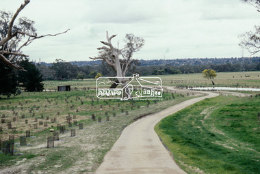
Slide - Photograph, Main Yarra Trail, Lower Plenty, c.Aug. 1990
Part of a presentation, "Roads and Byways of the Shire of Eltham", by Russell Yeoman to the 12 September 1990 Society meeting. Slides shown included copies of old photos and recent images ranging from the suburban streets of Eltham and Montmorency to the mountain roads of Kinglake. In the byways category are views of some iof the Shire's bicycle paths including then recently completed sections of the Main Yarra Trail at Lower Plenty.35mm colour positive transparency (1 of 37) Mount - Agfachrome Agfa CS System black 8 dotsinfrastructure, bonds road, lower plenty, main yarra trail, roads, significant trees -
 Eltham District Historical Society Inc
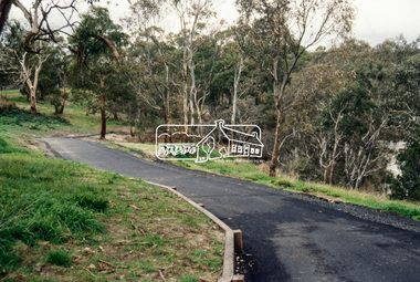
Slide - Photograph, Main Yarra Trail, Lower Plenty, c.Aug. 1990
Part of a presentation, "Roads and Byways of the Shire of Eltham", by Russell Yeoman to the 12 September 1990 Society meeting. Slides shown included copies of old photos and recent images ranging from the suburban streets of Eltham and Montmorency to the mountain roads of Kinglake. In the byways category are views of some iof the Shire's bicycle paths including then recently completed sections of the Main Yarra Trail at Lower Plenty.35mm colour positive transparency (1 of 37) Mount - Agfachrome Agfa CS System black 8 dotsinfrastructure, bonds road, lower plenty, main yarra trail, roads, yarra river -
 Eltham District Historical Society Inc
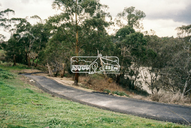
Slide - Photograph, Main Yarra Trail, Lower Plenty, c.Aug. 1990
Part of a presentation, "Roads and Byways of the Shire of Eltham", by Russell Yeoman to the 12 September 1990 Society meeting. Slides shown included copies of old photos and recent images ranging from the suburban streets of Eltham and Montmorency to the mountain roads of Kinglake. In the byways category are views of some iof the Shire's bicycle paths including then recently completed sections of the Main Yarra Trail at Lower Plenty.35mm colour positive transparency (1 of 37) Mount - Agfachrome Agfa CS System black 8 dotsinfrastructure, bonds road, lower plenty, main yarra trail, roads, yarra river -
 Eltham District Historical Society Inc
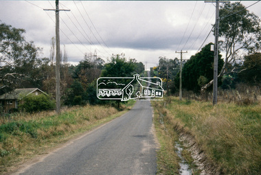
Slide - Photograph, Main Yarra Trail, Lower Plenty, c.Aug. 1990
Part of a presentation, "Roads and Byways of the Shire of Eltham", by Russell Yeoman to the 12 September 1990 Society meeting. Slides shown included copies of old photos and recent images ranging from the suburban streets of Eltham and Montmorency to the mountain roads of Kinglake. In the byways category are views of some iof the Shire's bicycle paths including then recently completed sections of the Main Yarra Trail at Lower Plenty.35mm colour positive transparency (1 of 37) Mount - Agfachrome Agfa CS System black 8 dotsinfrastructure, bonds road, lower plenty, roads -
 Eltham District Historical Society Inc
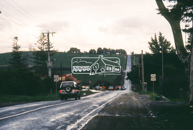
Slide - Photograph, Kangaroo Ground Supply Store, Eltham-Yarra Glen Road, Kangaroo Ground, c.Aug. 1990
Part of a presentation, "Roads and Byways of the Shire of Eltham", by Russell Yeoman to the 12 September 1990 Society meeting. Slides shown included copies of old photos and recent images ranging from the suburban streets of Eltham and Montmorency to the mountain roads of Kinglake. In the byways category are views of some iof the Shire's bicycle paths including then recently completed sections of the Main Yarra Trail at Lower Plenty.35mm colour positive transparency (1 of 37) Mount - Agfachrome Agfa CS System black 8 dotsinfrastructure, roads, eltham-yarra glen road, kangaroo ground, kangaroo ground store, kangaroo ground supply store -
 Eltham District Historical Society Inc
Slide - Photograph, Eltham-Yarra Glen Road, Kangaroo Ground, c.Aug. 1990
Part of a presentation, "Roads and Byways of the Shire of Eltham", by Russell Yeoman to the 12 September 1990 Society meeting. Slides shown included copies of old photos and recent images ranging from the suburban streets of Eltham and Montmorency to the mountain roads of Kinglake. In the byways category are views of some iof the Shire's bicycle paths including then recently completed sections of the Main Yarra Trail at Lower Plenty.35mm colour positive transparency (1 of 37) Mount - Agfachrome Agfa CS System black 8 dotsinfrastructure, roads, eltham-yarra glen road, kangaroo ground, kangaroo ground store, kangaroo ground supply store -
 Eltham District Historical Society Inc
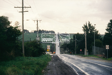
Slide - Photograph, Eltham-Yarra Glen Road, Research, c.Aug. 1990
Part of a presentation, "Roads and Byways of the Shire of Eltham", by Russell Yeoman to the 12 September 1990 Society meeting. Slides shown included copies of old photos and recent images ranging from the suburban streets of Eltham and Montmorency to the mountain roads of Kinglake. In the byways category are views of some iof the Shire's bicycle paths including then recently completed sections of the Main Yarra Trail at Lower Plenty.35mm colour positive transparency (1 of 37) Mount - Agfachrome Agfa CS System black 8 dotsinfrastructure, roads, research (vic.), cassells road, eltham-yarra glen road -
 Eltham District Historical Society Inc
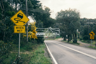
Slide - Photograph, Eltham-Yarra Glen Road, Research, c.Aug. 1990
Part of a presentation, "Roads and Byways of the Shire of Eltham", by Russell Yeoman to the 12 September 1990 Society meeting. Slides shown included copies of old photos and recent images ranging from the suburban streets of Eltham and Montmorency to the mountain roads of Kinglake. In the byways category are views of some iof the Shire's bicycle paths including then recently completed sections of the Main Yarra Trail at Lower Plenty.35mm colour positive transparency (1 of 37) Mount - Agfachrome Agfa CS System black 8 dotsinfrastructure, roads, research (vic.), eltham-yarra glen road -
 Eltham District Historical Society Inc
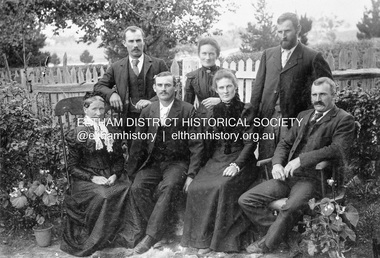
Photograph, Gulf Station, Yarra Glen. Members of the Bell Family, 1905c
Mrs Bell and her adult children of Gulf Station, Yarra Glen. Standing Jack (John), Jemima, Andrew. Seated Mary Ann (mother of all the others), Frank (Francis), Dinah and Bill (William). Scottish settlers Agnes and William Bell were the first to lease the land where the property was established in the 1850s. Gulf Station was farmed for nearly 100 years by the Bell family.This photo forms part of a collection of photographs gathered by the Shire of Eltham for their centenary project book,"Pioneers and Painters: 100 years of the Shire of Eltham" by Alan Marshall (1971). The collection of over 500 images is held in partnership between Eltham District Historical Society and Yarra Plenty Regional Library (Eltham Library) and is now formally known as 'The Shire of Eltham Pioneers Photograph Collection.' It is significant in being the first community sourced collection representing the places and people of the Shire's first one hundred years.Digital imagesepp, shire of eltham pioneers photograph collection, yarra glen, bell family, gulf station, dianah bell, frank bell, jack bell, jimima bell, mary ann bell, william bell -
 Melbourne Tram Museum
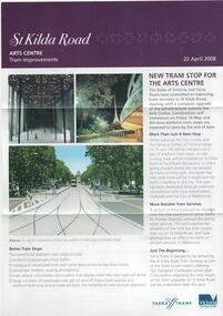
Pamphlet, Yarra Trams, "St Kilda Road - Arts Centre Tram Improvements", April 2008
Pamphlet - 3 fold A4 pamphlet, full colour, titled "St Kilda Road - Arts Centre Tram Improvements" detailing the construction schedule and photos of the Superstops and additional tracks outside the Arts Centre in St Kilda Road. Shows a track layout including a revised junction for South Melbourne Trams and Southbank Boulevard. Has Yarra Trams and State Government logos. Dated 24/4/2008.trams, tramways, st kilda rd, arts centre, road works, superstops -
 Melbourne Tram Museum
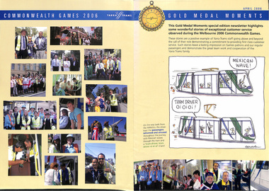
Newsletter, Yarra Trams, "Gold Medal Moments - April 2006", Apr. 2006
Newsletter - two fold A4, full colour titled "Gold Medal Moments - April 2006", featuring a Golding cartoon on the front cover, about the 2006 Melbourne Commonwealth Games. Has many comments from passengers, including of Z81, Karachi tram and many photos. Included in the item is a letter from the Premier of Victoria, Steve Bracks and Minister for Transport, congratulating Yarra trams and staff for the event.trams, tramways, yarra trams, commonwealth games, karachi, passengers, cartoons, tram 81 -
 Melbourne Tram Museum
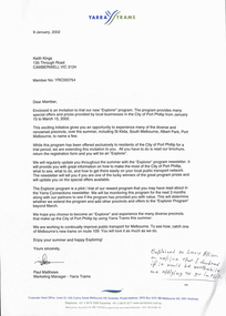
Letter, Yarra Trams, "Explore", Jan. 2002
Letter from Yarra Trams to Keith Kings, 9/1/2002, advising of the new "Explorer" program for use in the City of Port Phillip, part of a trial - lists Metcard retailers and where discounts could be obtained from food or coffee shops. Has a hand written note that Keith advised Lucy Allison that it probably not be worthwhile being a part of the program. Signed by Paul Matthews as Marketing Manager.trams, tramways, yarra trams, city of port phillip, marketing -
 Melbourne Tram Museum
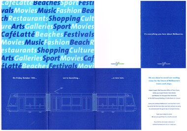
Document - Invitation, Yarra Trams, launch of the C class tram, Sep. 2001
Invitation card - four fold printed on white paper, inviting people to the launch of the C class tram, and Superstops in Collins St on 12 October. 2001. Invitation from Hubert Guyot CEO Yarra Trams, Victorian Premier Steve Bracks, Minister for Transport - Peter Batchelor. Also celebrated the launch of route 109. Image has a drawing of a C class tram. Two copies held.trams, tramways, yarra trams, c class, superstops, collins st, launch, opening -
 Melbourne Tram Museum
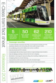
Pamphlet, Yarra Trams, "E Class Tram fact sheet", Dec. 2013
Pamphlet - A4 printed on gloss paper titled "E Class Tram fact sheet", detailing the new (2013) E class tramcars with photos of 6002, passenger amenities, technical information and general details. Has photos, sketches of the tramcar. Has the Yarra Trams and PTV logos. This sheet was issued to tour participants of the 14/11/2015 Ruby Tour of the Z class trams. Two copies held.trams, tramways, e class, specification -
 Melbourne Tram Museum
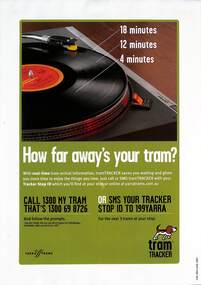
Poster, Yarra Trams, "How far away's your tram?", June 2007
Poster promoting the use of Yarra Tram's tramTracker system using the image of a vinyl record player. Has the details of how to do it by SMS or by a phone call. Produced in June 2007 when the system was relatively new.Demonstrates the marketing of the tramTracker system.Full colour poster printed on an A4 sheet, approx 150gsm paper.trams, tramways, posters, tramtracker, yarra trams -
 Melbourne Tram Museum
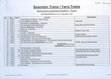
Document - List, Swanston Trams, "Destinations and Route Numbers - Trams", 9/2000
List of "Destinations and Route Numbers - Trams" dated 3/9/2000 for both Yarra and Swanston Trams. Lists depot and number, the main route number, termini and destination. Also provides a list by each depot.Yields information about the Melbourne tram route numbers and the depots that operated them in Sept. 2000.Document - 14 A4 pages, was stapled in top left hand corner.melbourne, tramways, route numbers, destinations, yarra trams, swanston trams -
 Greensborough Historical Society
Map, Melbourne and Metropolitan Board of Works. Survey Division, MMBW, Yarra 2500 / 12.24. Plenty and Blue Lake, 1977_10
Melbourne and Metropolitan Board of Works. Yarra 2500 [base map]. 12-24, Municipalities of Whittlesea 239 and Diamond Valley 257. Shows street names, easement sizes, lot numbers, lodged plan numbers, names of prominent features, contour values, creek or river names. Watsonia Railway Station and environs. Prominent streets: Memorial Drive. Includes Plenty River and Blue Lake in the Plenty Gorge.MMBW Map in 1:2500 [scale] series. Cream parchment with green tape reinforcing on edges and punched holes on left edge.mmbw, melbourne and metropolitan board of works, shire of diamond valley, plenty - maps, blue lake -
 Melbourne Tram Museum
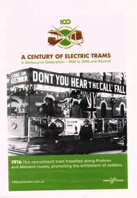
Poster, Yarra Trams, "A Century of Electric Trams", 2006
Set of four posters issued by Yarra Trams to celebrate A Century of Electric Trams" in 2006. Each have the 100 years logo on the top of the poster, the title "A Century of Electric Trams", with the byline - "A Melbourne Celebration - 1906 to 2006 and Beyond". On the bottom is the website name. "100yearstrams.com.au" and the Yarra Trams logo. A caption for each photo is under the photograph. .1 - General poster for the "100 years of electric trams in Melbourne" event, featuring the logo, details of the event and web site. - A4. .2 - ditto - A3 size. ,3 - Flinders St Station c1935 x A3 .4 - ditto - A4 size .5 - photo of the 1916 PMTT Recruitment tram - A4 size .6 - ditto - A3 size .7 - W2 244 travelling on the East Preston line with people hanging out - on the way to the Fitzroy Football Ground - A4 size. .8 - ditto - A3 size. two copies of each held.trams, tramways, mmtb, pmtt, 100 years of electric trams, fitzroy, decorated trams, football, flinders st station, world war 1 -
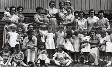 Melbourne Water
Photograph, Upper Yarra Dam Personnel, 1955
As the Yarra became unsuitable as a source of water, several attempts were made to find alternative sources for the growing population of Melbourne. It was not until 1891 that the efforts to sewer Melbourne came to fruition with the setting up of the Melbourne Metropolitan Board of Works (MMBW), now known as Melbourne Water. From 1891 until 1992, it was the responsibility of the MMBW to safeguard public health by providing a sewerage system and a safe water supply system. In 1992, The MMBW merged with a number of smaller urban water authorities to form Melbourne Water. In 1946, the Melbourne and Metropolitan Board of Works (MMBW) approved a site for a new dam for Melbourne's domestic water. This is now known as the Upper Yarra Dam. Due to the construction of the dam, the workforce had to be accommodated on site; domestic quarters were built for single men, families and staff. The township also had kitchens, laundry facilities, a canteen, a recreation hall, mess areas and a co-op store, with one of the first houses being seconded to accommodate for a school. This photograph shows personnel at a Kindergarten party at the Upper Yarra Dam, a time where workers were housed during its construction. The photograph is historically significant as it captures a purpose built community that supported the workers undertaking the construction of the dam. upper yarra dam, mmbw, melbourne metropolitan board of works, township, 1940s, community