Showing 10891 items
matching land
-
 Eltham District Historical Society Inc
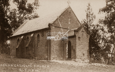
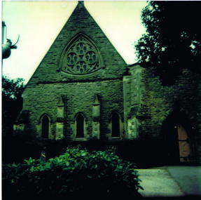
Negative - Photograph, St Mary's Roman Catholic Church, Eltham, c.1910
Note the extensive cracking of the mortar and bricks in the front facade near the portico entrance. The original St Mary’s Roman Catholic Church (1865-1912) was built of clay brick with buttress walls and a slate roof on the corner of Fordhams Road and Maria Street (Main Road), Eltham South, opposite the present-day Wingrove Park. It was blessed on September 3, 1865. With the arrival of the railway in 1901 and the town centre moving closer to the station, the decision was made to relocate the site of the church to its present-day location on Henry Street at the corner of Main Road. A new timber weatherboard church, also called St Mary's was erected and blessed on October 13, 1912. The church and land cost £1,400 (Evelyn Observer). The original brick church It was demolished in the 1920s and the bricks and windows were recycled to build a dairy on the Brinkkotter farm at Research. The timber church was destroyed by fire in 1961 and a new modern architectural (1960s) style church was erected in its place and named Our Lady of Help Christians Church.This photo forms part of a collection of photographs gathered by the Shire of Eltham for their centenary project book,"Pioneers and Painters: 100 years of the Shire of Eltham" by Alan Marshall (1971). The collection of over 500 images is held in partnership between Eltham District Historical Society and Yarra Plenty Regional Library (Eltham Library) and is now formally known as the 'The Shire of Eltham Pioneers Photograph Collection.' It is significant in being the first community sourced collection representing the places and people of the Shire's first one hundred years.Digital image 4 x 5 inch B&W Neg Sepia postcardsepp, shire of eltham pioneers photograph collection, eltham, roman catholic church, church, catholic church, main road, st marys catholic church -
 4th/19th Prince of Wales's Light Horse Regiment Unit History Room
Medal, Italy Star, abt 1945
The Italy Star was granted for operational service on land in Sicily or Italy at any time during the campaign from the capture of Pantellaria on 11 June 1943 until 8 May 1945, the date of the end of active hostilities in Europe. Eligibility The Italy Star is awarded for operational service in the Italy Campaign from 11 June 1943 to 8 May 1945. Operational service in the Aegean, Dodecanese, Greece and Yugoslavia after 11 June 1943, in Sicily up to 17 August 1943, in Sardinia up to 19 September 1943 and in Corsica up to 4 October 1943. The Medal The Italy Star is a six–pointed star of yellow copper zinc alloy. The obverse has a central design of the Royal and Imperial cypher, surmounted by a crown. The cypher is surrounded by a circlet containing the words ‘The Italy Star'. Stars issued to Australian personnel have recipient names engraved on the plain reverse. The Ribbon The Italy Star ribbon has stripes of green, white stripes and red, these being the national colours of Italy.Full size & miniature Italy StarRecipient not engravedmedal, italy star -
 Victoria Police Museum
Police stations (Aitken's Gap)
Aitken's Gap, otherwise known as The Gap or Buttlejork, and 3km west of Sunbury, was established as a township in 1845. It is in the area which is now bordered by the Calder Highway and Gap Road. The village was named after John Aitken, a Port Phillip pastoralist who took up the Mount Aitken run in 1836. Aitken's Gap Police Barracks (in the District of Bourke) opened in 1853 and was staffed by two Mounted Constables and one Foot Constable. The gaol (used to house prisoners and also gold en route to Melbourne) was built in 1857 from bluestone quarried in the area. The roof was made of slate. In 1861 it was staffed by 1 Mounted Senior Constable and 1 Foot Constable. The Barracks closed in 1863 when the Bendigo rail line was completed and the gold was transported to Melbourne by rail. All the buildings, except the gaol, were moved to Sunbury. The land was sold in 1870 and in 1989 the current owner donated the building to the Sunbury Police. The original building was dismantled, restored and rebuilt outside Sunbury police station.15 colour photos and 1 black and white photopolice stations; aitken's gap police station -
 Orbost & District Historical Society
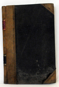
book, Grove, Carl, BUKAN MUNGEE
C.H. Grove spent about 40 years in the area, information is mainly derived from his own recollections and "reliable sources". Charles Henry [Carl] Grove died on 17/4/1938 at Box Hill at the age of 88 and was buried in Orbost. Prior to coming to the Snowy River district, Carl worked as overseer on Buchan Station. In 1880, he selected land at Newmerella after first coming here in 1874 with early selector James A Robertson.He was one of the first selectors at Orbost - in 1880 he selected 320 acres at Newmerella, which he called „Ulinda‟ He married Annie Robertson in 1876. Carl was a farmer, hop and seed grower and nurseryman. He was an elected Councillor of the newly formed Tambo Shire in 1882, and then in 1892 to the Orbost Shire where he served for many years filling varioius public roles. In 1911, he shifted to Queensland, but later returned to Victoria and died at Box Hill. (Ref. Nov 2014 Newsletter) This is a useful reference tool.A carbon copy of a typeset manuscript / transcript book entitled "Bukan Mungee" containing historical and geographical information of the area "bounded by the Snowy River in the east, the Tambo river in the west...and with the following leaseholds, Ensay, Gillingall, and Gelantipy on the north, with Kilmore and Corringle stations on the south..."grove-carl bukan-mungee corringle newmerella snowy-river tambo-river -
 Orbost & District Historical Society
ledger, POUND KEEPERS BOOK ORBOST COUNCIL, mid 20th century
This ledger was used by the Shire of Orbost pound keeper from 15 june 1947 -12 June 1971. The item was donated to Orbost & District Historical society from P.R.O.V. as a Place of Deposit (POD) item for safe keeping by a local history group or museum. The shire covered an area of 9,347 square kilometres and existed from 1892 until 1994 when it became part of the East Gippsland Shire Council. Orbost was at first included in the Bairnsdale Shire from 1882 and was later part of the Tambo Shire. Because of travelling distances the Croajingalong Shire was created in 1892 (name changed to Orbost Shire 17.2.1893 with James Cameron as the first Shire President. In 1994 it amalgamated to become part of East Gippsland Shire Council. This book records the impounding of animals which have been found wandering on local roads or trespassing on land. Many are farm animals. Impounded animals were either claimed by their owners after payment of a fee or if unclaimed , they were sold. The Orbost Pound was situated on Martin Street.This book is a record of a practice which was necessary to remove stock which were wandering on local roads or trespassing on neighbours. It contains many local names and is of social interest. (ref. Vic. Collections)A rectangular hard cover leather bound ledger with fawn cloth spine, titled "POUND KEEPERS BOOK SHIRE OF ORBOST". Inside the back cover are several sales dockets and Shire of Orbost By-Law No 48. Pages are lined in blue and red and pages are headed in black . Entries are hand written in blue and black. The entries give particulars of the animal impounded and where found with name of council officer and owner, if known.orbost-pound orbost-shire-council -
 Orbost & District Historical Society
cash book, 1905 - 1914
This ledger was used by the Shire of Orbost pound keeper from 1906 - 1914. The item was donated to Orbost & District Historical society from P.R.O.V. as a Place of Deposit (POD) item for safe keeping by a local history group or museum. The shire covered an area of 9,347 square kilometres and existed from 1892 until 1994 when it became part of the East Gippsland Shire Council. Orbost was at first included in the Bairnsdale Shire from 1882 and was later part of the Tambo Shire. Because of travelling distances the Croajingalong Shire was created in 1892 (name changed to Orbost Shire 17.2.1893 with James Cameron as the first Shire President. In 1994 it amalgamated to become part of East Gippsland Shire Council. This book records the impounding of animals which have been found wandering on local roads or trespassing on land. Many are farm animals. Impounded animals were either claimed by their owners after payment of a fee or if unclaimed , they were sold. The Orbost Pound was situated on Martin Street.This book is a record of a practice which was necessary to remove stock which were wandering on local roads or trespassing on neighbours. It contains many local names and is of social interest. (ref. Vic. Collections)A ledger with a black cover, brown binding. The page edges are marbled. It contains hand-written records of payments received by the treasurer of the Orbost Pound.on spine : inside a red box in gold lettering"Pound Cash Book" inside a black box in gold lettering"Shire of Orbost"orbost-shire-council orbost-pound accounts cash-book -
 Orbost & District Historical Society
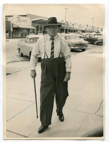
Photograph - Photograph off Albert Trewin
Albert (Abby) Trewin (b.21.03.1876 d. 01.07.1970) was part of the Trewin family who were early settlers at Jarrahmond near Orbost. Albert was born at Kingston near Ballarat, shifted to Jarrahmond where the house was called "Hillview", located 3 miles from Orbost on the B Road. The Trewin selection at Jarrahmond had many big trees on it and because these looked a bit like Jarrah trees from Western Australia, they names their property Jarrahmond (which became the district location and the name of Jarrahmond School). He cleared the land with bullocks, horses, crosscut saws, burned the stumps, burying some logs which were too big to burn. Then they milked cows, planted maize, had pigs, drove the pigs to Bairnsdale or to Waygara (c. 1915 when the train reached Waygara) on a buggy track through the bush. Pigs went to Dandenong Bacon Factory where they were processed into Dandy Ham. This photograph appears to be c.1950s - 1960s.A photograph of one of Jarrahmond's earliest settlers.B/W photograph of a man walking along a footpath. He is wearing a hat and has a walking stick in his right hand. He is wearing braces, white long-sleeved shirt, striped tie, glasses, polished black shoes. Behind him are vehicles and buildings (shops). jarrahmond, farming -
Glen Eira Historical Society
Document - Lempriere Family
Five items about the Lempriere family: 1/Two pages of handwritten (unsigned and undated) research noting their land holdings, taken from the rate books over period 1858-1892. It shows us that John Thompson Lempriere was also Mayor in 1903. 2/Two pages of handwritten (unsigned and undated) notes about Thomas Henry Lempriere and William Geo Lempriere. 3/Photocopied photograph of 'Greenmeadows' on Lemprieres' cow paddock – undated and unknown. 4/Copy of article written by Michael Collins Perse from The Sydney Morning Herald 12/01/2009 on Michael Raoul Lempriere, 'Wool Industry Leader', 11/11/1936-01/10/2008, a descendant of Caulfield's Lempriere family. The article gives a short history of the family involvement in the wool industry. A short family tree history and more about Michael's early life and then his own family and business life. 5/A reprinted family tree from the Australian Dictionary of Biography for the Lempriere family by Justin J Corfield.lempriere thomas h., greenmeadows house, lempriere james, balaclava road, lempriere t.e., hotham street, lempriere john thompson, inkerman street, lempriere carlotta, lempriere mary, lempriere estele, lempriere jane, orrong road, lempriere william, george lempriere, monteiro d’almedin charles charles, stables, outbuildings, graziers, mansions, caulfield common school, committees of management, st marys, blake & riggall solicitors, ratebooks, greenmeadows, cow paddocks, lempriere michael raoul, lempriere bros, lempriere pty. ltd., lempriere peter, lempriere rozel, lempriere william henry, lempriere kathleen, lempriere audley raoul, sportspeople, greene adelaide, lempriere geoffrey, dougall diana, lempriere william, lempriere ben, australian council of wool buyers, federation of australian wool organisations, lempriere lisa, lempriere kristine, persse michael collins -
 Federation University Historical Collection
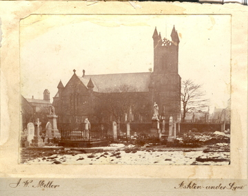
Photo, J.W. Mellor, Holy Trinity, Bardsley and St Michael's and All Angels Church and Cemetery, Ashton-under-Lyne
The Church of St Michael and All Angels dates from the 15th century and is the Parish Church for Ashton under Lyne. It is believed there was a church on this site before the Norman Conquest as the Domesday Book mentions a St Michael's Church in the east of the ancient parish of Manchester. Much of the structure was re-constructed in Victorian times. The church with large windows in Perpendicular style. Buttresses were required with this type of building as the large window area reduced the strength of the walls. The church boasts boasts some of the best examples of fifteenth century stained glass left in Britain. There are eighteen panels illustrating the life of St. Helena. The church tower is 145 feet high and has a peel of thirteen bells. (From ashton-under-lyne.com) Holy Trinity Church, Bardsley was consecrated on the 10th October 1844 by the Bishop of Chester. The church was only the third church in the Borough of Ashton-under-Lyne to be carved out of the parish of St. Michael & All Angels, Ashton. The church was built on land donated by the Hulme Trustees..1) Sepia photograph mounted onto card showing Holy Trinity, Bardsley, Ashton-under-Lyne. Snow is evident in the foreground and the church is surrounded by a graveyard. .2) Sepia photograph mounted onto card showing St Michael's and All Angels church, alongside a graveyard.Signed lower LHS "J.W. Mellor" Lower RHS "Ashton-under-Lyne"cemetery, st michael s and all angels, ashton under lyne, j w mellor, tombstone, tomb stone, headstone, head stone, holy trinity church, bardsley -
 Federation University Historical Collection
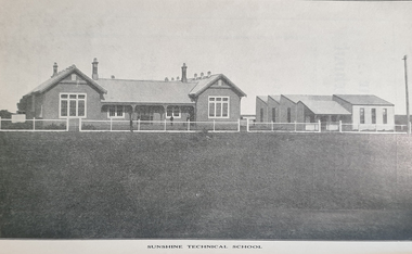
Booklet - Booklet - Prospectus, Exchange Press Pty Ltd, Sunshine Technical School, Prospectus, 1914, 1914
Used at School of mines and industries Ballarat As H.V. McKay's Sunshine Harvester business expanded there was a requirement for a school to train the company's apprentices. In 1911, H.V. McKay wrote to the Victoria Cabinet offering 2,000 pounds and 4 1/2 acres of land in Derby Rd for a technical school, On the 7th July 1913, the new Sunshine Technical School opened with a wooded administration building with six class rooms and a large galvanised iron workshop for the trade apprentices. Mr George Baxter was appointed principal with assistant teachers, A.J. Dunlop (Maths & English), W.W. Anderson (Art) & H.B. Ernest (Maths & Science). Seventy students were enrolled in the first year of which 44 were apprentices from the Harvester Works. During the First World War Years (1914 - 1918) there was a difficulties with staffing and enrollments. The school was also used to provide vocational training for wounded returned soldiers. In 1919 during the great influenza epidemic the school was used as a hospital. Light blue soft covered booklet of 60 pages with information about office bearers, staff, objects of the school, prizes and scholarships, examinations, time tables, courses, and subjects. It has photographs and advertising.sunshine, technical school, sunshine technical school, prospectus, hugh victor mckay, r.m. lambert, george mckay, d.b. ferguson, samuel mckay, george bult, ralph mckay, george butlin, george baxter, f.s. midgley, j.b. gray, w. kerr, a.j. dunlop, h. ernst, w.w. anderson, f. cleary, school councillors, staff, blacksmithing, carpentry, fitting and turning, moulding, sheet metal, mathematis, english, science, art, 1914, h v mckay, sunshine harvester, 2000 pounds and land donated, wounded returned soldiers, 1919 ued as hospital, influenza epidemic -
 City of Moorabbin Historical Society (Operating the Box Cottage Museum)
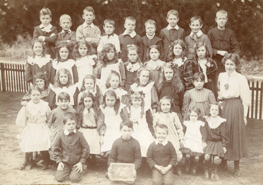
Photograph, Black & White West Beaumaris (Cheltenham) State School Grade 3 1908, 1908
Stephen Charman, 1821-1906 a market gardener, donated land for the first Methodist Chapel, Cemetery and School in Charman Rd Cheltenham 1855. The enrolment was 36 pupils with Mr Frederick Meeres as Teacher. 1863 the school is called Beaumaris Common School No 84 with 70 pupils and Walter Meeres as Teacher. 1869 another 2 acres in Charman Road were granted by the Education Board and brick building built . 1872 State School 84 Beaumaris was increasing enrolments and 1878 a new brick school was built to accommodate 174 pupils and the name changed to Cheltenham State School No.84 1894 Mentone State School No.2950 amalgamated with Cheltenham SS No.84. 1910 the buildings were in disrepair, overcrowding was increasing and renovations were made 1912 with further additions in 1925 and 1937. Post WW11 extra prefabricated Classrooms were added as enrolment increased to 1038 in 1955.. Cheltenham East State School 4754 was opened as housing development spread over the City of Moorabbin . (J.Larson Sandringham HS) 1855 Stephen Charman donated land to the Methodist Church so that a School could be established to educate the children of the early settler market gardeners and farmers in the Cheltenham area . Education was valued by the general community and as well as schools they established mechanics Institutes and Libraries in Moorabbin Shire. Cheltenham State School No. 84 was among the first schools in MelbourneBlack & White photograph of Class 3 pupils at West Beaumaris (Cheltenham )State School 1908Front Handwritten - B.Wooff ---- T.Moodie,- R.Whelan - / 1908 Back Handwritten - Beaumaris, / Mrs White / Mrs Taylorcity of moorabbin, county of bourke, moorabbin roads board, parish of moorabbin, shire of moorabbin, henry dendy's special survey 1841, were j.b., bent thomas, o'shannassy john, king richard, charman stephen, highett william, ormond francis, maynard dennis, cheltenham state school no.84, methodist chapel cheltenham, methodist school cheltenham, beaumaris west state school, meeres frederick, meeres walter, education, early settlers, cancel -
 City of Moorabbin Historical Society (Operating the Box Cottage Museum)
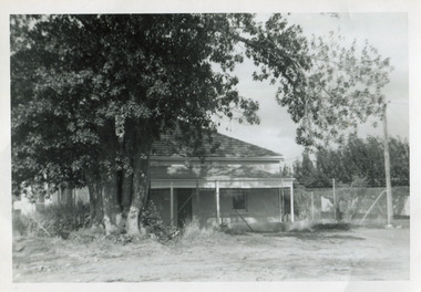
Photograph, Black & White Gulliver's House, Marian Lodge, Methodist Childrens Home Cheltemham, c1935
The Methodist Children's Home was originally the home of Mr Gulliver a chemist. It became the centre of a farm at the Home. When the Home was sold to the Catholic Church 1953 it was renamed 'Marian Lodge'. The Methodist Children's Home in Cheltenham was founded c1880 to provide housing for neglected children from the inner city. The Founders aimed to provide regular nourishment, a stable environment and integrate the children into the local community thereby improving their education and lives. However new settlers to Cheltenham area who were seeking a healthier and more respectable lifestyle for their families were not happy to share Church and School with the Home's Children. ( see 00561) 1950's saw a new direction for the support of children and families in poor and difficult situations . The new Methodist Burwood Homes Facility opened in 1951 and children were transferred from Cheltenham in 1952. The land was sold to the St John of God, Catholic Order in1953 who maintained an orphanage until Myer Pty Ltd bought the site in 1967 and constructed the Southland Shopping Centre c1892-1953 The Methodist Children's Home Cheltenham was founded to provide safe accommodation and education for neglected children from the inner city slums. The St John of God Order purchased the Home 1953 and the land was sold to Myer Pty Ltd. who built Southland Shopping Centre 1967 Black & White photograph showing a farm house that was originally owned by Mr Gulliver, a chemist and then the Methodist Children's Home was established 1892. Named Marian Lodge after the St John of God Catholic Order purchased the property in 1953 Back Hand written information st john of god home cheltenham 1953-1967, marian lodge, mr gulliver, pharmacy, methodist childrens home cheltenham 1892-1953, myer southland 1967, city of moorabbin, county of bourke, moorabbin roads board, parish of moorabbin, shire of moorabbin, henry dendy's special survey 1841, were j.b.; bent thomas, o'shannassy john, king richard, charman stephen, highett william, ormond francis, maynard dennis, cheltenham state school no.84, methodist chapel cheltenham, methodist school cheltenham, beaumaris west state school, meeres frederick, meeres walter, education, early settlers, -
 City of Moorabbin Historical Society (Operating the Box Cottage Museum)
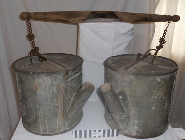
Tool - Chinese Market-Gardener's Watering-Cans
Chinese market-gardener’s watering-cans on a wooden yoke. This item was authenticated by the Bendigo Historical Society, and is said to be quite rare. It consists of two large galvanized watering-cans each with a pouring spout, suspended by chains from a well-used wooden yoke. The cans would each have been filled with water, then carried a distance into the market garden and used to water crops. The cans and yoke alone are very heavy, one can only imagine how heavy they were when filled with water.As profits from the gold-fields petered out the Chinese immigrants, (nearly all single men), were forced to seek other occupations. Many moved into furniture building in the East Melbourne area, whilst others went into market gardening . A significant number of Chinese men, realising the potential of the sandy, fertile soil, with a good supply of water, in the Shire of Moorabbin, leased tracts of land in that area to establish a market garden and grow produce for the increasing population of MelbourneAfter the Dendy Special Survey in1841in Brighton, Victoria, the first sale of Crown Land, taking in the whole Shire of Moorabbin, occurred in 1852. These allotments of land were eagerly bought up - some by speculators - although many were either worked by the owner, or leased out as market gardens and "fruit gardens", (orchards). Chinese market-gardener’s watering-cans suspended by chains on a wooden yoke. This item was authenticated by the Bendigo Historical Society, and is said to be quite rare. It consists of two large galvanized watering-cans each with a pouring spout, suspended by chains from a well-used wooden yokebrighton, gardeners, bentleigh, orchards, vegetables, dendy henry, market gardens, chinese settlers, pioneers moorabbin, water wells, creeks -
 Dutch Australian Heritage Centre Victoria
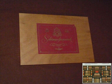
Cigar Box
The Schimmelpenninck factory stood in Wageningen until it finally closed in 2000. The Schimmelpenninck brand started in 1924 when two brothers and an uncle merged their cigar factories into one company. It was called after Rutger Jan Schimmelpenninck, raadspensionaris (kind of a prime minister) of the Batavian Republic in 1805-1806. The tobacco industry has a long history in this town; in the 17th century one fifth of all arable land around the town was used for tobacco. Originally used in pipes and as snuff, the popularity of cigars in the 19th century led to a large expansion of the Dutch tobacco industry. The Schimmelpenninck factory was at its largest just before World war II, 700 employees produced 32 million cigars. Wageningen was heavily damaged during operation Market Garden in 1944, the whole population was evacuated and most of the machines of the Schimmelpenninck factory were stolen or destroyed. After the war, consumption of cigars was much reduced and the firm slowly merged with others. Eventually they became part of Rothmans.This box and the brand name Schimmelpenninck represent several periods of Dutch history between the time of the Republic and the post WWII years. Cigar smoking was very popular in the Netherlands pre-war but less so in the second half of the 20th century partly due to a growing awareness of tobacco's carciogenic properties.Large flat wooden box designed to hold 78 cigars. The lid is attached with brass hinges and two brass clasps enable it to be closed. A large red label with silver script and illustrations is attached to both the outside and the inside of the lid.Schimmelpenninck. Hollands Finest Cigars -
 St Kilda Historical Society
Photograph, 26/11/1978
Image taken on a bus trip, 26 November 1978. Christ Church was constructed in 1854-57 and designed in Decorated Gothic style by Albert Purchase & Charles Swyer. It was enlarged in 1874 and 1881 to the designs of Sydney W Smith. It is one of four main buildings constructed on land granted to the Church of England in 1855 and named Church Square. The other buildings are the bishop's residence, vicarage and parish hall. Heritage Victoria describes it as a 'rare and significant square in the history of town planning in Victoria which demonstrates the importance of the church to the community'. It is built from rarely used undressed random coursed sandstone from Point King Sorrento. It is located at 14 Acland Street, St Kilda. The triangular rose window is said to have been modelled on Lichfield Cathedral and shows outstanding craftsmanship. According to Heritage Victoria, the only other known example in Victoria is at St Georges Presbyterian Church in East St Kilda, designed by the same architect, Albert Purchas.colour photograph polaroidSKHS Bus trip 26/11/78 Christ Churchrose window, acland street, purchase, swyer, st kilda, christ church, churches -
 National Wool Museum
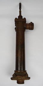
Tool - Water Pump, c.1960
A windmill may be considered one of the most iconic sights of Australian Farming life. A pump like this rest at the heart of all such windmills, turning wind energy into water for farmers both here in Australia and worldwide alike. The water windmills access is referred to as an aquifer, an underground layer of water trapped in rocks but accessible with use of water wells and windmills. Australia is home to an underground aquifer known as the Great Artesian Basin. It is the largest and deepest aquifer in the world. Stretching over 1,700,000 square kilometres, the Basin underlies nearly a quarter of the continent including most of Queensland, the south- east corner of the Northern Territory, the north-east part of South Australia and the northern part of New South Wales. The basin is 3,000 metres deep in places and is estimated to contain 64,900 cubic kilometres of groundwater. To try and give this number context, a megalitre is a million litres. The Great Artesian Basin contains 65,000 million megalitres of water. This would be enough to cover all the land on the planet in almost half a metre of water.Lift style piston pump typical of an Australian farm connected to a multi-bladed windmill. Bronze cylindrical construction coming up from removable wood base. Rotating lever is above outlet pipe which would send water to the storage tank.windmill, australian farming, great artesian basin, aquifer -
 Ballarat Heritage Services
Photograph - Photograph - Black and White, Ballarat Celebrations 1937, 1937
Bank on the north west corner of Sturt and Lydiard Streets. I suspect that these are photographs before the celebrations for the coronation. See The Argus 13 May 1937 "Celebrations in Many Country Towns" Ballarat Celebrations BALLARAT Wednesday - Special Coronation celebrations were largely attended In the morning there was a service In Christ Church, at which representatlves of the council and other public bodies were present There was a similar gathering in St Andrew's Kirk At a civic service in the Alfred Hall in the afternoon the address was given by the Bishop of Ballarat (the Right Rev W Johnson). Bishop Johnson spoke of the personal association of King George V with his people, and said that the present King and Queen would be equally concerned with the welfare of their subjects The Revs H A Horsfall and B E Williams co-operated In the service, which was presided over by the Mayor (Councillor J Pryor) Mr Lloyd Lindsay recited Mase?Coronation ode and Miss W Ritchie sang "Land of Hope and Glory ' At night a Coronation concert was held in the Alfred HallSmall black and white photographB 249 on versomax walters, ballarat, 1937, celebrations, bank, sturt street, lydiard street, anniversary -
 Kew Historical Society Inc
Plan - Subdivision Plan, J R Mathers & McMillan, Plan of Subdivision of Part of Crown Portion 83 at Kew : LP6669, 1923-1939
In 1888, in the section of Park Hill Road between Belmont Avenue and Normanby Road there was only one street running between Park Hill Road and Cotham Road. This was Park Road, later to be named Adeney Avenue. Subsequent 20th century subdivisions created the ‘through roads’ of Cecil Street, Wimba Avenue, Florence Avenue, Marshall Avenue, Uvadale Road, and Barrington Avenue. This subdivision represents an attempt by auctioneers, rather than town planners to create an urban environment from larger residential allotments or in many cases farmland. Existing streets such as Parkhill and Normanby Roads provided a convenient starting point for the surveyors, but the Road named ‘Street Street’ indicates the role of the private surveyor in creating streets. Given that a number of allotments are listed as sold on the plan, the street is presumably Cecil Street. Even those lots that had been sold do not quite match the dimensions of the blocks in this parcel of land today, indicating that either further subdivisions or boundary alterations occurred.Subdivision plans are historically important documents used as evidence for the growth of suburbs in Australia. They frequently provide information about when the land was sold as well as evidence relating to surveyors and real estate and financial agents. The numerous subdivision plans in the Kew Historical Society's collection represent working documents, ranging from the initial sketches made in planning a subdivision to printed plans on which auctioneers or agents listed the prices for which individual lots were sold. In a number of cases, the reverse of a subdivision plan in the collection includes a photograph of a house that was also for sale by the agent. These photographs provide significant heritage information relating house design and decoration, fencing and household gardens.The photograph may also be aesthetically significant depending on the importance of the photographic atelier.Hand-drawn subdivision plan of 19 lots facing Parkhill Road, Normanby Road, and an unnamed street [now Cecil Street] in Kew.Estate Agent notes in ink indicate those lots which had sold.subdivision plans - kew, parkhill road - kew, cecil street - kew, normanby road - kew, cecil street -kew, parkhill road - kew, normanby road - kew, crown portion 83 - kew -
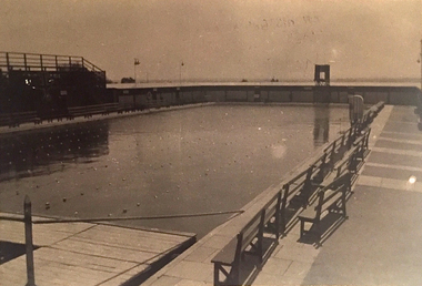
 Kew Historical Society Inc
Photograph, Kew Municipal Baths, 1929-1933
W.D. Vaughan in 'Kew's Civic Century' (1960) has a chapter (XXII, pp.103-105) on the Kew Swimming Pool (aka Kew Baths). In the chapter he recounts debate in Council from 1912 about the need for a swimming pool. The first concrete step toward achieving this occurred in 1914 when Council purchased the Tramways Sheds on the corner of High and Disraeli Streets in 1914. Further adjoining land in High Street was compulsorily acquired in 1923. The final plans were accepted in 1925 and following public tender, Messrs. Weavill and Keast were appointed to construct the pool at a cost of 5,418/9/-. The baths were formally opened on 18 November 1925 by George Ramsay, Mayor of Kew. (The Kew Swimming Club was founded in the same year.) Vaughan notes that "mixed bathing was not permitted at the Kew Baths until January, 1928, when it was allowed every evening (except Sundays) and Friday afternoons. A few years later these restrictions were removed altogether".Small B&W photograph of a crowd of onlookers watching swimming events in the old Kew Swimming Pool in High Street. The photograph can be dated to the years 1929-33, as the wooden grandstand was not erected until 1929 and it was before a new high swimming platform was erected in 1933."Old Swimming Pool. D1. 92"kew swimming pool - kew (vic), sport and recreation - kew (vic), kew baths - kew (vic), mayors of kew - cr. george ramsay - kew (vic), kew swimming club -
 Kew Historical Society Inc
Photograph, Kew Municipal Baths, 1929-1933
W.D. Vaughan in 'Kew's Civic Century' (1960) has a chapter (XXII, pp.103-105) on the Kew Swimming Pool (aka Kew Baths). In the chapter he recounts debate in Council from 1912 about the need for a swimming pool. The first concrete step toward achieving this occurred in 1914 when Council purchased the Tramways Sheds on the corner of High and Disraeli Streets in 1914. Further adjoining land in High Street was compulsorily acquired in 1923. The final plans were accepted in 1925 and following public tender, Messrs. Weavill and Keast were appointed to construct the pool at a cost of 5,418/9/-. The baths were formally opened on 18 November 1925 by George Ramsay, Mayor of Kew. (The Kew Swimming Club was founded in the same year.) Vaughan notes that "mixed bathing was not permitted at the Kew Baths until January, 1928, when it was allowed every evening (except Sundays) and Friday afternoons. A few years later these restrictions were removed altogether".Small B&W photograph of the old Kew Swimming Pool showing seating at right. The photograph can be dated to the years 1929-33, as the wooden grandstand was not erected until 1929 and it was before a new high swimming platform was erected in 1933."D3. 92"kew swimming pool - kew (vic), sport and recreation - kew (vic), kew baths - kew (vic), mayors of kew - cr. george ramsay - kew (vic), kew swimming club -
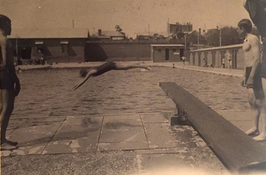 Kew Historical Society Inc
Photograph, Kew Municipal Baths, 1930s
W.D. Vaughan in 'Kew's Civic Century' (1960) has a chapter (XXII, pp.103-105) on the Kew Swimming Pool (aka Kew Baths). In the chapter he recounts debate in Council from 1912 about the need for a swimming pool. The first concrete step toward achieving this occurred in 1914 when Council purchased the Tramways Sheds on the corner of High and Disraeli Streets in 1914. Further adjoining land in High Street was compulsorily acquired in 1923. The final plans were accepted in 1925 and following public tender, Messrs. Weavill and Keast were appointed to construct the pool at a cost of 5,418/9/-. The baths were formally opened on 18 November 1925 by George Ramsay, Mayor of Kew. (The Kew Swimming Club was founded in the same year.) Vaughan notes that "mixed bathing was not permitted at the Kew Baths until January, 1928, when it was allowed every evening (except Sundays) and Friday afternoons. A few years later these restrictions were removed altogether".Small B&W photograph of two boys standing beside a diving board at the old Kew Swimming Pool while in the distance a woman dives into the pool. The photograph can be dated to the years 1929-33, as the wooden grandstand was not erected until 1929 and it was before a new high swimming platform was erected in 1933."Old Swimming Pool Kew. D4. 92"kew swimming pool - kew (vic), sport and recreation - kew (vic), kew baths - kew (vic), mayors of kew - cr. george ramsay - kew (vic), kew swimming club -
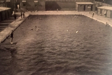 Kew Historical Society Inc
Photograph, Kew Municipal Baths, 1929-1933
W.D. Vaughan in 'Kew's Civic Century' (1960) has a chapter (XXII, pp.103-105) on the Kew Swimming Pool (aka Kew Baths). In the chapter he recounts debate in Council from 1912 about the need for a swimming pool. The first concrete step toward achieving this occurred in 1914 when Council purchased the Tramways Sheds on the corner of High and Disraeli Streets in 1914. Further adjoining land in High Street was compulsorily acquired in 1923. The final plans were accepted in 1925 and following public tender, Messrs. Weavill and Keast were appointed to construct the pool at a cost of 5,418/9/-. The baths were formally opened on 18 November 1925 by George Ramsay, Mayor of Kew. (The Kew Swimming Club was founded in the same year.) Vaughan notes that "mixed bathing was not permitted at the Kew Baths until January, 1928, when it was allowed every evening (except Sundays) and Friday afternoons. A few years later these restrictions were removed altogether".Small B&W photograph of the old Kew Swimming Pool. Girl on diving board at left. The photograph can be dated to the years 1929-33, as the wooden grandstand was not erected until 1929 and it was before a new high swimming platform was erected in 1933."Old Swimming Pool Kew. D2. 92"kew swimming pool - kew (vic), sport and recreation - kew (vic), kew baths - kew (vic), mayors of kew - cr. george ramsay - kew (vic), kew swimming club -
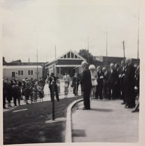 Kew Historical Society Inc
Photograph, Series - Kew Baths & Carmelite Monastery, 1960s
W.D. Vaughan in 'Kew's Civic Century' (1960) has a chapter (XXII, pp.103-105) on the Kew Swimming Pool (aka Kew Baths). In the chapter he recounts debate in Council from 1912 about the need for a swimming pool. The first concrete step toward achieving this occurred in 1914 when Council purchased the Tramways Sheds on the corner of High and Disraeli Streets in 1914. Further adjoining land in High Street was compulsorily acquired in 1923. The final plans were accepted in 1925 and following public tender, Messrs. Weavill and Keast were appointed to construct the pool at a cost of 5,418/9/-. The baths were formally opened on 18 November 1925 by George Ramsay, Mayor of Kew. (The Kew Swimming Club was founded in the same year.) Vaughan notes that "mixed bathing was not permitted at the Kew Baths until January, 1928, when it was allowed every evening (except Sundays) and Friday afternoons. A few years later these restrictions were removed altogether".Five black and white photographs of Kew in the 1960s donated by Kerstin Fraser. The photographs include 3 pictures of the Mayor of Kew, Gordon Greer at the Kew Baths and two photographs of the Carmelite Monastery in Stevenson Street, Kew.kew baths - kew (vic), carmelite monastery - stevenson street - kew (vic), cr leo hawkins, swimming -
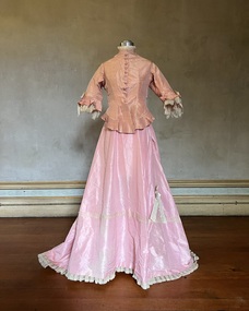 Kew Historical Society Inc
Clothing - Two-piece pink silk afternoon outfit, 1875
This afternoon dress was owned and first worn in 1875 by Alice (Henty) Hindson, the daughter of Francis Henty and Mary Ann (Lawrence) Henty. The outfit was worn in the same year as Alice's marriage to John Hindson at Trinity Church, East Melbourne, and may have formed part of her trousseau. Alice's father, Francis Henty, was the youngest son of Thomas Henty, who with his family, their retainers and property moved to the Australian colonies between 1829 and 1832. In 1834, Francis’ older brother, Edward, sailed from Launceston in Van Diemen’s Land to what was to become Portland in the western part of Port Phillip District [Victoria]. Francis, together with the first flock of Merino sheep [in Victoria], followed some months later. The first and second generations of the Henty family established vast pastoral properties in the Western part of the Port Phillip District. Francis Henty managed ‘Merino Downs’ near Casterton, while also living in his retirement at ‘Field Place' in Kew. The Henty Collection of nineteenth and twentieth century clothing, including outerwear and underwear, was collected, stored and exhibited over time by female family members descended from Francis and Mary Ann Henty. During the twentieth century, items from the collection were modelled in two fashion parades by various descendants [1937, 1959]. The items in the collection are historically and aesthetically significant, with provenance provided by oral and written tradition within or held by the family. A number of the items in the collection are very rare survivors, and provide researchers with the evidence needed to reconstruct the lives of notable women in the Port Phillip District [later Victoria] during the nineteenth and early twentieth century.Alice (Henty) Hindson's afternoon dress is a two-piece, two-toned pink ensemble made of silk taffeta. The detailing is done with fine knife-pleated trims piped in ivory satin and decorated with ivory silk moiré bows on the bodice and skirt. The panelled peplum jacket is boned and the front button closure has hand-embroidered buttonholes with handmade covered buttons. The gathered full buttoned skirt falls into a train. The skirt is decorated with rows of ivory tulle corded lace and the hemline is edged with crisp fluted organza and tatted lace. Measurements (mm): BODICE: Girth - Neck 355.6, Chest 863.6, Waist 685.8, Hip 787.4, Cuff 304.8, Hem circumference 1422.4. Vertical - From neck to hem 546.1, Front waist to hem 241.3, Back neck to hem 609.6, Back waist to hem 355.6, Sleeve length 330.2. Horizontal - Neck to sleeve head 60, Underarm to underarm 419.1. SKIRT Girth - Waist 558.8, Hip 1473.2, Hem circumference 3911.6. Vertical - Front waist to hem 1092.2, Back waist to hem 1524. fashion -- 1870s, afternoon dresses, alice (henty) hindson, women's clothing -
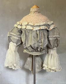 Kew Historical Society Inc
Clothing - Grey silk and lace bodice, 1875
Alice Frances (Henty) Hindson's grey silk bodice is believed to be part of her 'going-away' outfit after her wedding to John Hindson on 15 April 1875. The bodice must have been a family favourite as it was used and amended over the years. Alice was the youngest daughter of Francis Henty and Mary Ann (Lawrence) Henty. Alice's father, Francis Henty, was the youngest son of Thomas Henty, who with his family, their retainers and property moved to the Australian colonies between 1829 and 1832. In 1834, Francis’ older brother, Edward, sailed from Launceston in Van Diemen’s Land to what was to become Portland in the western part of Port Phillip District [Victoria]. Francis, together with the first flock of Merino sheep [in Victoria], followed some months later. The first and second generations of the Henty family established vast pastoral properties in the Western part of the Port Phillip District. Francis Henty managed ‘Merino Downs’ near Casterton, while also living in his retirement at ‘Field Place' in Kew. The Henty Collection of nineteenth and twentieth century clothing, including outerwear and underwear, was collected, stored and exhibited over time by female family members descended from Francis and Mary Ann Henty. During the twentieth century, items from the collection were modelled in two fashion parades by various descendants [1937, 1959]. The items in the collection are historically and aesthetically significant, with provenance provided by oral and written tradition within or held by the family. A number of the items in the collection are very rare survivors, and provide researchers with the evidence needed to reconstruct the lives of notable women in the Port Phillip District [later Victoria] during the nineteenth and early twentieth century.The yoke is a bustier bodice, made of silk and silk organza with an insert of hand-tatted lace. The bodice is carefully boned and has a little padding in the bust line. It includes the name of the maker of the bodice as ‘Madame Jay, Brighton, 38 London Road’. The silk organza sleeves have hand shirring, trim, and frilled cuffs. The bodice is finished with a large, frilled bow at the back. Believed by the Henty family to be part of the ‘going away’ outfit worn by Alice Henty in 1875. Measurements (mm): BODICE: Girth - Neck 304.8, Chest 762, Waist 571.5, Cuff 127 Vertical - From neck to hem 381, Front waist to hem 152.4, Back neck to hem 419.1, Back waist to hem 228.6, Sleeve length 254. Horizontal - Neck to sleeve head 165.1, Cross back 457.2, Underarm to underarm 431.8.Mme Jay, Brighton Road, London [dressmaker]bodices, women's clothing, alice (henty) hindson, alice francés henty -
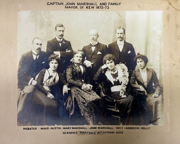 Kew Historical Society Inc
Photograph - Family Portrait, Captain John Marshall and Family, Mayor of Kew 1872-73, 1890s
Captain John Marshall was born in Dundee, Scotland c.1833. Within eleven years of his arrival in Melbourne in 1852, he had established an important colonial shipping company, Anderson & Marshall, and married Mary Austin, the eldest daughter of Thomas Austin Esq of Clifton Villa in Cotham Road. Elected to the Kew Borough Council in 1869, he remained an active member until 1875. During this period, he was elected Mayor of Kew in 1872. A Scottish Protestant by birth and conviction, John Marshall was, with David Beath, a member of the inaugural committee that began planning for a separate Presbyterian Church in Kew, lending the Committee the funds to purchase land on the corner of Cotham Road and Highbury Grove. John Marshall lived at his home, 'Maryfield', at what was then 239 [now 197] Cotham Road until shortly before his death at the age of 70 in January 1903. He was buried on 14 January in Grave 493, Presbyterian Compartment A, Boroondara General Cemetery.Family portrait of an important civic figure in Kew in the 19th century who was also a notable businessman and shipowner in the Colony of Victoria.Albumen Silver photograph on card of Captain John Marshall and family, Mayor of Kew 1872-73.The inscription was added by the family and at one stage modified. In addition to the title, the sitters' names are inscribed beneath the photograph on the mountCaptain John Marshall and family / Mayor of Kew 1872-73 Webster - Maud - Austin - Mary Marshall - John Marshall - May - Andrew - Polly / Residence “Maryvale” 197 Cotham Road. john marshall, maryvale (cotham road, kew), maryfield (cotham road, kew), webster marshall, maud marshall, austin marshall, mary marshall, may marshall, andrew marshall, polly marshall -
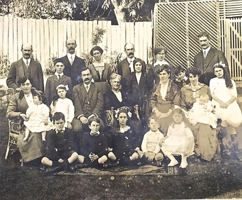 Kew Historical Society Inc
Photograph - Family portrait, The Marshall Family, 1903-1914
Captain John Marshall was born in Dundee, Scotland c.1833. Within eleven years of his arrival in Melbourne in 1852, he had established an important colonial shipping company, Anderson & Marshall, and married Mary Austin, the eldest daughter of Thomas Austin Esq of Clifton Villa in Cotham Road. Elected to the Kew Borough Council in 1869, he remained an active member until 1875. During this period, he was elected Mayor of Kew in 1872. A Scottish Protestant by birth and conviction, John Marshall was, with David Beath, a member of the inaugural committee that began planning for a separate Presbyterian Church in Kew, lending the Committee the funds to purchase land on the corner of Cotham Road and Highbury Grove. John Marshall lived at his home, 'Maryfield', at what was then 239 [now 197] Cotham Road until shortly before his death at the age of 70 in January 1903. He was buried on 14 January in Grave 493, Presbyterian Compartment A, Boroondara General Cemetery.Family portrait of the relatives of an important civic figure in Kew in the 19th century who was also a notable businessman and shipowner in the Colony of Victoria.Albumen silver photograph on card of the Marshall family grouped in three rows in a garden setting. The twenty-three members of the extended family do not include John Marshall so the photograph presumably dates from after his death in 1903. His wife, Mary Marshall, is in the middle row, five from left. marshall family, john marshall -- mayor of kew -
 Kew Historical Society Inc
Photograph - 'Butleigh Wooton', 867 Glenferrie Road, John T Collins, 1979
in 1882 Thomas Maidment paid the Society of Jesus £5,750 for nine allotments along Barkly Road (now Glenferrie Road). Maidment, who had arrived in Australia from the Glastonbury district in England in 1858, owned and managed a number of sheep stations in Victoria and subsequently became an '... eminently respectable ...' member of District society. In 1883 the Rate Books list Maidment's land in Barkly Road as the 'Buxton Hill Estate' and it was given an N.A.V. of £90, while in the following year his property attracted an N.A.V. of £160, suggesting that substantial improvements were taking place. Maidment's two-storey mansion, named 'Butleigh Wooton' after his birth-place in England, was completed in 1885 and was given an initial N.A.V. of £420. While Maidrnent is recorded as the owner of the building until at least 1896, Jane Maidment, his wife, continued the family ownership of the twenty-six roomed house with its extensive grounds until at least 1910. (Sanderson P. City of Kew Urban Conservation Study Vol 2)Butleigh Wooton is a substantial two storeyed house built in the Italianate style common in the 1880s. Its walls are rendered and it has limited applied decoration that includes brackets to the eaves line and engaged ionic columns under a broken pediment over the front entrance. The bowed window unit is of particular distinction and is not at all typical of this type of building. This interior by John T Collins is a view of the staircase from the first floor landing. (Sanderson P. City of Kew Urban Conservation Study Vol 2)Reverse: "JOHN COLLINS / 11 Anderson Road / Hawthorn East, 3123 / Film 395 Exposure 27A / Kew / Butleigh Wooton / Looking down on stairs / 8-4-79thomas maidment, butleigh wooton, 867 glenferrie road -- kew (vic.) -
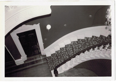
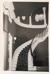 Kew Historical Society Inc
Photograph - 'Butleigh Wooton', 867 Glenferrie Road, John T Collins, 1979
in 1882 Thomas Maidment paid the Society of Jesus £5,750 for nine allotments along Barkly Road (now Glenferrie Road). Maidment, who had arrived in Australia from the Glastonbury district in England in 1858, owned and managed a number of sheep stations in Victoria and subsequently became an '... eminently respectable ...' member of District society. In 1883 the Rate Books list Maidment's land in Barkly Road as the 'Buxton Hill Estate' and it was given an N.A.V. of £90, while in the following year his property attracted an N.A.V. of £160, suggesting that substantial improvements were taking place. Maidment's two-storey mansion, named 'Butleigh Wooton' after his birth-place in England, was completed in 1885 and was given an initial N.A.V. of £420. While Maidrnent is recorded as the owner of the building until at least 1896, Jane Maidment, his wife, continued the family ownership of the twenty-six roomed house with its extensive grounds until at least 1910. (Sanderson P. City of Kew Urban Conservation Study Vol 2)Butleigh Wooton is a substantial two storeyed house built in the Italianate style common in the 1880s. Its walls are rendered and it has limited applied decoration that includes brackets to the eaves line and engaged ionic columns under a broken pediment over the front entrance. The bowed window unit is of particular distinction and is not at all typical of this type of building. This interior by John T Collins is a view of the staircase from the first floor landing. (Sanderson P. City of Kew Urban Conservation Study Vol 2)Reverse: "JOHN COLLINS / 11 Anderson Road / Hawthorn East, 3123 / Film 395 Exposure 21A / Kew / Butleigh Wooton / Staircase / 8-4-79thomas maidment, butleigh wooton, 867 glenferrie road -- kew (vic.), john t collins -
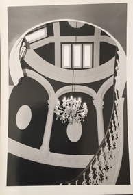 Kew Historical Society Inc
Photograph - 'Butleigh Wooton', 867 Glenferrie Road, John T Collins, 1979
in 1882 Thomas Maidment paid the Society of Jesus £5,750 for nine allotments along Barkly Road (now Glenferrie Road). Maidment, who had arrived in Australia from the Glastonbury district in England in 1858, owned and managed a number of sheep stations in Victoria and subsequently became an '... eminently respectable ...' member of District society. In 1883 the Rate Books list Maidment's land in Barkly Road as the 'Buxton Hill Estate' and it was given an N.A.V. of £90, while in the following year his property attracted an N.A.V. of £160, suggesting that substantial improvements were taking place. Maidment's two-storey mansion, named 'Butleigh Wooton' after his birth-place in England, was completed in 1885 and was given an initial N.A.V. of £420. While Maidrnent is recorded as the owner of the building until at least 1896, Jane Maidment, his wife, continued the family ownership of the twenty-six roomed house with its extensive grounds until at least 1910. (Sanderson P. City of Kew Urban Conservation Study Vol 2)Butleigh Wooton is a substantial two storeyed house built in the Italianate style common in the 1880s. Its walls are rendered and it has limited applied decoration that includes brackets to the eaves line and engaged ionic columns under a broken pediment over the front entrance. The bowed window unit is of particular distinction and is not at all typical of this type of building. This interior by John T Collins is a view of the staircase from the first floor landing. (Sanderson P. City of Kew Urban Conservation Study Vol 2)Reverse: "JOHN COLLINS / 11 Anderson Road / Hawthorn East, 3123 / Film 395 Exposure 21A / Kew / Butleigh Wooton / Staircase looking up to dome / 8-4-79thomas maidment, butleigh wooton, 867 glenferrie road -- kew (vic.), john t collins