Showing 126749 items
matching main-road
-
 Eltham District Historical Society Inc
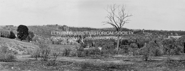
Photograph, Barry Philp, Looking north from the top of the hill near Reynolds Road, Research, c.1969
Taken from the top of the hill near Reynolds road looking north. The footy ground is visible behind the dead tree.research (vic.), research oval, reynolds road -
 Greensborough Historical Society
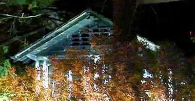
Photograph - Digital Image, 113 Mountainview Road Briar Hill, 2018 - post-fire, 14/07/2018
Photographs of house and car at 113 Mountainview Road Briar Hill, taken after the house was destroyed by fire in July 2018.Digital images of 2 colour photographs.mountainview road briar hill, house fire -
 Greensborough Historical Society
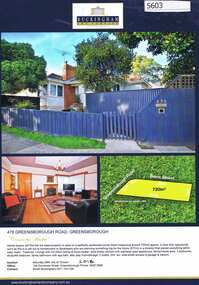
Advertising Leaflet, 478 Greensborough Road, Greensborough, 28/07/2014
478 Greensborough Road, Greensborough. 3 bedroom home, auctioned 28 July 2014, sold August 2014 for $580,000Real estate advertising leaflet, one sheet, printed in colour on one sidegreensborough road greensborough -
 Greensborough Historical Society
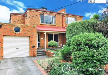
Advertising Leaflet, 17 Dobson Road Montmorency, 14/05/2012
17 Dobson Road Montmorency. 4 bedroom, 2 storey home, private sale, sold March 2012 for $460,099Real estate advertising leaflet, 1 sheet, printed in colour both sidesdobson road montmorency -
 Greensborough Historical Society
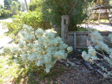
Photograph - Digital image, Old Post, Mountainview Road, 02/05/2013
Photograph of old hitching post located in Mountainview Road Briar Hill. The post is located in the front garden of a residential block.Digital copy of colour photograph.mountainview road -
 Bialik College
Documents, Construction of building on the Auburn Road campus, c. 1980s, 1980s
Plans for the construction of a building on the Auburn Road campus, c. 1980s. Please contact [email protected] to request access to this record.development -
 Surrey Hills Historical Society Collection
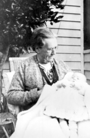
Photograph, Mrs Alice Sedgman of 65 Croydon Road, Surrey Hills
Alice Sedgman (nee Percy) – 1873-1945 Alice was born in Maldon in 1873, one of 9 children of William Henry Percy and his wife Unice King. Alice married Francis Sedgman, occupation painter, in 1896 and they went on to have 8 children, all born in Kew or Hawthorn before the family came to Surrey Hills. The electoral roll for 1903 shows the family living in Liddiard Street in Hawthorn and Alice’s occupation is given as home duties. It is the same in 1909 when they are living at 65 Croydon Road, Surrey Hills and continues to be thus listed in all electoral rolls until the 1943 edition, just before her death. However Mrs Sedgman was also an active nurse and midwife who often worked with Dr James Blakie, who had arrived in Surrey Hills in 1905, initially practicing from 171 Union Road and then in 1913 moving across the road to the purpose-built home and practice at 174 Union Road, now Surrey Hills Medical Centre. At this period most babies were born at home. Sometime after 1931 Alice and Francis Sedgman moved from 65 Croydon Road into 10 Grovedale Road and lived with their son Francis William Sedgman and his family for the remainder of their lives. Alice died in 1945 and Francis in 1951. They are buried in Boroondara Cemetery along with an infant son Clarence and daughter Marjorie. The donor is her granddaughter, daughter of son William Francis Sedgman. A black and white photograph of a lady sitting in a cane chair holding a baby on her knee.mr francis william sedgman, mr francis sedgman, mrs alice sedgman, miss alice percy, croydon road, midwife, nurse -
 Kiewa Valley Historical Society
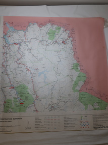
Map - Road Construction Authority 1986, Ref. Tallangatta 282008
Government authorities updated maps regularly.Historically of interest eg. 1. Pre dates the Alpine National Park. 2. 'Mt Beauty Estates' now known as Tawonga South. 3. Mt Niggerhead is named - It is now known as Mt Jaithmathang having been renamed in 2009.Colored map dated 1986 titled Road Construction Authority with an update of roads in the local Shires. It names places in the area and has a legion describing the rating of the roads and tracks. It also shows the main towns in the area and their roads.road construction authority, map of tallangatta area -
 Eltham District Historical Society Inc
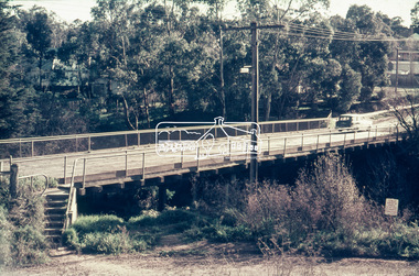
Slide - Photograph, Russell Yeoman, Para Road / Carter Street Bridge over the Plenty River, Briar Hill, c.Jul 1969
Bridge over the Plenty River at Briar Hill before widening and alterations. The Plenty River at Briar Hill represented the boundary between the Shire of Eltham and the Shire of Diamond Valley. The bridge was known as the Carter Street Bridge as prior to 1969 Para Road, Briar Hill became Carter Street, Greensborough across the river. It was at this time that the name Para Road was continued and replaced Carter Street.35mm colour positive transparency blue Agfacolour Service plastic mount1969-07, briar hill, carter street bridge, para road, para road bridge, shire of diamond valley, shire of eltham, bridge, plenty river, shire of eltham pioneers photograph collection -
 Eltham District Historical Society Inc
Negative - Photograph, Russell Yeoman, Para Road / Carter Street Bridge over the Plenty River, Briar Hill, c.Jul. 1969
Bridge over the Plenty River at Briar Hill before widening and alterations. The Plenty River at Briar Hill represented the boundary between the Shire of Eltham and the Shire of Diamond Valley. The bridge was known as the Carter Street Bridge as prior to 1969 Para Road, Briar Hill became Carter Street, Greensborough across the river. It was at this time that the name Para Road was continued and replaced Carter Street.This photo forms part of a collection of photographs gathered by the Shire of Eltham for their centenary project book,"Pioneers and Painters: 100 years of the Shire of Eltham" by Alan Marshall (1971). The collection of over 500 images is held in partnership between Eltham District Historical Society and Yarra Plenty Regional Library (Eltham Library) and is now formally known as the 'The Shire of Eltham Pioneers Photograph Collection.' It is significant in being the first community sourced collection representing the places and people of the Shire's first one hundred years.Digital image 35 mm B&W negativeshire of eltham pioneers photograph collection, briar hill, 1969-07, bridge, carter street bridge, para road, para road bridge, plenty river, shire of diamond valley, shire of eltham -
 Surrey Hills Historical Society Collection
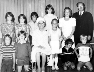
Photograph, Mrs Frances Le Couteur and members of the Surrey Hills Salvation Army Corps, 1977
Frances Charlotte Le Couteur (born c1893) taught at both Chatham and Canterbury Primary Schools and at the Salvation Army in Guildford Road. She lived in Guildford Road for part of her life and taught music. She was on the staff of Chatham Primary when it opened in August 1927. She taught at Canterbury Primary for 20 years. She retired to live in Inala Village. Obituary: Frances Charlotte Le Couteur, of Inala Village died on June 17th, 1986. Loving wife of Norman (dec.), loved mother of Frank (dec.), and Boyce and grandmother of Ann, Sally and Guy. Great grandmother to Peter, James and Annabel. Date of photo is approximate.Black and white photo of Mrs Frances Le Couteur seated with a group of 10 children and a Salvation Army officer at the Salvation Army citadel in Guildford Road, Surrey Hills.salvation army, children, music, religion, mrs frances lecouteur -
 Eltham District Historical Society Inc
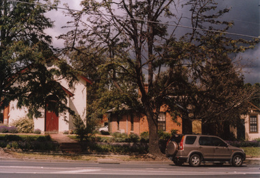
Photograph, Eltham Courthouse, Sept. 2008, 2008
Three colour photographs of Eltham Courthouse, Sept. 2008. Viewed from across Main Road opposite 728/730 Main Road. One view looking north towards Eltham Hotel shows some of the replacement Plane trees, part of the Avenue of Honoureltham, main road, courthouse, avenue of honour -
 Eltham District Historical Society Inc
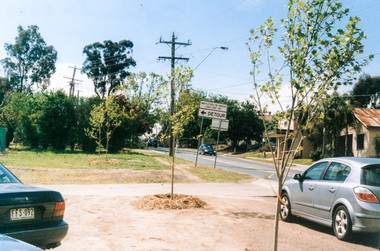
Photograph, Eltham Courthouse, Sept. 2008, 2008
Three colour photographs of Eltham Courthouse, Sept. 2008. Viewed from across Main Road opposite 728/730 Main Road. One view looking north towards Eltham Hotel shows some of the replacement Plane trees, part of the Avenue of Honoureltham, main road, courthouse, avenue of honour -
 Eltham District Historical Society Inc
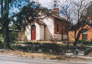
Photograph, Eltham Courthouse, Sept. 2008, 2008
Three colour photographs of Eltham Courthouse, Sept. 2008. Viewed from across Main Road opposite 728/730 Main Road. One view looking north towards Eltham Hotel shows some of the replacement Plane trees, part of the Avenue of Honoureltham, main road, courthouse, avenue of honour -
Whitehorse Historical Society Inc.
Letter - Correspondence, House 113 Springvale Road, Nunawading, n.d
A letter from Nance Leach (undated) telling the history of John McClelland's house. He arrived from Ireland in 1863...5 years later they selected 80 acres at Tunstall (Nunawading) and cultivated a market garden, The property was on the site of Stanley Engineering. The couple and one daughter retained the house and Whitehorse Road section of the property about 1948. This was sold to 'Turners' on condition Turners removed the house to 113 Springvale Road for Miss Tess McClelland. When she died the house was sold to Hal Johnson and he later sold it to Mr Florio. John McClelland died 1911 aged 77. The house was called 'The Elms'.springvale road, nunawading, no 113 (the elms), nunawading, mcclelland, john, stanley works pty ltd, turner industries, mcclelland, tess, johnson, hal, florio (mr) -
 Southern Sherbrooke Historical Society Inc.
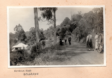
Photograph, Monbulk Road, Belgrave
Groups of people are standing on Monbulk Road, up from Belgrave. In the background are four women abreast walking away. There are two men, a young boy and a woman standing together in the middle ground and two younger women closer to the camera, standing beside a cart (with only a large cartwheel visible). There may be another man speaking to them. There is a path going up the hill to the right, with fence posts on the high side and a closed gate at the top. On the left of the photo there is a house below the road. There are two water tanks which look new. It may be the same house as appears in other photos in this collection. Another building is visible in the distance. -
 Melbourne Tram Museum
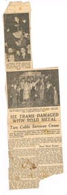
Newspaper, The Argus, "Six Trams Damaged with Road Metal", 15/03/1937 12:00:00 AM
Newspaper Clipping - from The Argus Monday 15/3/1937, titled "Six Trams Damaged with Road Metal", about the damage caused at the time of the closure of the South Melbourne and Port Melbourne cable tram services - by souvenir hunters and people at the Port Melbourne depot who through road metal (stones) at the trams as they came into the depot. The timeline gives the date of closure as Saturday 13/3/1937. Notes one of the Gripmen was a Mr. J. Armstrong. A comparison with the cutting as collected and the reproduction in The Argus on Trove, while the same photographs has a different text layout and text, possibly indicating two different editions of the paper.trams, tramways, collins st, port melbourne, south melbourne, cable trams, closure, buses -
 Eltham District Historical Society Inc
Photograph, 35 Ingrams Road, Research, Eltham Heritage Tour, 24 May 1992, 24/05/1992
ELTHAM HERITAGE TOUR The Society excursion on 24th May 1992 was arranged by David Bick, leader of the team carrying out the Shire's heritage study. David selected a number of sites or buildings identified in the study, some of them lesser known components of the Shire's heritage. The tour commenced at the Eltham Shire Office at 10.00 am. Travel was by private car and mini-bus with stops at about twelve locations for commentary by David.It included a short walk in Hurstbridge and lunch at Kinglake. Highlights of the tour included: - 10 am Leave from Shire Offices - 3 Important Trees - A Physical Link to Eltham's First Settlers - Toorak Mansion Gates - A Surviving Farm House - An Intact Circa 1900 Main Street - First Settlers - Gold Miners, and Timber-getters - An Early Hotel - A Pioneering Homestead - Changing Eltham Shire - 20th Century - 4 pm Afternoon Tea and Finish Tour Extract from ELTHAM CULTURAL HERITAGE TOUR (Newsletter No. 85, July 1992, by Bettina Woodburn) "On a right-angle turning of the Eltham Road is Wellers Pub, a Cobb & Co. coaching stop on the way to distant gold-fields and places north of the Yarra River. The Hotel dates from the 1870's. Daily distances for a bullock team was eight miles, horses could do double that distance. We turned into Cassells Road and on the corner of Ingrams Road we admired an elaborate Edwardian villa, 1900 style. The Aqueduct conveying Melbourne's water supply was a communication line and a technological advance in 1891. It has been enlarged and re-faced and no longer used here but piped underground. Proclaimed a linear park it has reverted to crown land, controlled by local Council. Maroondah Dam was constructed in. 1920 to replace the original weir and at that time: the Aqueduct - as established into the landscape - with bridges and tunnels and pine trees were used to stop rubbish polluting the water."Record of the Society's history and activities and highlighting various aspects of the Heritage Study undertaken by David Bick used to create the future heritage overlay for the Shire of Eltham and later Nillumbik Shire.Roll of 35mm colour negative film, 4 stripsKodak Gold 100 5095shire of eltham historical society, activities, heritage tour, ingrams road, research (vic.) -
Federation University Historical Collection
Map, City of Ballarat and Borough of Sebastopol Road Map
Road map of the City of Ballarat and the Borough of Sebastopol. WGS 85 Centroid 37 degrees 33 feet 56 inches south 143 degrees 51 feet 09 inches eat E-W- extent: 9 km N-S- extent: 11.5 kmballarat, sebastopol, map, plan, ballarat shire -
 Ballarat Heritage Services
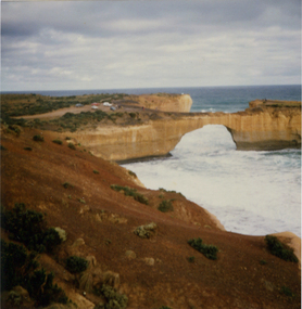
Photograph, London Bridge, Great Ocean Road, 01/1990
London Bridge, pre 1990 was a double-spanning bridge connected to the mainland. The stack was created over hundreds of years, with the weaker layers toward the base being eroded away by wind and water to form the two bridges. The span closer to the shoreline collapsed unexpectedly on 15 January 1990, leaving two visitors, whilst uninjured, stranded on the outer span before being rescued by helicopter. Two coloured photographs of the London Bridge, on the Great Ocean Road. This photo was taken days before the collapse of the geological feature. The photographer walked across the bridge to the warning of her mother "if you go over there and it collapses you will be stuck. After the collapse it was renamed London Arch. london bridge, great ocean road, london bridge, peterborough, london arch, shipwreck coast, 12 apostles -
 Otway Districts Historical Society
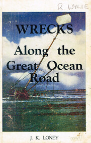
Book, Wrecks along the Great Ocean Road, 1974
Many fine ships were lost along Victoria's western coastline and evidence suggests a number of unidentified wrecks went down many years earlier.Wrecks along the Great Ocean Road. Shipwrecks of the west coast from Point Lonsdale to Portland. J.K. Loney. 4th ed. Dimboola (Vic); J.K. Loney; 1974. iii, 137 p.; illus, maps. Soft cover. ISBN 0 9599853 8 7shipwrecks; great ocean road; j.k. loney; west coast; strandings;portland; port fairy; warrnambool; point lonsdale; -
 Falls Creek Historical Society
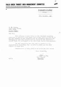
Letter - Requesting Permission To Construct New Access Road, 18.12.1959
Bob Hymans Collection Bob (Herman) Hymans (a former pilot in the Royal Netherlands Navy was born in Bloemendaal, Holland on 30 September 1922. He fought against the Japanese in the Dutch East Indies (now Indonesia) and was imprisoned in Changi and on the Burma Railway. After gaining qualifications as a ski instructor, Bob arrived in Falls Creek in May 1950. After working as an instructor and supervisor at Bogong Lodge, Bob decided his future was in accommodation. After negotiating an indenture for land from the State Electricity Commission (SEC), Bob took two years to build his Grande Coeur Chalet. It burned down in August 1961. Bob also built the first chairlift in Australia. This was a single chairlift and the structure was built from wooden electricity poles. He was constantly full of new ideas and proposals for the village. Bob Hymans died on 7 May 2007. This Collection of documents and letters tells the story of Bob’s endeavours to develop Falls Creek into the ski village it is today.Bob Hymans Collection Bob (Herman) Hymans (a former member of the Royal Netherlands Navy was born in Bloemendaal, Holland on 30th September 1922. During World War II he fought against the Japanese in the Dutch East Indies (now Indonesia) and was imprisoned in Changi and on the Burma Railway. After gaining qualifications as a Ski Instructor, Bob arrived in Falls Creek in May 1950. Working as an Instructor and Supervisor at Bogong Lodge, Bob decided his future was in accommodation. He was successful in negotiating an indenture for land from the State Electricity Commission (SEC). It took Bob two years to build his Grande Coeur Chalet but, tragically, it was burned down in August 1961. Bob also built the first Chairlift in Australia. This was a single chairlift and the structure was built from wooden electricity poles. He was constantly full of new ideas and proposals for the village. Bob Hymans died on 7th July 2007. This Collection of documents and letters tells the story of Bob’s endeavours to develop Falls Creek into the ski village it is today.This document is significant because it documents the Rules of Falls Creek Tourist Area Regulations 1959.A letter from the Falls Creek Tourist Area Management Committee referring to his request to build a new access road to his Grand Coeur Chalet. It states that the request must be considered in context of the overall plans of the Falls Creek Tourist Area but progress is being made.bob hymans, falls creek tourist area management committee -
 Melbourne Tram Museum
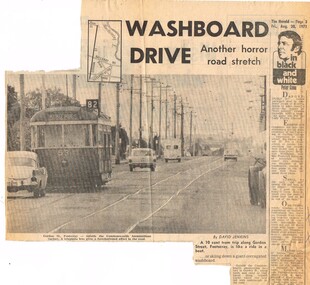
Newspaper, The Herald, "Washboard Drive - Another horror road stretch", 20/08/1971 12:00:00 AM
Newspaper clipping The Herald, 20/8/1971 titled "Washboard Drive - Another horror road stretch", about the condition of the pavement surface in Gordon St Footscray - like travelling on a corrugated washboard. Has a photo of No. 53, with the destination of Moonee Ponds - taken with a telephoto lens.trams, tramways, gordon st, trackwork, footscray -
 Eltham District Historical Society Inc
Negative - Photograph, J.A. McDonald, Heidelberg-Kinglake Road, 11 May 1961
Silvan Road Bridge Looking northwards before reconstruction View centreline to left of old bridge site 11 May 1961Record of various Shire of Eltham infrastructure works undertaken during the period of 1952-1962 involving bridge and road reconstruction projects, sometimes with Eltham Shire Council Project Reference numbers quoted. It was during this period that a number of significant improvements were made to roads and new bridges constructed within the shire that remain in place as of present day (2022). In many situations, the photos provide a tangible visible record of infrastructure that existed throughout the early days of the Shire. The album was put together by or under the direction of the Shire Engineer, J.A. McDonald.1961-05-11, heidelberg-kinglake road, infrastructure, bridge construction, shire of eltham, reconstruction works, road construction, silvan road bridge -
 Greensborough Historical Society
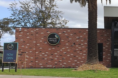
Photograph - Photograph - Digital Image, Marilyn Smith, Yarra Trail Medical 113 Mountainview Road Montmorency, 04/09/2021
Digital image of Yarra Trail Medical 113 Mountainview Road Montmorency. This medical centre was purpose built following a fire at this address.Part of a collection of miscellaneous historical images with a connection to the local area.Digital colour photograph. yarra trail medical, mountainview road briar hill, medical centres -
 Greensborough Historical Society
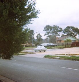
Photograph, Vacant land, Corner Wilson Avenue and Rattray Road Montmorency 1985, 1985_
A photograph of vacant land, Corner Wilson Avenue and Rattray Road Montmorency 1985, taken by Peter Graham, a Shire of Eltham Councillor.1 colour photograph.montmorency, peter graham, rattray road montmorency, wilson avenue montmorency -
 Greensborough Historical Society
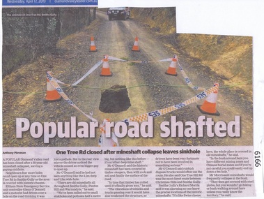
Newspaper Clipping, Diamond valley Leader, Popular road shafted, 17/04/2019
A popular Diamond Valley road has been closed after a 50 year old mineshaft collapsed, leaving a gaping sinkhole.News article 1 page, black text, colour image.diamond valley, one tree rd smiths gully, sinkhole, mines and mining -
 Greensborough Historical Society
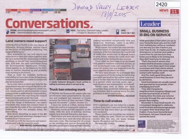
Newspaper Clipping, Conversations - Nillumbik Environment - Banyule Rosanna Road Truck Ban - Snakes, 18/11/2015
Letters to the Editor, Diamond Valley Leader, 18/11/2015 discussing environmental issues in Nillumbik and the truck ban on Rosanna Road.News clipping, black text, colour image.truck curfew, nillumbik -
 Stawell Historical Society Inc
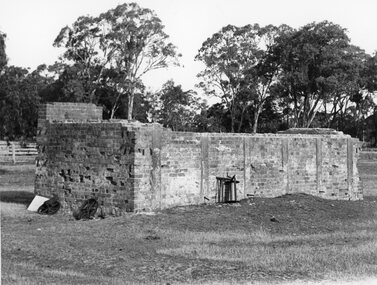
Photograph, Brick remains of the Tannery of Mr C Whel off Halls Gap Road Stawell West behind the London Hotel 1982
Brick remains of Tannery run by C Whel off Halls Gap Road Stawell West behind the London Hotel 1982stawell industry -
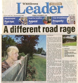 Whittlesea Historical Society Inc.
Newspaper - Newspaper Clipping, Whittlesea Leader, A different road rage, 22 Nov 2005
Jean and Richard Ely fear that works to widen Plenty Road Mernda will damage their 147-year-old bluestone house the "Poplars". Mayfield Precinct is home to some of the oldest buildings in the regionNewsprint with colour photo.mernda, jean ely, richard ely, bluestone house, the poplars mernda, mayfield precinct