Showing 17530 items
matching plenty-hotel
-
 Eltham District Historical Society Inc
Photograph - Digital Photograph, Alan King, Wellers Restaurant, 150 Eltham-Yarra Glen Road, Kangaroo Ground, 23 January 2008
Originally Wellers Hotel, it was constructed by Edward Weller in 1872. Following his death in 1883 it was taken over by his widow, Mary Weller. The hotel was delicensed in 1909 and converted to a private residence. Around 1920 William Pitman bought the property, succeeded by his son Vernon who coined the term Pittman's Corner. Vernon and Isabel Pitman owned the house form 1945-1973. Following Vernon's death, Isabel remained there till her death in 1983. The property was converted to a restaurant in 1984 by owners Robert and Kath Hendry who undertook extensive renovations in 1988. Shawn and Stephanie Wolfe purchased the property from the Hendrys in 2003 and introduced live entertainment with many famous bands and entertainers from the 1960s, 1970s and 1980s performing there, including James Reyne, Daryl Barithwaite, Brian Cadd and Billy Thorpe. In 2014 the Wolfe's sold the property and the entire contents were sold at auction. New (local ) owners Gregory Anderson, Craig Jones and Steve Gist refurbished the property and relaunched it as Fondata 1872 in 2017. Covered under Heritage Overlay, Nillumbik Planning Scheme. Published: Nillumbik Now and Then / Marguerite Marshall 2008; photographs Alan King with Marguerite Marshall.; p87This collection of almost 130 photos about places and people within the Shire of Nillumbik, an urban and rural municipality in Melbourne's north, contributes to an understanding of the history of the Shire. Published in 2008 immediately prior to the Black Saturday bushfires of February 7, 2009, it documents sites that were impacted, and in some cases destroyed by the fires. It includes photographs taken especially for the publication, creating a unique time capsule representing the Shire in the early 21st century. It remains the most recent comprehenesive publication devoted to the Shire's history connecting local residents to the past. nillumbik now and then (marshall-king) collection, eltham-yarra glen road, fondata 1872, kangaroo ground, wellers restaurant, billy thorpe, brian cadd, craig jones, daryl barithwaite, edward weller, gregory anderson, hotels, james reyne, kath hendry, mary weller, restaurants, robert hendry, shawn wolfe, stephanie wolfe, steve gist -
 Eltham District Historical Society Inc
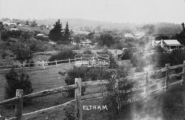
Photograph (item), J.H. Clark (poss), View of Eltham across Bridge Street, c.1907
The view is looking southeast from near Eltham Road (present-day Sherbourne Road) across Bolton and Bridge streets towards the village of Little Eltham running down the main road (Maria Street) . On the immediate right is Mrs Mary Jane Smart's family home located on the north side of Bridge Street at the intersection with Bolton Street, facing Bolton Street (now part of present day Brisbane Street and occupied by the Kitchen Design Centre). An original early settler's cottage, it was built by Mary Jane Smart's parents, Edwin Bailey and Jane (nee Matthews). Mary Jane Smart was born in the cottage. She married an Englishman, Alexander Wilson Smart who disappeared to Western Australia in the early 1900s in search of gold. He ultimately married again in W.A., committing bigamy and then committed murder and was hung in 1911. Visible att the top left are Watson's (two-storey) Eltham Hotel at the corner of Pitt Street and Maria Street and the Evelyn Hotel directly opposite. The photo was possibly taken by John Henry Clark of Clark Bros Photographers who operated from 25 Thompson Street, Windsor near Prahan 1894-1914.bridge street, clark bros. photo, early settlers, eltham, evelyn hotel, fountain of friendship hotel, j.h. clark photo, mary jane smart (nee bailey), smart family home, smart home, watsons hotel -
 Bendigo Historical Society Inc.
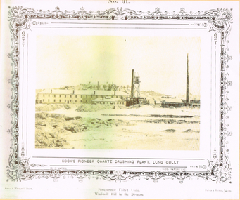
Photograph - LONG GULLY HISTORY GROUP COLLECTION: KOCK'S PIONEER QUARTZ CRUSHING PLANT LONG GULLY
The initial partnership in a quartz crushing plant between Henry Koch, Simon Albert and Charles Wallin was dissolved in 1860 with Koch becoming the sole owner. In 1866 the crushing plant consisted of a 50 hp engine and 48 stamping heads capable of crushing 600 tons of quartz per week. By 1902 there were 72 stamps and this was by far the largest crushing plant in the area, serving many quartz mines. Henry Koch (1800-1889) was a German sailor who signed off when his ship reached Melbourne in 1851. Having heard of the gold discovery he proceeded to Bendigo where he was initially employed in puddling in the Myers Flat area. He was soon employed and then made partner in a quartz crushing plant that he became sole owner of in 1860. He was also landlord at the British and American Hotel and the Silver Mines Hotel. HE also started the Perseverance United gold claim. He married Anna Maria Theresia Heinz in 1857. In 1872 he sold the crushing plant for 75,000 pounds and took his family back to Germany. He resumed his trade as a ship builder although he maintained many Bendigo mining interests.Yellow tone photo which has some green through it photo of Kock's Pioneer Quartz Crushing Plant, Long Gully. No 31 printed at the top. The photo has a decorative frame around it. It is a N. J. Caire Photo, Sandhurst and a Casey & Wenborn's Print. Forbes & Holmes, Agents. The photo has a long two storey building with chimneys and some smaller buildings and tall mine chimneys. Printed below is Perseverance United Claim and Windmill Hill in the distance. Paper is mounted on yellow card which is mounted on dark tan card and laminated.bendigo, history, long gully history group, the long gully history group - koch's pioneer quartz crushing plant - long gully, n j caire, casey & wenburn, forbes & holmes, perseverence united claim, windmill hill -
 Bendigo Historical Society Inc.
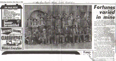
Newspaper - LONG GULLY HISTORY GROUP COLLECTION: KOCK'S MINE WORKERS
The initial partnership in a quartz crushing plant between Henry Koch, Simon Albert and Charles Wallin was dissolved in 1860 with Koch becoming the sole owner. In 1866 the crushing plant consisted of a 50 hp engine and 48 stamping heads capable of crushing 600 tons of quartz per week. By 1902 there were 72 stamps and this was by far the largest crushing plant in the area, serving many quartz mines. Henry Koch (1800-1889) was a German sailor who signed off when his ship reached Melbourne in 1851. Having heard of the gold discovery he proceeded to Bendigo where he was initially employed in puddling in the Myers Flat area. He was soon employed and then made partner in a quartz crushing plant that he became sole owner of in 1860. He was also landlord at the British and American Hotel and the Silver Mines Hotel. HE also started the Perseverance United gold claim. He married Anna Maria Theresia Heinz in 1857. In 1872 he sold the crushing plant for 75,000 pounds and took his family back to Germany. He resumed his trade as a ship builder although he maintained many Bendigo mining interests.Photocopy of an article from the Bendigo Advertiser, dated 5/5/1982 titled Fortunes carried in mine. Written above the photo is: Men from Kock's Mine Long Gully. One man is wearing a suit and the rest are in work clothes. The mine was worked, with some breaks, between 1857 and 1871 when the Pioneer Company took over, and was later known as Koch's Pioneer and Perseverance and worked continuously until 1924, a period of 53 years of uninterrupted mining.bendigo, history, long gully history group, the long gully history group - kock's mine workers, bendigo advertiser 5/5/1982, kochs pioneer mine, henry koch, havilah company's claim, garden gully line of reef, paddy's gully line, koch's pioneer and perseverance -
 Bendigo Historical Society Inc.
Negative - ALBERT RICHARDSON COLLECTION: KOCH'S PIONEER CRUSHING BATTERY (EARLY PERIOD)
The initial partnership in a quartz crushing plant between Henry Koch, Simon Albert and Charles Wallin was dissolved in 1860 with Koch becoming the sole owner. In 1866 the crushing plant consisted of a 50 hp engine and 48 stamping heads capable of crushing 600 tons of quartz per week. By 1902 there were 72 stamps and this was by far the largest crushing plant in the area, serving many quartz mines. Henry Koch (1800-1889) was a German sailor who signed off when his ship reached Melbourne in 1851. Having heard of the gold discovery he proceeded to Bendigo where he was initially employed in puddling in the Myers Flat area. He was soon employed and then made partner in a quartz crushing plant that he became sole owner of in 1860. He was also landlord at the British and American Hotel and the Silver Mines Hotel. HE also started the Perseverance United gold claim. He married Anna Maria Theresia Heinz in 1857. In 1872 he sold the crushing plant for 75,000 pounds and took his family back to Germany. He resumed his trade as a ship builder although he maintained many Bendigo mining interests.Envelope containing a negative of Koch's Pioneer Crushing Battery. Image shows large building, chimney on left. Negative not scanned.bendigo, mining, koch's pioneer crushing battery -
 Bendigo Historical Society Inc.
Photograph - Norman Penrose collection: Views of Bendigo No.31
The initial partnership in a quartz crushing plant between Henry Koch, Simon Albert and Charles Wallin was dissolved in 1860 with Koch becoming the sole owner. In 1866 the crushing plant consisted of a 50 hp engine and 48 stamping heads capable of crushing 600 tons of quartz per week. By 1902 there were 72 stamps and this was by far the largest crushing plant in the area, serving many quartz mines. Henry Koch (1800-1889) was a German sailor who signed off when his ship reached Melbourne in 1851. Having heard of the gold discovery he proceeded to Bendigo where he was initially employed in puddling in the Myers Flat area. He was soon employed and then made partner in a quartz crushing plant that he became sole owner of in 1860. He was also landlord at the British and American Hotel and the Silver Mines Hotel. HE also started the Perseverance United gold claim. He married Anna Maria Theresia Heinz in 1857. In 1872 he sold the crushing plant for 75,000 pounds and took his family back to Germany. He resumed his trade as a ship builder although he maintained many Bendigo mining interests.Sepia coloured photograph of Koch's Pioneer quartz crushing plant, Long Gully. The phot shows Perseverance United claim, Wind-mill and hill in the distance. N.J. Caire phot Sandhurst.Casey & Wenborn's print. Forbes & Holmes agentsviews of bendigo, n.j. caire, sandhurstr, quartz crushing plant, kock -
 Bendigo Historical Society Inc.
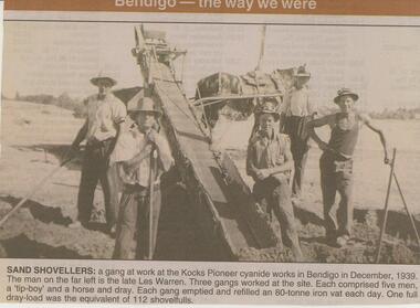
Newspaper - JENNY FOLEY COLLECTION: SAND SHOVELLERS
The initial partnership in a quartz crushing plant between Henry Koch, Simon Albert and Charles Wallin was dissolved in 1860 with Koch becoming the sole owner. In 1866 the crushing plant consisted of a 50 hp engine and 48 stamping heads capable of crushing 600 tons of quartz per week. By 1902 there were 72 stamps and this was by far the largest crushing plant in the area, serving many quartz mines. Henry Koch (1800-1889) was a German sailor who signed off when his ship reached Melbourne in 1851. Having heard of the gold discovery he proceeded to Bendigo where he was initially employed in puddling in the Myers Flat area. He was soon employed and then made partner in a quartz crushing plant that he became sole owner of in 1860. He was also landlord at the British and American Hotel and the Silver Mines Hotel. HE also started the Perseverance United gold claim. He married Anna Maria Theresia Heinz in 1857. In 1872 he sold the crushing plant for 75,000 pounds and took his family back to Germany. He resumed his trade as a ship builder although he maintained many Bendigo mining interests.Bendigo Advertiser ''The way we were'' from 2002. Sand shovelers: a gang at work at the Kocks Pioneer cyanide works in Bendigo in December, 1939. The man on the far left is the late Les Warren. Three gangs worked at the site. Each comprised five men, a 'tip-boy' and a horse and dray. Each gang emptied and refilled an 80-tonne iron vat each day. One full dray-load was the equivalent of 112 shovelfuls. The clip is in a folder.newspaper, bendigo advertiser, the way we were -
 The Beechworth Burke Museum Research Collection
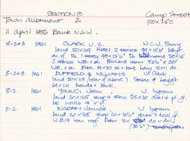
Card (Series) - Index Card, George Tibbits, Camp Street, Beechworth, 1976
George Tibbits, University of Melbourne. Faculty of Architecture, Building and Town & Regional PlanningIndex system that support the research for Beechworth : historical reconstruction / [by] George Tibbits ... [et al]Arranged by street names of BeechworthEach index card includes: street name and number of property, image of property, allotment and section number, property owners and dates of ownership, description of the property according to rate records, property floor plan with dimensions.beechworth, george tibbitsbeechworth, george tibbits -
![Township of Lorne, and Loutitt Bay / [by] Nicholas Caire, circa 1876](/media/collectors/550653872162f11fb04854aa/items/5783458ad0cdd1176c6f0c78/item-media/578345eed0cdd1176c6f852b/item-fit-380x285.jpg) Kew Historical Society Inc
Kew Historical Society IncPhotograph, Anglo-Australasian Photographic Company, Township of Lorne, and Loutitt Bay, c. 1876
Nicholas Caire was born on Guernsey in the Channel Islands in 1837. He arrived in Adelaide with his parents in about 1860. In 1867, following photographic journeys in Gippsland, he opened a studio in Adelaide. From 1870 to 1876 he lived and worked in Talbot in Central Victoria. In 1876 he purchased T. F. Chuck's studios in the Royal Arcade Melbourne. In 1885, following the introduction of dry plate photography, he began a series of landscape series, which were commercially successful. As a photographer, he travelled extensively through Victoria, photographing places few of his contemporaries had previously seen. He died in 1918. Reference: Jack Cato, 'Caire, Nicholas John (1837–1918)', Australian Dictionary of Biography.An original, rare photograph from the series 'Views of Victoria: General Series' by the photographer, Nicholas Caire (1837-1918). The 60 photographs that comprise the series were issued c. 1876 and reinforced a neo-Romantic view of the Australian landscape to which a growing nationalist movement would respond. Nicholas Caire was active as a photographer in Australia from 1858 until his death in 1918. His vision of the Australian bush and pioneer life had a counterpart in the works of Henry Lawson and other nationalist poets, authors and painters.‘Township of Lorne, and Loutitt Bay’ : Views of Victoria (General Series) No.60 : Albumen silver photograph | Photo on card with Title and Description on reverse | Mounted 24 x 30 cm; Photo 12 x 17 cm.On Reverse: ‘Loutitt Bay is fast becoming one of the most fashionable Watering-places in Victoria, partly from its easy access by Rail, combined with the magnificent scenery to be found in the Cape Otway Ranges, and the very moderate charges of the houses of accommodation. The large house near the foreground is that of Mr. Mountjoy, which is a Restaurant. Duncan’s Hotel can be seen in the distance, on the brow of the hill.’nicholas caire (1837-1918), lorne (vic), duncan's hotel, loutitt bay, landscape photography - victoria -
 Kiewa Valley Historical Society
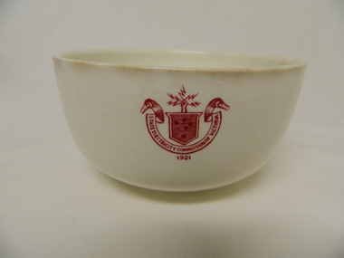
Bowl Ceramic - SECV
This bowl was used by the SECV in their mess rooms for workers during the construction of the Kiewa Hydro Electric Scheme. The imprint of the year '1921' was to identify the year that the SECV was formed which relieved the private VHEC (Victorian Hydro-Electric Company). As the scheme was of such a huge scope, isolated and time consuming nature, the feeding of its workers was quite demanding of cutlery and crockery. (See more KVHS 0113)This bowl was used by SECV workers working on the Kiewa Hydro Electric Scheme (1938 - 1961) in camps and mess halls and at the Mt Beauty chalet. (See more KVHS 0113)This item is a white ceramic State Electricity Commission of Victoria bowl. It is made in England and is of strong and durable ceramic. The 5 mm thickness of the ceramic suggests this bowl (cereal / soup) belongs to a commercial kitchen environment and not domestic. The indent bottom of the bowl is 5 mm deep with a side curvature ratio of 2:5. The ceramic is glazed to a commercial standard (workers' mess). See also KVHS 0128 (B - D) for other ceramic crockery.The red printed seal of the State Electricity Commission of Victoria is imprinted on the top outside rim within a curved scroll and a raised fist with electrical "Charges" extending out. Snuggled within the borders of the scroll is a banner with the 5 stars of the Southern Cross. On the underside "Vitrified sold by Cafe & Hotel Supplies Pty Ltd Dunn Bennett & Co. Ltd. Burslem. Made in Englandcrockery; state electricity commission of victoria; dunn bennett pty. ltd.; bowl -
 Ballarat Tramway Museum
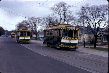
Photograph - Digital image Set of 8, 21/08/1971 12:00:00 AM
Yields information about the SEC Ballarat trams in the months before the closure of the SEC Tramway system. Yields information about the streetscape. Set of 8 Digital images, scanned from slides by Graeme Cleak, scanning by Peter Winspur 9/2011. .1 - Slide FS14 - No. 31 and 32 crossing at the High St Loop in Macarthur St. Tram 31 has the destination of Victoria St. Geoff Dean and his mini on the right hand side of the photograph. Another depot bound single trucker in the photograph, .2 - Slide FS3 - 31 outbound in Victoria St, with St Alipius church in the background. .3 - Slide FS5 - No. 31, and four other trams, some running special at Sturt and Lydiard Sts during the ARHS tour of that day. Has the ANZ Bank and SEC offices in the background. .4 - Slide FS9 - Nos. 39, 26 and two other trams in Lydiard St for the ARHS tour with Reid's Palace, Macleod & Co and J.J. Collier buildings in the background along with other buildings in Lydiard St North. Taken from the Provincial Hotel. .5 - Slide FS11 - No. 26 northbound showing Special running through the level crossing at Ballarat with the Kennedy Murray General Carrier in the background. Taken from the Provincial Hotel. .6 - Slide FS13 - No. 32 turning from Sturt St into Drummond Street North showing Depot via Drummond North, with the Southern Cross Hotel, Rimmington Bros and J.A, Malpass(?) buildings in the background. .7 - Slide FR35 - night shot of No. 17 (with Twin Lakes sign) and No. 32 in Nos 3 and 4 roads at the depot. .8 - Slide FR34 - night shot of the front of the depot - as above and No. 43 on "0" road. All photos 21-8-1971 trams, tramways, railway station, macarthur st, victoria st, sturt st, lydiard st north, level crossings, depot, tram 31, tram 32, tram 39, tram 26, tram 17, tram 43 -
 Eltham District Historical Society Inc
Photograph - Digital Photograph, Marguerite Marshall, Stuchbery Farm dairy, 14 March 2008
Stuchbery Farm was situated on the Plenty River bounded by Smugglers Gully to the north and La trobe Road, Yarrambat, to the east. Alan and Ada Stutchbery moved to the valley in 1890, first living in a tent where four children were born. Alfred built a home and outbuildings around 1896. They planted an orchard, then a market garden and developed a dairy. Published: Nillumbik Now and Then / Marguerite Marshall 2008; photographs Alan King with Marguerite Marshall.; p179 The dramatic steep-sided Plenty Gorge lies along the divide of two geological areas, and separates the Nillumbik Shire and the City of Whittlesea. On the Nillumbik side are undulating hills and sedimentary rock, and in Whittlesea, lies a basalt plain formed by volcanic action up to two million years ago. This provides the Plenty Gorge Park with diverse vegetation and habitats, making it one of Greater Melbourne’s most important refuges for threatened and significant species. The park, established in 1986, consists of around 1350 hectares, and extends 11 kilometres along the Plenty River, from Greensborough to Mernda. It provides a wildlife corridor for around 500 native plant and 280 animal species. The area’s plentiful food and water attracted the Wurundjeri Aboriginal people and then European settlers. By 1837 squatters had claimed large runs of land for their sheep and cattle. The Plenty Valley was among the first in the Port Phillip District to be settled - mainly in the less heavily timbered west - and was proclaimed a settled district in 1841. But by the late 1880s, the settlers’ extensive land clearing for animal grazing, then agriculture, depleted the Wurundjeri’s traditional food sources, which helped to drive them away. Many Wurundjeri artefacts remain (now government protected), and so far 57 sites have been identified in the park, including scarred trees, burial areas and stone artefacts. Pioneer life could be very hard because of isolation, flooding, bushfires and bushrangers. Following the Black Thursday bushfires of 1851, basalt was quarried to build more fire-resistant homes. Gold discoveries in the early 1850s swelled the population, particularly around Smugglers Gully; but food production made more of an impact. In the late 1850s wheat production supplanted grazing. In the 1860s the government made small holdings available to poorer settlers. These had the greatest effect on the district, particularly in Doreen and Yarrambat, where orchards were established from the 1880s to 1914. Links with a prominent early family are the remains of Stuchbery Farm, by the river’s edge bounded by Smugglers Gully to the north and La Trobe Road, Yarrambat, to the east. The Stuchberys moved to the valley in 1890, and the family still lives in the area. In 1890, Alfred and Ada first lived in a tent where four children were born, then Alfred built the house and outbuildings around 1896. They planted an orchard, then a market garden, and developed a dairy. The family belonged to the local Methodist and tennis communities. Their grandson Walter, opened the Flying Scotsman Model Railway Museum in Yarrambat, which his widow, Vi, continues to run. Wal was also the Yarrambat CFA Captain for 22 years until 1987. Walter sold 24 hectares in 1976 for development - now Vista Court - and in 1990, the remaining 22.6 hectares for the park. Remaining are an early stone dairy and remnants of a stone barn, a pig sty and a well. Until it was destroyed by fire in 2003, a slab hut stood on the Happy Hollow Farm site, at the southern end of the park. The hut is thought to have been built in the Depression around 1893. This was a rare and late example of a slab hut with a domestic orchard close to Melbourne. Emmet Watmough and his family first occupied the hut, followed by a succession of families, until the Bell family bought it around 1948. There they led a subsistence lifestyle for 50 years, despite encroaching Melbourne suburbia. The Yellow Gum Recreation Area includes the Blue Lake, coloured turquoise at certain times of the year. Following the 1957 bushfires, this area was quarried by Reid Quarries Pty Ltd for Melbourne’s first skyscrapers, then by Boral Australia. However in the early 1970s water began seeping into the quarry forming the Blue Lake and the quarry was closed. The State Government bought the site in 1997 and opened it as a park in 1999.This collection of almost 130 photos about places and people within the Shire of Nillumbik, an urban and rural municipality in Melbourne's north, contributes to an understanding of the history of the Shire. Published in 2008 immediately prior to the Black Saturday bushfires of February 7, 2009, it documents sites that were impacted, and in some cases destroyed by the fires. It includes photographs taken especially for the publication, creating a unique time capsule representing the Shire in the early 21st century. It remains the most recent comprehenesive publication devoted to the Shire's history connecting local residents to the past. nillumbik now and then (marshall-king) collection, ada stuchbery, alan stuchbery, dairy, stuchbery farm, farm buildings, yarrambat, plenty gorge park -
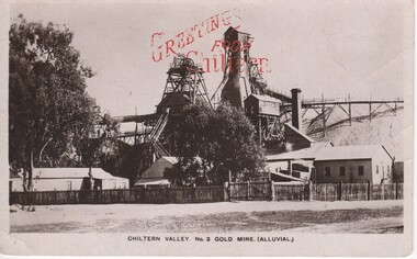 Rutherglen Historical Society
Image, F W Force, Chiltern Valley. No. 2 Gold Mine. (Alluvial.), c1900
Black and white postcard photograph of the upper structures of a gold mine and surrounding buildings.Printed in red at top of photo: "Greetings From Chiltern" Written on back of card: "c/o Mrs A. Smith. Melbourne Rd. Chiltern | Just a line to let you know I arrived safely and am having a good time. I went to a picnic on Easter Monday and had a great time. Did you go to the sports were they a success. We have plenty of music here Aggie plays the piano and I brought my violin up and a boy staying here from Melbourne sings. Hoping to hear from you soon. Your loving friend etc."chiltern, gold mining, mining industry, chiltern mine -
 Eltham District Historical Society Inc
Film - Video (VHS), Dynavision Video Production, 1994 Eltham Festival, 11 Nov 1994
20th Eltham Community Festival and last under the auspices of the Shire of Eltham. The Grand Parade focussing on the theme "Echoes of Eltham - Celebrating the visions of Eltrham from the past and into the future" was headed by Jock Read on his horse Lofty who had been filmed in an Anzac Day Parade on an earlier horse which had featured in the television show Matlock. The parade travelled north along Main Street to just past the Post Office then back south to Panther Place. Parade participants included 1st Eltham Brownies, 1st Eltham Venturers, 2nd Eltham Sea Scouts, 2nd Eltham Venturers, 3rd Eltham Brownies, Australian Democrats, Briar Hill Primary School, Circus Chaos, Country Fire Authority, Diamond Valley People for Disarmament, Diamond Valley Railway, Eltham Community Health Centre, Eltham District Horse and Pony Club, Eltham East Primary School, Eltham Fire Brigade, Eltham Junior Football Club (Panthers), Eltham Little Theatre, Eltham North Primary School, Eltham Playhouse Co-op, Eltham Pre-school, Eltham Roller Skating Club, Eltham South Pre-School Centre, Eltham Steam and Stationary Engine Society, Greenhills Neighbourhood House, Heidelberg Municipal Band, Hurstbridge Learning Co-op, Jocklebeary Farm, Kangaroo Ground Primary School, Learning Co-op Primary School, Lower Plenty Primary School, Main Road, Montmorency Gardening Club, Montmorency South Primary School, North Warrandyte Fire Brigade, Plenty Valley 88.6 FM, Research Pre-school, Research Primary School, Ron Sampson, Salvation Army Band (Briar Hill), Sherbourne Primary School, Shire of Eltham, State Emergency Service (Eltham) and Woodridge Pre-school. The parade commentary was provided by Plenty Valley FM 88.6 with guest commentator, Shire President Cr. John Graves. Following the parade is video footage from a helicopter of Alistair Knox Park, displays along Main Road and activities in Alistair Knox Park and the Rugby oval along with stationary engines, helicopter joyrides, Eltham People's Choir, music entertainment. Scenes also from the Diamond Valley Railway at Eltham Lower Park and finishing with the fireworks display. At the end of the video is a promotional video for Dynavision Video Production, a local video production company that produced the video and Diamond Photos (Kodak Express). One of the highlights of the festival was a tree planting ceremony in Alistair Knox Park to celebrate 123 years of the Shire of Eltham led by Shire President Cr. John Graves and representatives of the Wurrundjeri, traditional land owners of the area.VHS Video cassette (poor quality) Converted to MP4 file format 45:01, 535MB DVD copy of VHS cassette (better quality)1st eltham brownies, 1st eltham venturers, 2nd eltham sea scouts, 2nd eltham venturers, 3rd eltham brownies, 1994, aerial photographs, alistair knox park, arthur street, australian democrats, briar hill primary school, circus chaos, country fire authority, diamond valley people for disarmament, diamond valley railway, eltham community health centre, eltham district horse and pony club, eltham east primary school, eltham festival, eltham fire brigade, eltham junior football club (panthers), eltham little theatre, eltham lower park, eltham north primary school, eltham people's choir, eltham playhouse co-op, eltham pre-school, eltham roller skating club, eltham south pre-school centre, eltham steam and stationary engine society, grand parade, greenhills neighbourhood house, heidelberg municipal band, hurstbridge learning co-op, jock read, jocklebeary farm, john graves, kangaroo ground primary school, learning co-op primary school, lofty (horse), lower plenty primary school, main road, matlock police (tv show), montmorency gardening club, montmorency south primary school, nicholaus lauder estate, north warrandyte fire brigade, plenty valley 88.6 fm, research pre-school, research primary school, ron sampson, salvation army band (briar hill), sherbourne primary school, shire of eltham, state emergency service (eltham), video recording, woodridge pre-school -
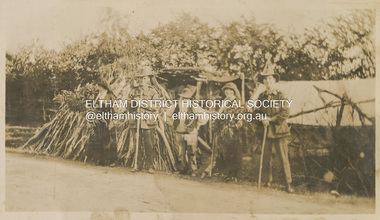 Eltham District Historical Society Inc
Photograph, "McGeachy, Curry, Byrne & Caffery with an old man who lives there at Eltham", 22 Oct 1919
This photo depicts an outing of VAD nurses Alice Broadhurst, McGeachy and Byrne and two patients of No. 16 AGH Macleod (Mont Park Military Hospital), Curry and Caffery to Eltham in spring 1919. Broadhurst's companions pose with an old timer from Eltham on the roadside verge with a large collection of sticks stacked vertically outside a cottage. This photo is part of the Alice Broadhurst collection held by Yarra Plenty Regional Library, a series of 12 photo albums compiled by Alice Broadhurst (1896-1981), initially while working as a Voluntary Aid Detachment nurse with the Australian Red Cross at the Mont Park Military Hospital (No. 16 AGH) and subsequently as a nurse at the Royal Melbourne and Royal Women’s hospitals alongside many pioneering doctors of their fields.Digital file"McGeachy, Curry, Byrne & Caffery with an old man who lives there at Eltham"eltham, alice elizabeth broadhurst, byrne, caffery, curry, mcgeachy, nursing staff, mont park, 16 agh, old timer, pioneer, cottage, wood pile -
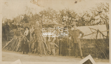 Eltham District Historical Society Inc
Photograph, "Same group with self instead of Byrne, Eltham", 22 Oct 1919
This photo depicts an outing of VAD nurses Alice Broadhurst, McGeachy and Byrne and two patients of No. 16 AGH Macleod (Mont Park Military Hospital), Curry and Caffery to Eltham in spring 1919. Broadhurst's companions pose with an old timer from Eltham on the roadside verge with a large collection of sticks stacked vertically outside a cottage. This photo is part of the Alice Broadhurst collection held by Yarra Plenty Regional Library, a series of 12 photo albums compiled by Alice Broadhurst (1896-1981), initially while working as a Voluntary Aid Detachment nurse with the Australian Red Cross at the Mont Park Military Hospital (No. 16 AGH) and subsequently as a nurse at the Royal Melbourne and Royal Women’s hospitals alongside many pioneering doctors of their fields.Digital file"Same group with self instead of Byrne, Eltham, Oct 22"eltham, alice elizabeth broadhurst, byrne, caffery, curry, mcgeachy, nursing staff, mont park, 16 agh, old timer, pioneer, cottage, wood pile -
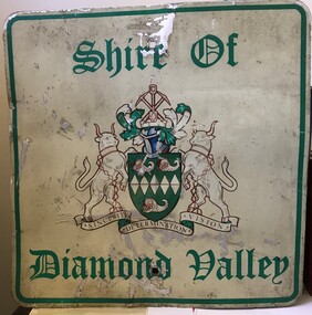 Greensborough Historical Society
Sign - Boundary Sign, Shire of Diamond Valley, Shire of Diamond Valley boundary sign, 1990s
The Shire of Diamond Valley was a Local Government Area located about 20 kilometres northeast of Melbourne. The shire covered an area of 74.38 square kilometres and existed from 1964 until 1994. This example of a Boundary Sign was one of many located on the edge of the Shire e.g. at Wattle Glen Station; at Yan Yean Road north of Bannons Lane; 2 on Plenty Road near Larundel and Bundoora Primary School; one on the Para Road bridge; on Wattletree Road Eltham and on Kurrak Road Yarrambat. According to a former Shire employee, the signs were often stolen as quickly as they were replaced. This sign was removed when the Shire of Diamond Valley was dissolved in 1994 and is signed by a Shire employee, giving it strong provenance.Painted metal sign, cream background with green text and Shire of Diamond Valley crest.Inscribed in felt tip pen on back of sign: SDV: from Nov 1964 to 1994. 30 years. Ron Middleton, By-laws Officer and Ranger, from 9/84 to Nov 94 [signed] R. Middletonshire of diamond valley, boundary signs -
![Photograph - Digital image, House St Helena and Diamond Creek Roads [Greensborough], 02/05/2013](/media/collectors/4f729f5697f83e03086015b8/items/5729bbd22162f108e8de5be2/item-media/5729bc112162f108e8de617d/item-fit-380x285.jpg) Greensborough Historical Society
Greensborough Historical SocietyPhotograph - Digital image, House St Helena and Diamond Creek Roads [Greensborough], 02/05/2013
These photographs of the house on the corner of St Helena and Diamond Creek Roads was taken in 2013 to show changes over 40 years, based on Ron Reynold's sketches in the 1973 publication 'Greensborough and Greenhills' published by Cypress Books... which states "Built on a steep hill in a bush setting in the early 1920s, for a Dr Wood, the weatherboard house now overlooks an area of activity and change. The owners, Mr and Mrs E. 'Bluey' Blackburn, remember when their 3/4 acre building block dropped to the edge of a dirt road. Today the view from the high verandah encompasses the Main Street shopping centre, new and old bridges, new roads and houses, the Plenty River, natural bush, hills and sports grounds."Digital copy of colour photograph.greensborough and greenhills, st helena road greensborough, diamond creek road greensborough, wood family, ron reynolds -
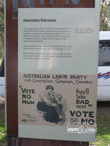 Eltham District Historical Society Inc
Photograph, Shire of Nillumbik World War One Memorials tour, 10 August 2016, 10 August 2016
As part of a program to acknowledge the Anzac Centenary Nillumbik Shire Council partnered with Yarra Plenty Regional Library to provide a bus tour with commentary of local sites of significance. These included Eltham township, the Shire of Eltham War Memorial at Kangaroo Ground, Christmas Hills, Hurstbridge memorial recreation park and finished at Eltham Library to view the Writing the War exhibtion at Eltham Library Community Gallery. In June 2014 Nillumbik Shire Council received Anzac centenary Local Grants Program funding to create new interpretative signage that acknowledged the history of the Hurstbridge Memorial Recreation Park as a memorial to all who served in the First World War. One of the tall panels includes a discussion of conscription in World War One. Born Digitalworld war 1, war memorials, shire of nillumbik, hurstbridge, interpretative signage, conscription -
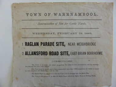 Warrnambool and District Historical Society Inc.
Document, Voting paper Cattle Yards 1883, 1883
This voting card was to determine the site of the new cattle yards in Warrnambool. The choice was between a Raglan Parade site (the present Swan Reserve Children’s Services centre and an Allansford Road site east of the Old Bryen Boiroimhe Hotel (Corner of japan Street and Raglan Parade. The Raglan Parade site at the corner of Kepler Street was the preferred site polling 373 to 222. These saleyards were moved to the present site in Caramut Road in 1970. Portions of the old stone walls around the Raglan Parade / Kepler Street site can still be seen.This document has local interest particularly as the site of the Warrnambool saleyards is still a matter of some discussion.White paper with black text Town of Warrnambool in Capital letters at top of document. The document reads Determination of site for cattle yards. Wednesday February 7th 1883. The back has small sticker W22cattle yards warrnambool, warrnambool, warrnambool saleyards -
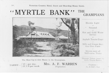 Halls Gap & Grampians Historical Society
Photograph - B/W, C 1918
Information supplied with accommodation details Victorian Country Hotel, Guest and Boarding House Guide "Myrtle Bank" The Grampians Electric Light, Sewered, Hot and Cold Water Service, Asphalt, Tennis Court, Milk and Cream from our own farm, Motors meet all melbounre Trains, The Most Up-to-date house in the Grampians, Through Tickets issued by Govt. Tourist Bureau, Telephone : No. 1 Halls Gap Tariff: 12/ per day L 3/3/0 per week. Proprietress Mrs A. F WarrenGuest House and grounds with Tariff information and servicesQuality paper made in Germanyaccommodation, guesthouses, myrtlebank -
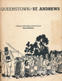 Eltham District Historical Society Inc
Book, Queenstown / St Andrews: A history of the district and the school by Nancy Mortimer, 1983
Local history book published on the occasion of the 125th anniversary of St Andrews Primary School 1983. Contents: Forward, Headmaster's message, early days at St. Andrews, School No 128: St Andrews, Why should children practice temperance, 3594 Queenstown North, 933 Smith's Gully, 1737 Smith's Gully, The Church of St Andrews, Post Office, St Andrew's Hotel. Includes some photos and illustrations including reproduced original documents. Includes list of head teachers 1858-1983. Includes names of pupils 1983.This book is significant in that not only does it traces the development of St Andrews Primary School and of education in the area but it also gives an insight into the people and their community.Softcover, 109 pagesqueenstown, st andrews, education, st andrews primary school -
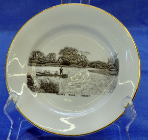 Orbost & District Historical Society
souvenir plate, Between 1925 and 1941
Illustration on plate is a family fishing party aboard the "Ripple" built by George Matthew Winchester. Shows Ethel (mother) with Lindsay Smooker on her knee. Harry, Elsie, Anita and H. Hermann about 1941. The Winchesters lived in Marlo and built boats near the Marlo hotel. The "Ripple" built by George Winchester at the age of 18 years was the first boat built by him. It was built in 1908. It has been noted in a profile of George Winchester done by his Daughter Olive Hunt (née Winchester) that was completed one year before her death in 2002.The Winchester family is a prominent local family.The Winchesters lived in Marlo and built boats near the Marlo hotel. This item is an example of a souvenir item made especially for Orbost.Very small white souvenir plate. Gold-rimmed with black illustration of people in a boat on the Snowy River.Front-Snowy River Orbost Back-Melba Bone China Guaranteed Made in Englandplate souvenir snowy-river orbost melba-china -
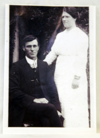 Orbost & District Historical Society
framed photograph
William Garnet Macalister's parents, Thomas Mewburn and Ruth Hannah Macalister, owned and operated "Orbost House". William Garnet Macalister was born at Bairnsdale in 1884 and at Sale, aged 72, in 1958. He operated a line of coaches conveying passengers and parcels from Orbost to Cabbage Tree Creek, Club Terrace, Cann River and surrounding districts. The service departed from Orbost on Wednesdays and from the Cann River Hotel on Fridays. He was also Orbost's first milkman. He married Ethel Roda SAYERS in 1909. ( Information from John Phillips) The Macalister family is associated with early Orbost.A copy of a b/w 1920 wedding photograph. It is in a wooden frame. The photo is of a groom, William Garnet Macalister, seated with his bride, Ethel, Roda Macalister, standing on his right an arm at his back.Handwritten on back - WILLIAM GARNET MACALISTER - SON OF THOMAS MEWBURN MACALISTER RUTH HANNAH MACALISTER OF ORBOST HOUSE B 1910 died 2003 (93 years old) ETHEL RODA MACALISTER (nee SAYERS)macalister-william macalister-ethel orbost-house -
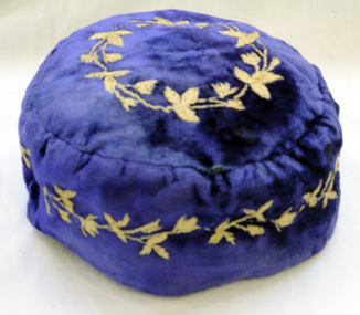 Orbost & District Historical Society
smoking cap, late 19th century
Smoking Caps are caps worn by men while smoking to stop the hair from smelling of smoke. They also kept the head warm. They were popular in the period 1840-1880, usually worn by gentlemen in the privacy of their home. This beautiful velvet smoking cap was worn by James Stirling who was the first settler to occupy land in the Marlo township. James stirling arrived in Victoria from Scotland in 1842.He took over Corringle Station (Ewing's Marsh). His son James stirling later established theMarlo Hotel. (Read more in Mary Gilbert’s book)Smoking accessories like this cap were popular through the mid-to-late nineteenth century to prevent the smoker's hair from absorbing the smell of tobacco smoke and were often worn with smoking jackets. The design, with its elaborate embroidery shows an aspect of Victorian material culture and reflects the nineteenth-century love of 'Oriental' style. . A domed shaped smoking cap of blue velvet .It is lined with silk. The tops and sides are embroidered with tan coloured leaves. head-coverings stirling-james smoking-cap -
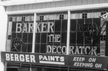 Stawell Historical Society Inc
Photograph, Barker the Decorator Leadlight Advert in Upper Main Street Stawell. c 1984
Photographs of "Barker The Painter" a business that operated in Stawell for 80 years. The black and white photo is simple of the leadlight in the top section of the front window. The Second photo, the building location in Upper Main Street Stawell beside the Albion Hotel. The file also contains an article from Stawell Times - News. Tuesday March 4, 1986, p.13. regarding the closing of the business. Mr. W. C. Barker started the business and it was continued for many years by his two daughter and son till it closed in 1986. The building is now replaced by a new building.Two photographs of "Barker The Painter" a business that operated in Stawell for 80 years. One photograph is a detail of the leadlight advertisement. The other a colour photograph of the building.Barker The Decorator - Berger Paints - Keep on Keeping onstawell business -
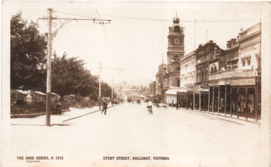 Ballarat Tramway Museum
Postcard, Rose Stereograph Co, Sturt St Ballarat Vic, c1916
The photo is of Sturt St showing Town Hall Ballarat Vic, looking east towards Grenville St from Doveton St. An ESCo tram is in the far distance. In the view are Stansfield and Smith, Snows, and the Bucks Head Hotel. On the left can be seen Shoppee's Square marketplace tents. Photo is very similar in location to item 7364, a later version of this Rose Series photo with the same number 1712. Wal Jack has written on the rear "One of the Sebastopol type of trams (cross seater with centre aisle) about 1916, photo from Doveton St" Demonstrates a postcard of Sturt St south side.Postcard Black and white - Rose Series No 1712 - divided back with the rose symbol, publisher details on the left side and that it is a "Real" photograph.See image 2 for Wal Jack's notes.sturt street, ballarat, tramways, esco, town hall, shoppee's square -
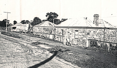 Bendigo Historical Society Inc.
Document - Harvey Town Eaglehawk, Bendigo, Victoria, 1958
Harvey Town was once a large mining area with its own shops, churches and hotels. The four remaining stone cottages were built by the Harvey Family between the 1850s and the 1870s. They were obviously the most substantial buildings in the area at the time. Three of the cottages have been classified as a group by the National Trust and the citation describes them as follows: A group of three simple sandstone cottages built by the Harvey Family of Cornish stonemasons in about 1875. The cottages are all of a very simple design with small windows and no ornamentation. They are in good condition and inhabited at the present time.Numerous photo copies of stone cottages with notes on the location and history.history, national trust bendigo collection, bendigo, harvey town, eaglehawk -
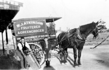 Surrey Hills Historical Society Collection
Photograph, Delivery cart outside Mr & Mrs W. J. Atkinsons's greengrocery business near the corner of Elgar and Whitehorse Roads, c1930
Delivery cart of Mr & Mrs W J Atkinson’s greengrocery business and general store near the corner of Whitehorse and Elgar Roads, c 1930. Emma Uebergang and William James Atkinson married in 1930. They ran a mixed business in Whitehorse Road from 1926-1952. Stock included fruit and vegetables, sweets and some groceries. With Mr Atkinson is Albert Cunnington who in about 1930 helped with deliveries. To the left can be seen Whitehorse Road as it approaches the shopping centre and over the back of the horse can be seen the White Horse Hotel. This was demolished in 1938.A black and white photograph of a horse and delivery cart identified as W. J. Atkinson Fruiterer and Greengrocer, 33? Whitehorse Road Box Hill.land transport, carts and wagons, horse drawn vehicles, fruiterer and greengrocer, whitehorse road, elgar road, mont albert, box hill, mr william james atkinson, mrs emma gertrude atkinson, miss emma gerte uebergang, mr albert cunningham -
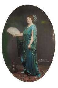 City of Greater Bendigo - Civic Collection
Photograph - Portrait, Vincent Kelly, Mrs M.G. Giudice Mayoress 1922 - 24, c 1924
Prior to the election of female Councillor's and Mayors, the Mayoress role as wife of the Mayor, was one of the few ways women could officially undertake civic duties. Mayoress's made important contributions through their charity work, even stepping in on occasions to undertake Mayoral duties. Mayoress Giudice was born Beatrice Annie Harvey in Bendigo and became the first Girl Guide Commissioner in Bendigo. The Giudice family was associated with the Lyric Theatre, the Bendigo United Breweries, Shamrock Hotel and the Bendigo Lyric Photo Plays. Mrs Giudice died in 1980, aged 95 years.Framed, oval photographic portraits with convex glass and print, created using a collodion wet plate process. Hand coloured detail.Mrs M.G Giudice / Mayoress 1922 -24.sandhurst, bendigo, mayoress, mayor, vincent kelly, studio photography, portrait, giudice, beatrice annie harvey, lyric theatre bendigo, girl guides, mayor giudice, city of greater bendigo portraits