Showing 126720 items
matching main-road
-
 Melton City Libraries
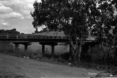
Photograph, Bridge Road Bridge, Unknown
The Bridge Road Bridge built in 1913 by Sir John Monash for the Shire of Melton. It was built to provide railway station access to the new farming areas.Black and white photo of the bridgetransport, council -
 Ringwood and District Historical Society
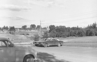
Photograph, Looking from parking area in front of Parkwood High School towards Wonga Road over new subdivision, North Ringwood, 1981
Written on back of photograph, "24.4.81 Looking from parking area in front of Parkwood High School towards Wonga Road over new subdivision. In the area seen there are six new courts under construction. Three months ago there was nothing there." -
 Pyrenees Shire Council
painting, The Firs, Raglan Road, Beaufort by Sue Jarvis, 1993
significant as a work of art by local Pyrenees artist, locally significant to the Central Highlands Region of Victoria as a representation of local landscape and/or culture painting of homestead"Signed: JARVIS Verso: THE FIRS, RAGLAN ROAD, BEAUFORT SUE JARVIS 1993 55 BRANTOME ST GISBORNE 3437 PH 054282674 OR BLACKWOOD LANE STUDIO 24 BLACKWOOD LANE GENBROOKN3738 PH 059 681 567 $525" -
 Ringwood and District Historical Society
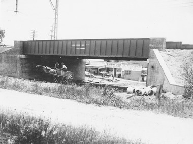
Photograph, Maroondah Highway Central, Ringwood. Construction of Warrandyte Road railway viaduct, 1923
Black and white photograph (2 copies)Typed below photograph: "Construction of Warrandyte Road railway viaduct, Ringwood - 1923." Maroondah Highway shops in background later redeveloped as the site of Safeway supermarket then Officeworks office supplies outlet, prior to Eastland Shopping Centre expansion in 2015. -
 Melbourne Tram Museum
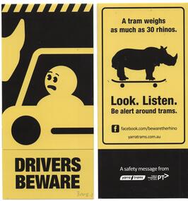
Pamphlet, Yarra Trams, "Drivers Beware", "Getting Around Safely on Trams", "Travel Happy Share the Road", "Beware of Sudden Stops", c2013 to 2015
Set of four pamphlets folded to DL size regarding safety on trams, public transport. .1 - "Drivers Beware" - asking motorists to beware of trams, uses the Rhino image - 30 Rhinos. .2 - "Getting Around Safely on Trams" = 3 fold DL - giving safety tips for travelling on trams - dated May 2013. .3 - "Travel Happy Share the Road" - 3 fold DL - VicRoads - giving advice on sharing the road for all types of transport. .4 - "Beware of Sudden Stops" - hanging pamphlet - advising passengers to hang on and beware around trams - features the Rhino image. Have the Yarra Trams, Public Transport Victoria or VicRoads images and logos.trams, tramways, safety, yarra trams, rhinos, ptv, vicroads -
Whitehorse Historical Society Inc.
Map, Nunawading Shire, 1892
Photocopy of an enlargement of map of Shire of Nunawading showing landowners in 1892.Photocopy of an enlargement of map of Shire of Nunawading showing landowners in 1892. Covers Middleborough Road to Ringwood boundary. One map (Blackburn) from north of Whitehorse Road to Highbury Road, 2nd map (Mitcham) Bulleen to south of Canterbury Road; 3rd map Whitehorse Road to Highbury Road.Photocopy of an enlargement of map of Shire of Nunawading showing landowners in 1892. maps, shire of nunawading, blackburn, blackburn south, nunawading, forest hill, vermont, mitcham, vermont south -
 Eltham District Historical Society Inc
Negative - Photograph, J.A. McDonald, Eltham, Haldane Road, Mar. 1961
Dr Donald Thomson's gate and entrance to his property 'Worlingworth' after flooding in March 1961 "Worlingworth", Eltham, was the home of noted anthropologist the late Professor Donald Thomson and his wife Dorita. The entrance gate on Banoon Road is located at the bottom of the hill opposite Haldane Road. The flooding issues were regularly reported to Council following heavy rain. Google Street View Feb 2014 https://goo.gl/maps/SGjsJAAEdjQXgo5V9Record of various Shire of Eltham infrastructure works undertaken during the period of 1952-1962 involving bridge and road reconstruction projects, sometimes with Eltham Shire Council Project Reference numbers quoted. It was during this period that a number of significant improvements were made to roads and new bridges constructed within the shire that remain in place as of present day (2022). In many situations, the photos provide a tangible visible record of infrastructure that existed throughout the early days of the Shire. The album was put together by or under the direction of the Shire Engineer, J.A. McDonald.infrastructure, shire of eltham, 1961-03, flood damage, haldane road, prof donald thomson, worlingworth -
 Eltham District Historical Society Inc
Photograph, Odyssey House Victoria, 28 Bonds Road, Lower Plenty, 6 March 1990
Odyssey House drug rehabilitation centre in Bonds Road, Lower Plenty is a distinctive landmark, especially when viewed from across the Yarra at Templestowe. It was built in the 1950’s as a seminary for the Blessed Sacrament Fathers. Because of the poor and circuitous road access, a suspension footbridge was built across the river. As well as providing easy access for the priests residents of Templestowe could attend services at the seminary. The bridge is now part of the Yarra Trails system.Colour photographlower plenty, bonds road, odyssey house -
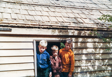 Eltham District Historical Society Inc
Photograph, Peter Bassett-Smith, Cottage, Metery Road, Eltham, 1964, 1964
Colour photograph of a cottage in Metery Road, Eltham before demolition in 1964. In the window opening L-R Johnathon, James and Robin Bassett-Smith, aged 10, 7 and 12; openers of time capsule please note in Year 2035.includes Johnathan, James and Robin Bassett-Smithhouses, metery road, bassett smith -
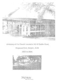 Ringwood and District Historical Society
Book, A History of the Church Located at 44-44 Dublin Road, Ringwood East, 2014
Draft of A History of the Church Located at 44-44 Dublin Road, Ringwood East, 3134 from 1925 to 2014 covering Ringwood East Baptist Church from 1929 to 1989, Ringwood Christian Family Centre from 1990 to 1999 and Maroondah Family Church from 2000 to 2014 -
Port Melbourne Historical & Preservation Society
Postcard - Swallow & Ariell promotion, On the Road
"On the Road" Coloured postcard, front shows a bullock team and dray in front of a bark hut. Large gum tree on right and hills behind. Back shows Swallow & Ariell's renowned biscuits and cakes, pure jams and canned fruits. Plum puddings and Australian seeded raisins etc. are the bestindustry - food, swallow & ariell ltd -
 Whitehorse Historical Society Inc.
Photograph, Property at 347-349 Mitcham Road, Mitcham, owned By Methodist Church, C.1988
Coloured photo of Property, 347-349 Mitcham Road, Mitcham, owned by Methodist Church (now Uniting Church) and leased to Garage till September, 1982.Office building later built on site. In the background of the photo, the timber and steel roof building is the Mitcham Memorial Hall (now demolished).uniting church mitcham, mitcham road mitcham -
 Whitehorse Historical Society Inc.
Photograph, Blackburn Road looking south from the railway gates - 1920
Used by in , 'Blackburn - A picturesque History' by Robin Da CostaBlack and white photograph of Blackburn Road looking south from the railway gates - 1920. see page 32 0f Da costa book. Also see NP41 dated 1914.|Catalogued and entered in January 2008; appears not to have been entered earlier. Cataloguer, C. Paulblackburn road blackburn -
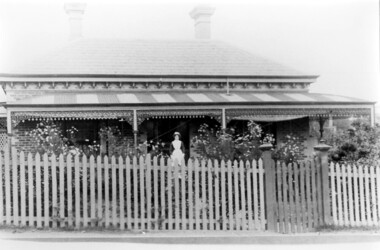 Surrey Hills Historical Society Collection
Photograph, Dr Blakie's home and surgery, 171 Union Road, Surrey Hills
The photo would have been taken prior to 1913 as Dr Blakie moved across the road to 174 Union Road to a purpose-built home/surgery designed by architect Arthur Plaisted. He practised at 171 Union Road joining or taking over from Dr Percy Liddle in 1905. The property was rented from the Zeplin family who built the house in 1890, which was known as 'Edgeware', and originally owned all the land bound by the railway, Union Road, Wilson Street and Montrose Street. in the 1920s to 1930s. 1906 became the home of Dr James Blakie, surgery was to the left of house. In 1912 Blakie had house built opposite (now Medical Centre). In 1920s-30s 'Edgeware' became Surrey Hills Police Station. Family details: James Blakie was born in New Zealand to a farming family of Scottish origin. He trained at Otago University with additional study at Cambridge. He married Catherine Miller Martin in 1906. They had 4 children: Geoffrey Noel (1906-1955); Raymond James (1907-1989); Theodore (1913-1913) and a daughter.Black and white photo of a Victorian style home with a slate roof, 2 chimneys, and a striped corrugated iron front veranda to 2 sides with decorative iron fretwork. It has a picket fence and an established garden with a central path leading to the front door. A woman, identified as Nurse Jones, is standing on the veranda.victorian style, homes, edgeware, house names, union road, montrose street, surrey hills, police station, zeplin family, professor zeplin, doctors, medical services, nurses, nurse jones, dr james landells blakie, dr percy liddle, mrs catherine miller blakie, raymond james blakie, geoffrey noel blakie, surrey hills police station, arthur plaisted, architects, edgeware, house names, 1890-1900 -
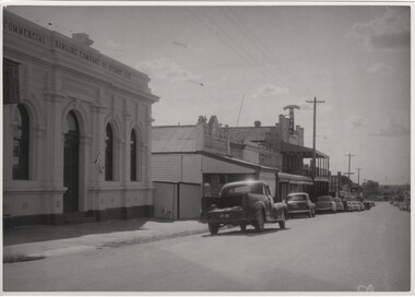 Rutherglen Historical Society
Image, Herald & Weekly Times, 1954
Photograph features the Commercial Banking Company of Sydney Ltd (Now the NAB) and the Rutherglen Hotel (Now Poachers Paradise Hotel)Black and white photograph of Main Street, Rutherglen, looking west from the High Street intersection.Written on back of photo: "In W.T. Mar 10. 1954 page 54. The Main Street, Rutherglen Vic" At top right on back: "3/6" On back rubber stamp with copyright information.main street rutherglen, cbc bank, nab, rutherglen hotel, poachers paradise hotel -
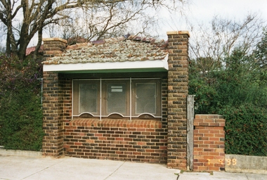 Stawell Historical Society Inc
Photograph, Brick Ticket Box at Central Park c 1937 -- Coloured
Brick Ticket Box built around c 1937. This photo of the Ticket Box is located in Lower Main St, and on the right side of main gates to Central Park.Colour photo of Brick Ticket Box, Lower Main St, at Central Park located right side of main gates. Photo taken in 1999. Photo shows the tile roof with moss growing all over the tiles. The three windows are covered with a white security mesh.stawell central park -
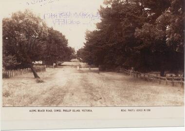 Phillip Island and District Historical Society Inc.
Photograph, Early 20th Century
One of 20 photographs/postcards donated by Mary KarneySepia photograph copy of a postcard. Beach Road, Cowes with fences and trees lining the road."Along Beach Road, Cowes, Phillip Island, Victoria." "Real Photo Series M 1258"beach road, cowes phillip island, cowes phillip island, mary karney -
 Eltham District Historical Society Inc
Negative - Photograph, J.A. McDonald, Heidelberg-Kinglake Road, Sep 1959
Job 56M430 Contractor Hone Just south of east abutment and access road to house showing block in table drain and wash towards Diamond CreekRecord of various Shire of Eltham infrastructure works undertaken during the period of 1952-1962 involving bridge and road reconstruction projects, sometimes with Eltham Shire Council Project Reference numbers quoted. It was during this period that a number of significant improvements were made to roads and new bridges constructed within the shire that remain in place as of present day (2022). In many situations, the photos provide a tangible visible record of infrastructure that existed throughout the early days of the Shire. The album was put together by or under the direction of the Shire Engineer, J.A. McDonald.infrastructure, shire of eltham, bridge construction, 1959-09, heidelberg-kinglake road, road construction -
 Eltham District Historical Society Inc
Negative - Photograph, J.A. McDonald, Kangaroo Ground-Queenstown Road, Aug. 1960
Beginning of roll of film Most likely at (Kangaroo Ground-St Andrews Road) “Rymers” Corner – shifting Hawthorn hedges on Tompkins property August 1960Record of various Shire of Eltham infrastructure works undertaken during the period of 1952-1962 involving bridge and road reconstruction projects, sometimes with Eltham Shire Council Project Reference numbers quoted. It was during this period that a number of significant improvements were made to roads and new bridges constructed within the shire that remain in place as of present day (2022). In many situations, the photos provide a tangible visible record of infrastructure that existed throughout the early days of the Shire. The album was put together by or under the direction of the Shire Engineer, J.A. McDonald.infrastructure, shire of eltham, 1960-08, garden hill, kangaroo ground, kangaroo ground-queenstown road, kangaroo ground-st andrews road, rymers corner -
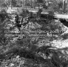 Eltham District Historical Society Inc
Negative - Photograph, J.A. McDonald, Henley Road at Watsons Creek, Mar. 1961
Henley Road at Watsons Creek Looking easterly along new alignment, 22 March 1961 C. Browns Excavator Contractor Wolf Cr PellingRecord of various Shire of Eltham infrastructure works undertaken during the period of 1952-1962 involving bridge and road reconstruction projects, sometimes with Eltham Shire Council Project Reference numbers quoted. It was during this period that a number of significant improvements were made to roads and new bridges constructed within the shire that remain in place as of present day (2022). In many situations, the photos provide a tangible visible record of infrastructure that existed throughout the early days of the Shire. The album was put together by or under the direction of the Shire Engineer, J.A. McDonald.infrastructure, shire of eltham, 1961-03, bend of islands, cr. charis pelling, henley road, henley road bridge, kangaroo ground, oxley bridge, watsons creek, w.e. wolf, bridge construction, road construction -
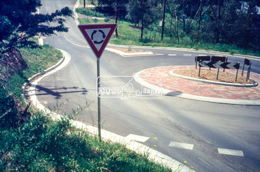 Eltham District Historical Society Inc
Slide - Photograph, Ryans Road, Eltham, c.1989
Ryans Road was reconstructed and sealed to the north of Kerrie Crescent in 1983. Roundabout and southern reconstruction added later. This photo is probably shortly after construction of roundabout.35mm colour positive transparency Mount - Black and Whiteeltham, infrastructure, kerrie crescent, roundabout, ryans roads -
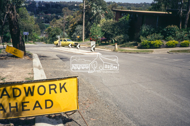 Eltham District Historical Society Inc
Slide - Photograph, Ryans Road, Eltham, c.1989
Ryans Road was reconstructed and sealed to the north of Kerrie Crescent in 1983. Roundabout and southern reconstruction added later. This photo is probably shortly after construction of roundabout.35mm colour positive transparency Mount - Black and Whiteeltham, infrastructure, ryans roads, burd street, meruka drive -
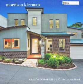 Greensborough Historical Society
Advertising Leaflet, 11/171 St Helena Road Greensborough, 17/05/2018
11/171 St Helena Road Greensborough. 3 bedroom town house. Sold May 2018 for $750,000. Previous sales: July 2009 for $410,000.Real Estate advertising leaflet,1 sheet folded into 4 pages, printed in colour both sides.st helena road greensborough -
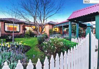 Greensborough Historical Society
Advertising Leaflet, 53 Airlie Road Montmorency, 25/11/2012
53 Airlie Road Montmorency. 4 bedroom home, sold December 2012 for $645,000. Previous sales: February 1999 for $235,000 and March 1997 for $124,000.Real estate advertising leaflet, 1 sheet, printed in colour both sidesairlie road montmorency -
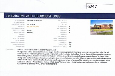 Greensborough Historical Society
Advertising Leaflet, Barry Plant Greensborough, 88 Delta Road Greensborough, 11/10/2018
Real estate advertisement for 88 Delta Road Greensborough, a 3 bedroom house. Originally listed by Barry Plant, this property was sold in November 2018 for $680,000. Real estate advertisement black text and colour photographdelta road greensborough -
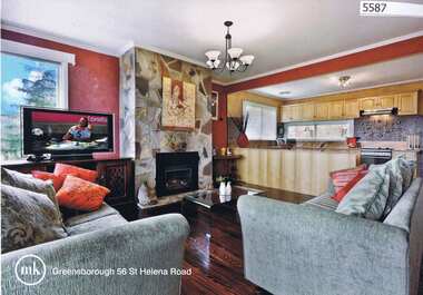 Greensborough Historical Society
Advertising Leaflet, 56 St Helena Road Greensborough, 04/09/2012
56 St Helena Road Greensborough, 3 bedroom home, sold September 2012 for $480,000; sold in August 2013 by Ray White Greensborough for $485,000Real Estate advertising leaflet, 1 sheet, printed both sides in colourst helena road greensborough -
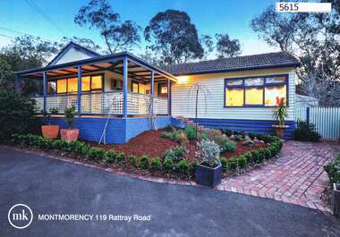 Greensborough Historical Society
Advertising Leaflet, 119 Rattray Road Montmorency, 16/10/2010
119 Rattray Road Montmorency. 3 bedroom home, auctioned 16 October 2010, sold November 2010 for $550,000; sold February 2018 for $931,500Real estate advertising leaflet, 1 sheet, printed in colour both sidesrattray road montmorency -
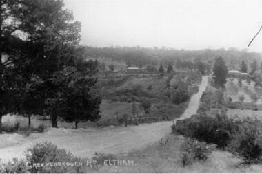 Greensborough Historical Society
Photograph - Digital image, Greensborough Road, 1900s
An early photograph named as Greensborough Road, Eltham. This was later known as Bridge Street - first reference to same is in The Age 27 November 1906, page 12.Digital copy of black and white photographgreensborough road -
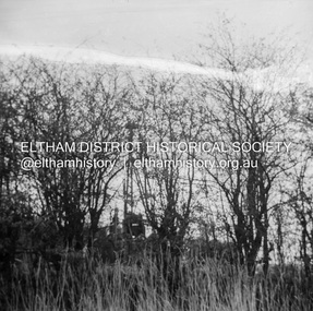
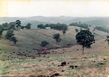 Eltham District Historical Society Inc
Photograph, Possibly the Bassett-Smith property at Menzies Road, Kangaroo Ground where the society would go for picnics
Possibly the Bassett-Smith property at Menzies Road, Kangaroo Ground where the Society would go for picnics. Cross Ref: 01706 (print) and 01800 (neg)2 colour photographspeter bassett smith, kangaroo ground, yarra river, sheds, menzies road -
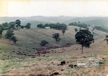 Eltham District Historical Society Inc
Photograph, Possibly the Bassett-Smith property at Menzies Road, Kangaroo Ground where the society would go for picnics
Possibly the Bassett-Smith property at Menzies Road, Kangaroo Ground where the Society would go for picnics. Cross Ref: 01706 (print) and 01800 (neg)2 colour photographspeter bassett smith, kangaroo ground, yarra river, sheds, menzies road