Showing 6234 items matching "new road"
-
 Kew Historical Society Inc
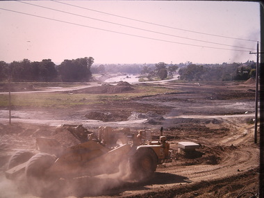
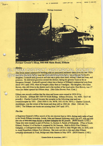
Photograph - Construction of the Eastern Freeway (F19), Ron Setford, March 1972
Ron Setford and his wife Grace Setford lived in Tanner Avenue, East Kew, from c.1946 to c.1995. A keen photographer, he recorded the changing face of Kew over a 20 year period. Apart from 30 photographs of built structures and places in Kew dating from 1960 and 1961, 145 of his 35mm colour slides chronicle the development of the F19 (later renamed Eastern) Freeway through the Yarra Valley in Kew over a five year period from c.1972 to c.1977. This important collection was donated to the Society by his granddaughter in 2025.This collection of 175 35mm slides is of local and statewide significance, owing to its subject matter, particularly the major development of road transport infrastructure during the 1970s with the construction of the Eastern Freeway. The photographer also took care to annotate and date most of his slides which enable the researcher to pinpoint temporal and spatial locations.Panoramic view of the Yarra Valley in March 1972 showing the early stages of the construction of the F19 (Eastern) Freeway. The photo shows the construction of an embankment to contain the new river course of the Yarra."Eastern Freeway / New river course preparing for embankment / Mar 72"ron setford, eastern freeway, f19 freeway -
 Bendigo Historical Society Inc.
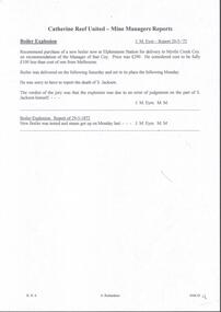
Document - MINING REPORTS - CATHERINE REEF UNITED MINE MANAGERS REPORTS
Handwritten notes, with typed transcript of same, on Catherine Reef United Mine Manager, J. M. Eyre Report 20/5/'72. Recommends the purchase of a new boiler. S. Jackson killed in a boiler explosion which the jury said was due to an error of judgement on his part. Recommendations, re New Winding Engine and Poppet Legs by Rbt. Coakes 18th May, 1905. Truck road from the shaft to the battery. Recommendation to call for tenders for a new changing house and a blacksmith shop. Reports about boilers, ropes, cleaning of machinery, testing of brakes, slack coal from the Powlett North Woolamai Collieries, crushings, number of batteries, low wood supply and a visit to the New Moon & South New Moon which are burning the Powlett slack coal. Albert Richardson Collectiondocument, gold, mining reports, mining reports, catherine reef united mine managers reports, j m eyre, myrtle creek coy, s jackman, rbt coakes, great northern co, virginia co, mr roberts, mr harkness, mr mcgrath, ernest mueller, roberts & sons, mr bennett, mr abrahams, mr sluyterman, j langdon, electrical supply coy, smiths, powlett north woolamai collieries, m j gwatkins, new moon, south new moon -
![Photograph - Construction of the F19 [Eastern Freeway], Ron Setford, May 1976](/media/collectors/550653872162f11fb04854aa/items/6815b03d8b3331834378a6c9/item-media/6815b0708b3331834378ab4c/item-fit-380x285.jpg) Kew Historical Society Inc
Kew Historical Society IncPhotograph - Construction of the F19 [Eastern Freeway], Ron Setford, May 1976
Ron Setford and his wife Grace Setford lived in Tanner Avenue, East Kew, from c.1946 to c.1995. A keen photographer, he recorded the changing face of Kew over a 20 year period. Apart from 30 photographs of built structures and places in Kew dating from 1960 and 1961, 145 of his 35mm colour slides chronicle the development of the F19 (later renamed Eastern) Freeway through the Yarra Valley in Kew over a five year period from c.1972 to c.1977. This important collection was donated to the Society by his granddaughter in 2025.This collection of 175 35mm slides is of local and statewide significance, owing to its subject matter, particularly the major development of road transport infrastructure during the 1970s with the construction of the Eastern Freeway. The photographer also took care to annotate and date most of his slides which enable the researcher to pinpoint temporal and spatial locations."Old bridge works MMBW, New bridge works CRB / Main bridges over Yarra River / Fairfield - Kew"ron setford, eastern freeway, f19 freeway -
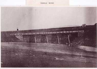 Clunes Museum
Photograph, PURCELL, ROGER, 1994
... . A WELL BESIDE THE COTTAGE IS STILL NEAR THE ROAD. BESIDE THE NEW.... A WELL BESIDE THE COTTAGE IS STILL NEAR THE ROAD. BESIDE THE NEW ...ORIGINAL PHOTOGRAPH OWNED BY MRS. LENA COOK OF CASTLEMAINE RD. CRESWICK.. THE PHOTOGRAPH WAS TAKEN LOOKING SOUTH WEST, THE SMALL COTTAGE SOUTH EAST OF HOLDING KNOWN AS 'STRAINS' ON THE CORNER OF BALLARAT AND COOK'S ROADS, MAY HAVE BEEN THE TOLL HOUSE. A WELL BESIDE THE COTTAGE IS STILL NEAR THE ROAD. BESIDE THE NEW TOURELLO BRIDGE..1 FRAMED PHOTOGRAPH OF TOURELLO BRIDGE ON BALLARAT RD. OVER COGHILLS CREEK. .2 BLACK & WHITE PHOTOGRAPH (COPY) .3 BLACK AND WHITE COPY OF ABOVE PHOTOGRAPHlocal history, photography, photographs, bridges -
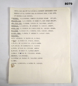 Bendigo Military Museum
Document - COMMITTEE BDSC 1978, Bendigo District Servicemen's Club, April 1978
This election is possibly the new Committee to manage the Bendigo & District Servicemen's Club in Havilah Road. Cat No 8080 Committee meeting talks about getting ready for the opening of the facility to members. President W.B. Nicholls refer Cat No 8073P. Snr Vice President D.J. Paterson refer Cat No 8073P. Committee member David Patterson refer Cat No 8070.Document, paper all print in black listing the complete Committee of the Bendigo & District Servicemen's Club, has names, position, address and phone number. One name is unreadable due to damage. "Office Bearers of the Bendigo & District Servicemen's Club elected at the meeting held on Thursday 20th April 1978 at Memorial Hall Bendigo".brsl, smirsl, bdsc, committee -
 Eltham District Historical Society Inc
Document - Property Binder, 846 Main Road, Eltham
Photocopy Newspaper Article: An old grain store faces a new role; Diamond Valley New, Tuesday, February 11, 1986, p13 (donated Geoff Watt28/2/2023). Photocopy Letterhead: Watt + Partners Pty Ltd, Architecture, Project Management (donated Geoff Watt28/2/2023). Photocopy Heritage Assessment: Former Grocer's Shop, 846-848 Main Road, Eltham by Graeme Butler & Associates, 1997. Newspaper article: Diamond Valley News, 16 July, 1997 Funeral parlour gets permit. Newspaper advertisement: Leader Associated Newspapers, Eltham Centenary Supplement, March 30, 1971, Eltham Produce Storemain road, eltham, property, shops, businesses, charles cockroft, edna brown, don brown, c r nicholls, josiah holloway, john holloway, samuel holloway, robert galagher, john wright, anne hunniford, a g cole, eltham produce store -
 Bialik College
Mixed media (series) - Sites & Premises: fundraising appeals and plans for development
1990s, 2000s, 1980s, buildings, development, planning, shakespeare grove, elc, 1970s1990s, 2000s, 1980s, buildings, development, planning, shakespeare grove, elc, 1970s -
 Kew Historical Society Inc
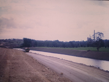
Photograph - Construction of the Eastern Freeway (F19), Ron Setford, November 1972
Ron Setford and his wife Grace Setford lived in Tanner Avenue, East Kew, from c.1946 to c.1995. A keen photographer, he recorded the changing face of Kew over a 20 year period. Apart from 30 photographs of built structures and places in Kew dating from 1960 and 1961, 145 of his 35mm colour slides chronicle the development of the F19 (later renamed Eastern) Freeway through the Yarra Valley in Kew over a five year period from c.1972 to c.1977. This important collection was donated to the Society by his granddaughter in 2025.This collection of 175 35mm slides is of local and statewide significance, owing to its subject matter, particularly the major development of road transport infrastructure during the 1970s with the construction of the Eastern Freeway. The photographer also took care to annotate and date most of his slides which enable the researcher to pinpoint temporal and spatial locations."New river course / Latrobe golf club across river / Nov 72"ron setford, eastern freeway, f19 freeway -
 Kew Historical Society Inc
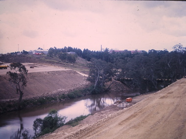
Photograph - Construction of the Eastern Freeway (F19), Ron Setford, November 1972
Ron Setford and his wife Grace Setford lived in Tanner Avenue, East Kew, from c.1946 to c.1995. A keen photographer, he recorded the changing face of Kew over a 20 year period. Apart from 30 photographs of built structures and places in Kew dating from 1960 and 1961, 145 of his 35mm colour slides chronicle the development of the F19 (later renamed Eastern) Freeway through the Yarra Valley in Kew over a five year period from c.1972 to c.1977. This important collection was donated to the Society by his granddaughter in 2025.This collection of 175 35mm slides is of local and statewide significance, owing to its subject matter, particularly the major development of road transport infrastructure during the 1970s with the construction of the Eastern Freeway. The photographer also took care to annotate and date most of his slides which enable the researcher to pinpoint temporal and spatial locations."Temporary across bridge at rear / New bridge embankments / Kew - Fairfield"ron setford, eastern freeway, f19 freeway -
 Kew Historical Society Inc
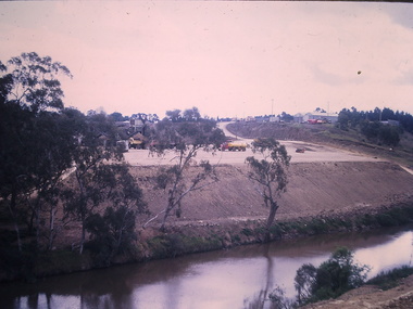
Photograph - Construction of the Eastern Freeway (F19), Ron Setford, November 1972
Ron Setford and his wife Grace Setford lived in Tanner Avenue, East Kew, from c.1946 to c.1995. A keen photographer, he recorded the changing face of Kew over a 20 year period. Apart from 30 photographs of built structures and places in Kew dating from 1960 and 1961, 145 of his 35mm colour slides chronicle the development of the F19 (later renamed Eastern) Freeway through the Yarra Valley in Kew over a five year period from c.1972 to c.1977. This important collection was donated to the Society by his granddaughter in 2025.This collection of 175 35mm slides is of local and statewide significance, owing to its subject matter, particularly the major development of road transport infrastructure during the 1970s with the construction of the Eastern Freeway. The photographer also took care to annotate and date most of his slides which enable the researcher to pinpoint temporal and spatial locations."New bridge approach / Embankments / Kew - Fairfield"ron setford, eastern freeway, f19 freeway -
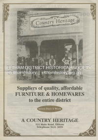 Eltham District Historical Society Inc
Document - Property Binder, 931 Main Road, Eltham
Present day location of Nongkhai Thai Eltham restaurant Formerly the location of: Luther Haleys Bakery and General Store (Sep 1902-1917) - Hayley built this store, which was the first store erected in the present-day Eltham shopping district Hannah Lloyd's General Store (1917-c.Feb 1920) Various owners Staff's General Store (c.1939-Feb 1965) then demolished Ray Staff Eltham Big Star Food Centre (c.1965-1967) Eltham Big Star Food Centre (Staffs new building c.1965-1967) A Country Heritage Furniture and Homewares (?-2006) Newspaper advertisement: Leader Associated Newspapers, 100 Years of News Special Edition, August 27, 1997, p6; A Country Heritage Newspaper advertisement: Diamond Valley Leader, 4 September 2006, Closing Down Sale, A Country Heritage In February 1965, Staffs Railway Store, the oldest business premises in the Eltham shopping district was demolished. Formerly a self-service grocery, restaurant and electrical repair shop, the building for many years housed Eltham’s only ‘family’ grocer and feed store. Earlier it had appeared to have been the town’s bakery. The building had been purchased in late March 1939 by Mr Eric N. Staff. At the time of E.N. Staff’s purchase there were huge bakers’ ovens located at the rear and the building also had a well and four toilets for employees. When the ‘pictures’ came to Eltham with the opening of the Eltham Public Hall across the road in 1941, Mr E.N. Staff extended the business and opened a milk bar and sweet shop. Further extensions re-established the tea rooms of days gone by. Mr E.N. Staff conducted business for about 15 years before handing over the reins to his son, Ray Staff. When his son Ray took over, the milk bar and tea rooms were closed for several years but the milk bar and was later re-opened and subsequently became a greengrocers and later again, a restaurant. The tea rooms section was converted to an electrical repair shop about 1955. Electoral Roll records for 1967 record Raymond Charles Staff at 929 Main Road, Eltham, grocer, and in 1968 at Lot 4, Hillcrest Avenue, Eltham, taxi truck operator. Staff’s store appears to have occupied 929-933 Main Road and the Eltham Big Star Food Centre was centred around 931 Main Road. It would appear that Ray continued to run the business for approximately two years after the original store was demolished and a new supermarket was built. Today, 931 Main Road is the Nongkhai Thai Restaurant and is precisely where the original Staffs store stood. Even though the facade has been modified at eye level with new larger windows, the upper facade is identical to that of the new Eltham Big Star Food Centre of 1965/66. But how did the original building, the oldest premises in the 1965 era shopping centre come about? On August 12th, 1902 at the Eltham Courthouse, appearing before T. Smallman, Esq,. Police Magistrate, and Messrs. W. Duncan and W.J. Taylor, Justices of the Peace is Luther Haley, baker. Wilfred Henry Johnston, by his agent Stanley Ernest Elder had applied for a warrant of ejectment under the Landlord and Tenant Act 1890 against Luther Haley from the bakery premises at the corner of Main Road and York Street. From the evidence presented we learn that Mrs Burgoyne of Eltham had purchased the property some months earlier from Mr Johnston, which consisted of a store and bakery establishment at Eltham occupied by Mr. Luther Haley, and whose lease expired some little time back, and up to the present time, Mr. Haley was not prepared to leave. He informed the court that he is unable to secure at Eltham a suitable house in which to carry on his business, but was building a place near the railway station which he expected to be done in about three weeks time, and he is then prepared to give up possession of the premises he now occupies. Mr Smallman informed the defendant, Luther Haley, that he will have to quit the premises in three weeks from the present date, and that a warrant of ejectment would be issued. However he also informed Mr Haley that he would order the warrant to lie in the office for three weeks from that date. The premises under construction referred to by Luther Haley in court were situated on the western side of Main Road, near the railway station slightly opposite present-day Arthur Street. It was opened around September 1902 as a General Store, Bakery and Tea Rooms. This was the original building in the present-day shopping precinct. At the time the only thing nearby was the railway station. Luther Haley’s business appeared to prosper and he would have catered to not only the locals abut also day visitors by train on Sundays coming up from Melbourne, offering fresh baked produce, tea rooms and summer drinks. The fields across Main Road running between present day Arthur Street and Luck Street were known as Haley’s Paddock and at times were used for community festivities and picnics. A newspaper report on the annual State schools picnic held at Haley’s Paddock on March 11, 1904 described it as “quite close to the railway station, and is quite capable of holding comfortably 10,000 people. With its ample shade and hilly surroundings, it is an ideal place for any gathering.” Luther Haley successfully ran his general store, bakery and tea rooms until 1917 when he and his family departed the district and moved to Westgarth Street in Northcote where he changed careers and became a publisher. It was then taken over by Hannah Lloyd and became known as Lloyd’s Railway General Store from 1917 to 1920. From then it had a succession of owners, one as short as two months until March 31, 1939 when the Grocery Business formerly carried on by Mr. T.K. White of Eltham for the previous eight years was purchased by Mr Eric N. Staff of Research and became known as E.N. Staff’s Railway Store. The ownership timeline for the store is as follows: Luther Haley Sep 1902-1917 Hannah Lloyd 1917-c.Feb 1920 Messrs J.R. & N.E. Lee 1920-Sep 1922 A. & E. Copeland Sep 1922-Sep 1925 Mr Price Sep 1925-Nov 1925 Mr Warren Nov 1925?-Nov 1926 A.W.J. Edwards Nov 1926-1931 T.K. White 1931-Mar 1939 Eric Staff Apr 1939-c.1954 Ray Staff c.1954-Feb 1965 then demolished Ray Staff Eltham Big Star Food Centre c.1965-1967 THROWBACKTHURSDAY: ELTHAM BIG STAR FOOD CENTRE, MAIN ROAD, 1966 https://elthamhistory.wordpress.com/2020/04/16/throwbackthursday-eltham-big-star-food-centre-main-road-1966/eltham, businesses, a country heritage, property, shops, main road eltham, a. copeland, a.w.j. edwards, big star food centre, e. copeland, eric staff, general store, hannah lloyd, j.r. lee, lloyd's general store, luther haley, n.e. lee, price, ray staff, staffs general store, supermarket, t.k. white -
 Eltham District Historical Society Inc
Document - Property Binder, 746 Main Road, Eltham
Photocopy The Argus 6 August 1885, 24 November 1885, 27 May 1856: description of Eltham and Eltham Hotel, owner Richard Warren. Photocopy newspaper advertisement no date but pre decimal currency: Eltham Hotel offers accommodation. Newspaper advertisement: Eltham Hotel; Leader Associated Newspapers, Eltham Centenary Supplement, Martch 30, 1971, p2 Photocopy newspaper item 1973: Eltham Hotel, photograph of building, owners J S Blow, Mervyn Blow, G Ackland. Newspaper article: Residents see red over hotel expansion plans, Diamond Valley News, 3 April 1996. Newspaper article: Hotel gets nod for expansion, Diamond Valley News, 12 June 1996. Business card 2019, Eltham Hotel. Business card no date, Eltham Hotel. Newspaper article: Elham Hotel gets new owner, Heidelberg& Diamond Valley Weekly, March 2, 2010eltham, property, businesses, eltham hotel, j s blow, mervyn blow, g ackland, richard warren, main road eltham -
![Photograph - Construction of the F19 [Eastern Freeway], Ron Setford, January 1973](/media/collectors/550653872162f11fb04854aa/items/67ff978b3b378d43a2a89613/item-media/67ff97bd3b378d43a2a897a7/item-fit-380x285.jpg) Kew Historical Society Inc
Kew Historical Society IncPhotograph - Construction of the F19 [Eastern Freeway], Ron Setford, January 1973
Ron Setford and his wife Grace Setford lived in Tanner Avenue, East Kew, from c.1946 to c.1995. A keen photographer, he recorded the changing face of Kew over a 20 year period. Apart from 30 photographs of built structures and places in Kew dating from 1960 and 1961, 145 of his 35mm colour slides chronicle the development of the F19 (later renamed Eastern) Freeway through the Yarra Valley in Kew over a five year period from c.1972 to c.1977. This important collection was donated to the Society by his granddaughter in 2025.This collection of 175 35mm slides is of local and statewide significance, owing to its subject matter, particularly the major development of road transport infrastructure during the 1970s with the construction of the Eastern Freeway. The photographer also took care to annotate and date most of his slides which enable the researcher to pinpoint temporal and spatial locations."New Kew Golf Club / INF F/7 125 SOC"ron setford, eastern freeway, f19 freeway, kew golf club -
 Flagstaff Hill Maritime Museum and Village
Container - Metal Case, To. Jindudo, Mid-20th century
The purpose and contents of the case are unknown. However, the word "Kwairobai" has been used in a group of words listed as solid fuels - coal, coke, fire wood, charcoal and spunk and ‘Kwairobai’ - in a 1939 book 'Consular Reports Issue 31' in reference to the publication of Japanese Trade-marks. This particular Trade-mark, No. 53, is a "cross in a triangle". the maker was To. Jinjudo of Osaka, Japan. This case belonged to Dr William Roy Angus and is now part of Flagstaff Hill’s comprehensive W.R. Angus Collection, donated by the family of Dr W R Angus, 1901-1970, surgeon and oculist. The W.R. Angus Collection: - The W.R. Angus Collection includes historical medical equipment, surgical instruments and material belonging to Dr Edward Ryan and Dr Thomas Francis Ryan, (both of Nhill, Victoria) and Dr Angus’ own belongings. The Collection’s history spans the medical practices of the two Doctors Ryan, from 1885-1926 plus that of Dr Angus, up until 1969. It includes historical medical and surgical equipment and instruments from the doctors Edward and Thomas Ryan of Nhill, Victoria. Dr Angus married Gladys in 1927 at Ballarat, the nearest big city to Nhill where he began as a Medical Assistant. He was also Acting House surgeon at the Nhill hospital where their two daughters were born. During World War II He served as a Military Doctor in the Australian Defence Force. Dr Angus and his family moved to Warrnambool in 1939, where Dr Angus operated his own medical practice. He later added the part-time Port Medical Officer responsibility and was the last person appointed to that position. Both Dr Angus and his wife were very involved in the local community, including the planning stages of the new Flagstaff Hill and the layout of the gardens there. Dr Angus passed away in March 1970.This case is an example of objects belonging to Dr. W. R. Angus, 1901-1970, surgeon and oculist. The W.R. Angus Collection is significant for still being located at the site it is connected with, Doctor Angus being the last Port Medical Officer in Warrnambool. The Collection includes historical medical objects that date back to the late 1800s.Case, a rectangular brass case neatly covered in brown velvet fabric with a paper label attached. It has a long sliding cover with three rows of cutout stars with a red background, and a decorative brass thumb grip at one end that has three Japanese characters on it. Inside are three cylindrical rolls of white fabric with unknown contents. The label has English and Japanese text, and a logo with three Japanese characters. It was made by To. Jimjudo in Osaka Japan. This object is part of the W. R. Angus Collection.On the label and thumb grip; [unknown] Japanese characters On the label; “KWAIROBAI / KIMIGASODE / MANUFACTURED BY TO. JINJUDO / OSAKA JAPAN”flagstaff hill, warrnambool, maritime village, maritime museum, shipwreck coast, great ocean road, flagstaff hill maritime museum and village, dr w r angus, dr ryan, w.r. angus collection, metal case, velvet covered case, kwairobai, kimigasode, to. jinjudo, osaka jap -
 Bendigo Historical Society Inc.
Document - NEW CHUM & VICTORIA LINES OF REEF - NOTES ON THE VICTORIA REEF GOLD MINES COY
Handwritten notes describing the journey along Eaglehawk Road from the houses, poppet heads and mine tailings, etc. When the alluvial diggings were showing signs of exhaustion, and the fear arose that Bendigo was 'about done', two 'darkies' One named Dido, struck golden stone. They sold out to Ballerstedt and Son, and thus gold mining was revived. These areas were remarkable for the extraordinary richness of the lodes, and the singular manner in which the gold is distributed.document, gold, new chum & victoria lines of reef, notes on the victoria reef gold mines coy, gavan duffy, victoria hill, black lead, prince alfred, ballerstadt & son, goldfields registry, mr macartney, wittscheibe, luffsman -
 Hymettus Cottage & Garden Ballarat
Work on paper - Bookmark, CRB Cadetships
... and it was abolished in 1983 making way for a new body. CRB Roads Victoria CRB ...The Country Roads Board was established in 1913 to co-ordinate the construction and maintenance of main roads and bridges and it was abolished in 1983 making way for a new body.crb, roads, victoria -
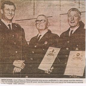 Bendigo Historical Society Inc.
Newspaper - JENNY FOLEY COLLECTION: DEDICATION
Golden Square Fire Brigade was established in High Street, Golden Square, in 1881. A New station building was opened in 2025 in Speciman Gully Road.Bendigo Advertiser '' the way we were'' from 2002. Dedication: Chief Officer A. Pitfield presents long service certificates to Jack Harper and Bob McGann. The two Golden Square firemen have 84 years' service between them and one of the finest service records in the brigade. Date unknown. The clip is in a folder.newspaper, bendigo advertiser, the way we were -
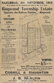 Ringwood and District Historical Society
Flyer, Auction Sale Advertisements - Ringwood Township Estate, Ringwood, Victoria - 1913
Advertisements for auction sale of retail and residential blocks opposite the Ringwood Railway Station on Saturday, 8th November, 1913, showing subdivision layout, terms of sale, and summary of local features and services. Auction at 3 o'clock on the property by order of Mr. O.J. Pratt - 18 township lots, 27 villa blocks, also weatherboard butcher's shop with 5-roomed weatherboard house and good stabling, and 5-roomed new weatherboard villa. Subdivision includes Station Road (later Warrandyte Road), Pratt Street, and Whitehorse Road. Agents - Coghill & Haughton, 79 Swanston Street, Melbourne, Auburn & Canterbury, in conjunction with J.B. McAlpin, Opposite Railway Station, Ringwood. Additional 2 partially trimmed copies allotment maps on cardboard backing with handwritten sales notations. -
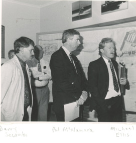 Lakes Entrance Historical Society
Photograph - Tambo Shire Councillors 1991, 1991
Black and white photograph showing Barry Secombe and Michael Ellis of Tambo Shire with Pat McNamara National Party State Leader during presentation of plans for new project taken at Tambo Shire Office Palmer Road Lakes Entrance Victoria local government -
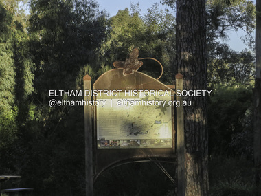
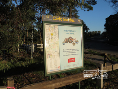 Eltham District Historical Society Inc
Photograph, Liz Pidgeon, Heritage Excursion; Eltham Lower Park, 1 July 2017
Civic Guide sign near the entrance of Eltham Lower Park with a map of the local area and an advertisement for Eltham College Newsletter No., 234, June 2017 Heritage Excursion - Saturday 1st July - Eltham Lower Park - Walk and Talk Eltham Lower Park has played an important part in the history of our area since the early days of European settlement when it was used by local residents as an informal racecourse. Prior to that its location at the junction of the Diamond Creek and the Yarra River made it an important meeting place for the Wurundjeri people. The park combines formal elements and sporting facilities with remnant bushland that is of environmental significance. It is home to sporting and horse riding clubs, popular play spaces and the Diamond Valley Miniature Railway, which attracts large numbers of visitors. The park will be the venue for our July excursion which will comprise a walk of about 3.5 km around the park and adjacent areas. Along the way we will discuss the history and natural history of the area. The path along the creek and the river provides a pleasant and scenic walk. This walk on Saturday 1st July is about 3.5 km in length and will take 2 to 2.5 hours. It will start at 2pm at the Main Road car park at the front of the park. (Melway ref 21 H 10). This sign was removed in about 2021 when works began on the building of an intersection to replace the roundabout at Fitzsimons Lane & Main Road. By May 2023 plantings in green spaces near Eltham Lower Park took place before the official opening of the new Eltham Gateway.Born Digitalheritage excursion, activities, eltham district historical society, eltham lower park, civic guide, eltham college, sign -
 Eltham District Historical Society Inc
Photograph, Liz Pidgeon, Heritage Excursion; Eltham Lower Park, 1 July 2017
Sign at the front of the park which includes a map. Newsletter No., 234, June 2017: Heritage Excursion - Saturday 1st July - Eltham Lower Park - Walk and Talk Eltham Lower Park has played an important part in the history of our area since the early days of European settlement when it was used by local residents as an informal racecourse. Prior to that its location at the junction of the Diamond Creek and the Yarra River made it an important meeting place for the Wurundjeri people. The park combines formal elements and sporting facilities with remnant bushland that is of environmental significance. It is home to sporting and horse riding clubs, popular play spaces and the Diamond Valley Miniature Railway, which attracts large numbers of visitors. The park will be the venue for our July excursion which will comprise a walk of about 3.5 km around the park and adjacent areas. Along the way we will discuss the history and natural history of the area. The path along the creek and the river provides a pleasant and scenic walk. This walk on Saturday 1st July is about 3.5 km in length and will take 2 to 2.5 hours. It will start at 2pm at the Main Road car park at the front of the park. (Melway ref 21 H 10). This sign was removed in about 2021 when works began on the building of an intersection to replace the roundabout at Fitzsimons Lane & Main Road. By May 2023 plantings in green spaces near Eltham Lower Park took place before the official opening of the new Eltham Gateway. The sig Born Digitalelection day, heritage excursion, activities, eltham district historical society, eltham lower park, sign -
![Photograph - Construction of the F19 [Eastern Freeway], Ron Setford, October 1973](/media/collectors/550653872162f11fb04854aa/items/6808c584025de50d1e738e8d/item-media/6808c690025de50d1e73abd2/item-fit-380x285.jpg) Kew Historical Society Inc
Kew Historical Society IncPhotograph - Construction of the F19 [Eastern Freeway], Ron Setford, October 1973
Ron Setford and his wife Grace Setford lived in Tanner Avenue, East Kew, from c.1946 to c.1995. A keen photographer, he recorded the changing face of Kew over a 20 year period. Apart from 30 photographs of built structures and places in Kew dating from 1960 and 1961, 145 of his 35mm colour slides chronicle the development of the F19 (later renamed Eastern) Freeway through the Yarra Valley in Kew over a five year period from c.1972 to c.1977. This important collection was donated to the Society by his granddaughter in 2025.This collection of 175 35mm slides is of local and statewide significance, owing to its subject matter, particularly the major development of road transport infrastructure during the 1970s with the construction of the Eastern Freeway. The photographer also took care to annotate and date most of his slides which enable the researcher to pinpoint temporal and spatial locations."Eastern Freeway / New bridge Kew - Fairfiield"ron setford, eastern freeway, f19 freeway -
![Photograph - Construction of the F19 [Eastern Freeway], Ron Setford, July 1976](/media/collectors/550653872162f11fb04854aa/items/6808c951025de50d1e73dca0/item-media/6808c969025de50d1e73df52/item-fit-380x285.jpg) Kew Historical Society Inc
Kew Historical Society IncPhotograph - Construction of the F19 [Eastern Freeway], Ron Setford, July 1976
Ron Setford and his wife Grace Setford lived in Tanner Avenue, East Kew, from c.1946 to c.1995. A keen photographer, he recorded the changing face of Kew over a 20 year period. Apart from 30 photographs of built structures and places in Kew dating from 1960 and 1961, 145 of his 35mm colour slides chronicle the development of the F19 (later renamed Eastern) Freeway through the Yarra Valley in Kew over a five year period from c.1972 to c.1977. This important collection was donated to the Society by his granddaughter in 2025.This collection of 175 35mm slides is of local and statewide significance, owing to its subject matter, particularly the major development of road transport infrastructure during the 1970s with the construction of the Eastern Freeway. The photographer also took care to annotate and date most of his slides which enable the researcher to pinpoint temporal and spatial locations."New Willsmere Park / 7/76"ron setford, eastern freeway, f19 freeway -
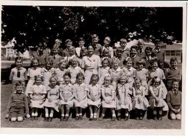 MYLI My Community Library
Photograph - Pakenham Consolidated School Grade Two Class Photo, 1953
Grade 2 of Pakenham Consolidated School in 1953 with their teacher Mrs Joyce Hosking. Back row L to R: Paul Manestar or Bill Vallender, Bernie Carter, (?), Norman Whitelaw, Richard Shelton, Rodney Shallard, Ian Reid (Reidy?) or Duncan Beard (Reidy), Ken Jarred, Glen Jolly. 2nd back row L to R: Keith Crofts, Peter Johnstone, Kevin Lewis, Robert Tulloch (Bones), Nipper Reid, Duncan Beard(?), Bruce Weatherhead, Peter Hobson (Hobbo). 2nd row from front L to R: David Langley, Kath Mauger, Jill Peck, Rosamund Hunt, Beth Schilling, Roslyn Smith, Lynne Tuena, Pat Stone, Joy Higgins, Lynette Wheeler, Grif Fearon or Kevin McInnis. Front row L to R: Ken McCaffrey, Marion Butcher, Helen Stephens, Mary Lou Walsh, Glenis Tuena, Dawn Hillderbrick/ Hillbrick(?), Marion Hansford, Kaye Wollard, Beverley Payne (Payney), Edna Sinclair(?), Paul Braemar. In the 1940s and 1950s there was a movement to consolidate small rural schools into one larger school. This was partly a response to a shortage of teachers, due to many male teachers enlisting during the Second World War. The War also caused a shortage of materials and labour and many Schools fell into disrepair. The Education Department decided that Pakenham would be one of the first six Consolidated Schools to be established and that all schools within 8 kms or 5 miles would be closed. The Pakenham Consolidated School was officially opened on May 29, 1951, on the site of the Pakenham State School, No.1359, in Main Street. The original Pakenham School had opened on a site near the Toomuc Creek in January 1875 and it moved to the Main Street site in 1891. The first Head Master was Charles Hicks. The School offered classes up to Year 10 (Form 4). The schools that formed the Consolidated School were Pakenham Upper No. 2155 (closed January 1952), Pakenham South No. 3755 (closed September 1951), Toomuc Valley No. 3034 (closed September 1951), Army Road No. 3847 (closed April 1947), Mount Burnett No. 4506 (closed October 1949), Tynong No. 2854 (closed April 1951), Tynong North No.4464 (closed December 1951), Nar Nar Goon North No. 2914 (closed October 1951), Nar Nar Goon South No. 4554 (closed May 1951), Rythdale No. 4231 (closed September 1951), Officedale No. 4242 (closed May 1951), Cora Lynn No. 3502 (closed May 1951) and Koo-Wee-Rup North (Five Mile) No. 3198 (closed November 1959). The School consisted of new buildings, which at the time cost one hundred thousand pounds, and many of the old School buildings. Some towns did not realise that their School buildings would be removed from the sites and transferred to Pakenham. The Pakenham Consolidated School moved from its original location in Main Street to its current location in Rundell, Way in 1997.This photograph is of historic and social significance. Pakenham Consolidated School was one of the first six Consolidated Schools established by the Education Department, and was born out of shortages of teachers, labour, and materials during World War II. The school can be used more broadly to reflect on the evolution of education in the state of Victoria, as the school can trace its origins all the way back to 1875, when the original Pakenham School was opened near Toomuc Creek. The photograph is also of social significance to many community groups, including Cardinia Shire, past and current students and teachers, allowing various groups to reflect on and share intangible memories of times spent at Pakenham Consolidated School.Copy of a rectangular black and white photograph on matte photographic paperpakenham consolidated school, primary school, class photo, grade two, grade 2, pakenham, school, photo -
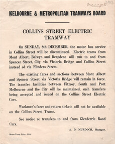 Melbourne Tram Museum
Document, Melbourne & Metropolitan Tramways Board (MMTB), "Collins Street Electric Tramway", Dec. 1929
Set of two Notices to Passengers regarding changes resulting from the opening of the Collins St electric lines to Victoria Bridge as of 8/12/1929. Signed by A D Murdoch, Manager. 1 - Collins St Electric Tramway - noting that the bus service will be discontinued, and electric trams to Victoria Bridge. Existing fares remain applicable but no workmen's fares. 2 - St Kilda Beach - Kew Route - trams will terminate at Glenferrie and Cotham Roads, rather than running to Victoria Bridge. Details fares for the route.Yields information about the opening of the Collins St electric tram service in 1929 and other changes.Set of two Notices printed on quarto paper.Both have "Manager" in top right hand corner.tramways, buses, new tramway, collins st, tram routes, kew -
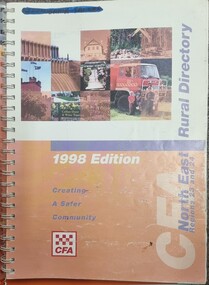 Wodonga & District Historical Society Inc
Book - North East Rural Directory 1998
The CFA North East Rural Directory for Regions 23 and 24 was designed to assist fire brigades and other emergency services in responding to calls in the North East region of Victoria. Its purpose was to minimize response times to emergency situations by providing accurate and detailed information about all of the localities in the regions. District 23 is based at Wangaratta and Extends as far south as Woods Point. District 24 is centred in Wodonga and extends past Corryong to the New South Wales border following the Murray River. It also includes Falls Creek and Mount Hotham.A spiral bound volume including colour topographic maps and illustrations of North East Victoria. The cover features a collage of colour photo of North East Victoria including a CFA firefighter in a truck with members of his family beside it. The book also features a key map, explanation of map references and symbols, localities index. Alphabetical road indexes for Wodonga, Albury, Wangaratta and Benalla as well as township maps and alphabetical road indexes for smaller communities are included.The CFA North East Rural Directory for Regions 23 and 24 was designed to assist fire brigades and other emergency services in responding to calls in the North East region of Victoria. Its purpose was to minimize response times to emergency situations by providing accurate and detailed information about all of the localities in the regions. District 23 is based at Wangaratta and Extends as far south as Woods Point. District 24 is centred in Wodonga and extends past Corryong to the New South Wales border following the Murray River. It also includes Falls Creek and Mount Hotham.emergency management north east victoria, cfa region 24, cfa wodonga, cfa region 23 -
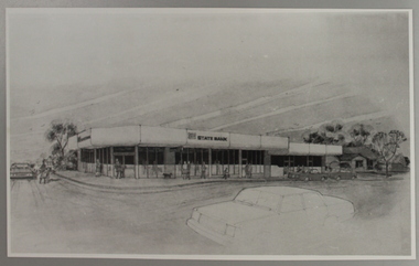 Ringwood and District Historical Society
Photograph, State Bank Artist's Impression, Warrandyte Road, Ringwood North
Artist's Impression of the new Ringwood North State Bank premises, circa 1980At the corner of Dickson's Crescent and Warrandyte Road, Ringwood North -
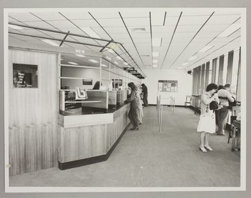 Ringwood and District Historical Society
Photograph, Interior of Ringwood North State Bank , south-east corner of Dickson's Crescent and Warrandyte Road
The new Ringwood North State Bank premises on the south-east corner of Dickson's Crescent. Showing customer service area. Opened 23 August 1982At the corner of Dickson's Cresent and Warrandyte Road, Ringwood North. Photographer - Les Gorrie Photography, 28 Waldemar Road, Heidelberg. Negative #82334 -
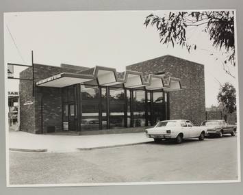 Ringwood and District Historical Society
Photograph, Exterior view of Ringwood North State Bank , north-east corner of Dickson's Crescent and Warrandyte Road
The new Ringwood North State Bank premises on the north-east corner of Dickson's Crescent. Exterior view. Unknown date. Opened 25 October 1971At the corner of Dickson's Crescent and Warrandyte Road, Ringwood North. Photographer Laurie Richards, 4 Tower Avenue, Alphington. Negative #71-3031 -
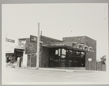 Ringwood and District Historical Society
Photograph, Ringwood North State Bank , north-east corner of Dickson's Crescent and Warrandyte Road
The new Ringwood North State Bank premises, November 1979 on the north-east corner of Dickson's Crescent. Exterior view.At the corner of Dickson's Crescent and Warrandyte Road, Ringwood North. Photographer - Les Gorrie Photography, 28 Waldemar Road, Heidelberg. Negative #2389