Showing 11403 items
matching maps
-
 Vision Australia
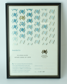
Award - Text, Certificate awarded by the Australian Bicentennial Authority, 2 July 1987
Certificate reads "Awarded to Association for the Arthur Wilkins Northern Suburbs Day Centre. By the Australian Bicentennial Authority which was established to plan and coordinate a nationwide profram of celebrations in 1988 to commemorate the 200th anniversary of permanent European settlement in Australia" Signed by the Executive Director (illegible), dated 2nd July 1987. All text on this certificate is located on the bottom half of the document. 1 x paper certificate from Australian Bicentennial AuthorityThe top half is populated by a repeated stylised graphic of a map of Australia, in various shades of green and gold. There is also a gold version of the same logo, labelled with "Endorsed Bicentennial Activity" , situated above the official signatures. arthur wilkins centre, essendon, association for the blind -
 Diamond Valley Vietnam Veterans Sub-Branch
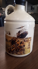
Memorabilia - Bottle, 1992
The bottle of port is one of many memorabilia items from the era.Like all of the Vietnam War memorabilia, this bottle of port is a reminder of the Vietnam War and of the Veterans Service 'in country'. Clay bottle of port; bottle cream in colour with black seal. Bottle has two pictures around the side: black sketch of Vietnam Memorial at Australian War Memorial, Canberra; colour iconic picture of diggers awaiting dustoff. Above the sketch of Vietnam Memorial is text: "Vietnam Memorial', below the sketch is "For all those who served, suffered and died 1962 - 1973"; a map of Vietnam sits between the Vietnam Memorial and the dustoff picture.vietnam, vietnam war, diamond valley vietnam veterans sub branch, memorabilia -
 Wodonga & District Historical Society Inc
Album - Hume Reservoir Australia Album - Plans and Progress Photos - River Murray Water Scheme, Department of Public Works, N.S.W, 1927
This set of photos is from a leather bound album bearing the inscription "HUME RESERVOIR AUSTRALIA" plus 'The Rt. Hon. L. C. M. S. Amery, P. C., M .P.' all inscribed in gold. It was presented to The Rt. Hon. L. C. M. S. Amery, P. C., M. P, Secretary of State for Dominion Affairs on the occasion of his visit to the Hume Reservoir on 2nd November 1927. This album is of local and national significance as it documents the planning and development of the Hume Reservoir up to 1927. It was the largest water reservoir in the British Empire. The album records the pioneering engineering work that went into its construction.1. Locality Plan and Plan of Dam. The dam is about ten miles by road upstream from Albury and about three-quarters of a mile below the confluence of the Mitta Mitta River and the Murray River. Its main features consist of a concrete portion across the bed of the river with earth embankment at both ends. The foundations throughout are on hard granite, found at an average depth of about 40 feet below the surface, the centre line being located to take advantage of the most favourable rock levels.Heading on page "WORKS UNDER RIVER MURRAY WATERS AGREEMENT/HUME RESERVOIR" Beneath top diagram "FIG. 1. ELEVATION" Beneath second diagram "FIG. 2. PLAN" On map "LOCALITY PLAN"hume reservoir australia, river murray waters scheme, hume weir diagrams, hume weir location -
 Ringwood and District Historical Society
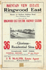
Flyer, Land Sale Brochure, Mountain View Estate, Ringwood East, Vic. - 1923
Bi-fold advertisement for sale of residential allotments, including photographs, map, and summary of subdivision features and local facilities. Undated handwritten notation reads "streets don't exist today".Subdivision layout includes Mullum Mullum Road, Rangeview Avenue, Press Avenue, and Mountview Avenue. Local Agent - J.B. McAlpin, Opposite Railway Station, Ringwood, Phone Ringwood 7. Vendor - T.J. Press, Builder, "Monterey", Second Avenue, Kew, Telephone Haw. 3428. -
 Kiewa Valley Historical Society
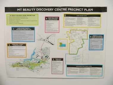
Poster - Mt Beauty Discovery Centre Precinct Plan
The current (2015) Mt Beauty Tourist Centre site was to be upgraded into a 'Sports Tourism Cluster' with funding from the Government and the Alpine Shire with 'In Kind' assistance from Falls Creek Resort management Board, Parks Victoria and the Local Community & Tourism Industry. This project didn't go ahead.The Mt Beauty town was handed over to the Alpine Shire in the 1960's after completion of the Kiewa Hydro Electric Scheme. Plans for up dating facilities are on-going but are rarely completed. This poster is an example of this.Very large laminated poster depicting 6 points for the Alpine Region Sports Tourism Cluster. Each point has a coloured border and background to black writing. There are 3 maps.mt beauty. tourism. discovery centre. sports cluster. -
 Bendigo Military Museum
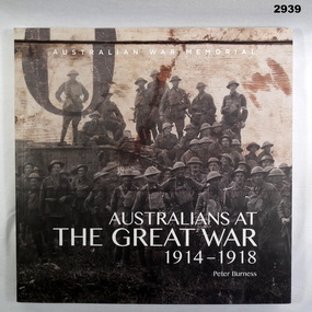
Book - BOOK, THE GREAT WAR, Australian War Memorial et al, Australians at the Great War 1914-1918
Book, paperback, front cover has large group portrait of Australian Soldiers with full kit & steel helmets in front of a tank. 150 pages, illustrated photos, painting & maps.books, the great war, the australians -
 Bendigo Military Museum
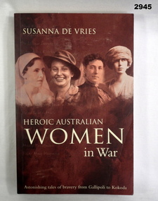
Book - BOOK, HEROIC WOMEN, Susanna De Vries, Heroic Australian Women in War, 2004
Text tells the stories of the bravery of Australian women from Gallipoli to Kokoda.Book, soft cover with sepia illustration depicting 4 women. Title in cream lettering. Black & white photographic illustrations & black & white maps. 296 pages with cut edges.Handwritten in black on 1st page: “O'Brien”book, australian women -
 Bendigo Military Museum
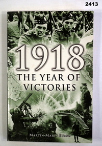
Book - WW1 BOOK, Henson Way, Kettering, 1918 The Year of Victories, c.2005
Soft cover book, 240 pages, illustrated with maps. Cover is slightly green tinted with photographs of Scotish soldiers on an AA mg & A WWI tank. Writing is in black & white ink.books, victories, 1918 -
 Bendigo Military Museum
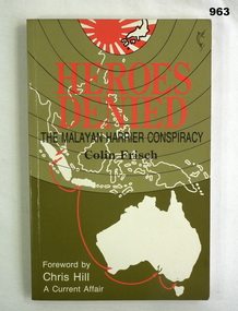
Book, Heroes Denied. The Malayan Harrier Conspiracy, 1990
176 pages. Some black and white photos. 2 tone green. Soft covers, title in red. Subtitle in black - background of map Australia and islands to the north drawn in white.On fly leaf hand written "MIKE BUNDY" books, military history -
 Glenelg Shire Council Cultural Collection
Booklet, c. 1965
Part of a booklet on Portland, 'The Gateway of Opportunity' c 1965. Pages not numbered, so it's unclear whether it is only the front cover missing. Back cover - map of Portland hinterland -
Glenelg Shire Council Cultural Collection
Flyer - Flyer - The Great Southern Touring Rout Adelaide to Melbourne, n.d
DL flyer, single sheet folded four times. 'The Great Southern' touring route, Adelaide to Melbourne, via Mt. Gambier & Geelong'. Contains map of touring route and information -
 Greensborough Historical Society
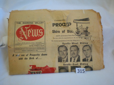
Newspaper, Diamond Valley News, Diamond Valley News. 29 Sept. 1964 : Commemorative edition : Proclamation of the Shire of Diamond Valley, 29/09/1964
The Shire of Diamond Valley was formerly the north ward of the City of Heidelberg. In 1960 following inequitable rate increases, it was proposed that the 'north ward' sever itself from Heidelberg and form its own municipality. The Shire was abolished in 1994 and areas redistributed to Banyule, Nillumbik and Darebin councils.This newspaper reports on the history and politics of the new Shire of Diamond Valley. It includes news articles and advertising material from local businesses. 40 page commemorative edition. Yellowed newsprint. Front cover icludes "The Shire of Diamond Valley" on red outline map of shire and photos of the 12 inaugural councillors. 3 copies.shire of diamond valley, greensborough, diamond valley news -
4th/19th Prince of Wales's Light Horse Regiment Unit History Room
Letter, 13 Oct 1924
A typed letter from the Australian War Memorial to Col M W S Bourchier CMG, DSO, requesting papers, documents or maps of war interest that he may have.bourchier, australian war memorial -
 Orbost & District Historical Society
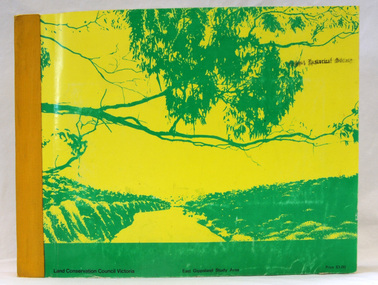
book, Report on the East Gippsland Study Area, June 1974
In 1961 Bruce Evans was elected to the Victorian Legislative Assembly as the member for Gippsland East. He was the party's deputy leader from 1964 to 1970 and its whip from 1970 until his retirement in 1992. "The Land Conservation Council was established by the Land Conservation Act 1970. As one of its three functions, it makes recommendations to the Minister for Planning and Environment with respect to the use of public land, in order to provide for the balanced use of land in Victoria. This report contains the Council’s final recommendations concerning the use of public land in the East Gippsland study area, the boundaries of which correspond to those of the Shire of Orbost. The recommendations in the text are grouped under major headings, such as Parks, State Forest, and so on. " The Council met on seven occasions during the year, and also made visits of inspection to each study area. The Chairman visited Shire Councils in study areas to explain the role and the functions of the Land Conservation Council and to invite submissions on the use of public land in these areas. This is the fourth annual report by the council. This is a useful research tool.A large book 236 pp book with a yellow / gold cover with a green bush scene . The binding is orange. It contains folded maps and information on public land use in East Gippsland.inside - "With Compliments - Bruce Evans, M.P."east-gippsland-study-area conservation public-land-use -
 Federation University Historical Collection
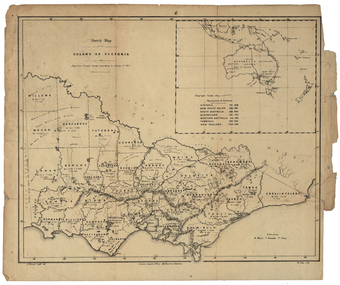
Map, Robert Brough Smyth, Sketch Map of the Colony of Victoria, c1871, c1872
This map includes the population of each County in Victoria according to the 1871 Census, as well as the population of each Australian colony and New Zealand. Telegraph Route is given in a detail at the top right. victoria, victorian counties, robert brough-smyth, telegraph, population, bourke, rodney, dalhousie, evelyn, mornington, buln-buln, tanjil, dargo, delatite, moira, bogong, bendigo, gunbower, grant, talbot, hampden, heytesbury, polwarth, ripon, kara-kara, gladstone, grenville, croajingolong, tambo, benambra -
Glenelg Shire Council Cultural Collection
Administrative record - Progress Report of Portland Harbour - Royal Commission of Victoria, 1925
Retrieved from the files of the former Maritime Discovery Centre Manager at the Portland Information Centre (A copy of this report is listed in the manifest from the Port of Portland when collection was offered in 1995)Front: Capt. J W Brown -inkport of portland -
 Ringwood and District Historical Society
Map - State Aerial Survey, Dandenong Ranges Area, Parts of Parishes of Nunawading, Warrandyte and Ringwood - 1956
Map of Ringwood North and parts of Mitcham, Donvale, Park Orchards and Ringwood East compiled by Dept of Lands and Survey, July 1956, from aerial photographs and Cadastral Survey information. Sheet 1, Ringwood A2D or 849 A2D Zone 7. Scale: 4 chains to 1 inch. Contour interval 20 feet. -
 Bendigo Historical Society Inc.
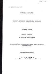
Book - STRAUCH COLLECTION - VICTORIAN LOCALITIES, A HANDY REFERENCE FOR VICTORIAN RESEARCH, FROM THE BOOK 'DIGGING FOR GOLD' BY HELEN DOXFORD HARRIS, 1988
Victorian Localities, a handy reference for Victorian research, from the book 'Digging for Gold' by Helen Doxford Harris, compiled by her from inquest files, parish maps and other sources.Helen D Harrisvictoria, history, localities -
 Bendigo Historical Society Inc.
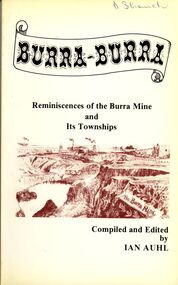
Book - STRAUCH COLLECTION: BURRA BURRA
Soft covered book titled Burra - Burra, Reminiscences of the Burra Mine and Its Townships compiled and edited by Ian Auhl, 160 pages with maps, black and white photographs & illustrations.Ian Auhlhistory, australian, burra burra, history-south australia-burra-mining -
 Bendigo Historical Society Inc.
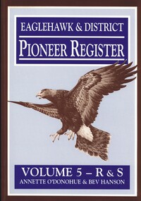
Book - EAGLEHAWK & DISTRICT PIONEER REGISTER VOLUME 5 R - S
Eaglehawk & District Pioneer Register Volume 5 R&S 1544 pages of information relating to Eaglehawk & district pioneers with black and white photographs and maps. Missing. Whereabouts unknown.Annette O'Donohue & Bev Hansonbook, bendigo, bendigo history & its people -
 Bendigo Historical Society Inc.
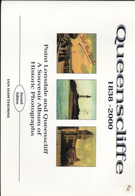
Book - QUEENSCLIFFE 1838 - 2000, 2000
Queenscliffe 1838 - 2000 Point Lonsdale and Queenscliff a Souvenir Album of Historic Photographs, second edition. 72 pages published by Borough of Queenscliffe with photographs, some colour, illustrations and maps.Ian Hawthornehistory, queenscliff, history - point lonsdale & queenscliff, maritime- sailing ships - lighthouses, grand hotels. -
 Bendigo Historical Society Inc.
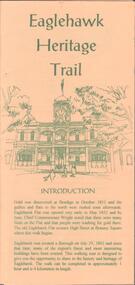
Document - EAGLEHAWK HISTORICAL SOCIETY COLLECTION: EAGLEHAWK HERITAGE TRAIL
Small brochure titled: Eaglehawk Heritage trail, after an introduction a map of the points of interests, few drawing of different buildings, in total the brochure give small information on 33 locations.eaglehawk, history, walking tour -
 Bendigo Historical Society Inc.
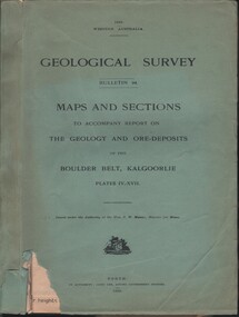
Document - MCCOLL, RANKIN AND STANISTREET COLLECTION: MAPS AND SECTIONS KALGOORLIE, 1929
Document: MCCOLL, RANKIN AND STANISTREET: green cover book Bulletin 94, Maps and Sections to accompany report on the geology and ore deposits of the Boulder Belt, Kalgoorlie. Plages IV - XV11.Government printer, Perthorganization, business, kalgoorlie, mccoll, rankin and stanistreet, kalgoorlie, maps and sections -
 Bendigo Historical Society Inc.
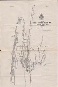
Map - STRUGNELL COLLECTION: HUSTLER'S LINE OF REEFS, BENDIGO, September 1913
Map, Hustler's Line of Reefs, Great Extended Hustler's Mine Plan, Plate No. X1 (11). Bulletin No 33 Signed H.A.Whitelaw Underground survey Office Bendigo September 1913.Underground Survey Office, Bendigo.map, bendigo, great extended hustler's mine -
 Bendigo Historical Society Inc.
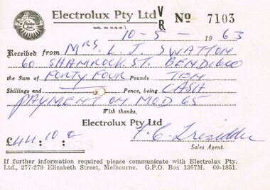
Document - J W SWATTON COLLECTION: ELECTROLUX RECEIPT
Receipt from Electrolux Pty Ltd No 7103 for £44/10/0. Receipt is for payment on Mod 65. Circular Electrolux Logo of a globe map with Electrolux in a circle with rays? at the bottom.person, receipts, j w swatton, j w swatton collection, electrolux pty ltd, f c tresedder? -
Port Melbourne Historical & Preservation Society
Programme - Port Melbourne Community Festival, Maree Menzel et al, Feb 2001
Poster and program promote the two day Festival organised by a community based committee under the auspices of the Port Melbourne Neighbourhood House.Program for the 2001 Port Melbourne Community Festival. Images of Port such as sail and ferry, in pink, blue and green, A3, folded to A6 and including full program of activities, coupons and mapcelebrations fetes and exhibitions, maree menzel, pat grainger, port melbourne neighbourhood house -
 Coal Creek Community Park & Museum
Mine Map
6306.1 - Map of Outtrim mining area, with modification where damage/erasure has occurred. Shows tunnels, faults, tramways, boreholes, surface roads and (apparently) paddock boundaries and a creek. -
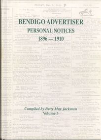 Bendigo Historical Society Inc.
Book - BENDIGO ADVERTISER PERSONAL NOTICES 1896 - 1910
Hardcover book with 504 pages of personal notices published in the Bendigo Advertiser 1896 - 1910 compiled by Betty May Jackman Volume 3 some black and white photographs & a map.Betty May Jackmanbooks, catalogues, personal notices -
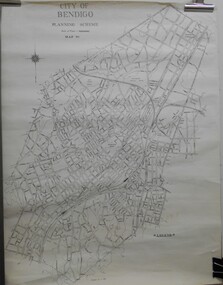 Bendigo Historical Society Inc.
Map - JACK FLYNN COLLECTION: BENDIGO, Revised 1/01/1961
Map: Bendigo city, it has City of Bendigo Planning Scheme as the title. Showing the city within the Municipal Boundaries, also has contour lines and the Major Gullies. Revised 1.1.1962.map, bendigo, city streets, bendigo planning scheme -
Bendigo Historical Society Inc.
Map - BENDIGO (PART), No date visible
Map: Portion of Bendigo parish plan, showing from Murphy St. East to Bob St and between rail line to old saleyards to the old Heathcote line Canvas backed.map, bendigo, city streets, bendig parish plan , bendigo city streets